
The depopulated village of Lubya / District of Tiberias
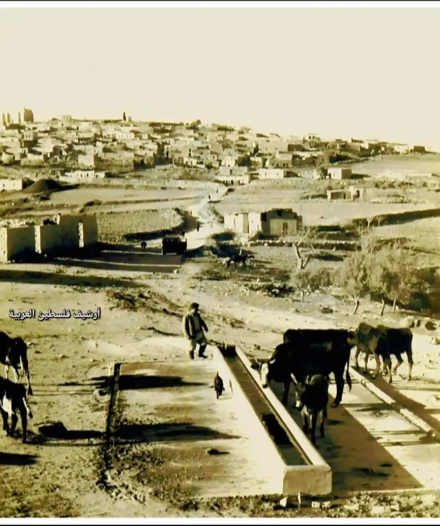
About the depopulated village of Lubya
- District
- Tiberias
- Date Lubya was occupied
- 18 July 1948
- Population in 1948
- 2,730
- Military operation
- Operation Dekel
- Who defended the village
- Local militia & Arab Liberation Army
- Distance from the governorate centre
- 10.5 (km) West of Tiberias
- Elevation above sea level
- 300 m
- Cause of displacement
- Military assault by Zionist troops
- Extent of destruction
- Lubya was completely defaced, and only house rubble left behind.
- Ethnic cleansing
- Lubya inhabitants were completely ethnically cleansed.
- Settlements built on the built-up area of Lubya after 1948
- Lavi
Hover a dot to read the village name, or click to open its card.
Borders of the depopulated village of Lubya
Lubya: A Depopulated Palestinian Village in the Tiberias District
Lubya was a Palestinian village in the Tiberias District, located about 10.5 kilometres west of the city of Tiberias, on a rocky hill at an average elevation of approximately 300 metres above sea level. During the British Mandate period, it was the second-largest village in the Tiberias District in terms of land area. Its inhabitants resisted several attacks during 1948 before most of them were displaced on the night of 16 July. Israeli forces entered the village the following day in the context of Operation Dekel during the Nakba and the occupation of Palestine in 1948.
- Subdistrict
- Tiberias
- Distance from district center
- 10.5 km West of Tiberias
- Average Elevation
- 300 meters above sea level
- Population in 1931
- 1,850 inhabitants - Official census
- Number of Houses in 1931
- 405 houses - Official census
- Population in 1944/1945
- 2,350 inhabitants - Government of Palestine statistics
- Estimated Population in 1948
- About 2,726 inhabitants - a later demographic estimate, not an official census
- Total Land Area in 1945
- 39,629 dunams
- Attack and Depopulation
- The Attack of 20 January 1948 The Palestinian press reported that Zionist forces attacked Lubya on the night of 20 January 1948, resulting in the death of one village resident. The newspaper Filastin reported that the assault was coordinated with another raid against the nearby village of Tur'an.
- Final Israeli Control
- 17-18 July 1948
- Military Operation
- Operation Dekel
- Military Unit
- The Zionist forces attacking in the context of Operation Dekel; the reviewed sources do not identify a single brigade with certainty
- Cause of Depopulation
- Military assault by Zionist troops
- Settlements Documented on Village Lands
- Lavi
Location
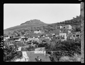
Lubya stood on the summit of an elongated rocky hill extending from east to west and overlooking the Tur'an Plain to the south.
The village was divided into eastern and western sections by a secondary road that connected Lubya with the main Tiberias–Nazareth road. The older houses, as well as most of those constructed during the British Mandate period, were concentrated in the eastern section, which overlooked the village's agricultural lands.
Nimrin was among the closest villages to Lubya to the north. Other neighbouring villages and localities included Hittin, Tur'an, al-Shajara, Kafr Sabt, and Khirbat al-Manara.
Lubya Through History
During the Crusader period, Lubya was known as “Lubia.” The Muslim scholar Abu Bakr al-Lubyani, who became known during the fifteenth century and taught religious sciences in Damascus, was associated with the village.
In 1596, Lubya was a village in the Tiberias subdistrict of the Safad district. Walid Khalidi and PalQuest estimate its population at approximately 1,177. Its inhabitants paid taxes on goats, beehives, and a press used for processing olives or grapes.
Another Palestinian reading of the same Ottoman tax register estimates the population at approximately 942. The sixteenth-century population figure should therefore be treated as a historical estimate rather than as a modern direct census.
In 1743, Sulayman Pasha, the governor of Damascus, died at Lubya while travelling to confront Zahir al-Umar.
In the early nineteenth century, British traveller James Silk Buckingham described Lubya as a large village situated on the top of a hill. Later in the century, it was described as a stone-built village on the edge of a ridge of white limestone. Its population, then estimated at between 400 and 700, cultivated olives and figs.
Architecture and Education
Most of Lubya's houses were concentrated in the eastern part of the hill, and the village expanded in that direction because it overlooked the agricultural lands.
The built-up area amounted to approximately 210 dunams according to the 1944/1945 statistics.
An elementary school was established in Lubya in 1895 during the Ottoman period and continued to operate under the British Mandate.
Population
The 1922 Census of Palestine recorded approximately 1,712 inhabitants in Lubya, including 1,705 Muslims, four Christians, and three Druze.
In the 1931 census, the population reached 1,850, including 1,849 Muslims and one Christian, living in 405 houses.
According to the 1944/1945 Village Statistics, Lubya had a population of 2,350 Palestinian Arabs, all recorded as Muslims.
The estimate of approximately 2,726 inhabitants in 1948 and the estimate of 16,741 refugees and descendants in 1998, published by Palestine Remembered, are later estimates rather than official censuses of the Government of Palestine.
Population of Lubya
- 1596About 1,177Historical estimate according to PalQuest and Walid Khalidi; other Palestinian estimates are lower
- Late nineteenth centuryAbout 400–700Historical estimates
- 19221,712Official census
- 19311,850Official census
- 1944/19452,350Government of Palestine statistics
- 1948About 2,726Later estimate
- 199816,741Estimate of refugees and their descendants
Number of Houses
The 1931 census recorded 405 houses in Lubya. The figure of approximately 596 houses for 1948, published by Palestine Remembered, is a later estimate.
Number of Houses in Lubya
- 1931405Official census
- 1948About 596Later estimate
Land of Lubya
During the British Mandate period, Lubya was the second-largest village in the Tiberias District in terms of land area. According to the 1944/1945 statistics, its lands covered a total of 39,629 dunams.
Arab ownership amounted to 32,895 dunams, Jewish ownership to 1,051 dunams, while 5,683 dunams were classified as public land.
Land Ownership in Lubya in 1944/1945
- Arab ownership32,895 dunums83%
- Jewish ownership1,051 dunums3%
- Public land5,683 dunums14%
Agriculture and Economic Life
Lubya's economy depended primarily on agriculture, and its lands were known for their fertility. The village was particularly known for its wheat, which was cultivated mainly in the lower lands of the Tur'an Plain, while olive trees grew on the hilly slopes north of the village.
The inhabitants also cultivated figs and other fruit trees.
According to the 1944/1945 statistics, a total of 32,310 dunams were devoted to cereals, including 31,026 dunams of Arab-owned land, 1,051 dunams of Jewish-owned land, and 233 dunams of public land.
A further 1,655 dunams were irrigated or used for plantations, all of them Arab-owned. Approximately 1,520 dunams of agricultural land were planted with olive trees.
The olive acreage should not be added separately to the overall land-use total because it formed part of the cultivated and plantation land.
Land Use in Lubya in 1944/1945, in Dunams
- Arab
- Jewish
- Public
- Cereals32,310 dunums
- Irrigated and plantation land1,655 dunums
- Built-up area210 dunums
- Uncultivable land5,454 dunums
Archaeology in Lubya
Lubya was built over the remains of earlier settlements, making the village and its surroundings an archaeological area.
Sources record rock-cut tombs and ancient stone blocks that were reused in construction. However, the principal sources reviewed do not provide sufficient evidence to identify these remains specifically as Greek.
Approximately 2 kilometres east of the village stood the ruins of a structure known as Khan Lubya. The site contained remains of a pool, cisterns, and large building stones. Walid Khalidi suggests that it may have served as an inn or caravan station during the Ottoman period.
The Nakba and the Defense of Lubya
The Attack of 20 January 1948
The Palestinian press reported that Zionist forces attacked Lubya on the night of 20 January 1948, resulting in the death of one village resident. The newspaper Filastin reported that the assault was coordinated with another raid against the nearby village of Tur'an.
Clashes in February and March
On the morning of 24 February, a clash lasting approximately four hours took place on the outskirts of Lubya between Palestinians and a Jewish convoy. According to Filastin, one Palestinian was killed and two were wounded, while casualties were also reported among members of the convoy.
In early March, a Haganah force attempted to open the road between Tiberias and al-Shajara by force and attacked Lubya at dawn, reaching its western outskirts. Arif al-Arif reports that the villagers repelled the assault, with seven members of the attacking force and six Palestinian defenders killed.
Another infiltration toward the village took place on 11 March following artillery fire.
The June Battle
Following the occupation of Tiberias in April 1948, the inhabitants of Lubya became increasingly isolated and sought assistance from Nazareth and Arab forces operating in the area.
On 10–11 June 1948, shortly before the First Truce began, Lubya was subjected to another attack. Testimonies collected by Palestinian historian Nafez Nazzal indicate that an Israeli infantry unit succeeded in taking positions on the southern edge of the village but withdrew by the night of 11 June.
Lubya's local militia also briefly participated alongside the Arab Liberation Army in an attack on the nearby settlement of Sejera before returning to defend the village during the truce.
Operation Dekel and the Occupation of Lubya
Operation Dekel
Following the end of the First Truce, Operation Dekel began on 8 July 1948 and continued until 18 July. The operation aimed to take control of large areas of Lower Galilee, including the city of Nazareth and numerous Palestinian villages.
Forces from the Seventh Brigade, the Carmeli Brigade, and the Golani Brigade participated in Operation Dekel as a whole. However, the principal Palestinian sources dealing specifically with the occupation of Lubya do not conclusively identify one of these brigades as solely responsible for entering the village. Instead, they refer to an Israeli armored unit approaching Lubya.
Displacement of the Population
News of the fall of Nazareth reached Lubya on 16 July. Testimonies from villagers indicate that the inhabitants requested military assistance from Arab Liberation Army units in the region, but that assistance did not arrive.
During the night of 16 July, most of the population left the village, initially heading toward Nimrin and Eilabun. Many later continued toward Lebanon. A number of members of the local militia and some elderly residents remained behind.
Date of Occupation
The sources differ slightly regarding the precise date of occupation. Palestine Remembered records 16 July 1948 as the occupation date, while the more detailed sequence reproduced by Walid Khalidi and PalQuest indicates that most residents left on the night of 16 July and that an Israeli armored unit approached the village the following day.
When the armored force advanced on 17 July, the local militia, which was suffering from a shortage of weapons, decided to withdraw. Eyewitness testimony indicates that Israeli forces shelled Lubya before entering it, after which some houses were destroyed and others were seized.
It is therefore more historically precise to state that the displacement and military occupation of Lubya took place during 16–17 July 1948, with most inhabitants leaving on the night of 16 July and Israeli forces completing their entry into the village the following day.
Fate of the Population and Buildings
Some elderly inhabitants remained in Lubya after most of the population had left, and several took shelter in a cave near the village. A small number later managed to escape, while the account reproduced by Walid Khalidi does not provide confirmed information regarding the fate of all those who remained.
Following the occupation, some houses in Lubya were destroyed, while Israeli forces took possession of others. During the subsequent period, further demolition took place until most of the village's original built-up area disappeared.
The Palestinian community of Lubya was completely displaced, and its inhabitants were not permitted to return and re-establish their village.
Occupation and Depopulation Chronology
- 20 January 1948
The Attack of 20 January 1948
The Palestinian press reported that Zionist forces attacked Lubya on the night of 20 January 1948, resulting in the death of one village resident. The newspaper Filastin reported that the assault was coordinated with another raid against the nearby village of Tur'an.
- April 1948
The June Battle
Following the occupation of Tiberias in April 1948, the inhabitants of Lubya became increasingly isolated and sought assistance from Nazareth and Arab forces operating in the area. On 10–11 June 1948, shortly before the First Truce began, Lubya was subjected to another attack.
- 8 July 1948
Operation Dekel
Following the end of the First Truce, Operation Dekel began on 8 July 1948 and continued until 18 July. The operation aimed to take control of large areas of Lower Galilee, including the city of Nazareth and numerous Palestinian villages.
- 16 July 1948
Date of Occupation
The sources differ slightly regarding the precise date of occupation. Palestine Remembered records 16 July 1948 as the occupation date, while the more detailed sequence reproduced by Walid Khalidi and PalQuest indicates that most residents left on the night of 16 July and that an Israeli armored unit approached the village the following day.
Israeli Settlements and Projects on the Lands of Lubya
Lavi
The settlement of Lavi was established in 1949 on the northeastern part of Lubya's lands.
Giv'at Avni
Giv'at Avni does not appear in Walid Khalidi's original list of settlements associated with Lubya because it was established at a later date. However, more recent Palestinian field documentation published by Palestine Remembered places Giv'at Avni on the eastern lands of Lubya, in an area known as Manjaba.
Forests and Other Projects
Lavi Forest, consisting largely of pine trees, was planted on the western side of the village site. Another forest was planted nearby and was named after South Africa. Trees eventually covered substantial portions of the ruins of Lubya's houses.
A military museum commemorating the Golani Brigade was also established near the village site.
| Name | Date | Relationship to the Village Site |
|---|---|---|
| Lavi | 1949 | Established on the northeastern part of Lubya's lands |
| Giv'at Avni | Established later | More recent Palestinian field documentation places it on the eastern lands of Lubya |
| Lavi Forest | After the Nakba | Planted west of the village site and covering parts of the ruins |
| Golani Brigade Museum | After the Nakba | Established near the village site |
The Site of Lubya After the Nakba
According to the field documentation used by Walid Khalidi, pine forests came to cover a large part of the Lubya village site, concealing the ruins of many houses beneath the trees.
Several scattered wells that had been used by the villagers to collect rainwater remained, along with pomegranate and fig trees and a small number of cactus plants.
The lands surrounding the site were used for agriculture. According to historical field documentation, traces of the old secondary road that once connected Lubya with the Tiberias–Nazareth road could still be identified.
Later Palestinian field documentation also records remains of village stones, wells, the cemetery, and features associated with the former village lands.
These descriptions reflect field documentation carried out at different times and should not necessarily be interpreted as a comprehensive survey of the Lubya site updated to 2026.
Sources
- PalQuest – Interactive Encyclopedia of the Palestine Question: Lubya.
- PalQuest: Operation Dekel.
- Palestine Remembered: Lubya, Tiberias District.
- Palestine Remembered: Dr. Muhammad Aqel's Study of Lubya.
- Palestine Remembered: Historical and Geographical Facts about Lubya.
- Walid Khalidi, All That Remains, entry on Lubya.
- Arif al-Arif, works dealing with the Nakba and the fighting in the Tiberias region.
- Nafez Nazzal, The Palestinian Exodus from Galilee, 1948, Institute for Palestine Studies, Beirut, 1978.
- Government of Palestine, censuses of 1922 and 1931.
- Government of Palestine, Department of Statistics, Village Statistics, 1945.
Photo gallery


Photos from the village's people
Photos sent in by visitors and published after review.
Add a photo of this village
Log in to add photos of this village.
Other villages from Tiberias
More from the archive


 Download Our Palestine App
The whole archive in the palm of your hand: depopulated villages, the Nakba, the massacres and Al-Aqsa — free, with no ads to erase the story.
Download Our Palestine App
The whole archive in the palm of your hand: depopulated villages, the Nakba, the massacres and Al-Aqsa — free, with no ads to erase the story.



Comments
No comments yet — be the first to write one.
Add your comment
Name and email are optional. Comments appear after review.