Bethlehem before the Nakba: Pearl, Embroidery, Pilgrimage
This article is part of the Palestine before the Nakba series.
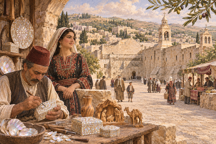
In Bethlehem before the Nakba, a piece of mother-of-pearl left the craftsman’s hands to travel to the far corners of the world, and an embroidered dress carried the work and taste of the women who made it. Pilgrims came to the Church of the Nativity, and around it the townspeople lived among homes, workshops, schools and markets, building their ties to the world through work and trade. [1][2][3]
Then came the Nakba. Bethlehem took in refugees driven by Zionist forces from the villages of the Jerusalem and Hebron areas; the Dheisheh and Aida camps were set up on its edges, and after 1967 the occupation encircled it with settlements and the wall. [4][5][6]
Contents
- Bethlehem before the Nakba at a glance
- Location: on the Jerusalem–Hebron road
- The Church of the Nativity
- The old town: homes above workshops
- Population and building under the Mandate
- The market
- Mother-of-pearl: a craft that travelled the world
- Olive wood
- Traders and emigrants
- Women and embroidery
- Education and health
- Christmas and pilgrimage
- The municipality and the Mandate
- The Nakba: a town receives the uprooted
- From the Nakba to occupation: Bethlehem after 1967
- Timeline
- Frequently asked questions about Bethlehem before the Nakba
Bethlehem before the Nakba at a glance
| Item | Details |
|---|---|
| Location | South of Jerusalem, next to Beit Jala and Beit Sahour |
| Population | 6,658 (1922), 6,814 (1931), about 8,820 (1945) |
| Landmark | The Church of the Nativity and the pilgrimage route along Star Street |
| Signature crafts | Mother-of-pearl, olive wood and embroidery |
| Municipality | Founded in 1872 |
| In the Nakba | Refugees received; Dheisheh (1949) and Aida (1950) camps set up |
| Occupation | June 1967 |
Sources: [7][1][8][9][3][10][4][5][11]
Location: on the Jerusalem–Hebron road
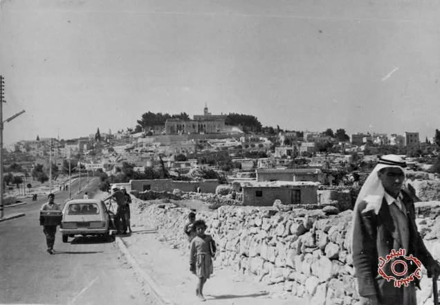
Bethlehem lies south of Jerusalem on hills joined to its mountains, with Beit Jala to the north-west and Beit Sahour to the east: three towns bound by work, kinship and neighbourliness. [7]
The town was shaped by the road: the pilgrims’ route from Jerusalem and the trade route to Hebron and the villages. The traditional pilgrimage route enters the town along Star Street to Manger Square. [1]
The Church of the Nativity
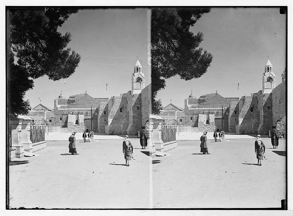
The Church of the Nativity stands over the place identified as the birthplace of Christ. The first church was completed in 339 CE, while the present building dates from its rebuilding in the sixth century. In 2012 UNESCO inscribed it on the World Heritage List, the first Palestinian site on the list. [1][12]
When Caliph Umar ibn al-Khattab visited the church after the conquest and the time for prayer came, he prayed there, then wrote a covenant keeping it for Christians and barring Muslims from congregational prayer at its doors, lest his act become a pretext for taking it over. [12]
Pilgrimage was part of the life of an inhabited town: the pilgrim came to the church, then entered the market and bought what its people made. [2]
The old town: homes above workshops
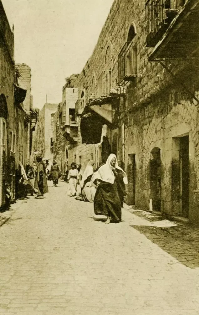
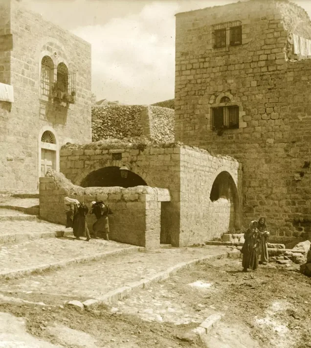
UNESCO describes the nineteenth- and twentieth-century stone buildings of the pilgrimage route: homes on the upper floors and workshops at street level opening onto the road, bringing living and working space together. [1]
Population and building under the Mandate
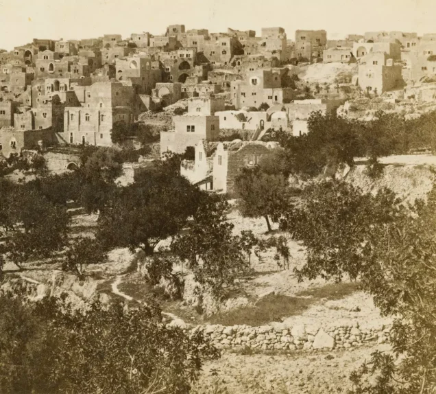
Bethlehem had 6,658 people in 1922, 6,814 in 1931 and about 8,820 in 1945. Emigrants’ money fuelled building under the Mandate, invested in homes, shops and businesses. [7]
The market
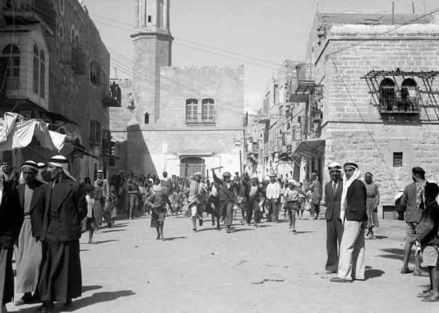
Photographs show a market where animals, vehicles and people moved together, goods on display and shops facing the street. From the market, local crafts passed to visitors and traders and on to distant places, a route documented since the nineteenth century. [13][2]
Read also: Markets and trade in Palestine before 1948.
Mother-of-pearl: a craft that travelled the world
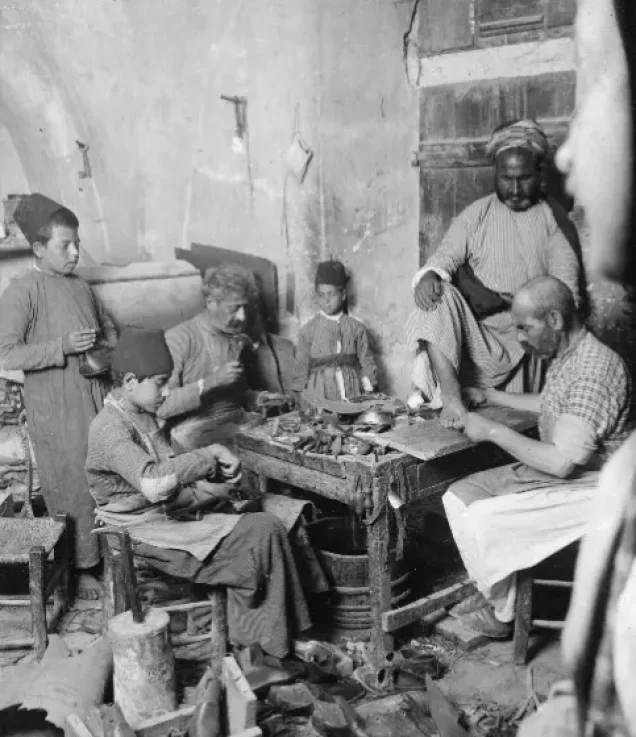
Bethlehem was renowned for mother-of-pearl work, from rosaries and crosses to boxes, frames and fine models. Bethlehem University notes that the craft flourished from the mid-nineteenth century with growing demand from pilgrims and foreign markets, and that the shell was imported from around the world. [8]
The work requires cutting, design, assembly and polishing, and its skills passed down within families, so the craft became tied to households that preserved and developed it over generations. [8]
Olive wood
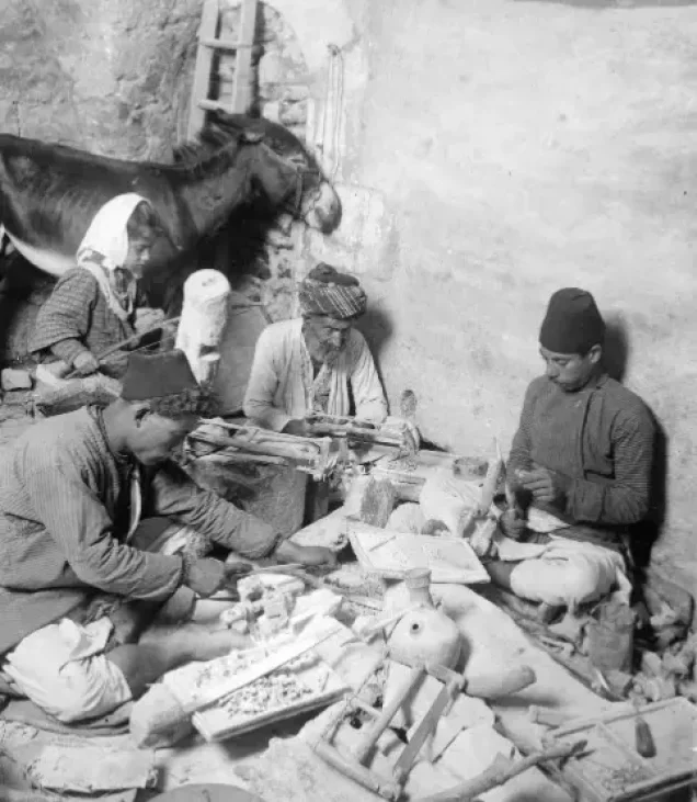
Alongside mother-of-pearl, Bethlehem was known for olive-wood work; the Bethlehem Museum presents both crafts as part of local production and its link to pilgrimage. Vocational training in the town also covered carpentry, smithing, shoemaking and printing. [9]
Read also: Industry and crafts in Palestine before the Nakba.
Traders and emigrants
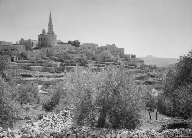
Historian Jacob Norris studied Bethlehem’s traders in the late Ottoman period, showing that from the second half of the nineteenth century they built networks to market religious crafts, and by the 1880s had shops as far apart as Manila, Kyiv, Singapore and Port-au-Prince. [2]
Women and embroidery
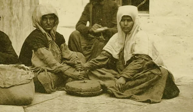
The Palestinian Museum holds a dress from the Bethlehem area dating to around 1850–1900, of dark hand-woven cloth decorated with metallic and silk thread, floral motifs and couching (tahriri) stitch, and classed as everyday wear. Its patches and alterations show it was worn and mended. [3]
In the 1930s and 1940s Bethlehem women produced embroidered pieces and ready-made dresses for the local wedding market; embroidery was paid work as well as a mark of identity. [14]
Read also: Palestinian women before the Nakba.
Education and health
The roots of what became Bethlehem University go back to 1893, when its first building was put up as part of the De La Salle Brothers’ educational work; the university itself was founded in 1973. [15]
Among its pre-Nakba medical institutions was the Holy Family Hospital, whose land was bought in 1882 and which served as a general hospital offering treatment, surgery and maternity care. [16]
Read also: Palestinian education before 1948; Medicine and health before the Nakba.
Christmas and pilgrimage
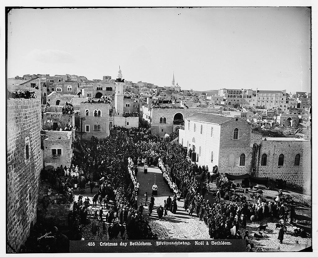
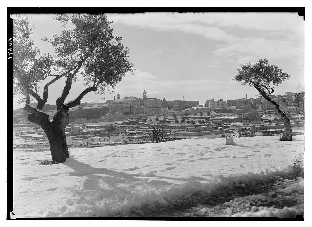
Photographs of Christmas processions gather crowds, costumes and buildings in Manger Square, among them one from the early twentieth century. A 1941 photograph shows the town and the church under snow from the Jerusalem road. [17]
Read also: Tourism, hotels and pilgrims before the Nakba.
The municipality and the Mandate
Bethlehem’s municipality was founded in 1872, decades before the British Mandate. Under the Mandate the town joined the revolt against British rule, and rebels attacked its British police station. [10][7]
The Nakba: a town receives the uprooted
Bethlehem stayed outside the control of Zionist forces in 1948, but the Nakba changed its life with the arrival of refugees those forces had driven from their homes; it then came under Jordanian rule until Israel occupied it in 1967. [11]
Dheisheh camp was set up in 1949 on the main road south of the town for refugees from villages in the Jerusalem and Hebron areas, and Aida camp in 1950 on land leased by UNRWA. [4][5]
Read also: Depopulated villages; Palestinian refugee camps.
From the Nakba to occupation: Bethlehem after 1967
Israel occupied Bethlehem in 1967 with the rest of the West Bank. On 2 April 2002, during the “Defensive Shield” invasion, its forces besieged the Church of the Nativity and those who had taken refuge in it for more than 35 days; 8 Palestinians were killed and 14 wounded, and the siege ended with 13 Palestinians exiled abroad and 26 to Gaza. [11][12]
By 2022 the occupation had built 16 settlements and 16 outposts in Bethlehem governorate, home to about 78,938 settlers, more than 60,000 of them in the Gush Etzion bloc. The wall runs 82 kilometres through the governorate and, when complete, will isolate some 176,524 dunams; it encircles the Rachel’s Tomb area at the town’s northern entrance, in effect annexing it to Jerusalem. [6]
Bethlehem thus carries two memories: that of a town of mother-of-pearl, embroidery and pilgrimage, and that of the refugees who brought it the names of their villages and still hold to the right to return.
Timeline
| Year | Event |
|---|---|
| 339 CE | First Church of the Nativity completed [1] |
| 1872 | Bethlehem municipality founded [10] |
| 1882 | Land bought for the Holy Family Hospital [16] |
| 1893 | Building that later housed Bethlehem University put up [15] |
| 1945 | About 8,820 people in the town [7] |
| 1948 | The Nakba and the arrival of refugees [11] |
| 1949 | Dheisheh camp set up [4] |
| 1950 | Aida camp set up [5] |
| 1967 | Israel occupies Bethlehem [11] |
| 2002 | Siege of the Church of the Nativity for over 35 days [12] |
| 2012 | Church of the Nativity inscribed as a World Heritage Site [12] |
Frequently asked questions about Bethlehem before the Nakba
What was Bethlehem’s population in 1945?
About 8,820. [7]
What was Bethlehem known for before 1948?
The Church of the Nativity and pilgrimage, mother-of-pearl and olive-wood crafts, embroidery, and its traders’ worldwide networks. [1][8][9][2]
When was the Church of the Nativity built?
The first church was completed in 339 CE; the present building dates from the sixth century. [1]
What is the story of Umar ibn al-Khattab and the church?
He prayed there during his visit, then wrote a covenant keeping it for Christians and barring Muslims from congregational prayer at its doors. [12]
Was Bethlehem occupied in 1948?
No. It took in refugees in 1948 and was occupied by Israel in 1967. [11]
Which refugee camps are near Bethlehem?
Dheisheh (1949) and Aida (1950), whose people come mostly from depopulated villages of the Jerusalem and Hebron areas. [4][5]
When was the Church of the Nativity besieged?
From 2 April 2002, for more than 35 days. [12]
Read also on Palestinuna
- Bethlehem and its photographs
- Dheisheh camp
- Aida camp
- Tourism and pilgrimage before the Nakba
- Palestine before the Nakba
Sources and references
- UNESCO, “Birthplace of Jesus: Church of the Nativity and the Pilgrimage Route, Bethlehem”.
- Jacob Norris, “Exporting the Holy Land: Artisans and Merchant Migrants in Ottoman-Era Bethlehem,” Mashriq & Mahjar, 2013.
- The Palestinian Museum, “Bethlehem Dress” (in Arabic).
- UNRWA, “Dheisheh Camp”.
- UNRWA, “Aida Camp”.
- Palestinian National Information Center – WAFA, “Settlement in Bethlehem Governorate” (in Arabic).
- Palestinian Encyclopedia, “Bethlehem (city)” (in Arabic).
- Bethlehem University, “Mother of Pearl: An Art and a Source of Economic Sustenance,” 2020.
- Bethlehem Museum, “Museum Sections”.
- Bethlehem Municipality, official website.
- Bethlehem Municipality, “History of Bethlehem”.
- “The Church of the Nativity: Palestine’s Oldest Church,” Al Jazeera Encyclopedia, 2 June 2024 (in Arabic).
- Palestinuna, “Bethlehem photo gallery”.
- Qatar Museums, “Labour of Love: Embroidering Palestinian History”.
- Bethlehem University, “About BU”.
- Order of Malta, “Holy Family Hospital, Bethlehem”.
- Palestinuna, “Tourism, Hotels and Pilgrims in Palestine before the Nakba”.
More from the archive
 Download Our Palestine App
The whole archive in the palm of your hand: depopulated villages, the Nakba, the massacres and Al-Aqsa — free, with no ads to erase the story.
Comments
No comments yet — be the first to write one.
Add your comment
Name and email are optional. Comments appear after review.