
The depopulated village of Madahil / District of Safed

Madahil
About the depopulated village of Madahil
- District
- Safed
- Date Madahil was occupied
- 30 April 1948
- Population in 1948
- 340
- Military operation
- Operation Yiftach
- Brigade that carried it out
- Palmach
- Distance from the governorate centre
- 30 (km) North East of Safad
- Elevation above sea level
- 100 m
- Cause of displacement
- Fear of Jewish attack, or of being caught in the fighting
- Extent of destruction
- The village has been completely defaced
- Ethnic cleansing
- Madahil inhabitants were completely ethnically cleansed.
Hover a dot to read the village name, or click to open its card.
Madahil – Depopulated Palestinian Village of Safad
Madahil was a small Palestinian village in the Safad Subdistrict, situated on flat ground along the northeastern edge of the al-Hula Plain approximately 30 kilometers northeast of Safad and about 100 meters above sea level.
The village lay approximately one kilometer east of Wadi Banyas and less than one kilometer south of Tall al-Turmus, a nearby archaeological mound containing evidence of settlement dating to the fourth millennium B.C.
The 1931 Census of Palestine recorded 100 inhabitants in Madahil, all Muslims, living in seventeen houses. No independently documented 1945 population or land-ownership table has been located in the principal sources used here.
Madahil's inhabitants left in late April 1948 during Operation Yiftach and the broader military offensive in eastern Galilee. Khalidi and PalQuest give 30 April as the departure date, while the Palestine Land Society register gives 29 April. The available account emphasizes fear of an impending attack or of being caught in the fighting, while also suggesting that mortar fire may have accelerated the departure.
Basic Information
| Field | Information |
|---|---|
| Name | Madahil |
| Arabic name | مَداحِل |
| Subdistrict | Safad |
| Region | Northeastern edge of the al-Hula Plain |
| Distance from Safad | Approximately 30 km northeast |
| Elevation | Approximately 100 m above sea level |
| Palestine Grid | 210/290 |
| Population in 1931 | 100, all Muslims |
| Houses in 1931 | 17 |
| Population in 1945 | No independently documented figure located |
| 1948 population | No reliable independent estimate located |
| Independent land area | No sufficiently documented independent 1945 land table located |
| Depopulation date | 30 April 1948 according to Khalidi/PalQuest; another Palestinian register gives 29 April |
| Military operation | Operation Yiftach; Operation Matateh began later, on 4 May, and therefore cannot have directly caused the late-April departure |
| Military unit | Palmach forces within Operation Yiftach; Palestine Remembered specifies the First Battalion, but Khalidi's village account does not independently establish a village-level unit |
| Cause of depopulation | Fear of impending attack or of being caught in the fighting; possible mortar fire may have accelerated the evacuation |
| Destruction | No village structures remained in Khalidi's later field survey; the precise demolition date is not documented |
| Israeli settlements on village lands | None according to Walid Khalidi and PalQuest |
Name
No securely documented linguistic derivation of the name Madahil was located in the principal Palestinian sources consulted.
The article therefore retains the documented village name without introducing unsupported tribal or linguistic explanations.
Location and Geography
Madahil stood on level terrain at the northeastern edge of the al-Hula Plain, approximately 30 kilometers northeast of Safad.
Wadi Banyas lay about one kilometer west of the village, while Tall al-Turmus stood less than one kilometer to the north.
Palestinian local documentation places al-Mansura to the north, Syrian territory to the east, al-Hamra' to the south, al-'Abisiyya and Qaytiyya to the southwest, Lazzaza to the west, and al-Khisas to the northwest.
Population
Madahil does not have the complete series of population statistics available for many larger villages in the Safad Subdistrict.
| Year | Population | Note |
|---|---|---|
| 1922 | No independently documented figure located | No figure is inferred from neighboring communities |
| 1931 | 100 | Official census; all inhabitants were Muslims |
| 1944/45 | No independently documented figure located | No separate official village figure was found in the principal sources used here |
| 1948 | No reliable independent estimate | No population is extrapolated mathematically from the 1931 census |
Number of Houses
The official 1931 census recorded 17 occupied houses in Madahil.
No reliable official 1948 house count has been located, and no estimate is derived from population figures.
Land and Land Ownership
No sufficiently documented independent Madahil entry was located in the available 1945 land statistics from which a reliable ownership or land-use table could be constructed.
The Palestine Land Society's register likewise does not supply an independent village land area.
This article therefore does not invent land totals or divide ownership into Palestinian, Transferred to Zionists, and Public categories without an explicit documentary basis.
Economy
Madahil was a small rural community situated within the fertile agricultural environment of the al-Hula Plain. Its proximity to Wadi Banyas placed it within a well-watered landscape.
However, in the absence of an independent village land-use table, precise cereal, orchard, or grazing acreage cannot be supplied responsibly.
Later field documentation confirms that land surrounding the former village site continued to be cultivated after depopulation.
Education and Services
No independently documented school, enrollment figures, or teacher totals have been located for Madahil in the principal sources used here.
Given the small size of the community, no school, clinic, or administrative building is assumed without documentary evidence.
Religious Buildings and Cemetery
No independently documented mosque, shrine, or cemetery specific to Madahil was located in the principal sources consulted.
The fact that the 1931 population was entirely Muslim does not by itself establish the existence of a particular mosque building.
Tall al-Turmus
Tall al-Turmus stood less than one kilometer north of Madahil.
Archaeological evidence from the mound indicates settlement dating to the fourth millennium B.C.
The ancient mound should be distinguished from the modern Palestinian village. Geographic proximity alone does not demonstrate uninterrupted settlement from the prehistoric site to twentieth-century Madahil.
Operation Yiftach
Operation Yiftach began on 15 April 1948 and continued until 25 May as part of the military campaign for eastern Galilee.
Palmach forces formed the principal striking force, and the First Battalion spearheaded important phases of the wider operation.
Madahil was depopulated during this campaign and before the final assault on Safad on 10–11 May.
Depopulation in Late April 1948
Khalidi and PalQuest date the departure of Madahil's inhabitants to 30 April 1948, while the Palestine Land Society register records 29 April.
Khalidi's account does not describe a documented ground battle inside Madahil or identify troops entering the houses on that day.
Instead, he cites later intelligence reporting that inhabitants of a number of eastern Galilee villages left during the offensive out of fear of attack.
For Madahil, fear of an impending attack or of being caught in the fighting is the principal documented explanation. Khalidi also considers it possible that Haganah mortar fire accelerated the departure.
The available account does not specify the destination to which the villagers fled.
Was Operation Matateh Responsible for Madahil's Depopulation?
Some Palestine Remembered summary fields associate both Operation Yiftach and Operation Matateh, or “Broom,” with Madahil.
Operation Matateh was launched on 4 May 1948 and targeted Palestinian and Bedouin communities east of Safad and west of the Jordan River, including al-Zanghariyya, 'Arab al-Shamalina, and al-Tabigha.
Because the inhabitants of Madahil had already left on 29–30 April according to the principal chronology, the 4 May operation cannot have been the direct cause of their departure.
Operation Yiftach is therefore the appropriate military framework for Madahil's depopulation, while Operation Matateh belongs to the subsequent escalation across the wider Hula and Jordan Valley region.
Military Unit
Palmach forces spearheaded Operation Yiftach as a whole.
Palestine Remembered identifies the Palmach's First Battalion as the unit associated with Madahil.
Khalidi's village-specific account, however, does not independently identify a battalion that entered Madahil or describe a confirmed ground assault on the village on 30 April. The First Battalion attribution is therefore retained as a source-specific identification and broader operational context rather than as conclusively established village-level fact.
Cause of Depopulation
The most cautious formulation is that the inhabitants left because of fear of an impending military attack or of being trapped in the expanding fighting in eastern Galilee.
The source also raises the possibility that mortar fire by Haganah forces accelerated the evacuation, but does not independently establish a direct bombardment of Madahil beyond doubt.
The village should therefore not automatically be classified as having been emptied by a documented ground assault when the available village-specific account emphasizes fear, military pressure, and possible shelling.
Destruction
All village structures had disappeared by the time of Khalidi's later field survey.
The sources used here do not establish when the buildings were demolished or whether demolition took place immediately after the inhabitants left.
The late-April depopulation date and the later disappearance of the built environment should therefore be treated as separate historical events.
Ethnic Cleansing in Source Classification
Palestine Remembered classifies Madahil using the term “complete ethnic cleansing.” The phrase is retained here only as an attributed source classification.
The directly documented facts are that the inhabitants left during Operation Yiftach under fear of attack and fighting, did not re-establish permanent residence at the village site, and that all village structures later disappeared.
Occupation and Depopulation Chronology
| Date | Event |
|---|---|
| 15 April 1948 | Operation Yiftach begins in eastern Galilee. |
| Second half of April 1948 | Military pressure and raids increase across eastern Galilee and the Hula region, prompting population flight from several villages. |
| 29 April 1948 | Date recorded for Madahil's depopulation in the Palestine Land Society register. |
| 30 April 1948 | Date used by Khalidi and PalQuest for the villagers' departure; fear of attack or of being caught in the fighting is the principal documented cause, with possible mortar fire accelerating the evacuation. |
| 4 May 1948 | Operation Matateh is launched elsewhere in the eastern Galilee-Jordan Valley area; it postdates Madahil's depopulation. |
| 10–11 May 1948 | The final assault on Safad takes place during Operation Yiftach. |
| After depopulation | The village structures disappear at an undetermined date. |
Israeli Settlements on Madahil's Lands
According to Walid Khalidi and PalQuest, no Israeli settlement was established on Madahil's village lands.
Kefar Szold, founded in 1942 before the Nakba, lies approximately 1.5 kilometers southeast of the village site.
Some Palestinian local sources describe Kefar Szold as having been founded on Madahil land, but Khalidi explicitly states that it was not located on village lands. This article follows Khalidi's village-specific cadastral distinction.
Residents of Kefar Szold later cultivated land surrounding the former village site.
Madahil Today
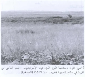
According to the field description used by Walid Khalidi before the publication of All That Remains in 1992, no trace of any village structure remained at Madahil.
The site was covered with grass, reeds, and cactus, while surrounding land was cultivated by residents of Kefar Szold.
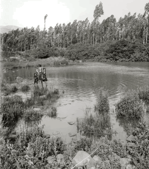
Palestine Remembered also contains later Palestinian community photographs documenting Wadi Banyas and agricultural land around the former village area. These constitute community documentation rather than a comprehensive archaeological or cadastral survey.
Khalidi's account should therefore be understood as documented historical fieldwork from before 1992, not as a comprehensive direct survey of Madahil's condition in 2026.
Sources
- PalQuest – Interactive Encyclopedia of the Palestine Question: Madahil
- PalQuest – Operation Yiftach
- PalQuest – Operation Matateh and its chronology
- Palestine Remembered – Madahil, Safad Subdistrict
- Palestine Remembered – Madahil entry from Walid Khalidi's All That Remains
- Government of Palestine – Census of Palestine 1931
- Palestine Land Society – Register of Depopulated Localities in Palestine
- Palestinian Villages Encyclopedia – Madahil
- Falastinuna – Madahil, Safad Subdistrict
Photo gallery


Photos from the village's people
Photos sent in by visitors and published after review.
Add a photo of this village
Log in to add photos of this village.
Other villages from Safed


More from the archive



 Download Our Palestine App
The whole archive in the palm of your hand: depopulated villages, the Nakba, the massacres and Al-Aqsa — free, with no ads to erase the story.
Download Our Palestine App
The whole archive in the palm of your hand: depopulated villages, the Nakba, the massacres and Al-Aqsa — free, with no ads to erase the story.



Comments
No comments yet — be the first to write one.
Add your comment
Name and email are optional. Comments appear after review.