
The depopulated village of Saliha / District of Safed

About the depopulated village of Saliha
- District
- Safed
- Date Saliha was occupied
- 30 October 1948
- Population in 1948
- 1,241
- Military operation
- Operation Hiram
- Brigade that carried it out
- The Seventh Brigade
- Distance from the governorate centre
- 12 (km) North of Safad
- Elevation above sea level
- 675 m
- Cause of displacement
- Military assault by Zionist troops
- Extent of destruction
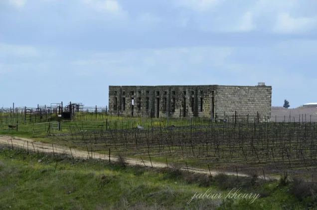
- The village has been mostly destroyed with the exception of the deserted village school
- Ethnic cleansing
- Saliha inhabitants were completely ethnically cleansed.
Hover a dot to read the village name, or click to open its card.
Borders of the depopulated village of Saliha
Saliha – Depopulated Palestinian Village in Safad Subdistrict
Saliha, also rendered Salha, was a Palestinian village in the Safad subdistrict of Upper Galilee. It stood approximately 12 kilometers north of Safad near the Lebanese border, at an average elevation of about 675 meters above sea level.
The village occupied a level area at the edge of the steep Wadi Saliha. A dirt track connected it with two roads, one leading toward the coastal highway and the other toward Safad.
The 1931 Census of Palestine recorded 742 inhabitants in 142 houses, all Muslims. The official 1944/45 statistics require an important qualification: the published statistical unit was “Saliha (includes Maron er Ras and Yarin).” Its population of 1,070 and total land area of 11,735 dunums therefore should not be presented as independently measured figures for Saliha alone.
Saliha experienced at least two military phases in 1948: a reported temporary occupation on 18 May and its final capture on 30 October during Operation Hiram. Khalidi's account also documents a massacre during the final occupation, citing former Haganah National Staff chief Israel Galili as stating that 94 people were killed inside a house that was blown up.
Key Facts about Saliha
| Field | Information |
|---|---|
| Name | Saliha / Salha |
| Subdistrict | Safad |
| Distance from Safad | Approximately 12 km north |
| Average elevation | Approximately 675 m above sea level |
| Population, 1931 | 742 in 142 houses, all Muslims |
| Population, 1944/45 | 1,070 for the statistical unit “Saliha (includes Maron er Ras and Yarin),” not an independent Saliha-only total |
| Land area, 1944/45 | 11,735 dunums for the same combined statistical unit |
| Reported first occupation | 18 May 1948 – apparently temporary |
| Final occupation | 30 October 1948 |
| Military operation | Operation Hiram during the final occupation |
| Military unit | Sheva' / Seventh Brigade during the final occupation |
| Cause of depopulation | Military occupation, massacre, and probable subsequent expulsion of survivors |
| Extent of destruction | Most of the village was destroyed; a long building, probably the school, survived in Khalidi's field documentation |
| Settlements on village land | Yir'on – 1949; Avivim – 1960 |
Saliha and the Seven Border Villages
Saliha had an unusual administrative history because of its position along the Palestine–Lebanon frontier.
It was one of the “Seven Villages” whose inhabitants had been recorded in Lebanese census registers under the French Mandate but who later found themselves on the Palestinian side following Franco-British border demarcation.
The Seven Villages were Tarbikha, Abil al-Qamh, Hunin, al-Nabi Yusha', Qadas, al-Malikiyya, and Saliha.
Saliha had formerly belonged to the Ottoman qada of Marja'uyun and subsequently entered the Safad subdistrict of Mandatory Palestine.
This border history explains why a normal British-Palestinian 1922 census figure should not simply be inserted for Saliha in the same way as for villages that were already firmly within the British census area.
Location
Saliha stood in the Upper Galilee mountains near the Lebanese border.
Its houses occupied level ground at the edge of the steep Wadi Saliha.
A dirt track linked the village to two roads: one toward the Mediterranean coastal highway and another toward Safad.
Its proximity to Kafr Bir'im, Sa'sa', al-Malikiyya, and the frontier routes made the locality militarily significant in 1948.
Saliha in the Late Nineteenth Century
The Survey of Western Palestine described Saliha in the late nineteenth century as a village of approximately 200 inhabitants.
Residents cultivated gardens in the surrounding area and built their houses largely from basalt stones set in mud mortar.
Drinking water came from several cisterns and a large pond.
Population
Saliha's demographic record must distinguish independent census figures from the combined 1945 statistical unit.
- Late nineteenth centuryApproximately 200Survey estimate, not an official census
- 1931742Official independent census figure for Saliha; all Muslims
- 1944/451,070Official statistical unit “Saliha (includes Maron er Ras and Yarin),” not a Saliha-only total
- 19481,241Later Palestine Remembered estimate derived from the combined 1945 baseline; not an independent census of Saliha
- 19987,622Later estimate of refugees and descendants, not an official census
Important Note on the 1945 Figure
PalQuest displays 1,070 among Saliha's key figures, but the underlying Village Statistics 1945 entry explicitly reads:
Saliha (includes Maron er Ras and Yarin).
The 1,070 total therefore belongs to the published combined statistical unit and should not be silently converted into a precise population count for Saliha alone.
Number of Houses
- 1931142Official independent Census of Palestine figure
- 1948237Later Palestine Remembered estimate, not an official census count
Land Ownership in 1944/45
The official 1944/45 statistics give a total land area of 11,735 dunums for the unit labeled “Saliha (includes Maron er Ras and Yarin).”
The following figures should therefore be treated as statistics for that combined unit rather than automatically as cadastral figures for Saliha alone.
- Arab / Palestinian11,730 dunums100%
- Jewish / Transferred to Zionists0 dunums0%
- Public / Communal5 dunums<1%
The figures balance exactly: 11,730 + 5 = 11,735 dunums.
Because the Mandatory record explicitly combined the localities, the figures should not be used to claim that every one of these dunums belonged exclusively to Saliha without more detailed cadastral documentation.
Land Use in 1944/45
The same qualification applies to the official land-use figures for the combined statistical unit.
- Arab
- Public
- Cereals7,401 dunums
- Plantations and irrigable land422 dunums
- Built-up land58 dunums
- Non-cultivable land3,854 dunums
The figures balance exactly:
7,401 + 422 + 58 + 3,854 = 11,735 dunums.
Olive Acreage
Palestine Remembered lists approximately 20 dunums of olive groves.
This should be treated as a subcategory of cultivated/orchard land rather than as an additional acreage to be added again to the land-use total.
Economic Life
The inhabitants depended largely on agriculture and orchard cultivation.
Nineteenth-century descriptions mention gardens surrounding the village, while the 1944/45 statistical unit shows cereal cultivation as the dominant land use.
Fruit trees and olives also formed part of the agricultural landscape.
Because the official 1945 figures combined Saliha with Maron al-Ras and Yaroun, precise Saliha-only crop acreage cannot be extracted from those totals without more detailed records.
Water Resources
The inhabitants obtained drinking water from several cisterns and a large pond.
Such storage systems were well suited to the mountainous environment of Upper Galilee.
Khalidi's entry does not provide a separate list of named springs for the village.
Education
Saliha had an elementary boys' school.
Khalidi and PalQuest do not provide a documented founding year or pupil enrollment total, so no unsupported date or number has been added.
In Khalidi's later field description, the only substantial surviving structure was a long building with many high windows, which he thought may have been the village school.
Archaeological Remains
Saliha contained several archaeological features, including rock-cut tombs, traces of mosaic floors, and olive presses.
Nearby Khirbat al-Sanifa also contained older remains, including a circular pressing floor.
These features should not all be assigned to a single historical period without specialist archaeological investigation.
The Reported May 1948 Occupation
United Press, citing Arab military sources in Amman, reported that Saliha and Kafr Bir'im fell to Israeli forces on 18 May 1948.
Khalidi notes, however, that this occupation must have been temporary if the report was accurate.
The village was again inhabited and involved in military events at the end of October during Operation Hiram.
The principal sources reviewed do not establish how control reverted after the May episode or identify the force responsible for any recapture.
Operation Hiram
Operation Hiram began on 28 October 1948 and ended on 31 October.
It was a large-scale offensive directed against the last major Arab-held pocket in Upper Galilee after the second truce.
At the operation level, forces from the Sheva' or Seventh, Carmeli, Golani, and 'Oded brigades participated.
Within approximately three days most of Upper Galilee was occupied. In numerous localities residents either fled or were expelled, while further expulsions from frontier villages continued afterward.
Final Occupation of Saliha
Saliha's final occupation occurred on 30 October 1948 during Operation Hiram.
The Seventh Brigade had been ordered to advance northeastward from Sa'sa' toward al-Malikiyya.
During this advance its forces encountered what the Israeli military account quoted by Khalidi described as “light resistance” near Saliha.
The military account provides little detail about the action that followed, but Khalidi's sources directly connect the Seventh Brigade's advance with the events that occurred at Saliha that day.
The Saliha Massacre
Khalidi documents a massacre at Saliha on 30 October 1948, at the end of Operation Hiram.
He cites Israel Galili, former head of the Haganah National Staff, who briefed Mapam officials on atrocities committed during Operation Hiram, particularly those attributed to the Seventh Brigade.
According to Galili's account as reproduced by Khalidi, 94 people at Saliha were killed inside a house that was blown up.
The figure of 94 is therefore presented here as the documented figure in the source attributed to Galili, rather than as the product of a modern independent forensic investigation.
Other later accounts circulate different casualty totals, but Khalidi's Saliha entry uses the figure of 94 from Galili's account.
Expulsion of Survivors
The Palestinian community disappeared from Saliha following the massacre and occupation.
Khalidi considers it probable that any surviving villagers were expelled together with residents of most other frontier villages during the clearing of the border zone after Operation Hiram.
His village entry does not reproduce a separate written expulsion order for Saliha or establish an independent date for the departure of the last survivors.
The directly documented sequence is therefore final occupation, massacre, and complete depopulation, while the precise movements of every surviving group are less fully documented.
Cause of Depopulation and Ethnic Cleansing
Palestine Remembered classifies the cause of depopulation as military assault and characterizes the final result as complete ethnic cleansing.
Khalidi's documented sequence establishes military occupation during Operation Hiram, the massacre at Saliha, and the probable expulsion of surviving villagers along with other frontier populations.
The term “ethnic cleansing” is therefore retained as an attributed characterization used by Palestine Remembered, while the directly documented descriptive outcome is the complete removal of Saliha's Palestinian community through occupation, massacre, and subsequent expulsion of those who survived.
Occupation Chronology
- 18 May 1948
Reported first occupation
United Press, citing Arab military sources, reported the fall of Saliha and Kafr Bir'im; Khalidi considers Saliha's occupation at this stage likely temporary.
- Summer–autumn 1948
Village remained inhabited
The presence of villagers at the end of October demonstrates that the May episode was not the final depopulation.
- 28 October 1948
Beginning of Operation Hiram
Israeli forces launched the major offensive against the remaining Arab-held pocket in Upper Galilee.
- 30 October 1948
Seventh Brigade advance
The brigade advanced from Sa'sa' toward al-Malikiyya and encountered light resistance near Saliha.
- 30 October 1948
Final occupation
Saliha fell during the final stages of Operation Hiram.
- 30 October 1948
Saliha massacre
Khalidi cites Israel Galili as reporting that 94 people were killed inside a house that was blown up.
- After occupation
Expulsion of survivors
Khalidi considers it probable that survivors were expelled with residents of other frontier villages; the precise date is not separately established.
- 31 October 1948
End of Operation Hiram
The operation ended after Israeli forces had occupied most of Upper Galilee.
- Precise demolition date not documented
Destruction
Most of the village was destroyed; a long building, probably the former school, survived in Khalidi's field survey.
Israeli Settlements on Saliha's Lands
| Settlement | Established | Relationship to Saliha |
|---|---|---|
| Yir'on | 1949 | Established on the village site itself |
| Avivim | 1960 | Established on Saliha's lands northeast of the former village site |
Saliha Today
According to Walid Khalidi's field description, the only major surviving landmark was a long building with many high windows, possibly the former village school.
The village site had become a flat area used mostly for cultivation.
Much of the surrounding land was planted with apple trees.
This description derives from fieldwork undertaken before the publication of All That Remains in 1992 and should therefore be treated as documented historical site evidence rather than comprehensive direct field verification of conditions in 2026.
Palestine Remembered contains later community documentation, including photographs of the former school, village ruins, agricultural land, and oral-history interviews with people from Saliha. These materials add valuable community memory but do not constitute a comprehensive independent archaeological survey of all village lands.
Sources
- PalQuest – Interactive Encyclopedia of the Palestine Question: Saliha
- PalQuest – Operation Hiram
- PalQuest – Palestine–Lebanon Border and the Seven Villages
- Palestine Remembered – Saliha, Safad District
- Sami Hadawi – Village Statistics 1945, Safad population and land ownership table
- Sami Hadawi – Village Statistics 1945, Safad land-use table
- Government of Palestine – Census of Palestine 1931
- Institute for Palestine Studies – All That Remains, Walid Khalidi
Photo gallery




Photos from the village's people
Photos sent in by visitors and published after review.
Add a photo of this village
Log in to add photos of this village.
Other villages from Safed


More from the archive



 Download Our Palestine App
The whole archive in the palm of your hand: depopulated villages, the Nakba, the massacres and Al-Aqsa — free, with no ads to erase the story.
Download Our Palestine App
The whole archive in the palm of your hand: depopulated villages, the Nakba, the massacres and Al-Aqsa — free, with no ads to erase the story.



Comments
No comments yet — be the first to write one.
Add your comment
Name and email are optional. Comments appear after review.