
The depopulated village of Al-Khisas / District of Safed
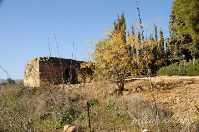
Al-Khisas
About the depopulated village of Al-Khisas
- District
- Safed
- Date Al-Khisas was occupied
- 25 May 1948
- Population in 1948
- 550
- Military operation
- Operation Yiftach
- Brigade that carried it out
- Palmach
- Distance from the governorate centre
- 31 (km) North East of Safad
- Elevation above sea level
- 100 m
- Cause of displacement
- Haganah 'Wispering' campaign (psychological warfare)
- Extent of destruction
- The village has been completely destroyed, and only house rubble left behind.
- Ethnic cleansing
- al-Khisas was ethnicaly cleansed as a result of psychological warfare conducted on the 25th of May 1948.
- Settlements built on the land of Al-Khisas before 1948
- Nehalim (HaGoshrim Today)
- Settlements built on the built-up area of Al-Khisas after 1948
- HaGoshrim Expansion
Hover a dot to read the village name, or click to open its card.
Borders of the depopulated village of Al-Khisas
al-Khisas: A Depopulated Palestinian Village in the Safad District
al-Khisas was a Palestinian village in the Safad District, situated in the northern Hula Plain approximately 31 km northeast of Safad, at an average elevation of about 100 metres above sea level. It stood on a natural terrace near the Hasbani River, and its Palestinian Muslim and Christian inhabitants depended principally on agriculture. On 18 December 1947, al-Khisas was subjected to a night raid by a Haganah strike force in which civilians, including children, were killed and several houses were demolished. Most inhabitants left on 25 May 1948, at the end of Operation Yiftach, amid a psychological-warfare campaign. The departure was only partial: some villagers remained for more than a year and were forcibly expelled by Israeli troops on 5 June 1949 and transported to the area of 'Akbara.
Location of al-Khisas
al-Khisas stood in the northern part of the Hula Plain on a natural terrace approximately 100 metres wide.
The terrace had formed as the ancient Lake Hula, which once occupied a much larger part of the Hula basin, receded over time.
The village was approximately 31 km northeast of Safad and had an average elevation of about 100 metres above sea level.
The Hasbani River passed west of al-Khisas, cutting its course through the surrounding terrain.
A secondary road linked the village with the main highway leading to Safad and Tiberias, while another secondary road connected it with a neighboring village.
Nearby localities and lands included al-Sanbariyya, al-Shuwayka, Dafna, al-Zuq al-Tahtani, Qaytiyya, al-Mansura, and al-'Abisiyya.
Historical Background
The Arab geographer Yaqut al-Hamawi, who died in 1229, described al-Khisas as one of the villages associated with Banyas in Syria.
Rock-cut tombs and a nearby local shrine provide evidence that the site was inhabited before the development of the modern village.
Population of al-Khisas
The Palestinian Arab population of al-Khisas included both Muslims and Christians.
In 1944/45, the Arab population was 470: 400 Muslims and 70 Christians.
The official statistical total for the wider unit was 530 because it also included 60 Jews.
The figure of 530 should therefore not be presented as though all were Palestinian Arab villagers.
Population of al-Khisas in selected years
- 1931386Official British Mandate census
- 1944/45 – Arab population470400 Muslims and 70 Christians
- 1944/45 – full statistical unit530470 Arabs + 60 Jews
- 1948545Later Palestine Remembered estimate; the page retains a parenthetical reference to 60 Jews and this is not an official Mandate figure
- Estimated refugees in 19983,348Later Palestine Remembered estimate; it should be treated cautiously because the site's demographic baseline mixes Arab and Jewish population figures
The current Arabic PalQuest page contains an evident typographical error stating that the 1945 Arab population comprised 400 Muslims and 700 Christians. The English entry and the official total establish that the correct Christian figure is 70.
Number of Houses
Number of houses in al-Khisas
- 193173Official British Mandate census
- 1948103Later estimate published by Palestine Remembered
Education and Public Services
Khalidi's principal PalQuest entry does not provide sufficiently documented information concerning an independent school, clinic, or other specific public institution in al-Khisas before the Nakba.
No unsupported institutional details are therefore added.
Economic Life in al-Khisas
Agriculture was the principal source of livelihood.
Fruit orchards extended south of the village along the Hasbani River, while olive trees grew on the western village lands.
In 1944/45, 4,166 dunums were irrigated or used for plantations: 1,438 Arab dunums and 2,728 Jewish dunums.
The fertility and water resources of the Hula Plain allowed an unusually large share of the registered land to be cultivated.
Land Ownership in al-Khisas
The total registered land area of al-Khisas was 4,795 dunums in the 1944/45 statistics.
Land ownership in al-Khisas, 1944/45, using Palestine Remembered's ownership terminology
- Palestinian1,480 dunums31%
- Transferred to Zionists2,738 dunums57%
- Communal/Public577 dunums12%
Palestinian land represented approximately 31 percent of the total, land in the category “Transferred to Zionists” approximately 57 percent, and communal/public land approximately 12 percent.
Land Use in al-Khisas, 1944/45
PalQuest's detailed official land-use table uses the original categories Arab, Jewish, and Public. The table below preserves those source categories.
Land use in al-Khisas according to the detailed 1944/45 statistics
- Arab
- Jewish
- Public
- Plantations and irrigable land4,166 dunums
- Built-up area40 dunums
- Non-cultivable land589 dunums
Cultivated or cultivable land totaled 4,166 dunums, approximately 87 percent of the village lands.
Built-up and non-cultivable land together amounted to 629 dunums, approximately 13 percent of the total.
Palestine Remembered's simplified table requires two corrections when compared with PalQuest's detailed figures: Jewish built-up land was 10 dunums rather than 20, and the 589 dunums of non-arable land consisted of 12 Arab dunums and 577 public dunums rather than being entirely Palestinian.
Archaeological and Religious Landmarks
A local shrine known as Maqam Shaykh 'Ali stood in the area between al-Khisas and al-Mansura.
Rock-cut tombs also provide evidence of earlier settlement in the area.
Palestine Remembered additionally identifies Tall al-Batiha west of the village, at an elevation of approximately 164 metres above sea level, with a mound of ruins, surface pottery fragments, and scattered stones.
The Tall al-Batiha details are attributed specifically to Palestine Remembered because they are not described with the same specificity in Khalidi's principal entry.
The 18 December 1947 Raid on al-Khisas
al-Khisas was subjected to a major night attack several months before Operation Yiftach.
On 18 December 1947, a Haganah strike force entered the village under cover of darkness, fired weapons, threw bombs, and demolished several houses.
Khalidi, citing Benny Morris, gives a death toll of twelve civilians, including four children.
A contemporary New York Times report gave a total of ten dead, including five children, and stated that some victims were buried beneath the ruins of their homes.
The casualty total therefore differs between the two accounts, but both establish that civilians and children were among those killed.
Khalidi reports that some local Haganah intelligence officers and civilian leaders opposed the planned retaliatory operation, but Palmach commander Yigal Allon approved it.
The raid was presented in the contemporary account as retaliation for the killing of two members of the Jewish Settlement Police in the Safad area.
Operation Yiftach and al-Khisas
Operation Yiftach ran from 15 April to 25 May 1948 and was conducted by Palmach forces to seize control of eastern Galilee.
The Palmach's First Battalion spearheaded the broader operation.
In addition to direct military assaults, Operation Yiftach employed psychological warfare, including the “whispering campaign” intended to induce Palestinian inhabitants of eastern Galilee and the Hula Plain to leave their villages.
Palestine Remembered places al-Khisas within Operation Yiftach and lists the Palmach First Battalion as the attacking unit.
Khalidi's dedicated al-Khisas entry, however, does not describe a village battle on 25 May or independently establish the First Battalion as the specific force that entered al-Khisas. The broader operational role and the village-specific evidence should therefore be distinguished.
The 25 May 1948 Exodus
According to the account reproduced by Khalidi, most inhabitants of al-Khisas left on 25 May 1948, the final day of Operation Yiftach.
An Israeli military intelligence report attributed the dispersal of the population to the psychological-warfare campaign conducted during the operation.
The intelligence document is not used here as an independent Israeli source; its information is included through Khalidi and PalQuest.
The May departure was not complete, however. A section of the population remained in al-Khisas after the fighting.
Twenty-five May should therefore not be described as the final expulsion of every inhabitant of the village.
The Final Forced Expulsion in 1949
Some inhabitants continued living in al-Khisas for more than a year after the principal 1948 exodus.
At midnight on 5 June 1949, Israeli army trucks surrounded the village and the remaining residents were forcibly removed from their homes.
Khalidi, citing Morris, reproduces the account of a Mapam Knesset member who described the villagers as being subjected to kicks, curses, and mistreatment.
The residents also stated that they were forced to demolish their own dwellings.
They were then transported to a bare hillside near 'Akbara, south of Safad, where they were left without adequate shelter or supplies and lived in harsh conditions for years.
Palestinians remaining in several other Safad District villages were transferred to the 'Akbara area in similar circumstances.
The date in the original draft should therefore be corrected from June 1948 to 5 June 1949.
Chronology of the Depopulation of al-Khisas
- 18 December 1947: Haganah night raid; several houses demolished and between ten and twelve civilians killed according to differing accounts, including children.
- 15 April–25 May 1948: Operation Yiftach in eastern Galilee.
- 25 May 1948: principal exodus from al-Khisas, associated with the psychological-warfare campaign at the end of Operation Yiftach.
- May 1948 exodus: partial; some inhabitants remained in the village.
- 5 June 1949: final forced expulsion of the remaining residents and their transfer to the area near 'Akbara.
Israeli Settlement on al-Khisas Lands
The Israeli settlement of ha-Gosherim was established in 1948 on al-Khisas lands.
It lies a few hundred metres south of the former village site.
Significantly, ha-Gosherim was established before the remaining Palestinian residents of al-Khisas were finally expelled in June 1949.
- ha-Gosherim: established in 1948 on al-Khisas lands, a few hundred metres south of the village site.
al-Khisas Today
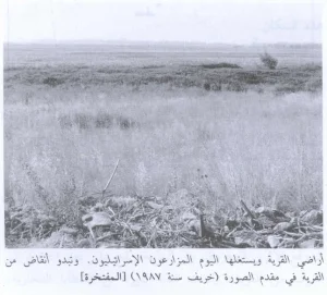
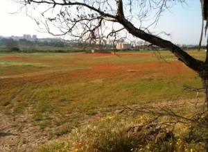
According to the field description published by Walid Khalidi in All That Remains, woods and grass covered most of the former village land.
Piles of stones and clusters of cactus plants were scattered across the site.
The remains included an old structure and a large arched stone barrage.
At the time of Khalidi's documentation, the lands of al-Khisas were cultivated by residents of ha-Gosherim.
Palestine Remembered preserves later community documentation of the village, including photographed visits to the mill and its water sources and images uploaded on 11 June 2025 under the title “All that remains from the mill.”
The upload date alone does not establish when every photograph was taken or make the material a comprehensive independent field survey.
Khalidi's description, published in 1992, therefore remains the principal systematic field account used here, supplemented cautiously by later community documentation. The approved sources do not provide a sufficiently comprehensive independent 2026 field survey to establish the precise present condition of every part of al-Khisas.
Sources
- PalQuestPalQuest – Interactive Encyclopedia of the Palestine Question: al-Khisas
- PalQuestPalQuest – Operation Yiftach
- Palestine RememberedPalestine Remembered – al-Khisas, Safad District
- Palestine RememberedPalestine Remembered – al-Khisas entry from All That Remains
- maktabatsabil.comVillage Statistics 1945 – Safad Sub-District
- PalQuestPalQuest – 'Akbara: post-war transfer of Palestinians from other Safad villages
- Institute for Palestine StudiesInstitute for Palestine Studies – All That Remains, Walid Khalidi
Photo gallery


Photos from the village's people
Photos sent in by visitors and published after review.
Add a photo of this village
Log in to add photos of this village.
Other villages from Safed
More from the archive


 Download Our Palestine App
The whole archive in the palm of your hand: depopulated villages, the Nakba, the massacres and Al-Aqsa — free, with no ads to erase the story.
Download Our Palestine App
The whole archive in the palm of your hand: depopulated villages, the Nakba, the massacres and Al-Aqsa — free, with no ads to erase the story.



Comments
No comments yet — be the first to write one.
Add your comment
Name and email are optional. Comments appear after review.