
The depopulated village of al-Mansura (Aka) / District of Akka (Acre)
Subdistrict: Acre
Population in 1948: No reliable separate figure is available for al-Mansura; the 1945 combined population of al-Mansura, Fassuta and Dayr al-Qasi was 2,300.
Probable date of occupation: 31 October–1 November 1948
Date of final expulsion: Mid-November 1948
Military operation: Operation Hiram
Military unit: The specific unit that occupied al-Mansura is not conclusively documented; the Carmeli, Oded, Sheva' (Seventh) and Golani brigades participated in Operation Hiram.
Israeli settlements established on the village’s lands before 1948: None
Israeli settlements and facilities established on the village’s lands after 1948: Elkosh, Biranit, Netu'a, Mattat and Abirim
Al-Mansura
Al-Mansura was a depopulated Palestinian village in the Acre Subdistrict, approximately 29 kilometres north-east of Acre and about half a kilometre south of the Palestinian–Lebanese border. It had an average elevation of approximately 675 metres above sea level.
The village stood on the northern shoulder of a mountain in Upper Galilee. The summit rose behind it to the south, while broad expanses of land extended below the village towards the east, west and north. A secondary road connected al-Mansura with the Acre–Ra's al-Naqura coastal highway.
Until 1923, al-Mansura was administered as part of Lebanon. It became part of British Mandate Palestine following the Anglo-French demarcation of the boundary between Palestine and Lebanon. Mandate-era geographical records classified it as a hamlet.
The houses were spaced some distance apart. Most of the inhabitants were Christians, and the village had its own Maronite church, dedicated to Mari Yohanna—Saint John. Drinking water came from a well north of the village and three water tanks to its south.
Boundaries of al-Mansura
Al-Mansura was situated among the following Palestinian villages and localities:
- To the north and north-east: Lebanon.
- To the west: Tarbikha.
- To the south-west: Fassuta.
- To the south: Dayr al-Qasi.
- To the east and south-east: Hurfish.

Lands and Population of al-Mansura
The village houses were dispersed rather than closely clustered. British Mandate censuses and land surveys did not always record al-Mansura separately. In 1931, its population and houses were counted together with Fassuta, while the 1945 statistics combined al-Mansura with both Fassuta and Dayr al-Qasi.
The 1931 census recorded a combined population of 688 for al-Mansura and Fassuta, comprising 607 Christians and 81 Muslims living in 129 houses. These figures cannot reliably be divided between the two villages.
In 1945, al-Mansura, Fassuta and Dayr al-Qasi had a combined population of 2,300 and a total land area of 34,013 dunams. No reliable separate population figure for al-Mansura in 1945 or 1948 has been established in the available official statistics.
Land Ownership in al-Mansura, Fassuta and Dayr al-Qasi
The following figures refer to the combined cadastral lands of the three villages and should not be attributed to al-Mansura alone.
| Ownership category | Land ownership (dunams)* |
|---|---|
| Palestinian ownership | 26,619 |
| Jewish ownership | 0 |
| Public land | 7,392 |
| Total | 34,013 |
* One dunam equals approximately 1,000 square metres. These figures include al-Mansura, Fassuta and Dayr al-Qasi.
Land Use in 1945
| Land-use category | Palestinian ownership (dunams)* | Public land (dunams)* | Total (dunams)* |
|---|---|---|---|
| Irrigated land and orchards | 1,617 | 0 | 1,617 |
| Olive cultivation* | 900 | 0 | 900 |
| Cereal cultivation | 6,475 | 0 | 6,475 |
| Built-up area | 247 | 0 | 247 |
| Cultivable land | 8,092 | 0 | 8,092 |
| Uncultivated land | 18,280 | 7,392 | 25,672 |
* One dunam equals approximately 1,000 square metres. All figures cover the three-village statistical unit. Olive cultivation was included within the broader orchard category.
Population of al-Mansura
Because the British Mandate authorities grouped al-Mansura with neighbouring villages, the available figures cannot be presented as its separate population totals. The figure of 688 in 1931 includes Fassuta, while the figure of 2,300 in 1945 includes al-Mansura, Fassuta and Dayr al-Qasi.
| Year | Recorded population | Statistical coverage |
|---|---|---|
| 1931 | 688 | Al-Mansura and Fassuta combined |
| 1945 | 2,300 | Al-Mansura, Fassuta and Dayr al-Qasi combined |
| 1948 | No reliable separate figure | Al-Mansura was not enumerated separately |
Number of Houses in al-Mansura
The 129 houses recorded in the 1931 census represented the combined total for al-Mansura and Fassuta, not al-Mansura alone. No verified separate count of houses in al-Mansura is provided by that census.
| Year | Number of houses | Statistical coverage |
|---|---|---|
| 1931 | 129 | Al-Mansura and Fassuta combined |
Economy of al-Mansura
The village economy depended primarily on agriculture and animal husbandry. The inhabitants cultivated cereals, olives and orchards and raised livestock.
Approximately 900 dunams belonging collectively to residents of al-Mansura, Fassuta and Dayr al-Qasi were planted with olive trees. In 1944/45, 6,475 dunams within the combined lands of the three villages were allocated to cereal cultivation, while 1,617 dunams were irrigated or used for orchards.
Archaeological Remains near al-Mansura
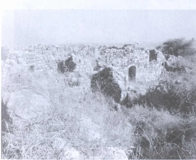
Two archaeological sites lay near the village. They contained building foundations, presses, rock-cut or constructed water cisterns and the remains of an old fortified structure. The available sources do not provide a conclusive date for all these remains.
Occupation and Depopulation of al-Mansura
Al-Mansura was probably attacked and occupied at the end of October 1948 during Operation Hiram, which took place from 28 to 31 October as part of Israel’s occupation of Palestine—the Nakba. Sources generally place the village’s occupation around 31 October or 1 November, but the exact day and the specific brigade responsible have not been conclusively established.
Operation Hiram involved the Carmeli, Oded, Sheva' (Seventh) and Golani brigades. However, participation in the wider operation does not establish that every one of these formations directly entered al-Mansura. Some Palestinian compilations identify the Carmeli Brigade as the probable occupying unit, but this attribution remains uncertain.
The occupation of the area did not immediately complete the village’s depopulation. In mid-November 1948, Israeli forces ordered the inhabitants of Palestinian villages along the Lebanese border, including al-Mansura, to leave their homes. Some residents crossed into Lebanon, while most were transported by truck to al-Rama in Galilee.
In February 1949, the Maronite Church appealed for permission for the displaced inhabitants to return to al-Mansura, but the request was rejected. Villagers who remained inside Palestine continued their legal and public efforts to return for years, without success.
Israeli Settlements and Facilities on the Lands of al-Mansura
- Elkosh was established in 1949 on part of the village’s lands.
- Biranit, initially associated with the name al-Mansura, was established as a military facility on village land in the early 1950s.
- Netu'a was established in 1966 less than one kilometre from the village site, on al-Mansura’s lands.
- Mattat was established on village land in 1979.
- Abirim was established on village land in 1980.
Al-Mansura Today
The village houses were completely demolished, and much of the rubble was pushed into heaps along the northern edge of the site. Iron reinforcing rods remain visible in some of the larger concrete fragments. The site has been enclosed with wire fencing and is used for grazing cattle. A poultry facility belonging to Netu'a stands west of the former village centre.
The only surviving village structure is the Maronite Church of Mari Yohanna, situated approximately 200 metres south of the village site on the mountainside. Its roof and parts of its walls have collapsed. Vineyards have been planted between the church and the village site, while a military airstrip and base occupy the mountaintop to the south.
Sources
- Interactive Encyclopedia of the Palestine Question: al-Mansura, Acre Subdistrict, Institute for Palestine Studies and the Palestinian Museum.
- Interactive Encyclopedia of the Palestine Question: Operation Hiram.
- Palestine Remembered: al-Mansura, Acre Subdistrict.
- Walid Khalidi, ed., All That Remains: The Palestinian Villages Occupied and Depopulated by Israel in 1948, Institute for Palestine Studies, 1992.
- Nafez Nazzal, The Palestinian Exodus from Galilee, 1948, Institute for Palestine Studies, 1978.
- 'Arif al-'Arif, Al-Nakba: Nakbat Bayt al-Maqdis wa-l-Firdaws al-Mafqud, Beirut and Sidon, 1956–1960.
- Government of Palestine, Census of Palestine, 1931.
- Government of Palestine, Department of Statistics, Village Statistics, April 1945.
- Government of Palestine, Palestine Index Gazetteer.
Photo gallery


Photos from the village's people
Photos sent in by visitors and published after review.
Add a photo of this village
Log in to add photos of this village.
Other villages from Akka (Acre)

 Download Our Palestine App
The whole archive in the palm of your hand: depopulated villages, the Nakba, the massacres and Al-Aqsa — free, with no ads to erase the story.
Download Our Palestine App
The whole archive in the palm of your hand: depopulated villages, the Nakba, the massacres and Al-Aqsa — free, with no ads to erase the story.



Comments
No comments yet — be the first to write one.
Add your comment
Name and email are optional. Comments appear after review.