
The depopulated village of Khan al-Duwayr / District of Safed
About the depopulated village of Khan al-Duwayr
- District
- Safed
- Date Khan al-Duwayr was occupied
- 30 May 1948
- Population in 1948
- 302
- Military operation
- Operation Yiftach
- Brigade that carried it out
- Palmach
- Distance from the governorate centre
- 35 (km) North East of Safad
- Elevation above sea level
- 200 m
- Cause of displacement
- Military assault by Zionist troops
- Extent of destruction
- The village has been completely destroyed.
- Ethnic cleansing
- Khan al-Duwayr inhabitants were completely ethnically cleansed.
- Settlements built on the built-up area of Khan al-Duwayr after 1948
- Snir
Hover a dot to read the village name, or click to open its card.
Borders of the depopulated village of Khan al-Duwayr
Khan al-Duwayr – Palestinian Village of the Safad District
Khan al-Duwayr was a Palestinian settlement in the Safad District, located at the extreme northeastern edge of the al-Hula Plain, approximately 35 kilometers northeast of Safad, at an average elevation of about 200 meters above sea level.
The history of its depopulation requires unusual caution because the sources conflict. Mustafa Murad al-Dabbagh and the Palestinian Encyclopedia place the disappearance of the Arab community in 1939, in connection with the establishment of Dan. Walid Khalidi, by contrast, discusses the possibility that the site was attacked during Operation Yiftach in 1948. The official 1945 Village Statistics add a crucial piece of evidence: the statistical unit is listed as “Dan (previously Khan ed Duweir),” with 260 Jews and no Arab population recorded. It is therefore unsafe to present 1948 as the firmly established date on which Khan al-Duwayr's Arab inhabitants were first displaced.
Location and Geography
Khan al-Duwayr stood at the northeastern edge of the al-Hula Plain, overlooking the plain from the south and lying very close to the Syrian frontier and the town of Banyas.
It was approximately 35 kilometers northeast of Safad and stood at an average elevation of about 200 meters above sea level.
A secondary road immediately northwest of the settlement linked it with Banyas, al-Khalisa, and the main road leading toward Safad. Dirt tracks also connected the locality with neighboring villages and agricultural lands.
Supporting Palestinian local documentation places Syrian territory to the north and east, al-Mansura to the south, al-Khisas to the southwest, and al-Shawka al-Tahta to the west and northwest.
Name and Caravanserai
The name Khan al-Duwayr was associated with the khan, or caravanserai, located at the site. The settlement acquired regional importance because it stood along routes used by commercial caravans moving between Syria, Palestine, and Lebanon.
The khan served travelers and merchants, while the settlement's proximity to Banyas, the border, and the al-Hula Plain gave the locality an economic role disproportionate to its small population.
The Settlement in the Nineteenth Century
In the late nineteenth century, Khan al-Duwayr was extremely small. The 1881 Survey of Western Palestine described two stone houses inhabited by approximately twenty Muslims, surrounded by olive trees and cultivable land.
During the British Mandate it was classified as a hamlet in the Palestine Index Gazetteer. Its houses were built of black basalt stone and mud.
Population and Houses
The official 1931 Census of Palestine recorded 137 inhabitants in Khan al-Duwayr, all Muslims, living in 29 houses.
Mustafa Murad al-Dabbagh gives an Arab population of approximately 155 in 1938.
| Year | Population | Note |
|---|---|---|
| Late nineteenth century | About 20 | Historical description, not an official census |
| 1931 | 137 | Official census; all Muslims, living in 29 houses |
| 1938 | About 155 | Figure recorded by Mustafa Murad al-Dabbagh |
| 1945 | No Arabs recorded in the official table | The statistical unit appears as “Dan (previously Khan ed Duweir)” with 260 Jews |
The figure of 260 in the 1945 statistics must not be presented as the Arab population of Khan al-Duwayr. The official Government of Palestine table places the figure in the Jewish population column under “Dan (previously Khan ed Duweir).”
For the same reason, this article does not treat the later figures of approximately 302 inhabitants in 1948 and 1,852 refugees and descendants in 1998 as a secure demographic continuation of the Arab village. Those estimates depend on an online population sequence that treats the 1945 figure in a way that conflicts with the official table.
Education and Religious Buildings
Neither Khalidi's village entry nor the official census and statistical material reviewed here provides firm documentation for an independent school or a specifically identified mosque in Khan al-Duwayr.
No school, mosque, or shrine is therefore added without independent evidence.
Water Resources
The Palestinian Encyclopedia and supporting Palestinian local documentation state that Khan al-Duwayr developed beside Nahr al-'Asal, a tributary of the Banyas River, in a comparatively well-watered region.
The water was used for domestic needs, agricultural irrigation, and livestock. The nineteenth-century description also places the houses near a flowing stream.
Economic Life
The economy combined agriculture with services associated with passing commercial caravans. Khan al-Duwayr was an established stop on routes connecting Syria and Lebanon with Palestine.
Its fertile lands supported cereal cultivation, orchards, irrigated agriculture, and olive trees, which were already mentioned in nineteenth-century descriptions.
Land Ownership, 1944/45
The official 1945 Village Statistics list the cadastral/statistical unit as “Dan (previously Khan ed Duweir).” Its total area was 5,588 dunams.
- Arab2,163 dunums39%
- Jewish3,054 dunums55%
- Public371 dunums7%
The figures balance exactly: 2,163 + 3,054 + 371 = 5,588 dunams.
The digital PalQuest page displays 317 dunams as Public land, which cannot produce the stated total. The reproduced official table in Sami Hadawi gives 371 dunams, and that official figure is used here.
Palestine Remembered's online ownership table for Khan al-Duwayr is visibly corrupted in its present display and has therefore not been used to construct a separate “Palestinian / Transferred to Zionists / Communal/Public” table. No missing figure has been invented.
Land Use, 1944/45
- Arab
- Jewish
- Public
- Plantations and irrigable land4,151 dunums
- Cereals1,026 dunums
- Total cultivable/cultivated land5,177 dunums
- Built-up land40 dunums
- Non-cultivable land371 dunums
The official table balances exactly. It also corrects a second numerical error in the digital PalQuest display, which shows 2,048 Jewish dunams under plantations and irrigable land. The official table gives 2,084 dunams; this is the value required for the plantation total of 4,151 and the Jewish land total of 3,054 dunams.
Tall al-Qadi and Archaeology
Tall al-Qadi lies approximately one kilometer northwest of the Khan al-Duwayr site and is one of the major archaeological locations in the region.
Walid Khalidi cautiously associates the tell with ancient Laish, later known as Dan, while Mustafa Murad al-Dabbagh refers to the Roman-period settlement of Danus in the same general area.
These identifications should be understood as historical and archaeological interpretations rather than as evidence that all remains at the site belong to a single period.
Khan al-Duwayr and the Establishment of Dan in 1939
This is the central source dispute in the village's history. Mustafa Murad al-Dabbagh, as reproduced by the Palestinian Encyclopedia, classifies Khan al-Duwayr among Arab villages that disappeared during the Mandate period and states that Dan was established in the vicinity in 1939 and that the Arab inhabitants were displaced.
The official 1945 statistics give significant support to the conclusion that the Arab residential community had already disappeared by then: they list the unit as “Dan (previously Khan ed Duweir),” record 260 Jews and no Arabs, while still recording 2,163 dunams of Arab-owned land.
Walid Khalidi, however, gives a different cadastral interpretation. He places Dan approximately two kilometers west of the Khan al-Duwayr site and states that no Israeli settlement was established on the village's lands.
The relationship between Dan and Khan al-Duwayr therefore cannot be reduced to a single unqualified statement. What is certain is that the official 1945 population table no longer records an Arab population in the statistical unit formerly called Khan ed Duweir.
Operation Yiftach and the Site in 1948
Operation Yiftach lasted from 15 April to 25 May 1948 and was conducted by Palmach forces in eastern Galilee under Plan Dalet. The Palmach's First Battalion spearheaded the operation at the general operational level.
PalQuest includes Khan al-Duwayr among the localities affected by Operation Yiftach, but Khalidi gives no confirmed date for an attack or entry into the site. He suggests that it may have been targeted in the second half of April because of its border location and accessibility from nearby Dafna, or that Zionist forces may not have physically entered it until late May.
Palestine Remembered indexes 30 May 1948 and identifies the Palmach's First Battalion. However, 30 May falls after Operation Yiftach's official end date of 25 May. If this indexed date is used at all, it should therefore be described as occurring in the aftermath of the operation rather than within it.
More importantly, the official 1945 census table records no Arab inhabitants in Khan al-Duwayr. It is therefore impossible to establish from the evidence reviewed here that a 1948 military action was the event that first depopulated the Arab community. Such an action may instead have concerned military control of the site and its lands after the Arab residential population had already disappeared.
The Demilitarized Zone after 1949
Following the Syrian–Israeli General Armistice Agreement of July 1949, the Khan al-Duwayr sector lay within the northern section of the demilitarized zone along the Syrian–Palestinian frontier.
Palestinian local documentation likewise lists Khan al-Duwayr among the villages and lands associated with the demilitarized zone.
The sources reviewed here, however, do not establish securely that the original inhabitants of Khan al-Duwayr themselves returned to this particular settlement and remained there until 1967. For this reason, the 1967 occupation date appearing in one Palestinian database is not adopted as the definitive depopulation date without stronger village-specific evidence.
Occupation and Depopulation Chronology
- 1931
Last clear official Arab census
137 Muslims living in 29 houses.
- 1938
Al-Dabbagh's population estimate
Approximately 155 Arab inhabitants.
- 1939
Establishment of Dan
Al-Dabbagh and the Palestinian Encyclopedia associate its establishment with the displacement of Khan al-Duwayr's Arab residents; Khalidi gives a different cadastral interpretation and places Dan west of the village site.
- 1945
Government of Palestine statistics
The unit is listed as “Dan (previously Khan ed Duweir),” with 260 Jews and no Arabs, while 2,163 dunams remained Arab-owned.
- 15 April 1948
Beginning of Operation Yiftach
Palmach forces began the campaign to take control of eastern Galilee.
- Second half of April 1948
Possible attack on the Khan al-Duwayr site
Khalidi considers an early Yiftach attack possible but does not establish a precise date.
- 25 May 1948
End of Operation Yiftach
Official end date of the operation.
- 30 May 1948
Later indexed date for control of the site
Used by Palestine Remembered, but it falls after Yiftach and cannot safely be treated as the confirmed date of the Arab population's original displacement.
- July 1949
Demilitarized zone
The Khan al-Duwayr sector became part of the northern Syrian–Israeli demilitarized zone.
- Exact date not documented
Destruction of the remaining structures
The principal sources reviewed do not provide a secure date for the destruction of all village buildings.
Israeli Settlements and Village Lands
According to Walid Khalidi's cadastral assessment, no Israeli settlement was established directly on Khan al-Duwayr's village lands.
Dan, established in 1939, lay approximately two kilometers west of the village site according to Khalidi, while Dafna, established the same year, lay approximately three kilometers to the southwest.
The source discrepancy must nevertheless remain explicit: al-Dabbagh directly associates Dan's establishment with the disappearance of Khan al-Duwayr's Arab community, and the official 1945 statistics rename the unit “Dan (previously Khan ed Duweir).” The historical relationship between the two is therefore undeniable even if Khalidi's cadastral reconstruction places Dan outside Khan al-Duwayr's village lands.
Khan al-Duwayr Today
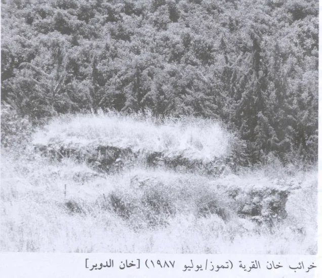
According to the field description published in Walid Khalidi's All That Remains, the site was deserted and overgrown with grass. Only the ruins of the khan, or caravanserai, remained visibly identifiable.
The surrounding lands were used for cultivation and grazing, while other areas had become forested.
This description should not be treated as a field verification of conditions in 2026. Fieldwork for All That Remains was carried out between 1987 and 1990. The account therefore documents the state of the site during that survey period; the principal Palestinian sources reviewed here do not provide a comprehensive current field survey of all surviving remains.
Sources
- PalQuest – Interactive Encyclopedia of the Palestine Question: Khan al-Duwayr
- PalQuest – Operation Yiftach
- Palestinian Encyclopedia – Arab Villages That Disappeared Before 1948: Khan al-Duwayr
- Palestinian Encyclopedia – Tall al-Qadi
- Palestine Remembered – Khan al-Duwayr, Safad District
- Sami Hadawi – Village Statistics 1945, official Safad Sub-District tables
- Census of Palestine 1931
- Palestinian Villages Encyclopedia – Khan al-Duwayr; supporting Palestinian local documentation
- Institute for Palestine Studies – Walid Khalidi, All That Remains
- PalQuest – All That Remains: Methodology
Photo gallery


Photos from the village's people
Photos sent in by visitors and published after review.
Add a photo of this village
Log in to add photos of this village.
Other villages from Safed


More from the archive



 Download Our Palestine App
The whole archive in the palm of your hand: depopulated villages, the Nakba, the massacres and Al-Aqsa — free, with no ads to erase the story.
Download Our Palestine App
The whole archive in the palm of your hand: depopulated villages, the Nakba, the massacres and Al-Aqsa — free, with no ads to erase the story.



Comments
No comments yet — be the first to write one.
Add your comment
Name and email are optional. Comments appear after review.