
The depopulated village of Qadas / District of Safed

About the depopulated village of Qadas
- District
- Safed
- Date Qadas was occupied
- 28 May 1948
- Population in 1948
- 450
- Military operation
- Operation Yiftach
- Who defended the village
- Lebanese Army & Arab Liberation Army
- Distance from the governorate centre
- 17 (km) North East of Safad
- Elevation above sea level
- 245 m
- Cause of displacement
- Influence of fall of, or exoduce from, neighboring town
- Extent of destruction
- The village has been completely destroyed, and only house walls and rubble left behind.
- Ethnic cleansing
- Qadas inhabitants were completely ethnically cleansed.
- Settlements built on the built-up area of Qadas after 1948
- Yiftach
Hover a dot to read the village name, or click to open its card.
Borders of the depopulated village of Qadas
Qadas: A Depopulated Palestinian Village in the Safad District
Qadas was a Palestinian village in the Safad District, situated in Upper Galilee near the Palestine–Lebanon frontier, approximately 17 km from Safad and at an average elevation of about 475 metres above sea level. The village stood on a plateau at the edge of a small wadi containing a spring and depended principally on agriculture, especially cereals, fruit, and olives. During the Nakba and the occupation of Palestine in 1948, control of Qadas changed hands repeatedly between May and October. The village was finally occupied in late October during Operation Hiram after Lebanese forces had retaken it in June.
Location of Qadas
Qadas stood on a plateau at the edge of a small wadi through which a spring flowed, in the mountainous landscape of Upper Galilee near the Lebanese frontier.
It was approximately 17 km from Safad. PalQuest gives its average elevation as about 475 metres above sea level.
Palestine Remembered's statistical header gives 245 metres; because the two sources differ, this article follows the 475-metre figure in PalQuest.
A secondary road running through neighboring al-Nabi Yusha' connected Qadas with the main road leading to Safad.
Neighboring Villages and Lands
Qadas was surrounded by Palestinian villages and lands close to the Lebanese frontier.
- To the north: lands of al-Buwayziyya and the Lebanese frontier zone.
- To the northeast: Jahula.
- To the east: al-Nabi Yusha'.
- To the southeast: Harrawi / 'Arab al-Hamdun.
- To the south: Dayshum.
- To the west and southwest: al-Malikiyya and Lebanese lands.
Palestine Remembered's nearby-localities map also places Taytaba in the broader northeastern vicinity, while its list of cadastral neighbors emphasizes al-Buwayziyya, Jahula, al-Nabi Yusha', Harrawi, Dayshum, al-Malikiyya, and Lebanese lands.
The Name and Historical Background of Qadas
Palestine Remembered associates the site with ancient Canaanite Qadesh. PalQuest does not present the same etymological identification as a definitive linguistic conclusion, but it clearly documents the exceptional antiquity of settlement in the area.
Archaeological and epigraphic evidence indicates that an important Roman and Byzantine town stood just east of the modern Palestinian village.
Excavations uncovered a Roman temple dating to the first and second centuries CE.
During the early Islamic period, Qadas was a town in the province of Jordan.
The geographer al-Muqaddasi, writing in 985 CE, described it as a small and prosperous town on a green mountainside, with three springs and a bath below it and a mosque and palm tree in its marketplace.
Qadas in the Ottoman Period
In 1596, Qadas was a village in the nahiya of Tibnin within the liwa of Safad and had an estimated population of approximately 319.
The inhabitants paid taxes on wheat, barley, olives, and cotton, as well as goats, beehives, orchards, and a press used for processing olives or grapes.
In the late nineteenth century, Qadas was described as a stone-built village on the spur of a ridge, with an estimated population of between 100 and 300. The villagers cultivated figs and olives.
Qadas and the Palestine–Lebanon Boundary
Qadas remained part of Lebanon until 1923, when the final Lebanon–Palestine boundary was delineated and the village became part of Mandatory Palestine and the Safad Sub-District.
For this reason, no 1922 Palestine census figure is presented for Qadas: at the time of that census, the village had not yet been incorporated into Mandatory Palestine.
Architecture of Qadas
Qadas was principally a stone-built village with a relatively compact residential core on the plateau.
The official 1931 census recorded 56 occupied houses.
The 1944/45 statistics record a combined built-up area of 39 dunums for the statistical unit that included Qadas and Bulayda: 20 Arab dunums and 19 Jewish dunums.
The 39-dunum figure should therefore not be presented as the built-up area of the Palestinian village of Qadas alone without noting the inclusion of Bulayda.
Water Resources
Water was one of the principal foundations of life and agriculture in Qadas.
The village stood beside a small wadi containing a spring, and the inhabitants used its water for drinking and domestic needs.
Rainfall and nearby springs were abundant enough to support an agricultural economy based on cereals, fruit, and olives.
Al-Muqaddasi's tenth-century description of three springs and a bath also reflects the long historical importance of water at the site.
Education and Public Facilities
Khalidi's principal PalQuest entry does not provide sufficiently documented information about a modern independent village school in Qadas during the final years of the Mandate, so no unsupported enrollment or founding date is added.
The historical source records a mosque in the marketplace of early Islamic Qadas, but that tenth-century description should not automatically be treated as documentation of the precise form of the twentieth-century village mosque.
An olive press is clearly documented as an economic facility in the modern village.
Population of Qadas
The official 1931 Census of Palestine recorded 273 inhabitants living in 56 houses.
The official census table records 272 Muslims and one Christian, while Khalidi's general narrative describes the inhabitants as Muslim.
In 1944/45, the official population was 390, but the statistical figure included Bulayda together with Qadas and therefore cannot be treated as a separate population count for Qadas alone.
Population of Qadas in selected years
- 1596Approximately 319Estimate derived from Ottoman records
- Late nineteenth centuryApproximately 100–300Historical estimate
- 1931273Official census: 272 Muslims and one Christian
- 1944/45390Official statistics; includes Bulayda
- 1948452Later estimate published by Palestine Remembered; not an official Mandate census
- Estimated refugees in 19982,778Later estimate published by Palestine Remembered
Number of Houses
Number of houses in Qadas
- 193156Official British Mandate census
- 194892Later estimate published by Palestine Remembered
Economic Life in Qadas
Agriculture was the principal source of livelihood.
Cereals, fruit, and olives were among the principal crops, and abundant rainfall and springs supported a relatively strong agricultural economy.
In the 1942/43 season, approximately 286 dunums were planted with productive olive trees.
In the 1944/45 statistics, 5,709 Arab dunums were devoted to cereals and 156 Arab dunums were irrigated or used for plantations, together with additional land recorded in the Jewish category.
The village also had an olive press.
The 286-dunum olive figure refers to the 1942/43 season and should not be added again to the later 1944/45 land-use totals.
Land Ownership in Qadas
The total registered land area of the Qadas–Bulayda statistical unit was 14,139 dunums in 1944/45.
Land ownership in Qadas and Bulayda, 1944/45, using Palestine Remembered's ownership terminology
- Palestinian10,644 dunums75%
- Transferred to Zionists3,491 dunums25%
- Communal/Public4 dunums<1%
Palestinian land represented approximately 75.3 percent of the total statistical unit, land in the category “Transferred to Zionists” approximately 24.7 percent, and public/communal land only four dunums.
These official figures include Bulayda together with Qadas.
Land Use in Qadas, 1944/45
The official detailed land-use tables use the source categories Arab, Jewish, and Public. Those categories are preserved below.
Land use in the combined Qadas–Bulayda statistical unit, 1944/45
- Arab
- Jewish
- Public
- Plantations and irrigable land321 dunums
- Cereals9,016 dunums
- Built-up area39 dunums
- Non-cultivable land4,763 dunums
Cultivated or cultivable land totaled 9,337 dunums, approximately 66 percent of the registered area.
Built-up and non-cultivable land together amounted to 4,802 dunums, approximately 34 percent.
Palestine Remembered's simplified table places all 4,763 dunums of non-arable land in the Palestinian column. The detailed official statistics show that 4,759 dunums were Arab land and four dunums were public land.
All of these 1944/45 figures include Bulayda together with Qadas.
Archaeology of Qadas
Qadas was one of the most archaeologically significant locations in northern Palestine.
Archaeological and epigraphic evidence indicates that an important Roman and Byzantine town existed east of the Palestinian village.
Excavations uncovered the remains of a Roman temple dating to the first and second centuries CE.
Palestine Remembered additionally records Khirbat Qadas, including a mound of ruins, burials, foundations, architectural fragments, and decorated sarcophagi, together with Khirbat al-Mahafir.
These ancient remains should be distinguished from the modern Palestinian village that remained inhabited until the Nakba.
Operation Yiftach and the First Attack on Qadas
After Safad fell on 11 May 1948, forces participating in Operation Yiftach were ordered to advance northward.
On the night of 14–15 May, the Palmach's First Battalion advanced toward Qadas and neighboring al-Malikiyya.
The account reproduced by Khalidi states that Qadas was taken by the attacking force by morning.
Lebanese units crossed the frontier later that day and launched a major counterattack, forcing the Palmach to withdraw from Qadas.
The Lebanese advance stopped in the Qadas–al-Malikiyya sector, and the Lebanese army remained in Qadas for approximately two weeks.
The 28–29 May 1948 Recapture
After Operation Yiftach formally ended on 25 May, Zionist forces mounted another operation on 28–29 May to regain Qadas and al-Malikiyya.
Khalidi reproduces an account of a military deception in which an armored column entered Lebanon by another route and then returned southward toward al-Malikiyya, creating the appearance of Lebanese reinforcements.
With the area surrounded, Qadas and al-Malikiyya again fell to the attacking forces.
This explains why 28 May appears in some summary tables as Qadas's “occupation date,” but it was not the village's final occupation.
Lebanese Recapture on 7 June
Zionist control of Qadas again proved temporary.
Lebanese forces regrouped and recaptured al-Malikiyya first, followed by Qadas on 7 June 1948.
The Qadas sector once again served as an entry route for Arab forces coming from Lebanon.
Khalidi considers it possible that Lebanese and Arab Liberation Army units remained in Qadas through the summer and beyond the second truce.
Operation Hiram and the Final Occupation of Qadas
Operation Hiram began in late October 1948 and targeted the remaining areas of Upper Galilee outside Israeli control.
Qadas was among the villages affected by the operation.
Khalidi states that Qadas fell again to Israeli occupation forces in late October, probably at approximately the same time as neighboring al-Malikiyya.
The dedicated Qadas entry does not establish an exact final day or a single village-specific Israeli battalion responsible for the final assault, so no unsupported unit attribution is made.
Twenty-eight May should therefore not be treated as Qadas's final occupation date. The historically more accurate formulation is late October 1948 during Operation Hiram.
When Did the Villagers Leave?
The precise date on which the inhabitants of Qadas left is not known.
Khalidi reproduces circumstantial evidence suggesting that the villagers may have been displaced by the first assault of 14–15 May 1948.
Because military control of Qadas changed repeatedly between May, June, and October, the date of civilian displacement should not automatically be equated with any one military occupation date.
The most cautious formulation is that the population may have been displaced during the first May attack, while the struggle for control of the village continued until its final occupation during Operation Hiram in late October.
- 14–15 May 1948: Palmach First Battalion attack and temporary capture of Qadas.
- 15 May: Lebanese counterattack forces the Palmach to withdraw.
- Approximately 15–28 May: Lebanese army presence in Qadas.
- 28–29 May: Qadas and al-Malikiyya recaptured by Zionist forces using a military deception.
- 7 June: Lebanese forces retake Qadas.
- Summer and second truce: probable Lebanese and Arab Liberation Army presence.
- 28–31 October: Operation Hiram.
- Late October: final occupation of Qadas, probably around the same period as al-Malikiyya.
- Date of civilian departure: uncertain; possibly during the first assault of 14–15 May.
Israeli Settlements on Qadas Lands
Yiftach was established in 1948 on Qadas land northeast of the former village site.
Malkiyya and Ramot Naftali also use parts of Qadas's lands.
- Yiftach: established in 1948 on Qadas land, northeast of the village site.
- Ramot Naftali: established in 1945 and uses parts of Qadas's lands.
- Malkiyya: established in 1949 and uses parts of Qadas's lands.
The Arabic Palestine Remembered page contains an erroneous founding year for Malkiyya in one passage. PalQuest gives the settlement's founding year as 1949.
Qadas Today
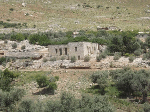
According to the field description published by Walid Khalidi in All That Remains, stones from the destroyed Palestinian houses were scattered across the fenced former village site.
Several partially ruined walls near the spring remained visible.
Mulberry, fig, eucalyptus, and cactus plants grew across the site.
The flat portions of the surrounding land were planted with apple trees, while the spring provided drinking water for livestock at the time of Khalidi's documentation.
Palestine Remembered preserves later community documentation, including photographs taken on 7 May 2005 showing the spring channel, a water-collection pool, and surviving remains.
The site also preserves photographs explicitly dated 3 May 2014, including one captioned as showing 'Ayn Qadas dry on that date, together with photographs of Roman remains and the destroyed village.
On 17 June 2025, a series of community-contributed images described as a tour among the remains on Qadas land was uploaded, and a historical map was uploaded on 29 September 2025.
The 2025 upload dates do not necessarily establish when every photograph was taken and do not constitute a comprehensive independent contemporary field survey.
Khalidi's 1992 publication therefore remains the principal systematic field description used here, supplemented cautiously by later community material. The approved sources do not provide a sufficiently comprehensive independent 2026 survey to establish the precise condition of every part of Qadas today.
Sources
- PalQuestPalQuest – Interactive Encyclopedia of the Palestine Question: Qadas
- PalQuestPalQuest – Operation Yiftach
- PalQuestPalQuest – Operation Hiram
- Palestine RememberedPalestine Remembered – Qadas, Safad District
- Palestine RememberedPalestine Remembered – Qadas entry from All That Remains
- maktabatsabil.comVillage Statistics 1945 – Population and Land Ownership, Safad Sub-District
- sabil.meVillage Statistics 1945 – Cultivable Land
- sabil.meVillage Statistics 1945 – Built-up and Non-Cultivable Land
- Institute for Palestine StudiesInstitute for Palestine Studies – All That Remains, Walid Khalidi
Photo gallery


Photos from the village's people
Photos sent in by visitors and published after review.
Add a photo of this village
Log in to add photos of this village.
Other villages from Safed


More from the archive



 Download Our Palestine App
The whole archive in the palm of your hand: depopulated villages, the Nakba, the massacres and Al-Aqsa — free, with no ads to erase the story.
Download Our Palestine App
The whole archive in the palm of your hand: depopulated villages, the Nakba, the massacres and Al-Aqsa — free, with no ads to erase the story.



Comments
No comments yet — be the first to write one.
Add your comment
Name and email are optional. Comments appear after review.