
The depopulated village of Ghabbatiyya / District of Safed
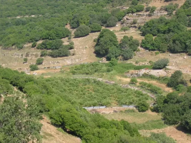
Ghabbatiyya
About the depopulated village of Ghabbatiyya
- District
- Safed
- Date Ghabbatiyya was occupied
- 30 October 1948
- Population in 1948
- 70
- Military operation
- Operation Hiram
- Brigade that carried it out
- The Seventh Brigade
- Who defended the village
- Local militia & Arab Liberation Army
- Distance from the governorate centre
- 12 (km) North West of Safad
- Elevation above sea level
- 875 m
- Cause of displacement
- Military assault by Zionist troops
- Extent of destruction
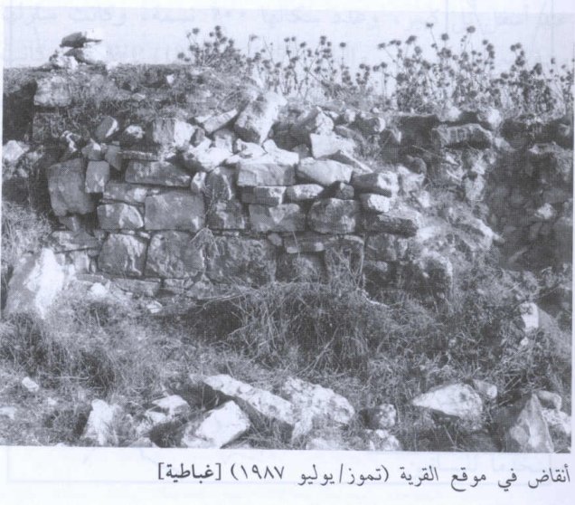
- The village has been completely destroyed, and only house rubble left behind.
- Ethnic cleansing
- Ghabbatiyya inhabitants were completely ethnically cleansed.
- Settlements built on the built-up area of Ghabbatiyya after 1948
- Sde Meron School
Hover a dot to read the village name, or click to open its card.
Borders of the depopulated village of Ghabbatiyya
Ghabbatiyya – Depopulated Palestinian Hamlet in Safad Subdistrict
Ghabbatiyya was a Palestinian hamlet in the Safad subdistrict of Upper Galilee. It stood approximately 12 kilometers northwest of Safad at an average elevation of about 875 meters above sea level.
The hamlet occupied a rocky hill between Mount al-Jarmaq, approximately 1,208 meters high, and Mount 'Adathir, approximately 1,009 meters high. It lay about two kilometers east of the Druze village of Hurfaysh.
The Mandate-era Palestine Index Gazetteer classified Ghabbatiyya as a farm or hamlet. Its official 1944/45 population was 60 Arab Muslims, and its registered land area was 2,933 dunums.
Ghabbatiyya was occupied on 30 October 1948 during the second phase of Operation Hiram, as Israeli forces advancing from the eastern and western fronts converged in a large pincer movement around neighboring Sa'sa'.
Key Facts about Ghabbatiyya
| Field | Information |
|---|---|
| Name | Ghabbatiyya |
| Subdistrict | Safad |
| Distance from Safad | Approximately 12 km northwest |
| Average elevation | Approximately 875 m above sea level |
| Mandate classification | Farm / hamlet |
| Population, 1922 | 9 Muslims |
| Population, 1931 | No independently documented figure identified in the principal sources used |
| Population, 1944/45 | 60 Arab Muslims |
| Registered land area | 2,933 dunums |
| Occupation date | 30 October 1948 |
| Military operation | Operation Hiram – second phase |
| Military unit | Seventh/Sheva' Brigade is probable and is attributed by Palestinian secondary sources; Khalidi's village entry does not explicitly identify the direct village-level unit |
| Defenders | Arab Liberation Army forces in the wider area; no independent village-specific garrison strength is established |
| Cause of depopulation | Military occupation during Operation Hiram; Palestine Remembered classifies the cause as direct military assault |
| Extent of destruction | Most of the built-up hamlet was destroyed; ruins and walls of one demolished house remained |
| Israeli settlements on village land | None documented |
Name of the Village
The village is recorded in Palestinian sources as Ghabbatiyya.
Some Palestinian local-history sources suggest that the name may derive from a Syriac expression meaning a densely wooded place.
This remains a proposed linguistic interpretation rather than a firmly established historical etymology in Khalidi's village entry.
Location
Ghabbatiyya stood in the mountains of Upper Galilee on a rocky hill between Mount al-Jarmaq and Mount 'Adathir.
It was approximately two kilometers east of Hurfaysh. Local Palestinian geographical documentation places Sa'sa' to the north, Safsaf to the east, Hurfaysh to the west, Sabalan to the southwest, and Bayt Jann to the south.
The village extended generally east–west along the northern side of a secondary road linking it with neighboring communities.
This road connected with larger roads leading toward Safad and the Mediterranean coast.
Village Layout
Ghabbatiyya was a small, relatively compact settlement with an east–west rectangular orientation.
Its Mandate classification as a hamlet reflects the small size of its built-up nucleus in comparison with larger villages in the Safad district.
The 1944/45 land-use table does not provide a separate built-up acreage, so no independent built-up figure has been inferred.
Population
| Year | Population | Nature of Figure |
|---|---|---|
| 1922 | 9 | Official British Mandate census; all Muslims |
| 1931 | Not independently available | No separate documented figure identified in the principal sources used |
| 1944/45 | 60 | Official Department of Statistics estimate; all Arab Muslims |
| 1948 | 70 | Later Palestine Remembered estimate, not an official census |
| 1998 | 427 | Later estimate of refugees and descendants, not an official census |
Ghabbatiyya was among the smallest Palestinian communities in the Safad subdistrict by population.
The 1948 and 1998 figures are later estimates and should not be attributed to British Mandatory census statistics.
Number of Houses
No independently documented house count for Ghabbatiyya in 1931 or 1948 was identified in the principal sources reviewed.
No estimate has therefore been inferred from population totals or historical photographs.
Land Ownership
The total registered village land area in 1944/45 was 2,933 dunums.
- Palestinian / Arab2,381 dunums81%
- Transferred to Zionists0 dunums0%
- Communal/Public552 dunums19%
The figures balance exactly: 2,381 + 552 = 2,933 dunums.
A figure of 3,453 dunums appears in some secondary webpages. The underlying 1945 statistical table and PalQuest, however, list Ghabbatiyya with 2,381 Arab dunums and 552 Public dunums, for a correct total of 2,933 dunums.
Land Use in 1944/45
- Arab
- Public
- Cereals412 dunums
- Plantations and irrigable land15 dunums
- Non-cultivable land2,506 dunums
The land-use figures balance exactly:
412 + 15 + 2,506 = 2,933 dunums.
No separate built-up acreage appears in the table used by PalQuest.
Correction to the Cereal Figure
The version of Khalidi's text reproduced on Palestine Remembered contains the number 421 dunums for cereal cultivation.
PalQuest and the statistical table give 412 dunums, which is also the number required for the totals to balance:
412 + 15 + 2,506 = 2,933 dunums.
This article therefore uses 412 dunums as the consistent official figure.
Economic Life
Agriculture and livestock raising formed the basis of Ghabbatiyya's economy.
In 1944/45, 412 dunums were devoted to cereals and 15 dunums to irrigated cultivation or orchards.
The mountainous terrain, seasonal wadis, and access to springs and wells also supported animal husbandry.
Water Resources and Wadis
Three wadis passed close to the village, supplying water during the rainy season and contributing usable agricultural ground during the dry season.
Local Palestinian geographical sources identify Wadi al-Marran south of the village, Wadi al-Manba' farther south, and Wadi Khallat Zawana to the north.
Wadi al-Marran and Wadi al-Manba' joined near the southern edge of the village lands and became part of a drainage system eventually flowing toward Wadi al-Qarn.
A well stood near the northwestern edge of the village, while springs southeast of the village included 'Ayn Ghabbatiyya, 'Ayn al-Khayra or al-Khubayza, 'Ayn al-'Arr, and Bir al-Sukkar according to local Palestinian documentation.
Khalidi's core village description confirms three nearby wadis and additional springs and wells but does not provide the full list of names.
Education and Public Services
Khalidi and PalQuest do not independently document a village school, founding date, or enrollment figure for Ghabbatiyya.
The principal village entry likewise does not identify a mosque, market, or other formal public institution.
Given the small size of the hamlet, institutions from neighboring communities should not be attributed to Ghabbatiyya without direct evidence.
Archaeological Remains
The Ghabbatiyya area contained remains of earlier settlement.
In 1881 the Survey of Western Palestine recorded foundations of walls and an olive press at Khirbat Ghabbatiyya.
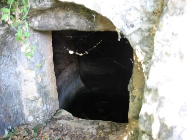
Palestinian local-history sources additionally record a pool, cisterns, caves, rock-cut tombs, and a square rock-cut basin near 'Ayn Ghabbatiyya.
Nearby Khirbat al-Tannuriyya reportedly contained foundations, stone heaps, and a cistern, while Khirbat al-Humayma lay to the east.
The sources reviewed do not securely date all these remains, so they have not been assigned collectively to a single archaeological period.
Operation Hiram
Operation Hiram began on 28 October 1948 and ended on 31 October.
It targeted the last large Arab-held pocket in Upper Galilee after the second truce.
At the campaign level, forces from the Sheva'/Seventh, Carmeli, Golani, and 'Oded brigades participated, while PalQuest's operation data also list Giv'ati.
The offensive employed a broad pincer movement in which forces advanced from eastern, western, and southern axes toward the strategically important Sa'sa' road junction.
Occupation and Depopulation
Ghabbatiyya was occupied on 30 October 1948 during the second phase of Operation Hiram.
At approximately noon that day, forces advancing from the eastern and western fronts converged in a pincer movement around neighboring Sa'sa'.
The following day an Israeli military spokesman, cited in the contemporary report reproduced by Khalidi, said that several hundred members of the Arab Liberation Army garrison in the wider area had been killed and several hundred captured.
Those figures refer to the regional Arab Liberation Army force during Operation Hiram and should not be interpreted as casualty totals for Ghabbatiyya itself.
Military Unit
Palestine Remembered and some Palestinian secondary sources attribute Ghabbatiyya's occupation to the Seventh Brigade, also known as the Sheva' Brigade.
This attribution is geographically consistent with the Seventh Brigade's advance toward Sa'sa' during Operation Hiram.
Khalidi's Ghabbatiyya entry, however, does not explicitly name the battalion or brigade that entered the hamlet and instead places its occupation within the convergence of the two operational fronts around Sa'sa'.
The most accurate formulation is therefore: the Seventh/Sheva' Brigade is probable and is attributed by Palestinian secondary sources, but the direct village-specific unit is not explicitly identified in Khalidi's Ghabbatiyya entry.
Cause of Depopulation
Khalidi does not provide a separate detailed account establishing whether Ghabbatiyya's residents fled immediately before the occupation or were directly expelled after forces entered the hamlet.
The village nevertheless fell during Operation Hiram, an offensive that produced widespread flight and expulsions throughout Upper Galilee.
Palestine Remembered classifies Ghabbatiyya's cause of depopulation as direct military assault.
No undocumented village-specific written expulsion order has therefore been added.
Ethnic Cleansing
Palestine Remembered characterizes the final outcome at Ghabbatiyya as complete ethnic cleansing.
Khalidi documents the occupation and complete depopulation of the hamlet during Operation Hiram but does not provide an independent detailed account of the precise mechanism by which every resident left.
The term “ethnic cleansing” is therefore retained as an attributed characterization used by Palestine Remembered, while the directly documented outcome is the disappearance of Ghabbatiyya's Palestinian community following its occupation.
Occupation Chronology
- 28 October 1948
Beginning of Operation Hiram
The large-scale offensive against the remaining Arab-held pocket in Upper Galilee began.
- 28–29 October 1948
First phase
Israeli forces advanced on several axes and occupied villages and positions across Upper Galilee.
- 30 October 1948
Second phase
The pincer maneuver continued toward Sa'sa' as eastern and western forces converged.
- 30 October 1948
Occupation of Ghabbatiyya
The hamlet was occupied as the operational fronts converged around neighboring Sa'sa'.
- 30 October 1948
Probable military formation
Seventh/Sheva' Brigade according to Palestinian secondary sources; Khalidi's village entry does not explicitly identify the direct unit.
- During the occupation
Depopulation
The Palestinian community disappeared from the hamlet; the precise village-specific mechanism of departure is not independently documented.
- 31 October 1948
End of Operation Hiram
The operation ended after Israeli forces gained control of most of Upper Galilee.
- Precise demolition date not documented
Destruction
Most village buildings were destroyed; portions of one ruined house and other stone remains survived.
Israeli Settlements on Ghabbatiyya's Lands
Khalidi and PalQuest explicitly state that no Israeli settlement was established on Ghabbatiyya's village lands.
Settlements or other facilities in the surrounding region should therefore not be attributed to Ghabbatiyya without independent cadastral evidence.
Ghabbatiyya Today
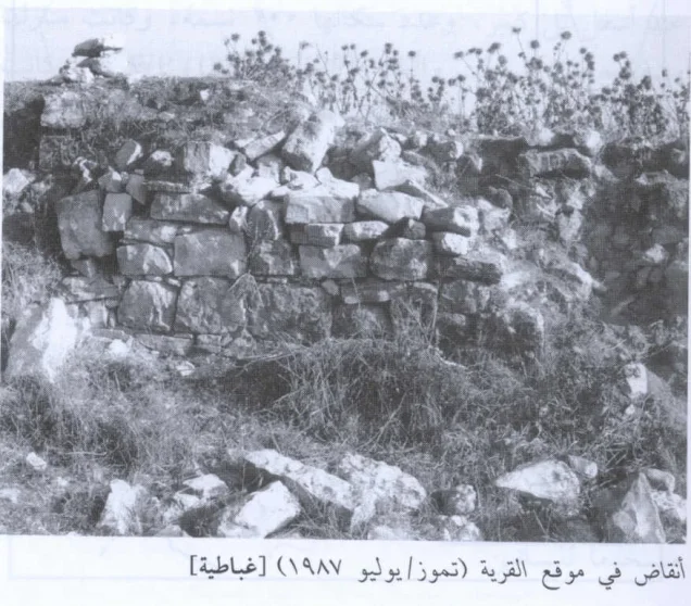
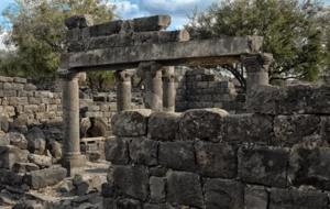
According to Walid Khalidi's field description, the former village site was deserted and covered with grass, stones, and the ruins of stone houses.
A few fig trees remained, and the walls of one demolished house were still standing.
The surrounding lands were used for grazing, while forests covered nearby Mount 'Adathir.
The site photograph reproduced by PalQuest and Khalidi is dated July 1987. The description therefore documents the site's historical condition during fieldwork undertaken before the publication of All That Remains in 1992 rather than providing comprehensive direct field verification for 2026.
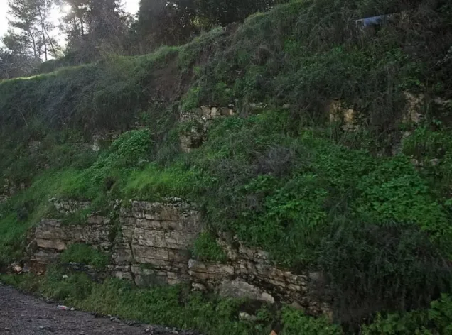
Later community documentation includes photographs from 2003 showing house ruins, stone remains, and rock-cut tomb entrances. These materials provide useful later evidence of individual surviving features but do not constitute a comprehensive archaeological survey of all village lands.
Sources
- PalQuest – Interactive Encyclopedia of the Palestine Question: Ghabbatiyya.
- PalQuest – Operation Hiram.
- Palestine Remembered – Ghabbatiyya, Safad District.
- Walid Khalidi – All That Remains: The Palestinian Villages Occupied and Depopulated by Israel in 1948.
- Institute for Palestine Studies – All That Remains.
- Government of Palestine – Village Statistics 1945.
- Government of Palestine – Census of Palestine 1922.
- Survey of Western Palestine – archaeological description of Khirbat Ghabbatiyya.
- Palestinian Villages Encyclopedia – Ghabbatiyya, drawing on Mustafa Murad al-Dabbagh, Walid Khalidi, and additional Palestinian sources.
Photo gallery

Photos from the village's people
Photos sent in by visitors and published after review.
Add a photo of this village
Log in to add photos of this village.
Other villages from Safed

More from the archive


 Download Our Palestine App
The whole archive in the palm of your hand: depopulated villages, the Nakba, the massacres and Al-Aqsa — free, with no ads to erase the story.
Download Our Palestine App
The whole archive in the palm of your hand: depopulated villages, the Nakba, the massacres and Al-Aqsa — free, with no ads to erase the story.



Comments
No comments yet — be the first to write one.
Add your comment
Name and email are optional. Comments appear after review.