
The depopulated village of Mallaha / District of Safed
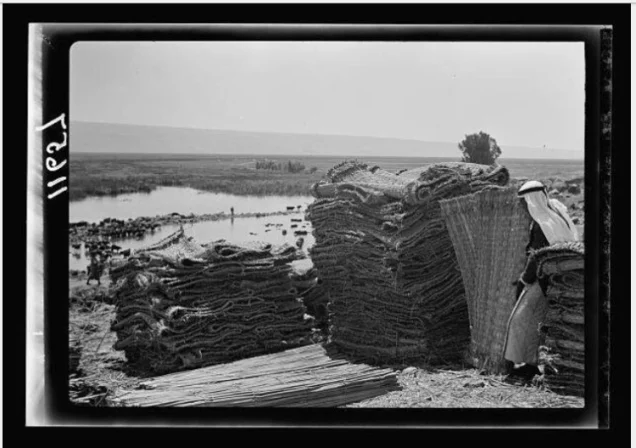
Mallaha
About the depopulated village of Mallaha
- District
- Safed
- Date Mallaha was occupied
- 25 May 1948
- Military operation
- Operation Yiftach
- Brigade that carried it out
- Not identified in the sources; Operation Yiftach was carried out by the Palmach's Yiftach Brigade, spearheaded by its First Battalion
- Distance from the governorate centre
- 16 km northeast of Safad
- Elevation above sea level
- 75 m
- Cause of displacement
- A campaign of psychological warfare by Zionist forces to induce the inhabitants to flee; a direct military assault, possibly including mortar fire, cannot be ruled out, according to Khalidi
- Extent of destruction
- The village has been completely destroyed.
- Ethnic cleansing
- Mallaha inhabitants were completely ethnically cleansed.
- Settlements built on the built-up area of Mallaha after 1948
- No Israeli settlements on village lands, according to Khalidi (PalQuest); Yesud ha-Ma'ala, founded in 1883, lies some 5 km to the southeast of the site
Hover a dot to read the village name, or click to open its card.
Borders of the depopulated village of Mallaha
Mallaha: A Depopulated Palestinian Village in the Safad District
Mallaha was a depopulated Palestinian village in the Safad District, located approximately 16 kilometers from the city of Safad at an average elevation of about 75 meters above sea level, near the northwestern corner of Lake al-Hula.
- Subdistrict
- Safad
- Distance from district center
- 16 km northeast of Safad
- Average Elevation
- 75 m above sea level
- Population in 1931
- 654
- Number of Houses in 1931
- 161
- Population in 1944/1945
- 890 – joint figure including 'Arab al-Zubayd, not the village alone
- Total Land Area in 1945
- 2,168 dunams – joint figure including the lands of 'Arab al-Zubayd, not the village alone
- Attack and Depopulation
- Zionist forces induced the villagers to flee through a campaign of psychological warfare, and Israeli occupation forces then seized the village on 25 May 1948, at the very end of Operation Yiftach. Khalidi does not rule out a direct attack, possibly including mortar fire, since most of the psychological warfare was conducted some ten days before the reported date of evacuation and several neighbouring villages were shelled with mortars at the time.
- Final Israeli Control
- 25 May 1948, at the very end of Operation Yiftach
- Military Operation
- Operation Yiftach
- Military Unit
- The sources do not identify the unit that entered the village; Operation Yiftach was carried out by the Palmach (Yiftach Brigade), with its First Battalion as the spearhead, according to PalQuest
- Cause of Depopulation
- A campaign of psychological warfare by Zionist forces to induce the inhabitants to flee; a direct military assault, possibly including mortar fire, cannot be ruled out, according to Khalidi
- Settlements Documented on Village Lands
- No Israeli settlements on village lands, according to Khalidi (PalQuest); Yesud ha-Ma'ala, founded in 1883, lies some 5 km to the southeast of the site
The village stood on the northern bank of Wadi Barid, and its Muslim inhabitants depended primarily on agriculture. During the Nakba and the occupation of Palestine in 1948, Zionist forces seized Mallaha on 25 May 1948, the final day of Operation Yiftach. Its inhabitants were displaced and the village was subsequently destroyed.
Location of Mallaha
- Mallaha was located approximately 16 kilometers from Safad.
- Its average elevation was about 75 meters above sea level.
- The village stood on the northern bank of Wadi Barid, a seasonal watercourse flowing into the northwestern corner of Lake al-Hula.
- It was situated close to the western side of the al-Hula plain.
- Mallaha lay along a main road leading toward Safad and Tiberias.
Wadi Barid and 'Ayn Mallaha
Wadi Barid was a seasonal watercourse that flowed into the northwestern corner of Lake al-Hula. Its waters were replenished by the spring of 'Ayn Mallaha, located south of the village.
Walid Khalidi describes 'Ayn Mallaha as one of the most abundant springs in Palestine, with a flow ranging between 1,800 and 2,700 cubic meters of water per hour.
Mallaha Through History
Walid Khalidi records that the area near Mallaha was close to the site of a battle in 1157 between the army of Nur al-Din Mahmud ibn Zangi and the forces of the Crusader king Baldwin III. The battle ended in a decisive victory for Nur al-Din's forces.
In the mid-eighteenth century, the Syrian Sufi traveler al-Bakri al-Siddiqi passed through a village called al-Mallaha, which Khalidi considers may have been the same village. The American scholar Edward Robinson also recorded in 1838 that Mallaha was situated northwest of Lake al-Hula.
The Built Environment of Mallaha
Modern Mallaha had a roughly rectangular layout extending from north to south, and its inhabitants were Muslims.
The built-up area covered approximately 20 dunums according to the 1944/1945 statistics.
Population of Mallaha and 'Arab al-Zubayd
It is important to distinguish between Mallaha and 'Arab al-Zubayd when interpreting historical population figures. In the 1922 census, Mallaha itself had 440 inhabitants, all Muslims, while 'Arab al-Zubayd was recorded separately with 257 inhabitants. Their combined population was therefore 697.
In the 1931 census, Mallaha had 654 inhabitants living in 161 houses. The Government of Palestine's 1944/1945 statistics, however, combined Mallaha and 'Arab al-Zubayd into a single statistical unit with a total population of 890.
The estimates of 1,032 inhabitants in 1948 and 6,340 refugees in 1998 published by Palestine Remembered refer to Mallaha and 'Arab al-Zubayd together and are not official censuses of Mallaha alone.
Population of Mallaha and 'Arab al-Zubayd
- 1922440Official census of Mallaha alone
- 1922257Official census of 'Arab al-Zubayd, recorded separately
- 1931654Official census of Mallaha
- 1944/1945890Government of Palestine statistics combining Mallaha and 'Arab al-Zubayd
- 19481,032Later estimate for Mallaha and 'Arab al-Zubayd published by Palestine Remembered
- 19986,340Estimated refugee population from Mallaha and 'Arab al-Zubayd published by Palestine Remembered
Number of Houses in Mallaha
The 1931 census recorded 161 houses in Mallaha. The figure of 254 houses for 1948 published by Palestine Remembered is a later estimate rather than an official Government of Palestine census figure.
Number of Houses in Mallaha
- 1931161Official census
- 1948254Estimate published by Palestine Remembered for Mallaha and 'Arab al-Zubayd
Land Ownership in Mallaha and 'Arab al-Zubayd
The Government of Palestine's 1944/1945 statistics combined the lands of Mallaha and 'Arab al-Zubayd into a single statistical unit totaling 2,168 dunums.
The Arabic Palestine Remembered table uses the categories “Palestinian,” “Transferred to Zionists,” and “Masha'.” These terms are preserved below to reflect the terminology used by that source. The Government of Palestine statistics classify the corresponding categories as “Arab,” “Jewish,” and “Public.”
Land Ownership in 1944/1945 Using the Terminology of Palestine Remembered
- Palestinian1,838 dunums85%
- Transferred to Zionists294 dunums14%
- Masha' / Communal36 dunums2%
Like the 1945 population figure, these land figures cover Mallaha and 'Arab al-Zubayd together.
Land Use in Mallaha and 'Arab al-Zubayd in 1944/1945
A total of 2,055 dunums was devoted to cereals, consisting of 1,761 dunums of Arab land and 294 dunums of Jewish land. The built-up area covered 20 dunums. Non-cultivable land totaled 93 dunums, consisting of 57 dunums of Arab land and 36 dunums of public land.
Land Use According to the 1944/1945 Statistics
- Arab
- Jewish
- Public
- Cereals2,055 dunums
- Built-up Area20 dunums
- Non-Cultivable Land93 dunums
Economic Life in Mallaha
Agriculture formed the mainstay of Mallaha's economy, with cereals constituting the principal crop in the lands statistically recorded with Mallaha and 'Arab al-Zubayd in 1944/1945.
The abundance of water around Wadi Barid and 'Ayn Mallaha supported agricultural activity in the surrounding area of the al-Hula plain.
Archaeological Remains in the Mallaha Area
Palestine Remembered identifies Mallaha as an archaeological site containing a mound of ruins and remains of earlier structures. It also refers to the cave of 'Arab al-Zubayd in the area west of Lake al-Hula.
Operation Yiftach
Mallaha was occupied during Operation Yiftach, a Zionist military operation carried out between 15 April and 25 May 1948 within the framework of Plan Dalet. Its objective was to gain control of eastern Galilee before the end of the British Mandate.
Yigal Allon directed the operation at the Palmach level, and the Palmach's First Battalion spearheaded the offensive. The operation affected numerous Palestinian villages in the Safad District, including Mallaha, 'Arab al-Zubayd, Baysamun, and al-'Ulmaniyya.
The Occupation of Mallaha and the Displacement of Its Inhabitants During the Nakba
Zionist forces seized Mallaha on 25 May 1948, the final day of Operation Yiftach.
Palestine Remembered specifically identifies the Palmach's First Battalion as the force that attacked Mallaha, while PalQuest confirms that the First Battalion spearheaded Operation Yiftach as a whole.
According to Walid Khalidi, Zionist forces induced the inhabitants to leave through a campaign of psychological warfare. He nevertheless states that a direct attack, possibly involving mortar fire, cannot be ruled out because most of the psychological campaign had taken place approximately ten days before the reported evacuation date, while neighboring villages were subjected to mortar fire during the same period.
The firmly documented facts are therefore that Mallaha was occupied on 25 May during Operation Yiftach and that its inhabitants were displaced, while direct mortar bombardment of Mallaha itself remains a possibility cited by the source rather than a conclusively established event.
Palestinian local documentation indicates that some displaced families from Mallaha sought refuge in Syria, with families settling in places including Daraa, Sayyida Zaynab, and Jaramana. The available sources do not provide a comprehensive numerical distribution of all displaced villagers.
Occupation and Depopulation Chronology
- 15 April 1948
Beginning of the military operation
Operation Yiftach, launched by the Palmach under Yigal Allon to seize eastern Galilee before the end of the British Mandate on 15 May 1948, began; PalQuest lists Mallaha among the villages it affected.
- About 10–15 May 1948
Psychological warfare campaign
Zionist forces induced the people of Mallaha to flee through a campaign of psychological warfare, most of which was conducted some ten days before the reported date of evacuation, according to Khalidi. PalQuest dates the 'whispering campaign' devised by Yigal Allon to frighten the villagers of the Hula into fleeing to 10–15 May 1948.
- 25 May 1948
Final occupation
Israeli occupation forces seized Mallaha at the very end of Operation Yiftach. Khalidi does not rule out a direct attack, possibly including mortar fire, since Zionist forces were directing mortar fire at a number of neighbouring villages at the time in the context of the operation.
Settlements on the Lands of Mallaha
According to the village-specific entries in both PalQuest and Palestine Remembered, no Israeli settlement was established on the lands of Mallaha itself.
Yesud ha-Ma'ala, founded in 1883, lies approximately five kilometers southeast of the former village site.
A general settlement index on Palestine Remembered associates Yesud ha-Ma'ala with Mallaha and neighboring villages. However, the dedicated Mallaha page and Walid Khalidi's account explicitly state that the settlement was not established on Mallaha's lands. The more specific village-level description has therefore been followed here.
The Site of Mallaha After the Nakba
According to Walid Khalidi's field description, the sandy hill on which Mallaha once stood became covered with tall grass, wild vegetation, cactuses, and fig, eucalyptus, and date-palm trees.
Scattered stone rubble from the destroyed village houses remained visible among the vegetation, while the surrounding land was cultivated by residents of the nearby settlement of Yesud ha-Ma'ala.
This description is based on fieldwork conducted for Walid Khalidi's All That Remains and should not necessarily be treated as a field survey updated to the present day.
Sources
- PalQuestPalQuest – Interactive Encyclopedia of the Palestine Question: Mallaha
- PalQuestPalQuest – Interactive Encyclopedia of the Palestine Question: Operation Yiftach
- Institute for Palestine StudiesInstitute for Palestine Studies: Walid Khalidi, All That Remains
- Palestine RememberedPalestine Remembered: Mallaha – Safad District
- sabil.meSami Hadawi: Village Statistics 1945, based on Government of Palestine statistics
Photo gallery


Photos from the village's people
Photos sent in by visitors and published after review.
Add a photo of this village
Log in to add photos of this village.
Other villages from Safed


More from the archive


 Download Our Palestine App
The whole archive in the palm of your hand: depopulated villages, the Nakba, the massacres and Al-Aqsa — free, with no ads to erase the story.
Download Our Palestine App
The whole archive in the palm of your hand: depopulated villages, the Nakba, the massacres and Al-Aqsa — free, with no ads to erase the story.



Comments
No comments yet — be the first to write one.
Add your comment
Name and email are optional. Comments appear after review.