
The depopulated village of Al-Ras Al-Ahmar / District of Safed
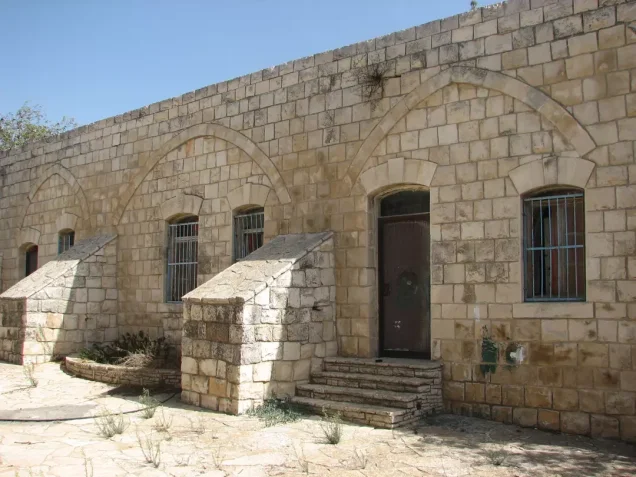
Al-Ras Al-Ahmar
About the depopulated village of Al-Ras Al-Ahmar
- District
- Safed
- Date Al-Ras Al-Ahmar was occupied
- 30 October 1948
- Population in 1948
- 719
- Military operation
- Operation Hiram
- Brigade that carried it out
- The Seventh Brigade
- Distance from the governorate centre
- 8.5 km north of Safad
- Elevation above sea level
- 825 m
- Cause of displacement
- Fear after news of the massacres perpetrated the night before at Safsaf and Jish, as Israeli occupation forces advanced on the village in Operation Hiram, according to Morris as cited by Khalidi
- Extent of destruction
- The village has been mostly destroyed, and few houses remain which are being occupied and renovated by Jewish settlers.
- Ethnic cleansing
- al-Ras al-Ahmar inhabitants were completely ethnically cleansed.
- Settlements built on the built-up area of Al-Ras Al-Ahmar after 1948
- Kerem Ben Zimra, established by Israel in 1949 on village land just east of, if not on top of, the village site
Hover a dot to read the village name, or click to open its card.
Borders of the depopulated village of Al-Ras Al-Ahmar
al-Ras al-Ahmar: A Depopulated Palestinian Village in the Safad District
Al-Ras al-Ahmar was a depopulated Palestinian village in the Safad District, located approximately 8.5 kilometers north of the city of Safad at an average elevation of about 825 meters above sea level. The village stood on a flat hilltop and was linked by unpaved roads to Safad, Taytaba, al-Rihaniyya, and neighboring villages.
- Subdistrict
- Safad
- Distance from district center
- 8.5 km north of Safad
- Average Elevation
- 825 m above sea level
- Population in 1931
- 447
- Number of Houses in 1931
- 92
- Population in 1944/1945
- 620
- Estimated Population in 1948
- About 719 – a later demographic estimate, not an official census
- Total Land Area in 1945
- 7,934 dunams
- Attack and Depopulation
- Israeli occupation forces attacked the village on 30 October 1948 during Operation Hiram; when units of the Seventh (Sheva') Brigade reached it, they found it empty of its inhabitants, according to Israeli reports quoted by Morris as cited by Khalidi. Morris implies that the villagers fled when they heard of the massacres perpetrated the night before at Safsaf and Jish, and they probably went to Lebanon.
- Final Israeli Control
- 30 October 1948, during Operation Hiram
- Military Operation
- Operation Hiram
- Military Unit
- Units of the Seventh (Sheva') Brigade, according to Khalidi
- Cause of Depopulation
- Fear after news of the massacres perpetrated the night before at Safsaf and Jish, as Israeli occupation forces advanced on the village in Operation Hiram, according to Morris as cited by Khalidi
- Settlements Documented on Village Lands
- Kerem Ben Zimra, established by Israel in 1949 on village land just east of, if not on top of, the village site
All of al-Ras al-Ahmar's inhabitants were Muslims, and the village economy depended largely on agriculture and animal husbandry. During the Nakba and the occupation of Palestine in 1948, units of the Sheva' Brigade, also known as the Seventh Brigade, captured the village on 30 October 1948 during Operation Hiram. Most of its inhabitants had already left before the troops entered, and the settlement of Kerem Ben Zimra was established on village land in 1949.
Location of al-Ras al-Ahmar
- Al-Ras al-Ahmar was located approximately 8.5 kilometers north of Safad.
- Its average elevation was about 825 meters above sea level.
- The village stood on the flat summit of al-Ras al-Ahmar, with steep slopes to the north, east, and west.
- An unpaved road connected the village with Safad and passed through Taytaba to the south.
- Another road branching from the Safad–Kafr Bir'im road linked it with Taytaba and al-Rihaniyya.
al-Ras al-Ahmar During the Ottoman Period
In 1596, al-Ras al-Ahmar was a village in the nahiya of Jira within the liwa' of Safad. According to Ottoman records cited by Walid Khalidi, its population was approximately 418.
The inhabitants paid taxes on crops and agricultural products including wheat, barley, and vineyards, as well as goats, beehives, and a press used for processing olives or grapes.
In the late nineteenth century, travelers described al-Ras al-Ahmar as a stone-built village situated on a high hill where the inhabitants maintained gardens. Contemporary estimates placed its population between 150 and 350.
The Built Environment of al-Ras al-Ahmar
Because of the steep slopes to the north, east, and west, later construction in the village expanded mainly toward the south.
All of the inhabitants were Muslims. Al-Ras al-Ahmar had an elementary school for boys that was established during the British Mandate period. Palestine Remembered states that the highest grade taught at the school was the fourth elementary grade.
A spring on the northern edge of the village supplied the inhabitants with water for domestic use.
Land Ownership in al-Ras al-Ahmar
The total land area recorded for al-Ras al-Ahmar in the 1944/1945 statistics was 7,934 dunums. The Arabic Palestine Remembered table uses the categories “Palestinian,” “Transferred to Zionists,” and “Masha'.” These terms are preserved below to reflect the wording of that source.
The Government of Palestine statistics, as reproduced by PalQuest, record 7,931 dunums as Arab-owned and 3 dunums as public land, with no Jewish-owned land recorded within the village lands.
Land Ownership in al-Ras al-Ahmar, 1944/1945, Using the Terminology of Palestine Remembered
- Palestinian7,931 dunums100%
- Transferred to Zionists0 dunums0%
- Masha' / Communal3 dunums<1%
Land Use in al-Ras al-Ahmar in 1944/1945
A total of 5,736 dunums was cultivated or classified as cultivable land, including 4,728 dunums devoted to cereals and 1,008 dunums irrigated or used for plantations.
Non-cultivable land totaled 2,137 dunums, consisting of 2,134 dunums of Arab land and 3 dunums of public land. The built-up area covered a further 61 dunums.
Land Use in al-Ras al-Ahmar According to the 1944/1945 Statistics
- Arab
- Public
- Cereals4,728 dunums
- Plantations and Irrigable Land1,008 dunums
- Built-up Area61 dunums
- Non-Cultivable Land2,137 dunums
During the 1942/1943 season, approximately 350 dunums of village land were planted with olive trees, concentrated northwest, southwest, and southeast of the village. This figure refers specifically to the 1942/1943 season and should not be treated as an additional independent category in the 1944/1945 land-use table.
Economic Life in al-Ras al-Ahmar
The village economy depended on agriculture and animal husbandry. Cereals were among the principal crops, while the inhabitants also cultivated citrus, other fruit trees, and olives.
Citrus orchards and other fruit trees were concentrated primarily on land north of the village, while extensive areas were devoted to cereal cultivation.
Population of al-Ras al-Ahmar
The 1922 census recorded 405 inhabitants in al-Ras al-Ahmar. The population increased to 447 in the 1931 census. The Government of Palestine's 1944/1945 statistics recorded 620 inhabitants, all of them Arab Muslims.
The figure of 719 inhabitants for 1948 and the estimate of 4,417 refugees for 1998 published by Palestine Remembered are later estimates and are not official Government of Palestine censuses.
Population of al-Ras al-Ahmar
- 1596418Historical figure based on Ottoman records
- Late 19th century150–350Contemporary historical estimates
- 1922405Official census under the British Mandate
- 1931447Official census under the British Mandate
- 1944/1945620Government of Palestine statistics
- 1948719Estimate published by Palestine Remembered
- 19984,417Estimated refugee population published by Palestine Remembered
Number of Houses in al-Ras al-Ahmar
The 1931 census recorded 92 houses in al-Ras al-Ahmar. The figure of 147 houses for 1948 published by Palestine Remembered is a later estimate rather than an official Government of Palestine census figure.
Number of Houses in al-Ras al-Ahmar
- 193192Official census
- 1948147Estimate published by Palestine Remembered
Education in al-Ras al-Ahmar
Al-Ras al-Ahmar had an elementary school for boys established during the British Mandate period. Palestine Remembered states that instruction reached the fourth elementary grade.
Oral accounts from former villagers refer to an earlier school that was damaged during the Great Palestinian Revolt and to a later school south of the village that also received pupils from neighboring villages. These details, however, derive from oral testimony and have not been sufficiently corroborated in the principal sources used here to present them as established historical facts.
Archaeological Remains in al-Ras al-Ahmar
Archaeological remains at al-Ras al-Ahmar indicate an ancient history of settlement. Among the documented remains were mosaic floors and wine presses with tessellated flooring.
These remains provide evidence that the site was inhabited during the Classical or Byzantine period.
Operation Hiram
Al-Ras al-Ahmar was occupied in the course of Operation Hiram, a large-scale Israeli military offensive directed against the Upper Galilee during the final days of October 1948.
The operation began on 28 October and ended on 31 October 1948. Its principal forces included units from the Sheva', Carmeli, Golani, and Oded Brigades, and al-Ras al-Ahmar was among the Palestinian villages affected by the operation.
The Occupation of al-Ras al-Ahmar and the Displacement of Its Inhabitants During the Nakba
Units of the Sheva' Brigade, also known as the Seventh Brigade, captured al-Ras al-Ahmar on 30 October 1948 during Operation Hiram.
According to Walid Khalidi, citing Israeli historian Benny Morris, the villagers probably left after receiving news of what had occurred at Safsaf and Jish the previous night. Al-Ras al-Ahmar lay immediately north of those two villages.
Israeli reports cited by Morris, as reproduced by Khalidi and PalQuest, state that units of the Seventh Brigade found al-Ras al-Ahmar empty when they reached it. This account is included because it is cited by the Palestinian source Khalidi/PalQuest and is not based on independent reliance on an Israeli source.
Khalidi considers it likely that most of the inhabitants went to Lebanon, as did many other Palestinians from the northern Galilee during the Nakba. Israeli forces subsequently continued their advance toward and across the Lebanese border.
The occupation during Operation Hiram prevented the people of al-Ras al-Ahmar from returning to their village, turning their flight into permanent displacement after the seizure of the village and its lands.
Occupation and Depopulation Chronology
- 28 October 1948
Beginning of the military operation
Israeli occupation forces launched Operation Hiram in Upper Galilee with units of the Sheva' (Seventh), Carmeli, Golani and 'Oded Brigades; PalQuest lists al-Ras al-Ahmar among the villages it affected.
- Probably 29–30 October 1948
Beginning of the exodus
Israeli historian Benny Morris, as cited by Khalidi, implies that the villagers fled when they heard of the massacres perpetrated the night before the attack on their village at Safsaf and Jish, which lie just south of it. They probably went to Lebanon, like most of the population of the northern Galilee.
- 30 October 1948
Final occupation
Israeli occupation forces attacked the village and it was captured by units of the Seventh (Sheva') Brigade, which committed a number of atrocities during the operation; they found it empty of its inhabitants, according to Israeli reports quoted by Morris as cited by Khalidi.
- By May 1949
Renaming of the village and preparation for Jewish immigrants
The empty village had been renamed Kerem Ben Zimra and was being readied to receive new Jewish immigrants.
- 1949
Settlement on village lands
Israel established the settlement of Kerem Ben Zimra on village land, just east of, if not on top of, the village site.
Settlement Established on the Lands of al-Ras al-Ahmar
In 1949, Israel established the settlement of Kerem Ben Zimra on the lands of al-Ras al-Ahmar, immediately east of the village site, if not partly on the site itself.
Walid Khalidi states that by May 1949 the emptied village had been given the new name Kerem Ben Zimra and was being prepared to receive Jewish immigrants.
- Kerem Ben Zimra: established in 1949 on the lands of al-Ras al-Ahmar, immediately east of or partly on the village site.
The Site of al-Ras al-Ahmar After the Nakba
According to Walid Khalidi's field description, several village houses remained standing. One house had a front staircase and a covered garage that appeared to have been added later, while another had two tall arched windows.
Stone rubble from demolished houses was scattered across the site, where a few fig trees and cactuses also continued to grow.
Residents of the nearby settlement cultivated some of the surrounding land and used other areas for grazing livestock.
This description is based on fieldwork conducted for Walid Khalidi's All That Remains and should not necessarily be treated as a field survey updated to the present day.
Sources
- PalQuestPalQuest – Interactive Encyclopedia of the Palestine Question: al-Ras al-Ahmar
- PalQuestPalQuest – Interactive Encyclopedia of the Palestine Question: Operation Hiram
- Institute for Palestine StudiesInstitute for Palestine Studies: Walid Khalidi, All That Remains
- Palestine RememberedPalestine Remembered: al-Ras al-Ahmar – Safad District
```
Photo gallery


Photos from the village's people
Photos sent in by visitors and published after review.
Add a photo of this village
Log in to add photos of this village.
Other villages from Safed

More from the archive



 Download Our Palestine App
The whole archive in the palm of your hand: depopulated villages, the Nakba, the massacres and Al-Aqsa — free, with no ads to erase the story.
Download Our Palestine App
The whole archive in the palm of your hand: depopulated villages, the Nakba, the massacres and Al-Aqsa — free, with no ads to erase the story.



Comments
No comments yet — be the first to write one.
Add your comment
Name and email are optional. Comments appear after review.