
The depopulated village of Yarda / District of Safed

About the depopulated village of Yarda
- District
- Safed
- Date Yarda was occupied
- 01 April 1948
- Population in 1948
- 20
- Military operation
- Operation Yiftach
- Brigade that carried it out
- Palmach
- Distance from the governorate centre
- 10.5 (km) North East of Safad
- Elevation above sea level
- 225
- Cause of displacement
- Military assault by Zionist troops
- Extent of destruction
- The village has been mostly destroyed with the exception of deserted houses
- Ethnic cleansing
- The village has been completely ethnically cleansed between 1949 and 1956
- Settlements built on the land of Yarda before 1948
- Ayelet Hashachar
- Settlements built on the built-up area of Yarda after 1948
- Mishmar HaYarden
Hover a dot to read the village name, or click to open its card.
Borders of the depopulated village of Yarda
Yarda – Depopulated Palestinian Village in Safad Subdistrict
Yarda was a small Palestinian village in the Safad subdistrict of Galilee. It lay approximately 10.5 kilometers northeast of Safad at an average elevation of about 225 meters above sea level. The village stood on volcanic terrain sloping northward toward the al-Hula Plain.
Yarda was among the smallest communities in the Safad subdistrict. Its population numbered 13 Muslims in the official 1931 census and 20 inhabitants in the official 1944/45 statistics. The area was notably rich in water resources, enabling villagers to cultivate rice, clover, maize, and vegetables.
The occupation and depopulation of Yarda cannot be reduced to a single securely established date. Walid Khalidi states that the village may first have been occupied during Operation Yiftach in April–May 1948. It subsequently lay on the edge of the Demilitarized Zone established after the Syrian-Israeli Armistice Agreement of 1949, leaving uncertainty over whether inhabitants remained or returned before a later removal.
Key Facts about Yarda
| Field | Information |
|---|---|
| Name | Yarda |
| Subdistrict | Safad |
| Status | Depopulated Palestinian village |
| Distance from Safad | Approximately 10.5 km northeast |
| Average elevation | Approximately 225 m above sea level |
| Population in 1931 | 13 – official census |
| Population in 1944/45 | 20 – official statistics |
| Houses in 1931 | 3 – official census |
| Land area | Source discrepancy: 1,368 dunums in PalQuest versus 1,367 Arab dunums in the reproduced official Village Statistics; see land section |
| Probable military operation | Operation Yiftach |
| Unit that specifically occupied Yarda | Not independently documented; the Palmach's First Battalion spearheaded Operation Yiftach as a whole |
| First occupation | Uncertain; Khalidi suggests April–May 1948 |
| Final depopulation | Not precisely established; a later removal between 1949 and 1956 is possible if inhabitants remained or returned |
| Settlements associated with village land | Ayyelet ha-Shahar and the new Mishmar ha-Yarden |
Location of Yarda
Yarda lay in the eastern part of the Safad subdistrict on terrain descending toward the al-Hula Plain and not far west of the Jordan River and the former Palestine-Syria frontier. Its landscape was characterized by volcanic rock and relatively abundant water resources.
Maps and Palestinian sources place Yarda among the eastern Galilee and Hula-area villages, near al-Wayziyya, Kirad al-Baqqara, Kirad al-Ghannama, and Mansurat al-Khayt, within the broader vicinity of Jisr Banat Ya'qub.
The Name Yarda
The village appears in Arabic sources as both Yarda and Yārda. The principal sources used here do not establish a single definitive etymology, and no proposed linguistic derivation is therefore presented as a proven fact.
Yarda before the Nakba
The village stood on volcanic rock in an area sloping northward toward the al-Hula Plain. All of its inhabitants were Muslims.
Despite the very small size of the population, the surrounding area had relatively abundant water. These resources allowed the cultivation of water-intensive and irrigated crops, particularly rice, as well as clover, maize, and vegetables.
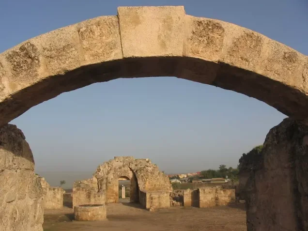
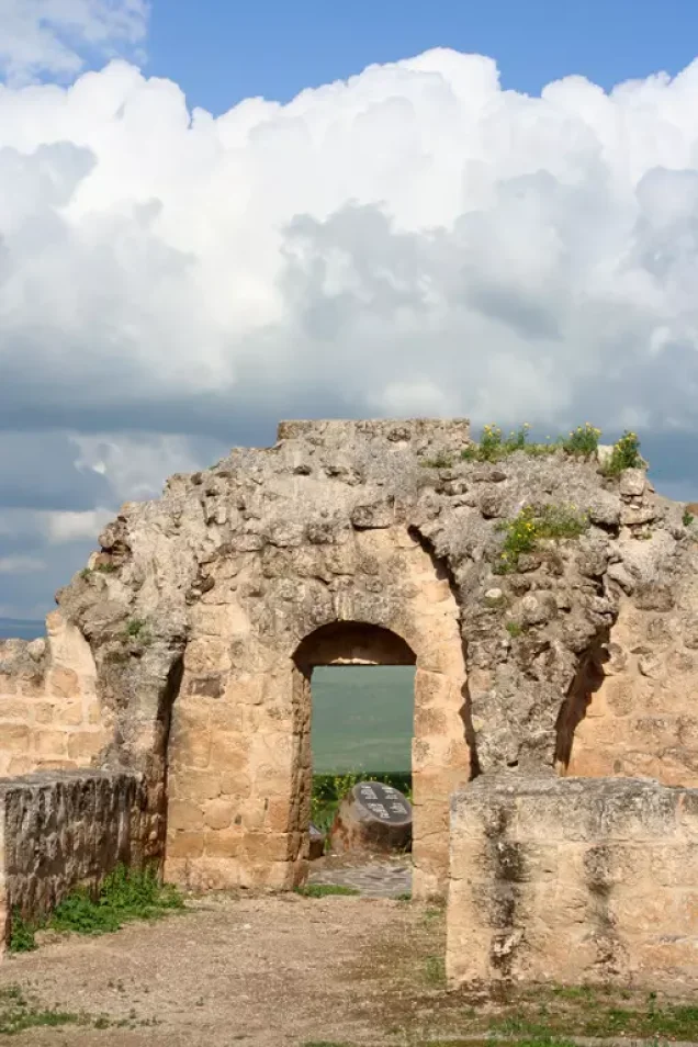
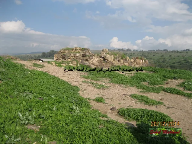
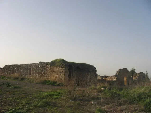
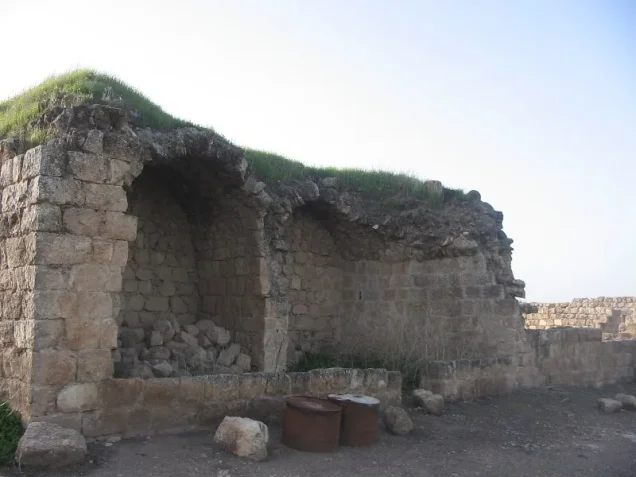
A khan, or caravanserai, also stood in the village. Portions of its walls remained visible after the destruction of Yarda and became one of the most prominent surviving features recorded in Walid Khalidi's field documentation.
Population of Yarda
- 193113Official census; all Muslims
- 1944/4520Official British Mandate statistics
- 194823Later estimate reported by Palestine Remembered; not an official census
- 1998143 refugeesLater estimate reported by Palestine Remembered
The principal sources reviewed do not provide a separately verified 1922 population figure for Yarda, so no unverified number has been added.
Number of Houses
- 19313Official 1931 census figure
- 19485Later estimate reported by Palestine Remembered
The estimate of five houses in 1948 should not be described as an official census count.
Yarda's Land and the Statistical Discrepancy
A small but significant discrepancy exists in the recorded land area of Yarda. PalQuest gives a total of 1,368 dunums, all listed in the Arab category, and Palestine Remembered likewise presents 1,368 dunums as Palestinian land.
However, Sami Hadawi's reproduction of the official 1945 Village Statistics lists the combined statistical entry “Aiyelet hash Shahar and Yarda” with 1,367 dunums in the Arab ownership category. Moreover, the land-use figures associated with Yarda—1,359 dunums of cereals and 8 dunums of uncultivable land—sum to 1,367 dunums.
| Source | Figure | Note |
|---|---|---|
| PalQuest | 1,368 dunums | Shown entirely in the Arab land category |
| Palestine Remembered | 1,368 dunums | Palestinian 1,368; Transferred to Zionists 0; Communal/Public 0; its displayed total contains an obvious error |
| Village Statistics / Hadawi | 1,367 Arab dunums | Within the combined statistical unit with Ayyelet ha-Shahar; consistent with Yarda's published land-use total |
The discrepancy should not be silently erased. For analysis of land use, this article uses 1,367 dunums because that figure is internally consistent with the official land-use breakdown, while noting that PalQuest records 1,368 dunums.
Land Use in 1944/45
- Cereals1,359 dunums99%
- Uncultivable land8 dunums<1%
This official classification should be distinguished from the crop list recorded by Khalidi. His references to rice, clover, maize, and vegetables describe agricultural activity but do not provide separate official acreage for each crop.
Economic Life in Yarda
Yarda's economy was based primarily on agriculture. Abundant water was a defining resource and made possible the cultivation of rice, a water-intensive crop, as well as clover, maize, and vegetables.
The official land-use data indicate that the great majority of the recorded land was devoted to cereals, totaling 1,359 dunums.
The principal sources reviewed do not provide sufficient documentation to describe trade, crafts, or livestock raising as major separate economic sectors, and such details have therefore not been added without evidence.
Water Resources
Walid Khalidi describes Yarda as well endowed with water resources. This abundance made possible a relatively diverse agricultural pattern despite the village's very small population, including rice, clover, maize, and vegetable cultivation.
The village entry does not provide a comprehensive list of named springs or wells, so specific water-source names have not been added without independent documentation.
Archaeology and Khirbat Waqqas
Khirbat Waqqas, also called Khirbat al-Qadah, lay west-northwest of Yarda. Walid Khalidi records that the site was identified with the ancient city of Hazor.
Palestinian sources also record remains of buildings and walls, cut stones, cisterns, and a press in the archaeological area. Because the identification and boundaries of archaeological sites in this region are complex, Yarda itself should be distinguished from Khirbat Waqqas and neighboring ancient remains rather than treating them all as a single undifferentiated site.
Education and Institutions
The principal sources reviewed do not provide documented evidence of an independent school in Yarda, its founding date, or student enrollment. Given the village's very small population, no local educational institution should be assumed without an explicit source.
Operation Yiftach
Operation Yiftach was carried out between 15 April and 25 May 1948 as part of the military campaign for control of eastern Galilee. The operation was planned under Palmach commander Yigal Allon, and the Palmach's First Battalion served as its spearhead at the operational level.
PalQuest lists Yarda among the villages affected by Operation Yiftach. This does not, however, independently establish that the First Battalion was the unit that specifically entered Yarda. The village entry itself does not identify the attacking unit at village level.
Occupation and Depopulation of Yarda
The precise date of Yarda's first occupation is not known. Walid Khalidi cautiously states that the village may first have been occupied during Operation Yiftach in April–May 1948.
For this reason, the date 1 April 1948 displayed in Palestine Remembered's summary table is not treated here as established. It predates the formal beginning of Operation Yiftach on 15 April, while the detailed narrative on the same page reproduces Khalidi's qualified April–May chronology.
Following the Syrian-Israeli Armistice Agreement of July 1949, Yarda lay on the periphery of the Demilitarized Zone. Khalidi writes that if Yarda remained inhabited through the end of Operation Yiftach, or if inhabitants later returned, they may have shared the fate of other Palestinian communities within the Demilitarized Zone.
In that broader context, Khalidi cites an account that residents of DMZ villages were removed by Israeli authorities between 1949 and 1956 through direct and indirect pressure. This does not establish a village-specific final expulsion date for Yarda, and the 1949–1956 period should therefore remain a qualified possibility rather than a precise date of depopulation.
Palestine Remembered classifies Yarda's depopulation as complete ethnic cleansing and gives direct military assault as the cause of exodus. In more narrowly descriptive terms supported by the principal source, Yarda's depopulation was connected first to the military campaign in eastern Galilee and subsequently to the conditions created in and around the Demilitarized Zone, while the precise date of final removal remains uncertain.
Occupation Chronology
- 15 April 1948
Beginning of Operation Yiftach
The Palmach began the wider operation to gain control of eastern Galilee.
- April–May 1948
Possible first occupation of Yarda
Walid Khalidi states that Yarda may first have been occupied during Operation Yiftach; no exact date is given.
- 25 May 1948
End of Operation Yiftach
The village entry does not establish with certainty that Yarda was already permanently empty of its inhabitants at this point.
- July 1949
Armistice and Demilitarized Zone
Yarda subsequently lay on the periphery of the Syrian-Israeli Demilitarized Zone.
- 1949–1956
Possible later removal
If residents remained or returned, Khalidi suggests that they may have shared the fate of other DMZ villagers who were removed under direct and indirect pressure. No village-specific date is established.
- Precise date not documented
Destruction
Most structures were destroyed, although parts of house walls and the village khan survived.
Israeli Settlements on Yarda's Lands
An important distinction must be made between an existing Zionist settlement that took over Yarda land after 1948 and a new settlement subsequently established directly on village land.
| Settlement | Date | Relationship to Yarda |
|---|---|---|
| Ayyelet ha-Shahar | Established before 1948 | Khalidi states that it took over land belonging to Yarda in 1948; it was not founded in 1948 |
| Mishmar ha-Yarden | 1949 | Established on Yarda's land approximately one kilometer east of the village site |
The Mishmar ha-Yarden established in 1949 on Yarda's lands should not be confused with an older settlement bearing the same name that had been founded in 1890 near Jisr Banat Ya'qub.
Yarda Today
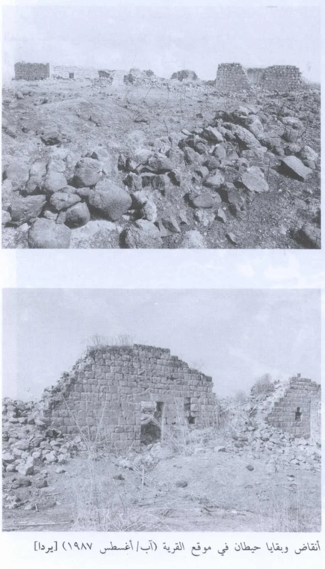
In Walid Khalidi's field documentation, truncated sections of some house walls remained standing, together with walls of the village khan. Stones from destroyed houses were scattered across the site, and part of the land was being used as pasture.
PalQuest dates Khalidi's field photographs of Yarda to August 1987. His description therefore documents the site in that period rather than providing direct field verification of its condition in 2026.
Palestine Remembered also contains later community documentation of the khan and village site, including images captioned as dating from 2005 and 2014 and more recent contributions labeled 2022 and 2023. These materials indicate that elements of the khan and village remains continued to be documented at later dates, but they do not constitute a comprehensive independent survey of all village lands or present-day conditions.
Sources
- PalQuest – Interactive Encyclopedia of the Palestine Question: Yarda
- PalQuest – Operation Yiftach
- Palestine Remembered – Yarda, Safad District
- Walid Khalidi – All That Remains: Yarda
- Institute for Palestine Studies – All That Remains, Walid Khalidi
- Village Statistics of 1945 – Sami Hadawi reproduction of Government of Palestine statistics
Photo gallery












Photos from the village's people
Photos sent in by visitors and published after review.
Add a photo of this village
Log in to add photos of this village.
Other villages from Safed


More from the archive



 Download Our Palestine App
The whole archive in the palm of your hand: depopulated villages, the Nakba, the massacres and Al-Aqsa — free, with no ads to erase the story.
Download Our Palestine App
The whole archive in the palm of your hand: depopulated villages, the Nakba, the massacres and Al-Aqsa — free, with no ads to erase the story.



Comments
No comments yet — be the first to write one.
Add your comment
Name and email are optional. Comments appear after review.