
The depopulated village of Taytaba / District of Safed
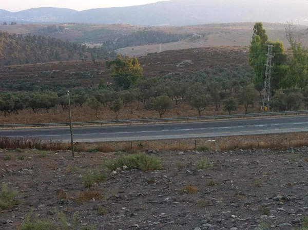
Taytaba
About the depopulated village of Taytaba
- District
- Safed
- Date Taytaba was occupied
- 01 May 1948
- Population in 1948
- 620
- Military operation
- Operation Hiram
- Elevation above sea level
- 800 m
- Cause of displacement
- Military assault by Zionist troops
- Extent of destruction
- The village has been completely destroyed, and only the rubble of destroyed houses left behind.
- Ethnic cleansing
- The village has been mostly ethnically cleansed at the end Operation Yiftach (25th of May 1948)
- Settlements built on the built-up area of Taytaba after 1948
- A part of Dalton
Hover a dot to read the village name, or click to open its card.
Borders of the depopulated village of Taytaba
Taytaba – Depopulated Palestinian Village of the Safad District
Taytaba was a depopulated Palestinian village in the Safad District. It stood on rocky ground at the crest of a volcanic hill in Upper Galilee, approximately 5 kilometers north of Safad, at an average elevation of about 800 meters above sea level.
The exact date of Taytaba's occupation and depopulation is uncertain. Walid Khalidi considers it most likely that the village was taken during the later stages of Operation Yiftach in May 1948 and that its inhabitants left or were expelled sometime between the fall of Safad on 11 May and the end of the operation on 25 May. A large part of the population had apparently already begun leaving in early May after the violence at nearby 'Ayn al-Zaytun.
Location and Geography
Taytaba stood on a rocky volcanic hilltop overlooking Wadi Taytaba, a tributary of Wadi Waqqas, to the southeast.
The village was approximately 5 kilometers north of Safad and had an average elevation of about 800 meters above sea level.
It occupied a watershed between drainage systems flowing toward the al-Hula plain and those flowing toward Lake Tiberias. To the east, upper watercourses fed Wadi Waqqas and the al-Hula basin, while to the west upper channels led toward Wadi al-Laymun and Lake Tiberias.
A secondary road connected Taytaba with Safad and continued north toward al-Ras al-Ahmar, al-Rihaniyya, and 'Alma. Other tracks linked the village with Dallata, Qaddita, 'Ammuqa, and surrounding Upper Galilee villages.
Its lands bordered those of Dallata, al-Ras al-Ahmar, al-Jish, al-Rihaniyya, Qaddita, 'Ammuqa, and al-Safsaf. 'Ayn al-Zaytun lay to its south.
Name and Historical Background
The name Taytaba appears in local and historical documentation over a long period. The available evidence does not securely establish a single linguistic derivation for the name.
In 1596, Taytaba belonged to the nahiya of Jira in the liwa' of Safad. Historical tax-register research gives an estimated population of approximately 434. The villagers paid taxes on goats and beehives together with a fixed payment.
In the late nineteenth century, Taytaba was described as a stone-built village with approximately 200 inhabitants. Its residents cultivated gardens west of the village site.
A late Ottoman population list recorded approximately 455 inhabitants, all Muslims.
Built Environment
In the modern period, Taytaba's houses were constructed of stone and adobe. The village developed around a branching road network, with some houses extending toward agricultural land to the east and toward the track leading southwest to Qaddita.
The official 1944/45 statistics classified approximately 61 dunams as built-up land.
Population and Houses
The inhabitants of Taytaba were Muslims.
- 1596About 434Historical estimate derived from Ottoman records rather than a modern census
- 1922269Official Census of Palestine; all inhabitants were Muslims
- 1931364Official census; all inhabitants were Muslims
- 1945530Official statistics; all inhabitants were Palestinian Arab Muslims
- 1948About 615Later Palestine Remembered estimate, not an official British census
- 1998About 3,776 refugees and descendantsLater demographic estimate
The official 1931 census recorded 60 houses. The figure of approximately 101 houses for 1948 is a later estimate and not an official census count.
Several Palestinian secondary sources contain numerical errors. The Palestinian Encyclopedia and Palestine Remembered give 299 inhabitants for 1922, while the official 1922 census records 269. The Palestinian Encyclopedia also gives 365 inhabitants and only 20 houses for 1931, whereas the official figures used by PalQuest are 364 inhabitants in 60 houses.
Mosque and Education
Taytaba had a mosque in the southern part of the village and a boys' elementary school established during the British Mandate. Both are explicitly documented by Walid Khalidi.
Palestine Remembered states that the school extended through the fourth grade, while Khalidi's principal entry documents the boys' elementary school without providing a full grade-by-grade enrollment history.
Supporting Palestinian community documentation names two Muslim shrines, Maqam al-Shaykh Ayyub and Maqam al-Shaykh Mansur, and also reports a class for girls. Since these details are not all independently established in Khalidi's principal entry, they are treated as supporting community documentation rather than official educational statistics.
A generic church entry appearing in one Palestine Remembered table is not supported by the principal historical account, which describes the population as entirely Muslim. A church is therefore not included as an established village institution.
Water and Drainage
Taytaba stood along the watershed separating the al-Hula drainage basin from the watercourses flowing toward Lake Tiberias.
To the east, upper streams fed Wadi Waqqas and the al-Hula basin. To the west, upper channels fed Wadi al-Laymun toward Lake Tiberias.
The principal sources reviewed do not securely identify a particular named spring or well as Taytaba's main domestic water source. No unverified water-source names have therefore been added.
Economic Life and Agriculture
Agriculture was the principal source of livelihood. Villagers cultivated the arable land surrounding the volcanic hill and maintained gardens west of the village.
The principal crops included cereals, fruit trees, and olives. The Palestinian Encyclopedia records olive cultivation on the southern slopes and fruit trees to the north of the village.
In 1944/45, 5,178 dunams were devoted to cereals when Arab and Public land are combined, while 585 dunams were classified as plantations or irrigable land.
Palestinian sources also give a crop-specific figure of approximately 350 dunams planted with olives. This falls within the broader agricultural categories and should not be added again to the total land-use calculation.
Land Ownership, 1944/45
The total land area of Taytaba was 8,453 dunams. Under the official Government of Palestine classification, ownership was distributed as follows:
- Arab8,441 dunums100%
- Jewish0 dunums0%
- Public12 dunums<1%
Palestine Remembered presents the same totals using its simplified terminology: 8,441 dunams “Palestinian,” 0 dunams “Transferred to Zionists,” and 12 dunams “Communal/Public.” The phrase “Transferred to Zionists” should be retained when reproducing that source's classification.
Land Use, 1944/45
- Arab
- Public
- Cereals5,178 dunums
- Plantations and irrigable land585 dunums
- Total cultivable/cultivated land5,763 dunums
- Non-cultivable land2,629 dunums
- Built-up land61 dunums
- Total non-cultivable and built-up2,690 dunums
The official table balances exactly: 5,763 dunams of cultivated or cultivable land plus 2,690 dunams of built-up and non-cultivable land equal the village's total area of 8,453 dunams.
Palestine Remembered's simplified table places the full cereal total of 5,178 dunams, the full non-cultivable total of 2,629 dunams, and the 61 built-up dunams in the Palestinian column. The official table shows that small portions of each category were classified as Public land, so Public land has been kept separate above.
Archaeological Remains
East of Taytaba stood Tall al-Tasarif, which contained remains of an ancient tomb. North of the village was a field of ancient stone burials or dolmens associated with prehistoric periods.
These remains indicate a long history of human activity around Taytaba, but the principal sources do not support assigning every archaeological feature to a single period.
Some Palestinian local sources identify the ancient burial remains as Roman. Because Khalidi's account does not establish that more precise dating for all of the remains, this article retains the more cautious description of an ancient tomb and prehistoric dolmens.
Military Incidents in February 1948
Several military incidents preceded Taytaba's final occupation.
On 12 February 1948, a British patrol approached the village, where armed Arab volunteers were reportedly present. Fighting followed, British reinforcements were sent, and the patrol eventually withdrew. The account reproduced by Khalidi records no casualties.
On 15 February, shortly after the Haganah attack on nearby Sa'sa', a Haganah raiding party attacked Taytaba. The source used by Khalidi provides no further reliable details about the consequences of this raid.
These February incidents should be distinguished from the village's final occupation months later.
Operation Yiftach
Operation Yiftach ran from 15 April to 25 May 1948 under the framework of Plan Dalet, with the objective of gaining control of eastern Galilee before the end of the British Mandate.
The Palmach was the principal force in the campaign, and its First Battalion spearheaded the operation at the overall operational level. The campaign resulted in the depopulation of Safad and numerous Palestinian villages across eastern Galilee.
Although Taytaba does not appear in the shortened affected-villages list displayed on PalQuest's Operation Yiftach page, Khalidi's village-specific account clearly considers its capture during the later stages of Yiftach the most likely scenario.
Early Displacement
The departure of Taytaba's inhabitants apparently began before the site's final military occupation.
Palestinian historian Nafez Nazzal states that “almost all” the villagers fled in early May 1948 because of the bloody events at nearby 'Ayn al-Zaytun.
This makes it necessary to distinguish the beginning of civilian displacement from the later physical capture of the village site.
Occupation of Taytaba
Walid Khalidi explicitly states that the exact date of Taytaba's occupation is difficult to determine.
He presents two possibilities. The first, and more likely, is that Taytaba was overrun together with 'Ammuqa and Qaddita during the later stages of Operation Yiftach in May 1948. The second is that the village may have survived until Operation Hiram in late October.
Khalidi considers the Yiftach scenario more likely because the front line at the beginning of Operation Hiram ran just west of Taytaba, implying that the village area had already fallen east of Israeli lines.
The most cautious dating is therefore that Taytaba came under Israeli military control and that the remaining villagers left or were expelled sometime between the fall of Safad on 11 May and the end of Operation Yiftach on 25 May 1948.
The “1 May 1948 / Operation Hiram” combination displayed in the summary fields of Palestine Remembered is not used here. It conflicts with the historical narrative reproduced on that same page and with Khalidi's conclusion that Yiftach in May is the more likely context.
Military Unit
The early raid on 15 February was carried out by a Haganah raiding party.
If Khalidi's preferred Yiftach scenario is followed for the final occupation, the principal operational force was the Palmach.
The Palmach's First Battalion spearheaded Operation Yiftach as a whole, but the Taytaba village entry does not identify a specific battalion as the force that physically occupied the village. The final capture should therefore not be assigned conclusively to the First Battalion without village-specific evidence.
Occupation Chronology
- 12 February 1948
Clash with a British patrol
An armed clash occurred near Taytaba between Arab fighters and a British patrol. The account reproduced by Khalidi records no casualties.
- 15 February 1948
Haganah raid
A Haganah raiding party attacked Taytaba; the available report gives no detailed outcome.
- 15 April 1948
Beginning of Operation Yiftach
Palmach forces launched the campaign to seize eastern Galilee under Plan Dalet.
- Early May 1948
Departure of most villagers
According to Nafez Nazzal, almost all Taytaba residents fled after the violence at nearby 'Ayn al-Zaytun.
- 10–11 May 1948
Fall of Safad
The fall and depopulation of the district capital accelerated the collapse of surrounding Palestinian communities.
- 11–25 May 1948
Most likely period of final occupation
Khalidi considers it most likely that Taytaba was overrun during the later stages of Operation Yiftach and that remaining inhabitants left or were expelled during this period.
- 25 May 1948
End of Operation Yiftach
Official end of the campaign.
- Late October 1948
Alternative Hiram hypothesis
Khalidi mentions this as a possible alternative but considers it less likely than occupation during Yiftach.
- Exact date not documented
Destruction of the village
The houses were subsequently razed, but the principal sources do not provide a precise demolition date.
Israeli Settlements on Village Lands
According to Walid Khalidi and PalQuest, no Israeli settlement was established on Taytaba's village lands.
Dalton, an agricultural settlement established in 1950, lies nearby to the east of the former village site but is not identified by Khalidi as being on Taytaba's lands.
Taytaba Today
According to the field description published in Walid Khalidi's All That Remains, stone rubble from the destroyed village houses was scattered across the site.
A few olive trees still stood among wild grass and thorny vegetation. Parts of the surrounding land had become wooded, while other areas were used for agriculture and livestock grazing.
This description should not be treated as a field verification of conditions in 2026. Fieldwork for All That Remains was conducted between 1987 and 1990, so the description records the site's condition during that survey period.
Sources
- PalQuest – Interactive Encyclopedia of the Palestine Question: Taytaba
- PalQuest – Operation Yiftach
- Palestine Remembered – Taytaba, Safad District
- Palestinian Encyclopedia – Taytaba
- Palestinian Villages Encyclopedia – Taytaba; supporting Palestinian community documentation
- Government of Palestine – Census of Palestine 1922, Safad Sub-District
- Census of Palestine 1931 – Safad Sub-District
- Institute for Palestine Studies – Walid Khalidi, All That Remains
- PalQuest – All That Remains: Methodology
Photo gallery


Photos from the village's people
Photos sent in by visitors and published after review.
Add a photo of this village
Log in to add photos of this village.
Other villages from Safed




More from the archive


 Download Our Palestine App
The whole archive in the palm of your hand: depopulated villages, the Nakba, the massacres and Al-Aqsa — free, with no ads to erase the story.
Download Our Palestine App
The whole archive in the palm of your hand: depopulated villages, the Nakba, the massacres and Al-Aqsa — free, with no ads to erase the story.



Comments
No comments yet — be the first to write one.
Add your comment
Name and email are optional. Comments appear after review.