
The depopulated village of Kafr Bir'im / District of Safed
Kafr Bir'im
About the depopulated village of Kafr Bir'im
- District
- Safed
- Population in 1948
- 824
- Military operation
- Operation Hiram
- Brigade that carried it out
- Not identified in the sources; Operation Hiram was carried out by the Seventh (Sheva'), Carmeli, Golani and Oded Brigades
- Distance from the governorate centre
- 11.5 km northwest of Safad
- Elevation above sea level
- 750 m
- Cause of displacement
- Expulsion by Israeli occupation forces, 'temporarily' and 'for security reasons', like the inhabitants of other border villages, who were then prevented from returning to their village despite a 1952 Israeli Supreme Court ruling
- Extent of destruction
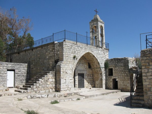
- Complete destruction of the village in 1953, Only the church and its bell tower left standing (it needs renovations, any volunteers!)
- Ethnic cleansing
- Kafr Bir'im inhabitants were completely ethnically cleansed.
- Settlements built on the built-up area of Kafr Bir'im after 1948
- Bar'am, founded in 1949 by members of the Palmach northeast of the village site, a little farther away from it; and Dovev, established in 1963 on village land northwest of the site
Hover a dot to read the village name, or click to open its card.
Borders of the depopulated village of Kafr Bir'im
Kafr Bir'im: A Depopulated Palestinian Village in the Safad District
Kafr Bir'im was a Palestinian village in the Safad District, located approximately 11.5 km northwest of Safad in Upper Galilee, at an average elevation of about 750 metres above sea level. Its population was overwhelmingly Christian, and agriculture—particularly olives, fruit trees, and cereals—formed the basis of village life. Kafr Bir'im finally came under Israeli occupation in early November 1948, in the immediate aftermath of Operation Hiram. Its inhabitants were subsequently removed on what was presented as a temporary measure for “security reasons.” Although the Israeli Supreme Court ruled in 1952 that there was no reason to prevent their return, the Israeli army destroyed most of the village in 1953.
- Subdistrict
- Safad
- Distance from district center
- 11.5 km northwest of Safad
- Average Elevation
- 750 m above sea level
- Population in 1931
- 554
- Number of Houses in 1931
- 132
- Population in 1944/1945
- 710 – 700 Christians and 10 Muslims
- Estimated Population in 1948
- About 824 – a later demographic estimate, not an official census
- Total Land Area in 1945
- 12,250 dunams
- Attack and Depopulation
- The village surrendered in early November 1948, when Galilee fell to Israeli occupation forces during Operation Hiram; its inhabitants, like those of other border villages, were then expelled 'temporarily' for 'security reasons': some were driven across the border, while those found hiding in nearby caves were taken to the village of Jish. Although the Israeli Supreme Court ruled in July 1952 that there was no reason to prevent their return, the Israeli army levelled the village in 1953.
- Final Israeli Control
- Early November 1948, when the village surrendered as Galilee fell during Operation Hiram (28–31 October 1948); the available sources do not give the day of its surrender. A United Press report of its fall on 18 May 1948 is not confirmed by the village's own entry
- Military Operation
- Operation Hiram
- Military Unit
- The available sources do not identify the unit that occupied the village; Operation Hiram was carried out by units from four brigades: the Seventh (Sheva') Brigade, the Carmeli Brigade, the Golani Brigade and the Oded Brigade.
- Cause of Depopulation
- Expulsion by Israeli occupation forces, 'temporarily' and 'for security reasons', like the inhabitants of other border villages, who were then prevented from returning to their village despite a 1952 Israeli Supreme Court ruling
- Settlements Documented on Village Lands
- Bar'am, founded in 1949 by members of the Palmach northeast of the village site, a little farther away from it; and Dovev, established in 1963 on village land northwest of the site
Location of Kafr Bir'im
Kafr Bir'im stood on a rocky hill that rose only slightly above the surrounding terrain and faced north and west.
The village was approximately 11.5 km northwest of Safad and had an average elevation of about 750 metres above sea level.
A secondary road linked it with villages to the east and west and connected with both the coastal highway and the road to Safad.
Its lands bordered those of Fara, Jish, Sa'sa', al-Ras al-Ahmar, and the Lebanese frontier.
Part of the village lands was forested, while gardens, olive trees, and vineyards surrounded the residential area.
The Name Kafr Bir'im
Walid Khalidi suggests that the name Kafr Bir'im may be a corruption of the name of an ancient Canaanite settlement rendered as Periya'm or a similar form.
Palestine Remembered additionally associates the old name with the meaning “abundant in fruit,” but Khalidi's principal entry does not establish this as a certain linguistic etymology.
The safest formulation is therefore that Kafr Bir'im may preserve the name of an earlier Canaanite locality without treating a specific translation of the ancient name as conclusively established.
Architecture of Kafr Bir'im
In the late nineteenth century, Kafr Bir'im was described as a stone-built village surrounded by gardens, olive trees, and vineyards.
The houses stood very close together and were principally built of stone.
The built-up area amounted to approximately 96 dunums in the 1944/45 statistics.
The village church was one of its most prominent buildings and became the principal intact structure to survive the later destruction of Kafr Bir'im.
Religion in Kafr Bir'im
The overwhelming majority of Kafr Bir'im's inhabitants were Christian.
In the 1944/45 statistics, the village had 710 inhabitants: 700 Christians and 10 Muslims.
Kafr Bir'im may therefore accurately be described as predominantly Christian, but it was not exclusively Christian immediately before the Nakba.
Education in Kafr Bir'im
Palestine Remembered preserves photographic documentation of an elementary school in Kafr Bir'im, including a photograph captioned as showing pupils and teachers in 1939.
The principal approved sources used here do not provide a verified founding date or enrollment figure for the school.
The existence of the elementary school is therefore recorded without adding unsupported dates or statistics.
Economic Life in Kafr Bir'im
Agriculture irrigated by the village's abundant springs was the principal source of livelihood.
The villagers were especially active in olive and fruit cultivation and also grew cereals. Vineyards and other orchards surrounded the village.
In 1944/45, 3,718 dunums were devoted to cereals and 1,101 dunums were irrigated or used for plantations.
Palestine Remembered separately records 143 dunums of olive groves. This is treated as a detail within the agricultural land rather than added again to the cultivable-land total.
Some local accounts contain additional details concerning grain milling, olive presses, tobacco processing, and lime production. These specific industrial claims are not documented in the principal Khalidi/PalQuest village entry and are therefore not presented here as established statistical facts.
Land Ownership in Kafr Bir'im
The total registered land area of Kafr Bir'im was 12,250 dunums in the 1944/45 statistics.
Land ownership in Kafr Bir'im, 1944/45, using the terminology of Palestine Remembered
- Palestinian12,244 dunums100%
- Transferred to Zionists0 dunums0%
- Communal6 dunums<1%
No land was recorded in the category “Transferred to Zionists” in the 1944/45 ownership statistics. Almost all registered land was Palestinian, with only six dunums classified as public/communal.
Land Use in Kafr Bir'im, 1944/45
Land use in Kafr Bir'im, separating ownership categories according to PalQuest's detailed statistics
- Palestinian
- Communal/Public
- Plantations and irrigable land1,101 dunums
- Cereals3,718 dunums
- Built-up area96 dunums
- Non-cultivable land7,335 dunums
A total of 4,819 dunums, approximately 39 percent of the village lands, was cultivated or cultivable.
Built-up and non-cultivable land together amounted to 7,431 dunums, approximately 61 percent of the total.
Palestine Remembered presents all 7,335 dunums of non-arable land in its Palestinian column. PalQuest's detailed statistics show that 7,329 dunums were Arab land and six dunums were public land. The communal/public category is therefore separated above.
Population of Kafr Bir'im
Population of Kafr Bir'im in selected years
- Late nineteenth centuryApproximately 300–500Historical estimate from the Survey of Western Palestine
- 1922469Official British Mandate census
- 1931554Official British Mandate census
- 1944/45710Official statistics: 700 Christians and 10 Muslims
- 1948824Later estimate published by Palestine Remembered
- Estimated refugees in 19985,058Later estimate published by Palestine Remembered
Number of Houses in Kafr Bir'im
Number of houses in Kafr Bir'im
- 1931132Official British Mandate census figure
- 1948196Later estimate published by Palestine Remembered
Archaeological Remains in Kafr Bir'im
Kafr Bir'im was an important archaeological site reflecting a long history of settlement.
The documented remains included ancient olive presses, tombs, water cisterns, and a synagogue.
The ancient synagogue should not be confused with the religious composition of the village immediately before the Nakba, when the overwhelming majority of Kafr Bir'im's inhabitants were Christian.
An Earlier Report of Kafr Bir'im's Capture in 1948
An earlier report complicates the chronology of Kafr Bir'im's final occupation.
In PalQuest's entry for neighboring Saliha, Khalidi cites United Press and Arab military sources in Amman as reporting that Saliha and Kafr Bir'im fell to Israeli forces on 18 May 1948.
Khalidi indicates in the Saliha discussion that this occupation may have been temporary. His dedicated Kafr Bir'im entry instead places the village's final surrender in early November 1948.
The 18 May report is therefore preserved as evidence of a possible earlier temporary occupation rather than treated as the final depopulation date.
Operation Hiram and Kafr Bir'im
Israeli occupation forces launched Operation Hiram in Upper Galilee from 28 to 31 October 1948 following the second truce.
At the broader operational level, the Sheva' (Seventh), Carmeli, Golani, and 'Oded brigades took part in the offensive; PalQuest's operation metadata also lists Giv'ati among units associated with Operation Hiram.
Within a few days, Israeli forces occupied most of Upper Galilee. Some Palestinian villages were emptied immediately, while inhabitants of other border villages were expelled in the following days and weeks under the stated objective of clearing the frontier.
PalQuest lists Kafr Bir'im among the villages affected by Operation Hiram but does not identify a specific brigade as the village-level occupying unit.
Occupation and Displacement of Kafr Bir'im
Kafr Bir'im surrendered in early November 1948, immediately after Operation Hiram and the Israeli occupation of Upper Galilee.
Palestine Remembered lists 4 November 1948 as the specific occupation date, while Khalidi's principal entry states only “early November.”
Since PalQuest formally dates Operation Hiram to 28–31 October, it is more precise to describe Kafr Bir'im's final surrender as occurring in the immediate aftermath of the operation and during the subsequent expansion of Israeli control along the Lebanese frontier.
The villagers were not initially told that their removal would be permanent. Like residents of other border villages, they were expelled “temporarily” for stated “security reasons.”
Some inhabitants were expelled across the frontier and were later allowed to return inside the new Israeli state, but not to Kafr Bir'im itself.
Other residents who were found hiding in caves near the village were taken to Jish, approximately 3 km southeast, and placed in houses that had previously been emptied of their inhabitants.
- Earlier report of a possible temporary capture: 18 May 1948.
- Military context of the final occupation: Operation Hiram and the subsequent clearing of the frontier zone.
- Formal dates of Operation Hiram: 28–31 October 1948.
- Final surrender according to Khalidi: early November 1948.
- Date listed by Palestine Remembered: 4 November 1948.
- Village-specific occupying brigade: not established in the principal source.
- Stated reason for the residents' removal: a “temporary” security measure.
- Fate of part of the population: some were transferred to Jish, while others were expelled across the frontier.
Occupation and Depopulation Chronology
- 18 May 1948
Unconfirmed report of the village's occupation
Citing Arab military sources in Amman, the United Press reported that Saliha, along with Kafr Bir'im, was occupied by Israeli occupation forces on 18 May 1948, as Khalidi records in his entry on Saliha, where he suggests that the occupation may have been only temporary. Kafr Bir'im's own entry does not mention this report and places the village's surrender in early November 1948.
- 28 October 1948
Beginning of the military operation
Israeli occupation forces launched Operation Hiram with units from the Sheva' (Seventh), Carmeli, Golani and Oded brigades; it lasted until 31 October 1948, and the whole of Upper Galilee was occupied during it. PalQuest lists Kafr Bir'im among the villages affected by the operation.
- Early November 1948
Final occupation
The village surrendered when Galilee fell to Israeli occupation forces during Operation Hiram; the available sources give neither the day of its surrender nor the unit that entered it.
- Probably November 1948
'Temporary' expulsion of the inhabitants
The villagers, like the inhabitants of other border villages, were expelled 'temporarily' for 'security reasons'; Khalidi gives no date for the expulsion but places it after the village's surrender. Some were driven across the border, and some of these were later allowed to return to Israel but not to their village, while those found hiding in nearby caves were taken to the village of Jish (3 km to the southeast) and settled in its previously emptied houses.
- 1949
Settlement on village lands
Members of the Palmach founded the settlement of Bar'am northeast of the village site, a little farther away from it; Khalidi lists it among the settlements on village lands.
- July 1952
Israeli Supreme Court ruling that nothing prevented their return
The Israeli Supreme Court ruled that there was no reason to prevent the displaced inhabitants of Kafr Bir'im from returning to their village.
- 1953
Destruction of the village
The Israeli army levelled the village despite the Supreme Court ruling; only the church and its belltower were left standing.
- 1963
Settlement on village lands
The settlement of Dovev was established on village land, northwest of the village site.
The Return Case and the Destruction of Kafr Bir'im
Kafr Bir'im differed from many depopulated Palestinian villages in that the inhabitants' removal had been presented as temporary and a number of villagers remained inside Palestine and continued to demand their return.
In July 1952, the Israeli Supreme Court ruled that there was no reason to prevent the inhabitants from returning to Kafr Bir'im.
The ruling did not result in their return.
In 1953, the Israeli army demolished most of the village, approximately five years after its occupation and after the Supreme Court ruling.
It is therefore historically inaccurate to state that Kafr Bir'im was destroyed during its initial occupation in 1948. The village remained standing after its inhabitants were removed and was largely destroyed later, in 1953.
Israeli Settlements on Kafr Bir'im's Lands
Two settlements were established on Kafr Bir'im's lands after the Nakba:
- Bar'am: established in 1949 northeast of the village site by members of the Palmach.
- Dovev: established in 1963 northwest of the village site on Kafr Bir'im's lands.
Kafr Bir'im Today
According to the field description published by Walid Khalidi in All That Remains, Kafr Bir'im was demolished, with the church and its bell tower remaining as the principal intact structure.
Crumbled walls, partially collapsed houses, and extensive rubble remained scattered across the hillside and were overgrown with bushes and wild grasses.
Some archaeological remains were also still visible.
At the time of Khalidi's field documentation, the village site had been closed off and the surrounding area designated as an archaeological and tourist site.
Palestine Remembered preserves later user-contributed documentation of the village, including photographs of the church and house ruins from 2000, 2003, 2016, and contributor photographs dated June 2025.
These later materials are useful for documenting the site's continuing visible remains but are individual contributions rather than a comprehensive independent field survey.
The principal field description therefore remains Khalidi's historical documentation, supplemented cautiously by later photographs. The approved sources used here do not provide a sufficiently comprehensive independent 2026 field survey to establish the precise present condition of every part of Kafr Bir'im.
Sources
- PalQuestPalQuest – Interactive Encyclopedia of the Palestine Question: Kafr Bir'im
- PalQuestPalQuest – Operation Hiram
- PalQuestPalQuest – Saliha: reference to the early 18 May 1948 report concerning Kafr Bir'im
- Palestine RememberedPalestine Remembered – Kafr Bir'im, Safad District
- Palestine RememberedPalestine Remembered – Kafr Bir'im entry from All That Remains
- Institute for Palestine StudiesInstitute for Palestine Studies – All That Remains, Walid Khalidi
Photo gallery


Photos from the village's people
Photos sent in by visitors and published after review.
Add a photo of this village
Log in to add photos of this village.
Other villages from Safed

More from the archive



 Download Our Palestine App
The whole archive in the palm of your hand: depopulated villages, the Nakba, the massacres and Al-Aqsa — free, with no ads to erase the story.
Download Our Palestine App
The whole archive in the palm of your hand: depopulated villages, the Nakba, the massacres and Al-Aqsa — free, with no ads to erase the story.



Comments
No comments yet — be the first to write one.
Add your comment
Name and email are optional. Comments appear after review.