
The depopulated village of Khirbat al-Zawiya / District of Baysan

Khirbat al-Zawiya
About the depopulated village of Khirbat al-Zawiya
- District
- Baysan
- Date Khirbat al-Zawiya was occupied
- 01 May 1948
Hover a dot to read the village name, or click to open its card.
Khirbat al-Zawiya – Depopulated Palestinian Hamlet in Baysan Subdistrict
Khirbat al-Zawiya was a small Palestinian settlement in the Baysan subdistrict of Galilee and was associated with the 'Arab al-Bashatwa communities of the northern Baysan Valley. It stood approximately 11.5 kilometers northeast of Baysan at the foot of the steep slope leading up toward Kawkab al-Hawa, at an average elevation of about 190 meters below sea level.
Several small wadis descended from the western escarpment toward the Jordan Valley and passed near the hamlet. During the Mandate period Khirbat al-Zawiya was classified as a farm or hamlet in the Palestine Index Gazetteer.
No independent official population or land statistics for 1931 or 1944/45 are available for Khirbat al-Zawiya in Khalidi/PalQuest. An oral-history interview with Salman al-Bishtawi, who came from the hamlet, estimated its population before the Nakba at approximately 60 people. This figure is oral testimony rather than an official census.
Walid Khalidi considers it probable that Khirbat al-Zawiya was occupied around the same time as neighboring Kawkab al-Hawa, in the second half of May 1948 after the fall of Baysan. He considers the Golani Brigade the likely force responsible in the context of its campaign throughout the Baysan Valley.
Key Facts about Khirbat al-Zawiya
| Field | Information |
|---|---|
| Name | Khirbat al-Zawiya |
| Community association | 'Arab al-Bashatwa |
| Subdistrict | Baysan |
| Mandate classification | Farm / hamlet |
| Distance from Baysan | Approximately 11.5 km northeast |
| Average elevation | Approximately 190 m below sea level |
| Official population, 1931 | No independent figure available |
| Official population, 1944/45 | No independent figure available |
| Oral-history estimate before the Nakba | Approximately 60 people, according to Salman al-Bishtawi |
| Number of houses | No independent figure available |
| Land area | No independent village-specific figure available |
| Occupation date | Uncertain; probably during the second half of May 1948 |
| Military context | Operation Gideon and the immediate continuation of the Golani campaign in the Baysan Valley |
| Military unit | Golani Brigade considered likely; no village-specific battalion is documented |
| Cause of depopulation | Military occupation and displacement amid the Baysan Valley campaign; village-specific details remain limited |
| Extent of destruction | The built-up hamlet disappeared and the site later became grazing land |
| Israeli settlements on village land | None documented |
Location
Khirbat al-Zawiya stood at the base of the steep escarpment rising westward toward Kawkab al-Hawa and the Crusader fortress of Belvoir.
Several minor wadis descended from the high ground into the Jordan Valley and passed close to the hamlet, linking its geography closely to the agricultural and pastoral lands of the northern Baysan Valley.
Approximately 200 meters south of Khirbat al-Zawiya stood Khirbat al-Zawiyan, where foundations of older abandoned buildings protruded from the soil.
Khirbat al-Zawiya and 'Arab al-Bashatwa
Khirbat al-Zawiya was one of the settlements associated with 'Arab al-Bashatwa, one of the major Arab tribal communities of the northern Baysan Valley.
The Palestinian Encyclopedia describes al-Bashatwa dwellings and encampments as extending from the western edge of the valley eastward toward the Jordan River. Dirt roads connected their homes and agricultural areas with Khirbat al-Mazar, al-Zawiya, al-Ziwan, Umm Sabuna, and Kawkab al-Hawa.
The al-Bashatwa population was distributed among multiple encampments, farms, and khirbas rather than concentrated in a single compact village. Their collective demographic and land figures therefore cannot be assigned to Khirbat al-Zawiya alone.
Al-Bashatwa Lands versus Khirbat al-Zawiya
The Palestinian Encyclopedia gives the wider al-Bashatwa territory as 20,739 dunums, including 2,252 dunums in Jewish ownership and 962 dunums classified as roads and wadis.
These figures apply to the broader al-Bashatwa domain and not specifically to Khirbat al-Zawiya.
Khalidi and PalQuest provide no independent 1944/45 land-ownership or land-use table for the hamlet. No unsupported village-specific land table has therefore been constructed.
Population
The principal sources do not provide independent official census figures for Khirbat al-Zawiya in either 1931 or 1944/45.
An oral-history interview with Salman al-Bishtawi estimated the pre-Nakba population at approximately 60 people.
This testimony is useful for understanding the scale of the settlement but should not be treated as equivalent to an official Mandatory census.
| Year / Source | Population | Notes |
|---|---|---|
| 1931 | Not available | No independent official figure published for the hamlet |
| 1944/45 | Not available | No independent Village Statistics figure |
| Pre-Nakba oral history | Approximately 60 | Estimate by Salman al-Bishtawi; not an official census |
Families and Social Organization
Salman al-Bishtawi's oral testimony provides details about the social composition of the hamlet.
According to his recollection, residents included Abu Mahfuz from the Hawafiza grouping and a branch of the al-'Umari family. Salih Abu Mahfuz and 'Abd al-Hamid al-'Umari were remembered as leading figures in their respective groups.
He also stated that Khirbat al-Zawiya did not have its own mukhtar.
These details remain oral testimony and should not be interpreted as a complete official register of every family that lived in the hamlet.
Settlement Pattern
Khirbat al-Zawiya appears to have been a small dispersed settlement rather than a large compact village with a substantial central built-up area.
Oral testimony states that the hamlet did not possess a central village square of the type common in larger communities.
This is consistent with its Mandate-era classification as a farm or hamlet.
Economic Life
The residents depended primarily on farming and livestock raising, consistent with the wider economy of 'Arab al-Bashatwa in the Baysan Valley.
Oral testimony describes men working mainly as cultivators and as herders of cattle and sheep, with livestock forming an important part of household wealth.
The interview also recalls household production of clarified butter, milk, and yogurt and a local custom of sharing surplus dairy products with neighbors.
For the wider al-Bashatwa territory, the Palestinian Encyclopedia records the cultivation of cereals, vegetables, and fruit trees, especially bananas, alongside seasonal grazing.
Those broader agricultural descriptions should not be converted into village-specific acreage for Khirbat al-Zawiya without independent land records.
Water Resources
The hamlet lay amid a landscape of wadis and springs descending toward the Jordan Valley.
Salman al-Bishtawi's oral testimony names 'Ayn al-Zawiya and 'Ayn Marwad among local water sources and states that livestock also used the waters of Wadi al-Bira.
The interview distinguishes between wadis with perennial water and seasonal channels that carried water mainly during the rainy season.
Education
No independent village school is documented for Khirbat al-Zawiya.
Oral testimony states that there was no school in the hamlet and that a religious teacher or preacher occasionally came during Ramadan to teach children basic reading and Qur'anic instruction.
Salman al-Bishtawi recalled Shaykh Mahmud al-Huri, who came from Irbid and stayed in the nearby Umm Sabuna area while providing instruction.
No official enrollment figures or school founding date are available.
Services and Public Facilities
Khirbat al-Zawiya had few formal public facilities because of its small size and the dispersed settlement pattern of al-Bashatwa.
The Palestinian Encyclopedia notes that the wider al-Bashatwa communities relied on Baysan and larger villages such as Kawkab al-Hawa and al-Bira for markets and public services.
Khirbat al-Zawiyan and Archaeological Remains
Khirbat al-Zawiyan lay approximately 200 meters south of Khirbat al-Zawiya.
Foundations of abandoned older buildings, partly buried beneath the soil, were visible at the site.
Khalidi does not provide a secure archaeological date for these remains, so they have not been assigned to a specific historical period here.
Operation Gideon and the Military Context
The Haganah's Golani Brigade carried out Operation Gideon between 10 and 15 May 1948. The operation aimed to seize Baysan and the surrounding valley and resulted in the displacement of numerous Palestinian communities.
Baysan fell on 12 May, but military operations continued after the formal end of Operation Gideon at several positions along the western edge of the valley, including Kawkab al-Hawa.
It is therefore important to distinguish the formal dates of Operation Gideon from the immediate continuation of the Golani campaign in the second half of May.
Occupation and Depopulation
Walid Khalidi does not give a precise date for the occupation of Khirbat al-Zawiya.
He considers it probable that the hamlet was occupied at approximately the same time as neighboring Kawkab al-Hawa, in the second half of May 1948 following the fall of Baysan.
Kawkab al-Hawa itself experienced a complicated military sequence: it was attacked on 16 May, Iraqi forces fought over the position after entering the front, and the Haganah's history dates its final capture to 21 May by the Third Battalion of the Golani Brigade.
Because no independent battle account exists for Khirbat al-Zawiya, the most that can be established is that the Golani Brigade was probably responsible for its occupation during the second half of May, likely in the period associated with the fighting around Kawkab al-Hawa between 16 and 21 May.
The Third Battalion attribution documented for Kawkab al-Hawa should not be transferred to Khirbat al-Zawiya without separate evidence.
Cause of Depopulation and Ethnic Cleansing
Khalidi places Khirbat al-Zawiya's depopulation within the broader military removal of Palestinian communities from the Baysan Valley.
Palestine Remembered characterizes the final outcome at the hamlet as complete ethnic cleansing.
The directly established descriptive fact is that the Palestinian community disappeared from Khirbat al-Zawiya in the course of the Baysan Valley military campaign and did not return. The term “ethnic cleansing” is retained as an attributed characterization used by Palestine Remembered.
Occupation Chronology
- 10 May 1948
Beginning of Operation Gideon
The Golani Brigade began its campaign to seize Baysan and the Baysan Valley.
- 12 May 1948
Fall of Baysan
The fall of the district center accelerated the collapse of Palestinian communities throughout the valley.
- 15 May 1948
Formal end of Operation Gideon
This is the formal end date given by PalQuest.
- 16 May 1948
Beginning of fighting around Kawkab al-Hawa
The neighboring strategic village came under attack after the fall of Baysan.
- 16–21 May 1948
Fighting around Kawkab al-Hawa
The area saw fighting involving Iraqi forces and repeated struggles for the commanding position.
- Second half of May 1948
Probable occupation of Khirbat al-Zawiya
Khalidi considers it likely that it was occupied around the same time as Kawkab al-Hawa; the exact day is not documented.
- Second half of May 1948
Probable military formation
Golani Brigade; no specific battalion is established for Khirbat al-Zawiya.
- Precise date not documented
Destruction
The built-up hamlet disappeared and the site later became grazing land.
Israeli Settlements on Khirbat al-Zawiya's Lands
Khalidi and PalQuest state that no Israeli settlement was established on Khirbat al-Zawiya's village lands.
Israeli agricultural settlements existed in the wider Baysan Valley, but none should be attributed to Khirbat al-Zawiya without independent cadastral documentation.
Khirbat al-Zawiya Today
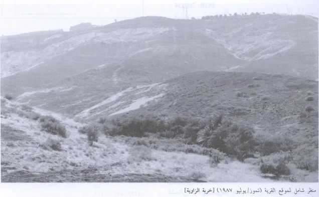
According to Walid Khalidi's field description, cactus plants grew throughout the former village site.
The site had become grazing land, while the fortress of Kawkab al-Hawa overlooked it from the northeast.
The site photograph reproduced in All That Remains dates to 1987. Khalidi's description therefore documents the historical condition of the site before the book's publication in 1992 rather than providing comprehensive direct field verification of conditions in 2026.
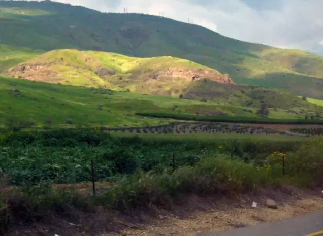
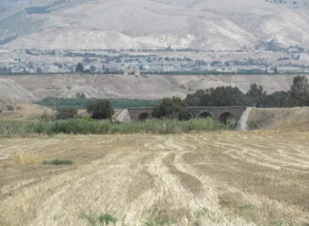
Palestine Remembered contains later community documentation, including photographs of the village lands, a Hejaz railway bridge, maps and Ottoman-era materials related to 'Arab al-Bashatwa, and an oral-history interview with Salman al-Bishtawi. These materials add valuable social and geographical context but do not replace the missing independent official statistics for the hamlet itself.
Sources
- PalQuest – Interactive Encyclopedia of the Palestine Question: Khirbat al-Zawiya
- PalQuest – Kawkab al-Hawa, for the local military chronology
- PalQuest – Operation Gideon
- Palestine Remembered – Khirbat al-Zawiya, Baysan District
- Walid Khalidi – All That Remains: Khirbat al-Zawiya
- Palestine Remembered – Oral History Interview with Salman al-Bishtawi
- Palestinian Encyclopedia – 'Arab al-Bashatwa
- Institute for Palestine Studies – All That Remains, Walid Khalidi
Photo gallery

Photos from the village's people
Photos sent in by visitors and published after review.
Add a photo of this village
Log in to add photos of this village.
Other villages from Baysan
More from the archive



 Download Our Palestine App
The whole archive in the palm of your hand: depopulated villages, the Nakba, the massacres and Al-Aqsa — free, with no ads to erase the story.
Download Our Palestine App
The whole archive in the palm of your hand: depopulated villages, the Nakba, the massacres and Al-Aqsa — free, with no ads to erase the story.



Comments
No comments yet — be the first to write one.
Add your comment
Name and email are optional. Comments appear after review.