
The depopulated village of 'Arab al-Bawati / District of Baysan

'Arab al-Bawati
About the depopulated village of 'Arab al-Bawati
- District
- Baysan
- Date 'Arab al-Bawati was occupied
- 16 May 1948
- Population in 1948
- 600
- Military operation
- Operation Gideon
- Brigade that carried it out
- Golani Brigade
- Distance from the governorate centre
- 4 (km) Northeast of Baysan
- Elevation above sea level
- -225 (m)
- Cause of displacement
- Influence of fall of, or exoduce from, neighboring town
- Extent of destruction
- The village was completely destroyed and defaced.
- Ethnic cleansing
- 'Arab al-Bawati inhabitants were completely ethnically cleansed.
Hover a dot to read the village name, or click to open its card.
Borders of the depopulated village of 'Arab al-Bawati
'Arab al-Bawati / Khirbat al-Hakamiyya / Umm al-Sharashih – Depopulated Palestinian Village of Baysan
'Arab al-Bawati was a Palestinian village in the Baysan Subdistrict, also known as Khirbat al-Hakamiyya, Umm al-Sharashih, and 'Arab al-Hakamiyya. It was founded by a branch of the 'Arab al-Ghazzawiyya Bedouin community that settled permanently in the Baysan Valley.
The village stood approximately 4 kilometers northeast of Baysan and at an average elevation of about 225 meters below sea level according to Walid Khalidi and PalQuest. Its houses extended near the Baysan-Jisr al-Majami' road and railway, while the Baysan-Tiberias highway passed to the west.
The population reached 520 in the official 1944/45 statistics. The village statistical land unit covered 10,641 dunums. Agriculture included cereals, vegetables, fruit trees, irrigated and rain-fed cultivation, livestock grazing, and fish ponds.
The villagers were displaced in May 1948 during the collapse of Palestinian control in the Baysan Valley and the advance of Golani Brigade forces. Palestinian sources differ between 16 and 20 May, so the occupation chronology requires qualification, especially because Operation Gideon formally ended on 15 May.
Basic Information
| Field | Information |
|---|---|
| Name | 'Arab al-Bawati |
| Arabic name | عرب البواطي |
| Alternative names | Khirbat al-Hakamiyya, Umm al-Sharashih, 'Arab al-Hakamiyya |
| Subdistrict | Baysan |
| Location | Northeast of Baysan in the Baysan Valley |
| Distance from Baysan | Approximately 4 km |
| Average elevation | Approximately 225 m below sea level according to PalQuest; the Palestine Encyclopedia gives about 240 m below sea level |
| Population in 1922 | 348, all Muslims |
| Population in 1931 | 461 – the figure includes al-Humud |
| Houses in 1931 | 86 – the figure includes al-Humud |
| Population in 1944/45 | 520 |
| 1948 population estimate | 603 – later estimate, not an official census |
| Total land area | 10,641 dunums |
| Depopulation date | 16 May 1948 in Palestine Remembered and broader Palestinian registers; another Palestinian source gives 20 May |
| Military context | End and immediate aftermath of Operation Gideon during the consolidation of Golani control over the Baysan Valley |
| Military unit | Golani Brigade; no village-specific battalion is securely documented |
| Cause of depopulation | Impact of Baysan's fall and subsequent military advance through the valley; the precise circumstances of each household's departure are not independently documented |
| Israeli settlements on village lands | None according to Walid Khalidi and PalQuest |
Names and Community Origins
Khalidi and PalQuest use 'Arab al-Bawati as the principal village name and record Khirbat al-Hakamiyya, Umm al-Sharashih, and 'Arab al-Hakamiyya as alternative names.
The community was established by a branch of the 'Arab al-Ghazzawiyya Bedouin tribe that settled at the site.
The principal sources reviewed do not provide a securely documented linguistic derivation of al-Bawati or Umm al-Sharashih, so no speculative etymology is introduced.
Location and Geography
'Arab al-Bawati stood northeast of Baysan in the low-lying Baysan Valley.
Khalidi describes the village as occupying a hill projecting from the eastern side of higher ground and overlooking broad areas toward the Jordan Valley.
The Palestine Encyclopedia describes the settlement as extending over relatively flat valley land near the boundary between the ghawr and zawr zones.
The houses stood east of the Baysan-Jisr al-Majami' road and railway, while the main Baysan-Tiberias highway passed to the west.
Roads and Neighboring Localities
A secondary road connected the village to neighboring communities and the main highway.
Palestinian geographical documentation records road connections with Qayta, Zab'a, al-'Ashsha, al-Hamidiyya, and al-Shaykh Salih.
The nearby city of Baysan was particularly important because villagers depended on it for commercial, educational, and administrative services.
Built Environment
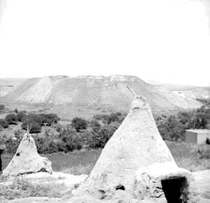
The houses of 'Arab al-Bawati were relatively dispersed across the site and were built primarily of adobe, mud brick, reeds, and cane.
A number of goat-hair tents also remained among the houses, reflecting the community's Bedouin origins even after permanent settlement.
The available PalQuest land-use table does not provide a separately documented built-up acreage, so no unsupported value is supplied.
Population
- 1922348Official Mandate-period census figure; all Muslims
- 1931461Official census figure, but PalQuest states that it includes al-Humud
- 1944/45520Official Mandate-period estimate; all inhabitants were Muslims
- 1948603Later Palestine Remembered estimate, not an official 1948 census
- 19983,704Later Palestine Remembered estimate of refugees and descendants
Palestine Remembered displays 345 for 1922, whereas the Palestine Encyclopedia and other census-based demographic material give 348. This article therefore uses 348.
Number of Houses
- 193186Official census figure, but includes al-Humud according to PalQuest
- 1948112Later Palestine Remembered estimate, not an official house census
Land Ownership, 1944/45
The Government of Palestine statistics used the original categories Arab, Jewish, and Public. Those categories are preserved here:
- Arab5,412 dunums51%
- Jewish1,305 dunums12%
- Public3,924 dunums37%
The figures balance exactly: 5,412 + 1,305 + 3,924 = 10,641 dunums.
Public land remains a distinct official category and should not be reassigned to either Arab or Jewish private ownership without separate cadastral evidence.
Land Use, 1944/45
- Arab
- Jewish
- Public
- Cereals4,399 dunums
- Plantations and irrigable land2,534 dunums
- Non-cultivable land3,708 dunums
The categories reconcile exactly with the ownership totals.
Correction to a Secondary Land-Use Table
A Palestine Remembered summary table places 3,403 dunums of cereals under the Arab column.
This equals 3,135 Arab dunums plus 268 Public dunums and therefore merges two official ownership categories.
Likewise, the displayed 3,708 non-cultivable dunums consist of only 52 Arab dunums and 3,656 Public dunums.
This article therefore follows PalQuest's more detailed breakdown and keeps the official categories separate.
Economy and Agriculture
Agriculture and livestock raising formed the economic base of 'Arab al-Bawati.
Cereals, vegetables, and fruit were cultivated, with both rain-fed and irrigated agriculture practiced.
In 1944/45, 3,135 Arab dunums were devoted to cereals and 2,225 Arab dunums to plantations or irrigable cultivation.
Other land was used for grazing, while fish ponds formed a distinctive part of the village economy.
Water
Several springs flowed in the southern part of the village and supplied water for domestic consumption and irrigation.
Agricultural production therefore relied on both rainfall and spring-fed irrigation.
Education and Services
No independent village school is documented in the principal sources reviewed.
The inhabitants relied on Baysan for educational services as well as commercial and administrative needs.
No unsupported pupil or teacher figures are therefore supplied.
Religious Buildings
The population was entirely Muslim in the Mandate-period statistics, but the principal village sources reviewed do not provide an independent description of a specific mosque or shrine at 'Arab al-Bawati.
Religious affiliation alone is not treated as sufficient evidence for a particular building.
Khirbat al-Bawati and Archaeology
Khirbat al-Bawati stood on the village site and contained visible archaeological remains.
Khalidi records ruins of walls, columns, building foundations, and Roman milestones.
The presence of Roman milestones demonstrates Roman-period remains in the landscape but does not justify dating every structure or archaeological layer at the site to the Roman period.
Operation Gideon
The Golani Brigade conducted Operation Gideon in the Baysan Valley from 10 to 15 May 1948.
The offensive resulted in the capture of Baysan and much of the surrounding subdistrict and triggered widespread Palestinian displacement.
Baysan itself fell on 12 May, followed by continued military consolidation throughout the valley.
When Was 'Arab al-Bawati Depopulated?
Palestinian sources differ on the precise date.
Palestine Remembered gives 16 May 1948, and the same date appears in broader Palestinian registers of depopulated localities.
The Palestinian Villages Encyclopedia instead gives 20 May 1948 and describes an attack followed by the expulsion of the villagers.
Operation Gideon, however, formally ended on 15 May. A 20 May event therefore cannot strictly be described as occurring within the formal dates of the operation.
This article uses 16 May as the more widely repeated Palestinian date while explicitly preserving 20 May as an alternative date rather than concealing the disagreement.
Military Unit
Palestine Remembered identifies the Golani Brigade as the attacking formation associated with 'Arab al-Bawati, consistent with Golani's central role in Operation Gideon.
The Palestinian Villages Encyclopedia adds the Irgun.
PalQuest, however, only raises the possibility that the Irgun participated somewhere in the wider Operation Gideon campaign and does not document Irgun participation specifically at 'Arab al-Bawati.
The Golani Brigade is therefore the strongest documented unit attribution. No specific battalion or Irgun unit is assigned without village-level evidence.
Cause of Depopulation
Palestine Remembered classifies the cause as the influence of the fall or exodus of a neighboring town.
The principal regional event was the fall of Baysan on 12 May and the subsequent collapse of Palestinian control throughout the valley.
Some secondary Palestinian accounts describe a direct attack and expulsion, but the surviving village-level material does not reconstruct the departure of every household in sufficient detail.
The most cautious formulation is therefore: depopulation in the context of Baysan's fall and the continuing Golani military takeover of the Baysan Valley, with the precise circumstances of all inhabitants' departure remaining incompletely documented.
Destruction
All village houses were eventually demolished after the population was displaced.
The principal sources do not provide a precise date for the demolition of every house, so the destruction should not automatically be assigned to the day of depopulation.
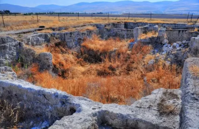
Substantial physical traces nevertheless remained, including basalt walls and square and circular building foundations.
Ethnic Cleansing in Source Classification
Palestine Remembered classifies 'Arab al-Bawati using the term “complete ethnic cleansing.” The phrase is retained here only as an attributed source classification.
The more specifically documented sequence consists of the fall of Baysan, Golani's consolidation of control over the valley, the disappearance of 'Arab al-Bawati's Palestinian population from the village in May 1948, the absence of permanent collective return, and the later demolition of the village houses.
Occupation and Depopulation Chronology
| Date | Event |
|---|---|
| 10 May 1948 | Operation Gideon begins under the Golani Brigade in the Baysan Valley. |
| 12 May 1948 | Baysan, the administrative and commercial center used by 'Arab al-Bawati's inhabitants, falls. |
| 15 May 1948 | Operation Gideon formally ends according to PalQuest. |
| 16 May 1948 | Date given by Palestine Remembered and broader Palestinian records for the depopulation of 'Arab al-Bawati. |
| 16–20 May 1948 | Golani forces continue consolidating control across the Baysan Valley in the immediate aftermath of Operation Gideon. |
| 20 May 1948 | Alternative date given by the Palestinian Villages Encyclopedia; the available evidence does not independently resolve the difference between the two dates. |
| After depopulation | The houses are demolished at an undocumented date, while walls, foundations, and agricultural features remain. |
Israeli Settlements on 'Arab al-Bawati's Lands
According to Walid Khalidi and PalQuest, no Israeli settlement was established on the lands of 'Arab al-Bawati itself.
Hamadia, the nearest settlement, was founded in 1942 west of the village before the Nakba.
It was established on land belonging to the Palestinian village of al-Hamidiyya and the town of Baysan rather than on 'Arab al-Bawati land.
Its original name was Hermonim; in 1952 it was renamed Hamadia, resembling the Arabic name al-Hamidiyya.
'Arab al-Bawati Today
According to the field description used by Walid Khalidi before the publication of All That Remains in 1992, all of the village houses had been demolished.
Remains of basalt stone walls and square and circular building foundations could still be seen among the weeds.
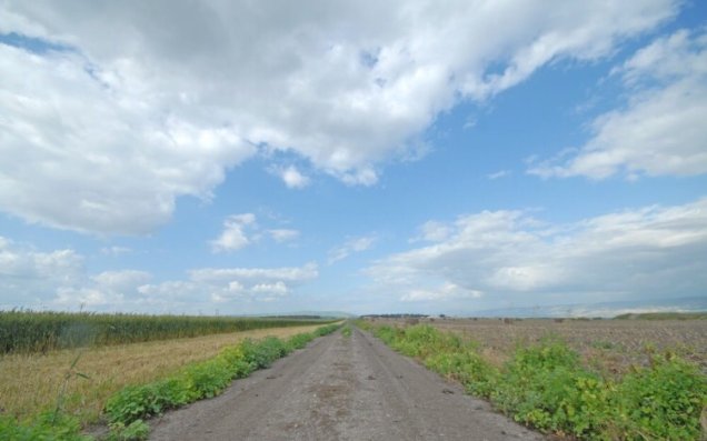
The site was fenced, while surrounding land was cultivated with a variety of crops and irrigated fields extended to the west.
The fish ponds formerly used by the Palestinian villagers also remained visible.
A field photograph associated with Khalidi's project dates to around 1990. Palestine Remembered also contains later Palestinian community photographs from 2015 showing the village remains and views toward the Jordanian highlands.
These materials constitute historical and community documentation rather than a comprehensive archaeological or cadastral field survey of the site in 2026.
Sources
- PalQuest – Interactive Encyclopedia of the Palestine Question: 'Arab al-Bawati
- PalQuest – Operation Gideon
- Palestine Remembered – 'Arab al-Bawati, Baysan Subdistrict
- Palestine Encyclopedia – 'Arab al-Bawati
- Palestinian Villages Encyclopedia – 'Arab al-Bawati / Khirbat al-Hakamiyya / Umm al-Sharashih
- Falastinuna – 'Arab al-Bawati
- Palestine Remembered – Oral history interview with Muhammad al-Bawati
- WAFA – Palestinian localities depopulated in 1948
Photo gallery
Photos from the village's people
Photos sent in by visitors and published after review.
Add a photo of this village
Log in to add photos of this village.
Other villages from Baysan

More from the archive



 Download Our Palestine App
The whole archive in the palm of your hand: depopulated villages, the Nakba, the massacres and Al-Aqsa — free, with no ads to erase the story.
Download Our Palestine App
The whole archive in the palm of your hand: depopulated villages, the Nakba, the massacres and Al-Aqsa — free, with no ads to erase the story.



Comments
No comments yet — be the first to write one.
Add your comment
Name and email are optional. Comments appear after review.