
The depopulated village of Al-Bira / District of Baysan
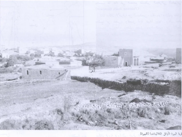
About the depopulated village of Al-Bira
- District
- Baysan
- Date Al-Bira was occupied
- 16 May 1948
- Population in 1948
- 300
- Military operation
- Operation Gideon
- Brigade that carried it out
- Golani Brigade
- Distance from the governorate centre
- 7.5 (km) North of Baysan
- Elevation above sea level
- 150 m
- Cause of displacement
- Influence of fall of, or exoduce from, neighboring town
- Extent of destruction
- al-Bira was completely destroyed, and only house walls and rubble left behind.
- Ethnic cleansing
- al-Bira inhabitants were completely ethnically cleansed.
Hover a dot to read the village name, or click to open its card.
Borders of the depopulated village of Al-Bira
Al-Bira – A Depopulated Palestinian Village in the Baysan Subdistrict
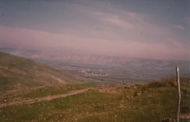
Al-Bira was a Palestinian village in the Baysan Subdistrict and should not be confused with the Palestinian city of al-Bira near Ramallah. It was situated approximately 7.5 km north of Baysan on the edge of the high hill of al-Shafa, at an average elevation of about 150 meters above sea level.
The village stood on the eastern side of a wadi running north–south until it met Wadi al-Bira to the north. Secondary roads linked al-Bira with nearby villages, including a road passing through al-Murassas before continuing south toward the main highway to Baysan.
The Iraq Petroleum Company pipeline carrying oil toward the Haifa refinery passed south of the village.
Al-Bira had 260 Arab inhabitants in 1944/45 and an official land area of 6,866 dunums. Its Palestinian population was displaced on 16 May 1948, immediately following the fall of Baysan and the Golani campaign in the valley associated with Operation Gideon.
- Subdistrict
- Baysan
- Distance from Baysan
- Approximately 7.5 km north
- Average elevation
- Approximately 150 m above sea level
- Population, 1944/45
- 260 Arabs
- Estimated population, 1948
- 302
- Total land area
- 6,866 dunums
- Date of depopulation
- 16 May 1948
- Military context
- Fall of Baysan and consolidation of control over the Baysan Valley immediately after Operation Gideon
- Military force
- Golani Brigade at campaign level; no village-specific battalion is securely identified by the principal source
- Israeli settlements on village land
- None identified by Walid Khalidi
Location and Geography
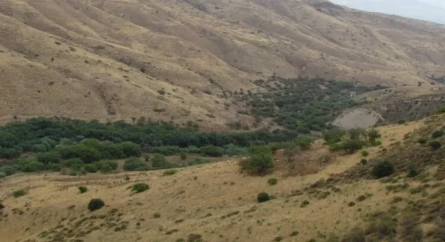
Al-Bira stood on the edge of the high hill of al-Shafa on the eastern side of a wadi running from south to north until it joined Wadi al-Bira.
Its relatively elevated position overlooked lower parts of the Baysan region, while agricultural fields and grazing land extended around the settlement.
Secondary roads linked the village with nearby communities. One passed through al-Murassas and continued south toward the main road to Baysan, which served as al-Bira's principal commercial and administrative center.
Neighboring Villages
Palestinian maps and village documentation indicate the following approximate geographical relationships:
- North: Sirin.
- West: Danna.
- Southwest: Kafra.
- Southeast: Kawkab al-Hawa.
- The road toward Baysan also passed through al-Murassas in the area south of the village.
These are approximate geographical relationships rather than substitutes for historical cadastral boundary maps.
Name and Early History
The name al-Bira has historically been associated with the meaning of a fortress or fortified place, consistent with medieval references to a strong fortress at the site.
Some scholars have proposed that al-Bira corresponds to a locality mentioned in records of Pharaoh Thutmose III's campaign in Palestine in 1468 BCE.
Other scholars have proposed an identification with an ancient place called Beer.
These identifications remain historical and archaeological proposals rather than conclusively established facts.
Al-Bira in the Islamic and Crusader Periods
Early Islamic sources provide little detail on the locality, but the Arab geographers Yaqut al-Hamawi and Abu al-Fida' later referred to al-Bira, its strong fortress, and its extensive lands.
The Crusaders referred to the locality as Loberium.
These references indicate the strategic significance of the site across different historical periods.
Al-Bira under Ottoman Rule
In 1596, al-Bira was recorded as a village in the nahiya of Shafa in the liwa' of Lajjun, with an estimated population of approximately 297.
The villagers paid taxes on wheat, barley, and olives, as well as goats, beehives, and other agricultural and pastoral production.
Built Form
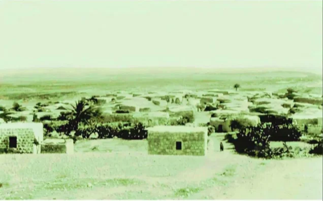
Al-Bira had a rectangular plan, and most of its houses were constructed of stone.
The 1944/45 Village Statistics classified 52 dunums as built-up land, all under the Arab category.
The village contained only a few shops, so its inhabitants relied heavily on Baysan for trade, marketing, administrative services, and other needs.
Population of Al-Bira
The 1922 Census of Palestine recorded approximately 200 inhabitants in al-Bira.
In the official 1931 census, the population had risen to 220, all Muslims, living in 53 occupied houses.
The 1944/45 Village Statistics recorded 260 Arabs.
Palestine Remembered later estimated the population at 302 in 1948 and the number of refugees and their descendants at 1,852 in 1998. These are retrospective estimates rather than official Mandate census counts.
- 1596Approximately 297Estimate derived from Ottoman tax records
- 1922200Official census
- 1931220Official census; all Muslims
- 1944/45260Official Village Statistics; all Arabs
- 1948302Later estimate, not an official census
- 19981,852 refugeesLater estimate of refugees and their descendants
Number of Houses
- 193153Occupied houses recorded in the official census
- 194872Later Palestine Remembered estimate, not an official Mandate count
Education and Public Services
Khalidi's principal village entry and the core PalQuest record do not document a separate formal school in al-Bira before the Nakba.
The same core sources do not provide clear documentation for a separate village mosque. This article therefore does not add a school or mosque without direct supporting evidence.
Al-Bira had only a few shops, and the inhabitants relied on Baysan as their main commercial and administrative center.
Land Ownership
The total land area recorded for al-Bira in the 1944/45 Village Statistics was 6,866 dunums.
Using Palestine Remembered's simplified terminology:
- Palestinian4,853 dunums71%
- Transferred to Zionists0 dunums0%
- Communal/Public2,013 dunums29%
The official Village Statistics use the original categories Arab and Public: 4,853 dunums were Arab land and 2,013 dunums were public. No land was recorded under the Jewish category.
Some later local sources give a total of 6,846 dunums. The official Village Statistics give 6,866 dunums, which is the figure used here.
Land Use in 1944/45
- Arab
- Public
- Plantations and irrigable land48 dunums
- Cereals4,681 dunums
- Built-up land52 dunums
- Non-cultivable land2,085 dunums
Cultivable land totaled 4,729 dunums, approximately 69 percent of the village area: 4,715 Arab and 14 public dunums.
Built-up and non-cultivable land totaled 2,137 dunums, approximately 31 percent: 138 Arab and 1,999 public dunums.
This corrects simplified tables that treat all 4,681 dunums of cereal land as Palestinian. The official breakdown is 4,667 Arab dunums and 14 public dunums.
Likewise, the 2,085 dunums of non-cultivable land were not all privately Palestinian; they consisted of only 86 Arab dunums and 1,999 public dunums.
Palestine Remembered also gives approximately 120 dunums of olive cultivation. This is a crop-specific figure and should not be added independently to the land-use totals above.
Economic Life
Agriculture formed the principal basis of al-Bira's economy, particularly rain-fed cereal cultivation.
In 1944/45, 4,667 Arab dunums were devoted to cereals and 48 dunums to plantations and irrigable land.
Villagers also cultivated olives and other crops, while most agriculture depended on rainfall.
Livestock raising and grazing formed another important part of the economy, and al-Bira was known for the grassy upland pastures surrounding the village.
Water, Springs, and Wadi al-Bira
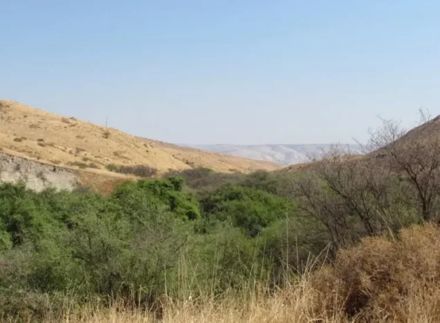
Wadi al-Bira was one of the principal natural features associated with the village and joined the wadi running alongside the settlement.
A spring lay in the valley below the village site and remained visible in Khalidi's later field description.
Agriculture depended primarily on rainfall, supplemented by local water sources in the lower ground.
The Iraq Petroleum Company Pipeline
The Iraq Petroleum Company pipeline passed south of al-Bira on its route from Iraq through Transjordan and Palestine toward the Haifa refinery.
Palestinian historical documentation includes photographs of pipeline construction south of al-Bira during the 1930s.
The pipeline was one of the most significant pieces of modern infrastructure crossing the area during the British Mandate.
Operation Gideon
The Haganah's Golani Brigade carried out Operation Gideon between 10 and 15 May 1948.
The operation was designed to take control of the Baysan Valley and displace its Palestinian inhabitants. Within days, Baysan and a number of surrounding villages fell.
PalQuest notes that the Irgun may have participated somewhere in the wider offensive because it announced on 14 May that it had taken five Arab villages in northern Palestine. The villages were not securely identified, however, and this does not establish Irgun participation at al-Bira itself.
Occupation Chronology
- 10 May 1948
Beginning of Operation Gideon
The Haganah's Golani Brigade begins the campaign to occupy the Baysan Valley and displace its Palestinian inhabitants.
- 12 May 1948
Fall of Baysan
The collapse of the district center contributes directly to flight and insecurity in surrounding villages.
- 15 May 1948
Formal end of Operation Gideon
PalQuest dates the official military-operation window from 10 to 15 May.
- 16 May 1948
Depopulation of al-Bira
Sources date the departure of al-Bira's population to this day and attribute it to the influence of Baysan's fall and the neighboring exodus.
- May 1948
Military force
The Golani Brigade carried out the wider Baysan Valley campaign; the principal village source does not identify a specific battalion that assaulted al-Bira.
- May 1948
Irgun
Possible participation is mentioned only at the wider-operation level; it cannot securely be attributed to the capture of al-Bira itself.
Depopulation of Al-Bira
The sources used here date al-Bira's depopulation to 16 May 1948.
The immediate cause recorded for the departure was the influence of the fall and exodus of nearby Baysan, the commercial and administrative center upon which the village depended.
A chronological distinction is important: PalQuest dates Operation Gideon from 10 to 15 May, while al-Bira's depopulation is dated one day later.
The most precise formulation is therefore that al-Bira was depopulated on 16 May 1948 in the immediate aftermath of Operation Gideon and the fall of Baysan, as Israeli occupation forces consolidated control over the Baysan Valley.
The principal village source does not describe a separate battle inside al-Bira on that date and does not identify a specific battalion as the village-specific assault unit.
Israeli Settlements on Village Lands
According to Walid Khalidi and PalQuest, no Israeli settlements were established on al-Bira's village lands.
Nearby settlements should therefore not be attributed to al-Bira without specific cadastral evidence.
Al-Bira Today
According to Walid Khalidi's field description in All That Remains, only the walls of houses remained at the former village site.
The site was fenced and covered with weeds, cactus, and thorny vegetation.
Fig and mulberry trees grew beside a spring in the valley below the site, while the surrounding lands were used for livestock grazing.
A documented photograph of the village site is dated 1987, so Khalidi's account should be understood as a field baseline from the 1980s rather than direct verification of conditions in 2026.
Palestine Remembered contains later Palestinian community documentation, including a photograph of Wadi al-Bira from 2005 and a photographed tour of the valley dated January 2024.
These later materials demonstrate continued Palestinian identification and visitation of the landscape, but they do not constitute a comprehensive current archaeological or architectural survey capable of establishing the exact condition of every surviving village wall or feature in 2026.
Sources
- PalQuestPalQuest – Interactive Encyclopedia of the Palestine Question: al-Bira, Baysan
- PalQuestPalQuest – Operation Gideon
- Palestine RememberedPalestine Remembered – al-Bira, Baysan
- Palestine RememberedPalestine Remembered – al-Bira entry from All That Remains
- Institute for Palestine StudiesInstitute for Palestine Studies – Walid Khalidi, All That Remains
- pcbs.gov.psGovernment of Palestine – Census of Palestine 1922
- pcbs.gov.psGovernment of Palestine – Census of Palestine 1931: Beisan Sub-District
- maktabatsabil.comGovernment of Palestine – Village Statistics 1945: Beisan Sub-District, Population and Land Ownership
- maktabatsabil.comGovernment of Palestine – Village Statistics 1945: Beisan Sub-District, Cultivable Land
- palqura.comPalestinian Villages Encyclopedia – al-Bira, Baysan
Photo gallery





Photos from the village's people
Photos sent in by visitors and published after review.
Add a photo of this village
Log in to add photos of this village.
Other villages from Baysan

More from the archive



 Download Our Palestine App
The whole archive in the palm of your hand: depopulated villages, the Nakba, the massacres and Al-Aqsa — free, with no ads to erase the story.
Download Our Palestine App
The whole archive in the palm of your hand: depopulated villages, the Nakba, the massacres and Al-Aqsa — free, with no ads to erase the story.



Comments
No comments yet — be the first to write one.
Add your comment
Name and email are optional. Comments appear after review.