
The depopulated village of Al-Hamidiyya / District of Baysan
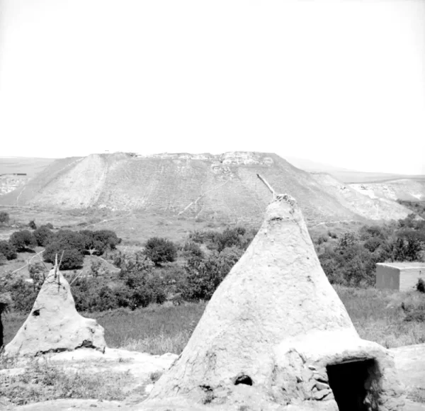
Al-Hamidiyya
About the depopulated village of Al-Hamidiyya
- District
- Baysan
- Date Al-Hamidiyya was occupied
- 12 May 1948
- Population in 1948
- 260
- Military operation
- Operation Gideon
- Brigade that carried it out
- Golani Brigade
- Distance from the governorate centre
- 5 (km) North of Baysan
- Elevation above sea level
- -10 m
- Cause of displacement
- Influence of fall of, or exoduce from, neighboring town
- Extent of destruction
- al-Hamidiyya was completely destroyed, only house rubble and cemetery left behind.
- Ethnic cleansing
- al-Hamidiyya inhabitants were completely ethnically cleansed.
- Settlements built on the land of Al-Hamidiyya before 1948
- Irgun Dror (Abandoned)
Hover a dot to read the village name, or click to open its card.
Borders of the depopulated village of Al-Hamidiyya
Al-Hamidiyya – A Depopulated Palestinian Village in the Baysan Subdistrict
Al-Hamidiyya was a Palestinian village in the Baysan Subdistrict, situated approximately 5 km north of the town of Baysan on a hill overlooking the Baysan Valley to the east and Wadi Yubla to the north, at an average elevation of about 10 meters below sea level.
The village relied on Baysan for administrative and commercial services. A secondary road approximately two kilometers long linked it with the main road to Baysan, while other local roads connected it with neighboring villages.
The Palestinian inhabitants of al-Hamidiyya left on 12 May 1948 during the wider Golani campaign in the Baysan Valley associated with Operation Gideon. Khalidi states that the departure occurred under the influence of the exodus from Baysan and under “Haganah pressure,” although the nature of that pressure is not specified and his village account does not describe a detailed direct assault on al-Hamidiyya that day.
- Subdistrict
- Baysan
- Distance from Baysan
- Approximately 5 km north
- Average elevation
- Approximately 10 m below sea level
- Population, 1931
- 157
- Palestinian population, 1944/45
- 220 Arabs
- Total population in the 1944/45 statistical row
- 320: 220 Arabs in al-Hamidiyya and 100 Jews in Hermonim
- Estimated Palestinian population, 1948
- 255
- Total statistical land unit
- 10,902 dunums; includes al-Hamidiyya and Hermonim
- Date of depopulation
- 12 May 1948
- Military operation
- Operation Gideon
- Military force
- Golani Brigade at the wider campaign level; no village-specific battalion is identified in the principal source
- Israeli settlements on village land
- Khalidi identifies no settlement as founded directly on al-Hamidiyya's land; Hermonim/Chamadya was nearby but not on village land
Location and Geography
Al-Hamidiyya stood on a hill overlooking the Baysan Valley to the east, Wadi Yubla to the north, and lands belonging to the town of Baysan to the south.
The village formed part of the fertile agricultural landscape surrounding Baysan, where soils and water resources supported cereals, vegetables, citrus, and other crops.
A secondary road approximately two kilometers long connected al-Hamidiyya with the highway leading to Baysan, while additional local roads linked it to neighboring Palestinian villages.
Neighboring Villages and Areas
Palestinian maps and community documentation indicate the following approximate geographical relationships:
| Direction | Village or Area |
|---|---|
| North | Jabbul |
| Northeast | Zab'a |
| East | 'Arab al-Bawati / Khirbat al-Hakimiyya |
| South | Baysan and its lands |
| West | al-Murassas |
These are approximate geographical relationships and should not be treated as substitutes for historical cadastral boundaries.
Name of Al-Hamidiyya
The village was named after Ottoman Sultan 'Abd al-Hamid II, who ruled from 1876 to 1909.
The name therefore reflects the village's association with the late Ottoman period in the Baysan region.
Built Form
Al-Hamidiyya had a rectangular layout with narrow lanes intersecting to form a local street grid.
The older houses were constructed of adobe brick, while newer houses built during the first half of the twentieth century used cement and were erected along roads leading toward neighboring villages.
The Palestine Index Gazetteer classified al-Hamidiyya as a hamlet or agricultural settlement.
Population of Al-Hamidiyya
The official 1922 Census of Palestine recorded 193 inhabitants. Census data list 192 Muslims and one Roman Catholic Christian.
By the 1931 census, the population stood at 157, all Muslims, living in 42 occupied houses.
The 1944/45 Village Statistics require particular care because al-Hamidiyya and the nearby Jewish settlement of Hermonim were combined in one statistical row. The row records 220 Arabs in al-Hamidiyya and 100 Jews in Hermonim, producing a statistical total of 320.
The Palestinian village population itself was therefore 220, not 320.
Palestine Remembered later estimated the Palestinian population at 255 in 1948 and the number of refugees and their descendants at 1,567 in 1998. These are retrospective estimates rather than official Mandate census counts.
- 1922193Official census; 192 Muslims and one Roman Catholic Christian
- 1931157Official census; all Muslims
- 1944/45220 ArabsPalestinian population of al-Hamidiyya; the full statistical row also records 100 Jews at Hermonim, total 320
- 1948255Later estimate of the Palestinian population, not an official census
- 19981,567 refugeesLater estimate of refugees and their descendants
Number of Houses
- 193142Occupied houses recorded in the official census
- 194868Later Palestine Remembered estimate, not an official Mandate count
Education
Khalidi's principal village account and the core PalQuest entry do not document a separate formal school in al-Hamidiyya.
This article therefore does not add a school without a secure source, particularly because the village depended on nearby Baysan for a number of administrative and commercial services.
Maqam Khalid
A shrine known as Maqam Khalid stood in the northeastern part of the village and was associated with a local Muslim holy man.
The principal source does not provide a secure construction date or a detailed architectural history of the shrine.
The Al-Hamidiyya Cooperative Society
Palestinian community documentation preserves records relating to the Al-Hamidiyya Cooperative Credit and Thrift Society during the 1940s.
The surviving material includes budgets, profit-and-loss accounts, and official correspondence from 1943–1947, demonstrating organized financial and cooperative activity in the village in the final years before the Nakba.
Land Ownership in 1944/45
The combined statistical unit of al-Hamidiyya and Hermonim contained 10,902 dunums.
Using Palestine Remembered's simplified terminology:
- Palestinian4,814 dunums44%
- Transferred to Zionists1,386 dunums13%
- Communal/Public4,702 dunums43%
The official Village Statistics use the original categories Arab, Jewish, and Public: 4,814 dunums were Arab land, 1,386 Jewish, and 4,702 public.
These figures belong to a statistical unit that combined al-Hamidiyya and Hermonim; they should therefore not be represented as a standalone cadastral total belonging exclusively to the Palestinian village.
Some Palestine Remembered versions display 4,720 dunums of public land, but that figure is inconsistent with the published 10,902-dunum total. The official Village Statistics give 4,702 dunums, which is used here.
Land Use in 1944/45
The official 1945 land-use tables contain an internal numerical discrepancy for al-Hamidiyya and Hermonim. The figures are therefore reproduced as published and the conflict is stated explicitly rather than silently “corrected.”
- Arab
- Jewish
- Public
- Published Total
- Citrus and bananas328 dunums
- Plantations and irrigable land24 dunums
- Cereals13,100 dunums
- Built-up land100 dunums
- Non-cultivable land8,580 dunums
The official cultivable-land table gives a total of 6,726 dunums: 4,567 Arab, 1,293 Jewish, and 866 public.
The built-up and non-cultivable table gives 4,340 dunums: 411 Arab, 93 Jewish, and 3,836 public.
Adding those published totals produces 11,066 dunums, which exceeds the official ownership total of 10,902 dunums by 164 dunums—the exact area listed for citrus and bananas.
The official sources used here provide no clear explanation for this discrepancy, so this article does not remove or reclassify the 164 dunums without evidence.
Some simplified Palestine Remembered tables also merge public land into the Palestinian column. For cereals, for example, the official breakdown is 4,395 Arab, 1,289 Jewish, and 866 public dunums, rather than 5,261 Palestinian and 1,289 Jewish dunums.
The same applies to non-cultivable land: the official figures are 401 Arab, 53 Jewish, and 3,836 public dunums.
Economic Life
Agriculture formed the principal basis of the economy.
Villagers cultivated cereals, vegetables, citrus fruit, and bananas, as well as a small area of plantations and irrigated land.
In 1944/45, the official table records 164 Arab dunums of citrus and bananas, 4,395 Arab dunums of cereals, and 8 Arab dunums of plantations and irrigable land.
The village depended on Baysan for administrative services, trade, and the marketing of agricultural produce.
Documents concerning the local cooperative credit and thrift society also show a degree of organized financial activity during the final years of the Mandate.
Water and Wadis
Al-Hamidiyya overlooked the Baysan Valley to the east and Wadi Yubla to the north.
Other Palestinian geographical descriptions record wadis crossing the northern and southern parts of its wider lands and flowing eastward toward the Jordan River.
Khalidi does not provide a detailed list of village springs, although several wells remained identifiable at the site after the Nakba.
Operation Gideon
Operation Gideon ran from 10 to 15 May 1948 and was carried out by the Haganah's Golani Brigade to establish control over the Baysan Valley and displace its Palestinian population.
The campaign led to the fall of Baysan and the occupation or depopulation of much of the surrounding valley within a few days.
Later Palestinian documentation places al-Hamidiyya within the Operation Gideon context. Khalidi's village-specific account describes the village's departure within the wider Golani offensive against Baysan and its valley but does not identify a specific Golani battalion as the unit that entered al-Hamidiyya.
PalQuest's Operation Gideon account notes that the Irgun may have participated somewhere in the wider offensive on the basis of its own announcement that it had occupied five northern villages. This does not establish Irgun participation at al-Hamidiyya itself, so the Irgun is not listed here as the village-specific attacking unit.
Depopulation on 12 May 1948
Al-Hamidiyya was among the few villages in the Baysan Valley whose inhabitants remained until the collapse of the district center.
Khalidi records that the villagers departed on 12 May 1948 under the influence of the exodus from Baysan and under “pressure from the Haganah.”
The account does not specify what form this pressure took and does not provide a detailed description of a direct battle or assault inside the village on that date.
The most precise formulation is therefore that al-Hamidiyya was depopulated on 12 May 1948 under the impact of Baysan's fall and Haganah pressure, within the broader Golani campaign associated with Operation Gideon.
- 10 May 1948
Beginning of Operation Gideon
Golani Brigade begins the campaign to occupy the Baysan Valley
- 12 May 1948
Fall of Baysan and regional flight
Collapse of the district center directly affects surrounding Palestinian communities
- 12 May 1948
Depopulation of al-Hamidiyya
Villagers leave under the influence of the exodus from Baysan and Haganah pressure
- May 1948
Military force
Golani Brigade at the wider campaign level; no village-specific battalion securely identified
- 15 May 1948
End of Operation Gideon
Completion of the principal campaign in the Baysan Valley
Demolition after Depopulation
In September 1948, nearby Zionist settlements requested authorization from the Israeli authorities to demolish al-Hamidiyya and three other villages in the region.
The account cited by Khalidi does not establish whether formal permission was granted or the precise date on which al-Hamidiyya was destroyed.
No exact demolition date is therefore assigned here without additional reliable documentation.
Hermonim / Chamadya and Al-Hamidiyya
Hermonim: Established in 1942 approximately two kilometers south of the al-Hamidiyya village site.
According to Khalidi, Hermonim stood close to al-Hamidiyya's lands but was not established on the village's lands.
In 1952, Hermonim was renamed Chamadya, a name selected to resemble the Arabic name al-Hamidiyya.
This geographical distinction should not be confused with the 1945 statistical tables, which combined al-Hamidiyya and Hermonim into a single statistical unit and consequently recorded 100 Jewish residents and 1,386 dunums of Jewish-owned land. Statistical aggregation does not by itself mean that the settlement was founded on al-Hamidiyya's village land.
Al-Hamidiyya Today
According to Walid Khalidi's field description in All That Remains, the remains of village houses had been reduced to cement and stone rubble, while the cemetery and several wells remained identifiable.
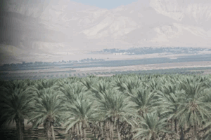
Thorny vegetation covered much of the site, and the surrounding lands were being used for agriculture and livestock grazing.
A documented photograph reproduced in the village archive is dated 1987 and shows the ruins of the destroyed village.
Khalidi's description should therefore be treated as a field baseline from the 1980s and the period before the publication of All That Remains in 1992, not as direct verification of every feature in 2026.
Palestine Remembered also contains later community documentation of the village site, the old railway, and surrounding lands. Such material is useful for tracing later landscape change but does not constitute a comprehensive current archaeological or architectural survey, and an upload date does not necessarily establish the date on which a photograph was taken.
Sources
- PalQuestPalQuest – Interactive Encyclopedia of the Palestine Question: al-Hamidiyya
- PalQuestPalQuest – Operation Gideon
- Palestine RememberedPalestine Remembered – al-Hamidiyya, Baysan
- Palestine RememberedPalestine Remembered – al-Hamidiyya entry from All That Remains
- Institute for Palestine StudiesInstitute for Palestine Studies – Walid Khalidi, All That Remains
- pcbs.gov.psGovernment of Palestine – Census of Palestine 1922
- pcbs.gov.psGovernment of Palestine – Census of Palestine 1931: Beisan Sub-District
- maktabatsabil.comGovernment of Palestine – Village Statistics 1945: Beisan Sub-District, Population and Land Ownership
- maktabatsabil.comGovernment of Palestine – Village Statistics 1945: Beisan Sub-District, Cultivable Land
- sabil.meGovernment of Palestine – Village Statistics 1945: Built-up and Non-Cultivable Land
- palqura.comPalestinian Villages Encyclopedia – al-Hamidiyya
Photo gallery


Photos from the village's people
Photos sent in by visitors and published after review.
Add a photo of this village
Log in to add photos of this village.
Other villages from Baysan

More from the archive


 Download Our Palestine App
The whole archive in the palm of your hand: depopulated villages, the Nakba, the massacres and Al-Aqsa — free, with no ads to erase the story.
Download Our Palestine App
The whole archive in the palm of your hand: depopulated villages, the Nakba, the massacres and Al-Aqsa — free, with no ads to erase the story.



Comments
No comments yet — be the first to write one.
Add your comment
Name and email are optional. Comments appear after review.