
The depopulated village of Qumya / District of Baysan
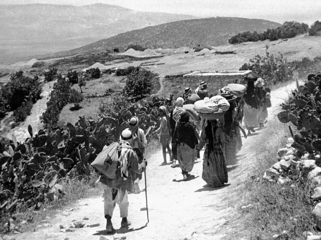
About the depopulated village of Qumya
- District
- Baysan
- Date Qumya was occupied
- 26 March 1948
- Population in 1948
- 510
- Distance from the governorate centre
- 12.5 km northwest of Baysan
- Elevation above sea level
- 75 m
- Cause of displacement
- Fear of a Zionist attack, a sense of vulnerability and economic pressures, amid the Jewish National Fund's push to expel the inhabitants, according to Morris as cited by Khalidi; followed by the eviction of the men who had stayed behind to guard the village
- Extent of destruction
- The village was completely destroyed and only the village schools remain standing.
- Ethnic cleansing
- On March 26th, 1948, Qumya was ethnically cleansed based on the orders of Yosef Weitz (a Jewish National Fund official). Weitz wrote in his diary about the inhabitants of Qumya and al-Tira in the Baysan valley
- Settlements built on the land of Qumya before 1948
- En Charod, established in 1921 on what was traditionally village land south of the village site
- Settlements built on the built-up area of Qumya after 1948
- Since En Charod's division in the early 1950s, En Charod-Ichud has stood on Qumya's land
Hover a dot to read the village name, or click to open its card.
Borders of the depopulated village of Qumya
Qumya: A Depopulated Palestinian Village in the Baysan District
Qumya was a depopulated Palestinian village in the Baysan District, located approximately 12.5 kilometers northwest of the town of Baysan on a hilltop at an average elevation of about 75 meters above sea level. Together with the neighboring village of Shatta, it was regarded as one of the western gateways to the Baysan plain, while the Baysan–Haifa highway passed along the outskirts of the village.
- Subdistrict
- Baysan
- Distance from district center
- 12.5 km northwest of Baysan
- Average Elevation
- 75 m above sea level
- Population in 1931
- 386
- Number of Houses in 1931
- 88
- Population in 1944/1945
- 440
- Estimated Population in 1948
- About 510 – a later demographic estimate, not an official census
- Total Land Area in 1945
- 4,898 dunams
- Attack and Depopulation
- On 26 March 1948 Yosef Weitz, director of the Jewish National Fund's Lands Department, called for the expulsion of the villagers, and on the same day most of them left on British army trucks out of fear of a Zionist attack, a sense of vulnerability and economic pressures, according to Morris as cited by Khalidi; about a dozen men who had stayed behind to guard the village were subsequently evicted.
- Final Israeli Control
- The sources give no date for a military occupation of the village; most of its inhabitants left on 26 March 1948 (30 March according to the Israeli intelligence report dated 30 June 1948), and those who remained were evicted at a later, unspecified date
- Cause of Depopulation
- Fear of a Zionist attack, a sense of vulnerability and economic pressures, amid the Jewish National Fund's push to expel the inhabitants, according to Morris as cited by Khalidi; followed by the eviction of the men who had stayed behind to guard the village
- Settlements Documented on Village Lands
- En Charod, established in 1921 on what was traditionally village land south of the village site; since its division in the early 1950s, En Charod-Ichud has stood on Qumya's land
The Government of Palestine's 1944/1945 statistics recorded 440 inhabitants, all Muslims, and a total land area of 4,898 dunums. During the Nakba and the occupation of Palestine in 1948, most of Qumya's inhabitants left on 26 March amid fear of a Zionist attack, a sense of isolation and vulnerability, and economic pressures, while officials of the Jewish National Fund were simultaneously pressing for the village's evacuation. About twelve men who remained behind to guard Qumya were subsequently expelled.
Location of Qumya
- Qumya was located approximately 12.5 kilometers northwest of Baysan.
- Its average elevation was about 75 meters above sea level.
- The village stood on a hilltop at the western edge of the Baysan plain.
- Qumya and Shatta were considered western gateways to the Baysan plain.
- The Baysan–Haifa highway passed along the outskirts of the village.
- Its lands bordered those of al-Tayyiba, Yubla, al-Murassas, Shatta, and other agricultural areas.
Qumya Through History
In 1596, Qumya lay within the administrative jurisdiction of the liwa' of Lajjun and was recorded as a farm that paid taxes to the Ottoman government.
By the late nineteenth century, Qumya was described as a village situated on a knoll in the middle of a valley and surrounded by gardens of prickly pear.
Its adobe houses were densely clustered on the hilltop, while vegetable gardens spread across the lower surrounding slopes.
The Built Environment of Qumya
Qumya's houses formed a compact cluster on the hilltop and were largely constructed of adobe. Agricultural fields, vegetable gardens, and prickly pear surrounded the built-up area.
The built-up area covered approximately 15 dunums according to the 1944/1945 statistics.
Education in Qumya
Qumya had an elementary school for boys, the principal educational institution documented in the main sources for the village before the Nakba.
The principal sources used here do not provide a firmly documented date of establishment or an official enrollment figure, so unsupported details are not added.
Population of Qumya
The official 1922 Census of Palestine recorded 401 inhabitants in Qumya, all Muslims.
In the 1931 census, the village had 386 inhabitants, including 184 males and 202 females. All were Muslims, and they lived in 88 houses.
The Government of Palestine's 1944/1945 statistics recorded 440 inhabitants.
The figures of 510 inhabitants for 1948 and 3,134 refugees for 1998 published by Palestine Remembered are later estimates and are not official Government of Palestine censuses.
Population of Qumya
- 1922401Official census; all inhabitants were Muslims
- 1931386Official census; all inhabitants were Muslims
- 1944/1945440Government of Palestine statistics
- 1948510Later estimate published by Palestine Remembered
- 19983,134Later refugee-population estimate published by Palestine Remembered
Number of Houses in Qumya
The 1931 census recorded 88 houses in Qumya.
The figure of 116 houses for 1948 published by Palestine Remembered is a later estimate rather than an official Government of Palestine census figure.
Number of Houses in Qumya
- 193188Official census
- 1948116Later estimate published by Palestine Remembered
Land Ownership in Qumya
The total land area recorded for Qumya in the 1944/1945 statistics was 4,898 dunums.
The Arabic Palestine Remembered table uses the categories “Palestinian,” “Transferred to Zionists,” and “Masha'.” These terms are preserved below to reflect the terminology used by that source. The Government of Palestine statistics use the official categories “Arab,” “Jewish,” and “Public.”
Land Ownership in Qumya, 1944/1945, Using the Terminology of Palestine Remembered
- Palestinian4,716 dunums96%
- Transferred to Zionists81 dunums2%
- Masha' (source terminology)101 dunums2%
Land Use in Qumya in 1944/1945
Most of Qumya's lands were cultivated or classified as cultivable. A total of 4,319 dunums fell into this category, consisting of 4,238 dunums of Arab land and 81 dunums of Jewish land.
Cereal cultivation covered 4,286 dunums, including 4,205 dunums of Arab land and 81 dunums of Jewish land. Plantations and irrigable land covered another 33 dunums, all Arab land.
Land Use in Qumya According to the 1944/1945 Statistics
- Arab
- Jewish
- Public
- Plantations and Irrigable Land33 dunums
- Cereals4,286 dunums
- Built-up Area15 dunums
- Non-Cultivable Land564 dunums
Economic Life in Qumya
Qumya's economy depended primarily on agriculture, particularly cereal and vegetable cultivation.
Vegetable gardens spread across the lower slopes surrounding the village hill, while cereals occupied the overwhelming majority of cultivated land.
Its position on the western edge of the Baysan plain and its proximity to the Baysan–Haifa highway also connected the villagers with nearby towns and markets.
Archaeological Sites in Qumya
Qumya and the surrounding area were known for several archaeological sites and ancient remains.
Khirbat Qumya contained rectangular foundations, caves, and rock-hewn water cisterns. The village site itself yielded the remains of a rectangular building, architectural fragments, and dressed or bossed stones, indicating occupation during earlier historical periods.
Approximately 800 meters south of Qumya was the archaeological site of 'Ayn Jalud, where remains associated with Roman roads, including milestones, and a large rock-cut pool were found.
Pressure on Qumya Before Its Depopulation
Qumya's depopulation was not the result of a battle during a major military offensive such as Operation Gideon. Instead, it took place during an earlier phase of the Nakba, more than a month before that operation began.
According to Walid Khalidi and PalQuest, the Jewish National Fund, particularly its Lands Department director Yosef Weitz, played an active role in efforts to bring about the evacuation of several Palestinian villages in the area.
On 26 March 1948, Weitz met with other JNF officials and called for the removal of the inhabitants of Qumya and neighboring al-Tira, claiming that they were not preventing the movement of Arab irregular fighters through the area.
The details concerning Weitz and Israeli accounts of the episode are presented here through the Palestinian intermediary source Khalidi/PalQuest rather than through independent reliance on Israeli sources.
The Depopulation of Qumya on 26 March 1948
Most of Qumya's inhabitants left the village on 26 March 1948, more than six weeks before Operation Gideon began in the Baysan Valley.
Walid Khalidi, citing Israeli historian Benny Morris, states that the villagers left because of fear of a Jewish attack, a sense that their village had become exposed and vulnerable, and economic pressures whose nature the cited source does not specify.
The account states that the inhabitants left aboard British army trucks. It also says that their Jewish neighbors did not formally order them to leave, although they may have received what the cited account described as “friendly advice” to do so.
About twelve men remained behind to guard Qumya after most of its population had left, but they were subsequently evicted as well.
An Israeli intelligence report dated 30 June 1948 and published by PalQuest likewise recorded Qumya as fully evacuated, citing isolation, lack of work, and transportation difficulties among the factors involved. It listed Baysan, Nazareth, and Transjordan among the destinations of the displaced villagers.
Occupation and Depopulation Chronology
- 26 March 1948
Call for the expulsion of the inhabitants
Yosef Weitz, director of the Jewish National Fund's Lands Department, met other JNF officials and called for the expulsion of the inhabitants of Qumya and neighbouring al-Tira, on the grounds that they were 'not taking upon themselves the responsibility of preventing the infiltration of irregulars' and that 'they must be forced to leave their village until peace comes', according to Morris as cited by Khalidi.
- 26 March 1948 (30 March according to the Israeli intelligence report)
Depopulation of the village
Most of the inhabitants left the village on British army trucks that same day, out of fear of a Zionist attack, a sense of vulnerability and economic pressures, according to Morris as cited by Khalidi; a few days later Weitz wrote that Qumya had been depopulated. The Israeli intelligence report dated 30 June 1948, as published by PalQuest, dates the village's full evacuation to 30 March, attributes it to isolation among Jews and a lack of transportation and work, and gives Baysan, Nazareth and Transjordan as the inhabitants' destinations.
- After 26 March 1948 (date not specified)
Expulsion of the remaining inhabitants
About a dozen men who had stayed behind to guard the village were subsequently evicted, according to Khalidi; the sources specify neither the date of their eviction nor who carried it out.
- Late July 1948
Application to seize the village lands
The neighbouring Kibbutz En Charod applied to the Israeli Agriculture Center for permission to seize Qumya's land; Morris, as cited by Khalidi, does not make clear whether the request was approved.
Was Qumya Depopulated During Operation Gideon?
No. Some abbreviated tables, including one on Palestine Remembered, place the designation “Operation Gideon” and the Golani Brigade alongside the date 26 March 1948. These entries cannot be reconciled chronologically.
Operation Gideon began on 10 May 1948 and ended on 15 May. It was carried out by the Haganah's Golani Brigade to occupy the Baysan Valley and depopulate its Palestinian communities.
Most inhabitants of Qumya, however, had already left on 26 March, approximately a month and a half before Operation Gideon began. PalQuest's own list of villages directly affected by Operation Gideon does not include Qumya.
Qumya's March depopulation is therefore not attributed here to Operation Gideon or to a Golani assault, but to the earlier process of pressure, fear, isolation, and evacuation documented by Khalidi and PalQuest.
Attempts to Appropriate Qumya's Lands After Depopulation
Approximately four months after Qumya was depopulated, the neighboring kibbutz of En Charod applied to the Israeli Agriculture Center in late July 1948 for permission to take possession of the village's lands.
Walid Khalidi, citing Benny Morris, records the application but notes that the cited source does not make clear whether formal approval was granted.
Settlements on the Lands of Qumya
Zionist settlement on land traditionally belonging to Qumya began decades before the Nakba.
- En Charod: established in 1921 on land traditionally belonging to Qumya, south of the village site.
- En Charod-Ihud: created when En Charod was divided in the early 1950s and located on Qumya's lands.
- En Charod-Me'uhad: created through the same division but located on land belonging to the still-existing Palestinian village of Tamra, not Qumya.
- Geva': established in 1921 approximately two kilometers west of Qumya but not on village land.
Walid Khalidi therefore does not identify a wholly new, separately founded settlement established specifically on Qumya's site after the Nakba. Rather, En Charod had already been established on part of its traditional lands before 1948 and was later divided.
The Site of Qumya After the Nakba
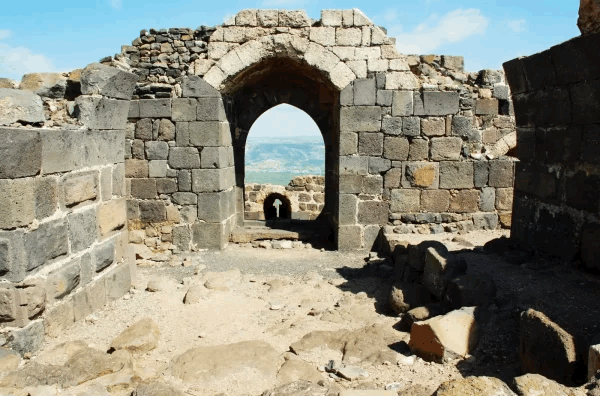
According to Walid Khalidi's field description, the entire site of Qumya was fenced, with rubble scattered across the former village.
Almond, mulberry, and pomegranate trees and cactuses grew around the ruins, while cypress trees stood among the remains of the village school.
Khalidi recorded that residents of Tel Yosef, En Charod-Ihud, and En Charod-Me'uhad cultivated land south of the former village site, while residents of Geva' cultivated land to the west.
This description is based on fieldwork conducted for Walid Khalidi's All That Remains and should not necessarily be treated as an updated field survey of the site today.
Sources
- PalQuestPalQuest – Interactive Encyclopedia of the Palestine Question: Qumya
- PalQuestPalQuest – Interactive Encyclopedia of the Palestine Question: Operation Gideon
- PalQuestPalQuest: Israeli Intelligence Report on the Depopulation of Palestine, 30 June 1948
- Institute for Palestine StudiesInstitute for Palestine Studies: Walid Khalidi, All That Remains
- Palestine RememberedPalestine Remembered: Qumya – Baysan District
- pcbs.gov.psGovernment of Palestine: Census of Palestine, 1922, hosted by the Palestinian Central Bureau of Statistics
- pcbs.gov.psGovernment of Palestine: Census of Palestine, 1931 – Baysan Sub-District
Photo gallery


Photos from the village's people
Photos sent in by visitors and published after review.
Add a photo of this village
Log in to add photos of this village.
Other villages from Baysan
More from the archive



 Download Our Palestine App
The whole archive in the palm of your hand: depopulated villages, the Nakba, the massacres and Al-Aqsa — free, with no ads to erase the story.
Download Our Palestine App
The whole archive in the palm of your hand: depopulated villages, the Nakba, the massacres and Al-Aqsa — free, with no ads to erase the story.



Comments
No comments yet — be the first to write one.
Add your comment
Name and email are optional. Comments appear after review.