
The depopulated village of Barqa / District of Gaza
About the depopulated village of Barqa
- District
- Gaza
- Date Barqa was occupied
- 13 May 1948
- Population in 1948
- 1,030
- Military operation
- Operation Barak
- Brigade that carried it out
- Givati Brigade
- Distance from the governorate centre
- 37 (km) North East of Gaza
- Elevation above sea level
- 25 m
- Cause of displacement
- Military assault by Zionist troops
- Extent of destruction
- The village was completely destroyed with the exception of two houses remain standing.
- Ethnic cleansing
- Barqa inhabitants were completely ethnically cleansed.
- Settlements built on the built-up area of Barqa after 1948
- Gan Yavne expansion
Hover a dot to read the village name, or click to open its card.
Borders of the depopulated village of Barqa
Barqa – Gaza Subdistrict
Barqa was a depopulated Palestinian village in the Gaza subdistrict, situated on level ground in the coastal plain approximately 37 km north of Gaza at an average elevation of about 25 meters. Walid Khalidi places the village about 7 km from the Mediterranean coast. A secondary road connected it with the main coastal highway running between Gaza and Jaffa.
The official 1931 Census of Palestine recorded 600 inhabitants, while the 1944/45 statistics recorded 890. The registered village lands covered 5,206 dunums. Barqa's population was displaced during an attack by the Haganah's Giv'ati Brigade between 10 and 13 May 1948, in the context of Operation Barak.
Location of Barqa
Barqa stood on flat ground in the coastal plain, east of the belt of coastal sand dunes. A secondary road linked it to the Gaza–Jaffa coastal highway, providing access to Gaza, Isdud, Jaffa, and neighboring villages.
This article follows PalQuest and Khalidi in placing the village approximately 37 km from Gaza and at an elevation of about 25 meters. Some later Palestinian reference works give different distances and elevations, but the core village source is preferred where the figures conflict.
Boundaries and Neighboring Villages
Palestinian local documentation and village maps place Barqa among the following surrounding localities:
| Direction | Neighboring village / area |
|---|---|
| North and northeast | Bashshit |
| East | Yasur |
| Southeast | al-Batani al-Sharqi |
| South | al-Batani al-Gharbi |
| Southwest | Isdud |
| West and northwest | 'Arab Suqrir / Abu Suwayrih |
Original cadastral maps remain the best evidence for distinguishing a precise land boundary from general geographical proximity.
Name and Earlier History of the Site
Walid Khalidi considers it possible that Barqa stood on the site of an older settlement known as Barka in Greek sources and Bareca under the Romans.
This identification is a historical possibility rather than conclusive archaeological proof of uninterrupted settlement between the ancient locality and the modern Palestinian village.
Archaeological traces recorded at the village included an old well, carved stones or inscriptions, and pottery fragments, indicating earlier use of the site.
Built Environment
Barqa had an irregular layout. Most of its houses were built of adobe brick, stood close together, and were separated by narrow alleys.
Several small shops stood in the village center. The mosque was another principal landmark, with a number of shrines and tombs associated with local religious traditions nearby.
In the 1944/45 statistics, 26 dunums of built-up land were classified as Arab and 8 as Jewish, producing a total built-up category of 34 dunums for the statistical land unit.
A figure of 226 dunums sometimes repeated as the village's built-up area is not supported by the official table; 226 dunums was instead the total land area registered in the Jewish ownership category.
Population of Barqa
- 1922448Official Census of Palestine; all enumerated residents were Muslims
- 1931600Official census: 593 Muslims, 6 Jews, and 1 Christian
- 1944/45890Official Mandate-era statistics; all 890 were recorded in the Arab population category
- 19481,032Later estimate published by Palestine Remembered; not an official census
- 19986,340 refugees and descendantsLater Palestine Remembered estimate; a local study gives the very similar figure of 6,346
The figure of 593 sometimes presented as Barqa's entire 1931 population is only the Muslim population. The official census total was 600.
Number of Houses
- 1931123 occupied housesOfficial Census of Palestine
- 1948211Later estimate published by Palestine Remembered; not an official census figure
Land Ownership
Barqa's registered lands totaled 5,206 dunums in the 1944/45 statistics. Palestine Remembered presents the simplified ownership categories as follows:
- Palestinian4,841 dunums93%
- Transferred to Zionists226 dunums4%
- Communal/Public139 dunums3%
The official Village Statistics use the original categories Arab, Jewish, and Public, recording 4,841 Arab dunums, 226 Jewish dunums, and 139 Public dunums.
Land Use in 1944/45
- Arab
- Jewish
- Public
- Citrus and bananas667 dunums
- Plantations and irrigable land47 dunums
- Cereals4,031 dunums
- Built-up land34 dunums
- Non-cultivable land427 dunums
The categories balance exactly with the official ownership totals.
Palestine Remembered's simplified display places 342 dunums of non-arable land in its Palestinian column. The official breakdown shows that this figure combines 203 Arab dunums with 139 Public dunums; it should therefore not all be described as privately Palestinian-held land.
Economic Life in Barqa
Agriculture formed the basis of Barqa's economy. The villagers cultivated cereals, vegetables, and fruit, with citrus becoming particularly important during the later Mandate period.
In 1944/45, 667 Arab dunums were devoted to citrus and bananas, 3,898 Arab dunums to cereals, and 47 dunums to plantations and irrigable land.
Palestinian community research additionally records wheat, barley, maize, sesame, melons, cucumbers, figs, sycamores, olives, grapes, and apricots, as well as livestock including sheep, goats, and cattle.
Small shops in the village center served everyday needs, although farming and orchards remained the principal economic activities.
Water
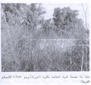
Most agriculture in Barqa remained rain-fed, but villagers dug several wells to irrigate citrus groves and other orchards.
Khalidi securely documents the presence of several irrigation wells. Later local Palestinian research preserves the names and locations of individual orchard wells, which is valuable community documentation but should not be treated as a complete official water register.
Education
Barqa did not have an operating formal school before the Nakba. Children attended school in neighboring al-Batani al-Gharbi.
Palestinian community documentation also records elementary instruction by local religious teachers in Barqa itself.
Around 1945, villagers reportedly began collecting funds and constructing a school of their own. The building process was incomplete, however, and the school did not officially open before the events of the Nakba.
The Mosque and Shrines
Barqa had a mosque, around which stood several tombs and shrines associated with local religious traditions.
Khalidi records that villagers identified them as the tombs of Shaykh Muhammad, Shaykh Zarruq, and al-Nabi Barq.
Later Palestinian community documentation provides additional descriptions of these shrines and local practices associated with them. Their attribution to particular religious figures should be understood as community tradition rather than as conclusive archaeological identification.
Archaeological Remains
Khalidi considers it possible that Barqa occupied the site of Barka, known as Bareca in the Roman period.
Recorded remains included an ancient well, carved stones or inscriptions, and pottery fragments, all indicating earlier occupation of the site.
These remains do not by themselves demonstrate uninterrupted settlement from antiquity to the modern Palestinian village, and the identification is therefore retained as a historical probability.
Barqa before Its Occupation in 1948
Barqa lay in the northern part of the Gaza subdistrict, within the zone targeted by Haganah offensives south and west of Ramla during May 1948.
As the British Mandate approached its end, Operation Barak was launched to expand Haganah control southward and westward and to remove Palestinian communities from the targeted area.
Operation Barak
PalQuest dates Operation Barak from 9 to 13 May 1948. The Haganah's Giv'ati Brigade was its principal force, with the Palmach's Negev Brigade participating at the broader operational level.
The operational objectives, as summarized by PalQuest from contemporary orders and later historical accounts, included expanding the area under Haganah control, undermining Palestinian communities, and driving a substantial part of the population from the occupied area.
For Barqa specifically, Khalidi links the village to a Giv'ati attack conducted between 10 and 13 May.
Occupation and Depopulation of Barqa
Palestine Remembered lists 13 May 1948 as the village's occupation date.
Khalidi's detailed account is more precise in another sense: it states that Barqa's inhabitants evacuated the village when the Giv'ati Brigade began its assault sometime between 10 and 13 May 1948 as the brigade expanded southward and westward during Operation Barak.
The village-specific account does not establish the exact day on which the last civilians left or the exact hour at which military control over the entire site was completed. This article therefore treats 10–13 May 1948 as the documented attack and depopulation window, while retaining 13 May as the summary date given by Palestine Remembered.
The villagers' departure was directly connected to the military assault, but the principal source does not provide a detailed account of every stage of civilian flight or expulsion.
Military Unit
The village-specific attacking formation was the Haganah's Giv'ati Brigade.
The Negev Brigade also participated in Operation Barak as a whole, but the Barqa entry specifically identifies Giv'ati as the force attacking the village. The direct capture of Barqa should therefore not be assigned to the Negev Brigade without additional village-specific evidence.
PalQuest lists Egyptian and Sudanese forces among the Arab formations relevant to the wider operation, but the Barqa-specific sources do not establish a particular Egyptian or Sudanese garrison defending the village itself.
Occupation Chronology
- 9 May 1948
Beginning of Operation Barak
The offensive began, principally under the Giv'ati Brigade, to expand Haganah control south and west of Ramla before the end of the Mandate.
- Between 10 and 13 May 1948
Attack on Barqa
Khalidi states that the villagers left as the Giv'ati Brigade began its attack during this period.
- During the 10–13 May assault
Depopulation
The departure was directly associated with the military attack; the source does not establish a separate exact date for the departure of the last family.
- 13 May 1948
Palestine Remembered summary date
The date appears as the occupation date in the site's statistical header and corresponds to the end of Khalidi's attack window.
- 13 May 1948
End of the formally dated first phase of Operation Barak
PalQuest gives this date as the end of the operation's formally listed 9–13 May period.
- Later; exact date not established by the core source
Destruction of most of the village
Most village buildings were subsequently destroyed, although at least two houses survived into the period of Khalidi's field survey.
Refugees from Barqa
Palestine Remembered estimates Barqa's population in 1948 at approximately 1,032. This is a later demographic estimate rather than an official Mandate census figure.
The same source estimates that refugees from Barqa and their descendants numbered approximately 6,340 in 1998. A Palestinian community study gives the closely related figure of 6,346. Neither should be treated as an official comprehensive refugee census.
Israeli Settlements on or near Barqa Village Lands
Walid Khalidi and PalQuest state that no Israeli settlement was established on Barqa's village lands.
| Settlement | Established | Relationship to Barqa |
|---|---|---|
| Gan Yavne | 1931 | Located close to the Barqa site to the north, but not classified by Khalidi as established on Barqa village land |
| Shetulim | 1950 | Located near Barqa but established on land belonging to Isdud according to Khalidi |
A later Palestinian local study differs and associates Gan Yavne and Bitzaron with lands historically connected to Barqa. This classification does not match Khalidi/PalQuest or the 1945 cadastral statistical picture, which records only 226 dunums in the Jewish ownership category within Barqa's land unit.
Gan Yavne and Bitzaron are therefore not classified here as settlements definitively established on Barqa's village lands without further verification from original cadastral maps and records concerning any earlier separation of purchased land from the Barqa statistical unit.
Barqa Today
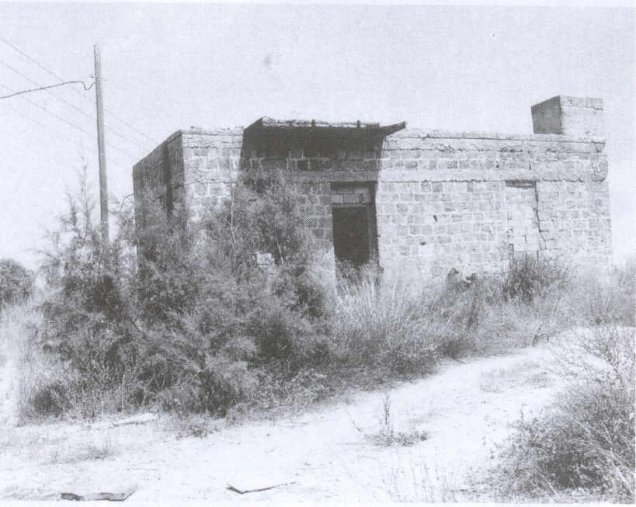
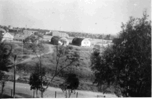
In Walid Khalidi's field description, two village houses remained standing.
One was a concrete building with a roofed portico on two sides and was being used as a warehouse. The other was a deserted stone house with rectangular doors and windows and a flat roof, standing amid wild vegetation.
Weeds covered the site, interspersed with cactuses, eucalyptus, and palm trees, while the surrounding lands were cultivated.
This description does not constitute direct field verification of conditions in 2026. It derives from field research undertaken for All That Remains before the book's publication in 1992.
Palestine Remembered and village-community sources also preserve later photographs, documents, and oral histories concerning Barqa. These are valuable for preserving the memory of the village but do not by themselves constitute an independent comprehensive contemporary survey of all former village lands.
Sources
- PalQuestPalQuest – Barqa
- PalQuestPalQuest – Operation Barak
- Palestine RememberedPalestine Remembered – Barqa, Gaza District
- Palestine RememberedPalestine Remembered – Barqa entry from Walid Khalidi's All That Remains
- Institute for Palestine StudiesInstitute for Palestine Studies – Walid Khalidi, All That Remains
- users.cecs.anu.edu.auGovernment of Palestine – Census of Palestine 1922
- users.cecs.anu.edu.auGovernment of Palestine – Census of Palestine 1931
- sabil.meVillage Statistics 1945 – Gaza Sub-District population and land ownership
- palqura.comPalestinian Villages Encyclopedia – Barqa; supplementary local documentation on boundaries, education, water, and community life
- PalQuestPalQuest – All That Remains: Methodology and Field Research
Photo gallery


Photos from the village's people
Photos sent in by visitors and published after review.
Add a photo of this village
Log in to add photos of this village.
Other villages from Gaza
More from the archive


 Download Our Palestine App
The whole archive in the palm of your hand: depopulated villages, the Nakba, the massacres and Al-Aqsa — free, with no ads to erase the story.
Download Our Palestine App
The whole archive in the palm of your hand: depopulated villages, the Nakba, the massacres and Al-Aqsa — free, with no ads to erase the story.



Comments
No comments yet — be the first to write one.
Add your comment
Name and email are optional. Comments appear after review.