
The depopulated village of Julis / District of Gaza
About the depopulated village of Julis
- District
- Gaza
- Date Julis was occupied
- 11 June 1948
- Population in 1948
- 1,195
- Military operation
- Operation Barak
- Brigade that carried it out
- Givati Brigade
- Who defended the village
- Egyptian Army
- Distance from the governorate centre
- 26.5 (km) North East of Gaza
- Elevation above sea level
- 50 m
- Cause of displacement
- Military assault by Zionist troops
- Extent of destruction
- The village was mostly destroyed with the exception of few houses remain.
- Ethnic cleansing
- Julis inhabitants were completely ethnically cleansed.
- Settlements built on the built-up area of Julis after 1948
- Hodaya
Hover a dot to read the village name, or click to open its card.
Borders of the depopulated village of Julis
Julis: A Depopulated Palestinian Village in the Gaza District
Julis was a Palestinian village in the Gaza District, located approximately 26.5 km northeast of Gaza city on slightly elevated ground in the southern coastal plain, at an average elevation of about 50 metres above sea level. Its inhabitants were displaced during the Nakba and the occupation of Palestine in 1948. The village itself was most probably occupied by the Giv'ati Brigade on 10–11 June 1948.
Location of Julis
Julis stood on slightly elevated terrain in the southern coastal plain, along the edge of a wadi. The village was built over an archaeological site whose ancient name remains unidentified.
It was approximately 26.5 km northeast of Gaza city and had an average elevation of about 50 metres above sea level.
Nearby Palestinian villages and towns included Bayt Daras, Ibdis, Hamama, al-Majdal, Kawkaba, and Iraq Suwaydan.
Name and History of Julis
Walid Khalidi and PalQuest do not provide a documented explanation for the origin of the name Julis. The principal reference states only that the village stood on an ancient archaeological site whose earlier name is unknown.
Later local accounts sometimes connect the name Julis with “Julius,” but the approved principal sources used here do not provide sufficient evidence to establish this explanation as historical fact.
In 1596, Julis was a village in the nahiya of Gaza within the liwa of Gaza, with an estimated population of approximately 204. It paid taxes on wheat, barley, fruit, goats, beehives, vineyards, and other forms of agricultural production.
In the late nineteenth century, Julis was described as having adobe houses, a well to its south, and a pool and orchards to the northeast.
Architecture and Transportation in Julis
Julis acquired particular importance as a transportation centre during the Second World War, when the British Mandate authorities constructed a highway through the village running roughly parallel to the main coastal road before joining it.
At Julis, this road intersected the route from al-Majdal toward the Jerusalem–Jaffa highway. The British also established a military camp near this important junction.
The village had an approximately square layout bounded by two major roads, with a traffic circle at one edge where the roads intersected. Houses stood close together and were constructed of both adobe and cement.
Village shops were distributed along the main roads.
The Mosque and Shaykh Khayr Shrine
The inhabitants of Julis were Muslim, and the village had a mosque.
Julis also contained a shrine dedicated to Shaykh Khayr, a figure in local historical tradition. Villagers believed that he had been killed while fighting the Crusaders. This is recorded as a local tradition rather than as an independently verified archaeological conclusion.
Education in Julis
A boys' school was established in Julis in 1937. By the mid-1940s, it enrolled approximately 86 pupils.
Economic Life in Julis
Agriculture was the principal source of livelihood. Groundwater was abundant in the Julis area and was used for domestic needs as well as irrigation.
The villagers cultivated cereals, vegetables, and fruit. Fruit orchards were concentrated particularly on the eastern and northern sides of the village. Agriculture relied on both rainfall and irrigation.
According to the 1944/45 statistics, 1,360 dunums were devoted to citrus and bananas, 10,803 dunums to cereals, and 931 dunums were irrigated or used for plantations.
Land Ownership in Julis
The total land area of Julis was 13,584 dunums according to the 1944/45 statistics.
Land ownership in Julis, 1944/45
- Arab13,225 dunums97%
- Jewish0 dunums0%
- Public359 dunums3%
Palestine Remembered presents the corresponding categories in its Arabic table as 13,225 Palestinian dunums, zero dunums “transferred to Zionists,” and 359 dunums of communal land.
Land Use in Julis, 1944/45
Land use in Julis
- Arab
- Public
- Citrus and bananas1,360 dunums
- Plantations and irrigable land931 dunums
- Cereals10,803 dunums
- Built-up area30 dunums
- Non-cultivable land460 dunums
A total of 13,094 dunums was classified as cultivated or cultivable, all of it Arab land in the PalQuest statistics. Built-up and non-cultivable land together amounted to 490 dunums.
Population of Julis
Population of Julis in selected years
- 1596204Estimate derived from Ottoman records
- 1922481Official British Mandate census
- 1931682Official British Mandate census
- 1944/451,030Official statistics
- 19481,195Later estimate published by Palestine Remembered
- Estimated refugees in 19987,337Later estimate published by Palestine Remembered
Number of Houses in Julis
Number of houses in Julis
- 1931165Official census figure
- 1948289Later estimate published by Palestine Remembered
Archaeological Sites in Julis
Julis stood on an ancient archaeological site. Evidence of earlier settlement included an inscribed door lintel, an old olive press, and stone-lined cisterns.
Three additional archaeological sites lay nearby:
- Rasm al-Farsh.
- Shaykh Khayr.
- Khirbat al-Biyar.
Occupation of the Military Barracks at Julis
The military takeover of the Julis area began before the village itself was fully occupied. During the night of 27–28 May 1948, the First Battalion of the Giv'ati Brigade occupied the British military barracks at Julis.
The attack took place in the context of the later phase of Operation Barak, but the seizure of the barracks did not amount to complete control of Julis village. The attacking forces failed at that stage to occupy the entire village.
The account reproduced by Khalidi records that Egyptian forces subsequently attempted to recover the position.
Occupation and Depopulation of Julis during the Nakba
Approximately two weeks after the military barracks had been seized, the Third Battalion of the Giv'ati Brigade conducted a series of attacks against individual villages around the time the first truce was taking effect.
According to Walid Khalidi and PalQuest, Julis itself fell to Israeli occupation forces on 10–11 June 1948. Palestine Remembered specifies 11 June as the occupation date.
Palestine Remembered categorizes the occupation of Julis under Operation Barak and identifies the Third Battalion of the Giv'ati Brigade as the attacking unit. PalQuest's detailed village narrative directly associates the seizure of the barracks on 27–28 May with Operation Barak and then places the occupation of the village itself approximately two weeks later during operations by Giv'ati's Third Battalion.
The seizure of the military barracks and the final occupation of the village should therefore be treated as two distinct stages.
- Occupation of the military barracks: night of 27–28 May 1948.
- Unit that captured the barracks: First Battalion, Giv'ati Brigade.
- Final occupation of the village: 10–11 June 1948.
- Palestine Remembered date: 11 June 1948.
- Unit that occupied the village: Third Battalion, Giv'ati Brigade.
- Operational context: Operation Barak and the subsequent Giv'ati operations around the beginning of the first truce.
- Arab military force: Palestine Remembered identifies the Egyptian Army as the defending force, while the sources also document Egyptian attempts to recover Julis.
- Fate of the inhabitants: the Palestinian population of Julis was displaced as a result of the military assault and occupation during the Nakba.
Some details concerning these operations derive from Israeli accounts quoted by Khalidi. Such sources are not used independently here and are mentioned only because they are reproduced in the approved Palestinian reference.
The Battle of Julis in July 1948
After its occupation, Julis remained an important military position because of its barracks and location on a major road junction.
At the end of the first truce in July 1948, the Egyptian Army's Sixth Battalion was ordered to attempt to recapture Julis. Gamal Abdel Nasser served as a staff officer in this battalion; he was not the overall commander of the Egyptian forces.
In his memoirs, Abdel Nasser criticized the planning of the operation and described the shortage of intelligence concerning the fortified position held by Israeli occupation forces at Julis.
The Egyptian attempt to recover Julis failed. The sources record a major engagement on 10 July 1948 in which the Egyptian force suffered significant casualties. Ismail Muhyi al-Din, one of Abdel Nasser's close colleagues, was among those killed.
Settlement Established on the Lands of Julis
According to Walid Khalidi and PalQuest, one settlement was established on the lands of Julis after the Nakba:
- Hodiyya: established in 1949 southwest of the village site.
Julis Today
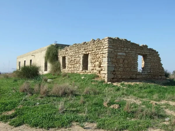
According to the field description published by Walid Khalidi in All That Remains, several houses survived the destruction of the village. Most were built of cement and had simple architectural features, including flat roofs and rectangular doors and windows. One surviving house had two storeys, while another contained an upper room.
The source records that one house in the southwestern part of the site was being used as a residence. Cactus, sycamore, and palm trees grew at the site, while citrus trees had been planted in part of it.
Khalidi also recorded that the former British military camp was being used by the Israeli army and that the surrounding village lands were being cultivated.
Palestine Remembered contains later photographs and audiovisual contributions concerning Julis, including material associated with a visit to the site in 2019. The website itself cautions that contributed material does not necessarily constitute independently verified field documentation.
The principal description above therefore derives from field research published in Khalidi's book in 1992. The approved sources used here do not provide a sufficiently comprehensive and independent contemporary field survey to verify the precise condition of every part of the Julis site in 2026.
Sources
- PalQuestPalQuest – Interactive Encyclopedia of the Palestine Question: Julis
- PalQuestPalQuest – Operation Barak
- Palestine RememberedPalestine Remembered – Julis, Gaza District
- Palestine RememberedPalestine Remembered – Julis entry from All That Remains
- Institute for Palestine StudiesInstitute for Palestine Studies – All That Remains, Walid Khalidi
Photo gallery


Photos from the village's people
Photos sent in by visitors and published after review.
Add a photo of this village
Log in to add photos of this village.
Other villages from Gaza

More from the archive

 Download Our Palestine App
The whole archive in the palm of your hand: depopulated villages, the Nakba, the massacres and Al-Aqsa — free, with no ads to erase the story.
Download Our Palestine App
The whole archive in the palm of your hand: depopulated villages, the Nakba, the massacres and Al-Aqsa — free, with no ads to erase the story.



Comments
No comments yet — be the first to write one.
Add your comment
Name and email are optional. Comments appear after review.