
The depopulated village of Isdud / District of Gaza
About the depopulated village of Isdud
- District
- Gaza
- Date Isdud was occupied
- 28 October 1948
- Population in 1948
- 5,359
- Military operation
- Operation Yoav
- Brigade that carried it out
- The available sources do not identify the unit that entered Isdud
- Who defended the village
- Egyptian Army
- Distance from the governorate centre
- 35 km northeast of Gaza
- Elevation above sea level
- 25 m
- Cause of displacement
- Military attacks and bombardment by Israeli occupation forces: thousands of the area's inhabitants fled during the attack of 2–3 June 1948, most of those remaining fled with the retreating Egyptian forces in October, and those who stayed in the town (some 300) were expelled southwards
- Extent of destruction
- The village was mostly destroyed with the exception of its two schools, its crumbling mosque, and one of its shrines.
- Ethnic cleansing
- Isdud inhabitants were completely ethnically cleansed.
- Settlements built on the built-up area of Isdud after 1948
- Bene Darom (1949), Sde 'Uzziyyahu and Shetulim (1950), and Gan ha-Darom (1953)
Hover a dot to read the village name, or click to open its card.
Borders of the depopulated village of Isdud
Isdud: A Depopulated Palestinian Village in the Gaza District
Isdud was a depopulated Palestinian village in the Gaza District, located approximately 35 kilometers northeast of Gaza and about 5 kilometers from the Mediterranean coast. The village stood on a sandy hill overlooking extensive areas to the east, north, and south, on a site associated with an almost continuous history of settlement stretching back to antiquity.
- Subdistrict
- Gaza
- Distance from district center
- 35 km northeast of Gaza
- Average Elevation
- 25 m above sea level
- Population in 1931
- 3,140
- Number of Houses in 1931
- 764
- Population in 1944/1945
- 4,620 – Arab population; the same statistical unit also recorded 290 Jews (total 4,910)
- Estimated Population in 1948
- About 5,359 – a later demographic estimate, not an official census
- Total Land Area in 1945
- 47,871 dunams
- Attack and Depopulation
- After Egyptian forces took up positions in Isdud in May 1948, Israeli occupation forces launched a three-pronged attack on 2–3 June that led to the flight of thousands among the local population, another attack on 9–10 June, and then naval and aerial attacks at the beginning of Operation Yoav in October. Most of the remaining inhabitants fled with the retreating Egyptian columns before Israeli occupation forces entered the town on 28 October 1948, and some 300 who stayed behind, putting up white flags, were almost immediately expelled southwards, according to Morris as cited by Khalidi.
- Final Israeli Control
- 28 October 1948, in the last stage of Operation Yoav
- Military Operation
- Operation Yoav (final occupation); earlier, Israeli occupation forces briefly cut off the road between al-Majdal and Isdud during Operation Barak, and PalQuest lists Isdud among the villages affected by both operations
- Military Unit
- The available sources do not identify the unit that entered Isdud
- Cause of Depopulation
- Military attacks and bombardment by Israeli occupation forces: thousands of the area's inhabitants fled during the attack of 2–3 June 1948, most of those remaining fled with the retreating Egyptian forces in October, and those who stayed in the town (some 300) were expelled southwards
- Settlements Documented on Village Lands
- Bene Darom (1949), Sde 'Uzziyyahu and Shetulim (1950), and Gan ha-Darom (1953)
The Government of Palestine's 1944/1945 statistics recorded 4,620 Arabs and 290 Jews within the Isdud statistical unit, for a total of 4,910 inhabitants. During the Nakba and the occupation of Palestine in 1948, Isdud became an important Egyptian military position and endured repeated Israeli attacks before its final occupation on 28 October 1948 during the last stage of Operation Yoav.
Location of Isdud
- Isdud was located approximately 35 kilometers northeast of Gaza.
- It lay about 5 kilometers from the Mediterranean coast.
- The village stood on a sandy hill overlooking broad areas to the east, north, and south.
- The coastal highway and railway passed near the village, which had its own station on the coastal railway.
- Its lands bordered those of 'Arab Suqrir, Barqa, al-Batani al-Gharbi, Bayt Daras, Hamama, and Julis.
Isdud Through History
The name Isdud derived from the ancient city of Ashdod, whose site was inhabited from at least the seventeenth century BCE. Archaeological excavations indicate an almost continuous history of settlement at the site until 1948.
During the Roman period, the city was known as Azotus. Following the Muslim conquest in the seventh century CE, the geographer Ibn Khurdadhbih referred to it as Azdud and described it as a postal station on the route between Ramla and Gaza.
In 1596, Isdud was a village in the nahiya of Gaza within the liwa' of Gaza and had an estimated population of approximately 413.
The Built Environment of Isdud
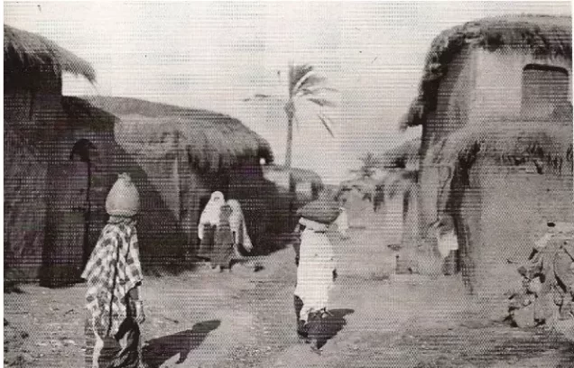
In the late nineteenth century, Isdud extended along the eastern curve of a low hill covered with orchards. A ruined khan stood southeast of the village.
Most houses were single-story adobe structures. A traditional house included a courtyard enclosed by adobe walls.
The two principal water sources were a masonry well and a pond surrounded by date-palm and fig groves. Other wells, ranging from approximately 15 to 35 meters in depth, were used to irrigate crops.
The built-up area covered approximately 131 dunums in the 1944/1945 statistics.
Population of Isdud
The 1922 census recorded 2,566 inhabitants in Isdud, rising to 3,140 in the 1931 census.
The Government of Palestine's 1944/1945 statistics recorded 4,910 inhabitants in the Isdud statistical unit, consisting of 4,620 Arabs and 290 Jews. The Palestinian Arab population of the village was predominantly Muslim.
The figures of 5,359 inhabitants for 1948 and 32,911 refugees for 1998 published by Palestine Remembered are later estimates rather than official Government of Palestine censuses.
Population of Isdud
- 1596413Historical estimate based on Ottoman records
- 19222,566Official census under the British Mandate
- 19313,140Official census under the British Mandate
- 1944/19454,910Government of Palestine statistics: 4,620 Arabs and 290 Jews
- 19485,359Later estimate published by Palestine Remembered
- 199832,911Later refugee-population estimate published by Palestine Remembered
Number of Houses in Isdud
The 1931 census recorded 764 houses in Isdud. The figure of 1,303 houses for 1948 published by Palestine Remembered is a later estimate rather than an official Government of Palestine census figure.
Number of Houses in Isdud
- 1931764Official census
- 19481,303Estimate published by Palestine Remembered
Education and Public Facilities in Isdud
Isdud had two elementary schools. The boys' school opened in 1922 and had approximately 371 pupils by the mid-1940s.
The girls' school was established in 1942 and had approximately 74 pupils by the mid-1940s.
Isdud also had a local or municipal council responsible for a range of public affairs.
Mosques and Shrines in Isdud
Isdud had two mosques and three shrines associated with religious and historical figures.
One shrine was locally believed to belong to Salman al-Farisi, a companion of the Prophet Muhammad, and stood within a mosque built during the reign of the Mamluk sultan al-Zahir Baybars. Walid Khalidi notes that the attribution of the shrine to Salman al-Farisi was a mistaken local belief.
A second shrine was associated with Shaykh al-Matbuli, an Egyptian religious figure, while the third was dedicated to Ahmad Abu al-Iqbal.
Land Ownership in Isdud
The total land area recorded for Isdud in the 1944/1945 statistics was 47,871 dunums.
The Arabic Palestine Remembered table uses the categories “Palestinian,” “Transferred to Zionists,” and “Masha'.” These terms are preserved below to reflect the terminology used by that source. The official Government of Palestine statistics use the categories “Arab,” “Jewish,” and “Public.”
Land Ownership in Isdud, 1944/1945, Using the Terminology of Palestine Remembered
- Palestinian32,905 dunums69%
- Transferred to Zionists2,487 dunums5%
- Masha' (source terminology)12,479 dunums26%
Land Use in Isdud in 1944/1945
A total of 35,366 dunums was cultivated or classified as cultivable, consisting of 32,413 dunums of Arab land, 2,487 dunums of Jewish land, and 466 dunums of public land.
Cereals covered 23,762 dunums, citrus and bananas covered 3,277 dunums, and plantations and irrigable land covered another 8,327 dunums.
Land Use in Isdud According to the 1944/1945 Statistics
- Arab
- Jewish
- Public
- Citrus and Bananas3,277 dunums
- Plantations and Irrigable Land8,327 dunums
- Cereals23,762 dunums
- Built-up Area131 dunums
- Non-Cultivable Land12,374 dunums
Economic Life in Isdud
Agriculture formed the backbone of Isdud's economy. The principal crops included cereals, particularly wheat, as well as citrus fruit, grapes, figs, other fruits, and vegetables.
Farmers relied on rainfall as well as wells, some between approximately 15 and 35 meters deep, to irrigate orchards and other irrigated crops.
Commerce was also important. Isdud contained a number of shops and held a weekly market every Wednesday that attracted residents of neighboring villages.
The Isdud railway station on the coastal railway helped facilitate the movement of people, agricultural produce, and other goods.
Archaeological Sites in Isdud
Isdud and its surrounding lands were rich in archaeological remains. At least nine khirbas contained pottery fragments, mosaic floors, cisterns, an ancient olive press, and other remains.
Archaeological excavations at the main site indicate almost continuous settlement from the seventeenth century BCE until 1948. The fourteenth and thirteenth centuries BCE appear to have been among the site's most prosperous periods in antiquity.
Isdud and the Egyptian Army in May 1948
When Egyptian forces entered Palestine on 15 May 1948, Isdud was one of their early objectives. The Egyptian Ninth Battalion was initially assigned to take up positions there.
According to Gamal Abdel Nasser, who was then serving as a staff officer in the Egyptian army, another battalion arrived at the front on 22 May and Isdud was handed over to the Sixth Battalion.
Isdud consequently became an important forward position on the front line between Egyptian and Israeli forces and marked the principal northern limit of the Egyptian advance along the Palestinian coast.
Operation Barak and the Early Fighting Around Isdud
PalQuest lists Isdud among the villages affected by Operation Barak, an offensive carried out mainly by the Giv'ati Brigade, with the participation of the Negev Brigade, in the southern coastal plain during May 1948.
The PalQuest page for Operation Barak dates its principal phase to 9–13 May, before Egyptian forces entered Palestine on 15 May. The Isdud village entry nevertheless associates the later temporary cutting of the al-Majdal–Isdud road, after the Egyptian deployment, with Operation Barak.
Because of this chronological inconsistency within the source, Operation Barak is best treated as part of the background to Israeli offensives in the sector, while the subsequent fighting around Egyptian-held Isdud should be described separately.
The Attacks of 2–3 and 9–10 June 1948
On 2–3 June 1948, Israeli forces launched a three-pronged attack in the Isdud area in an effort to strike Egyptian positions and induce the Palestinian population of the surrounding area to leave.
Walid Khalidi, citing Benny Morris, records that the attack caused thousands of local inhabitants to flee. The New York Times reported that some of the heaviest fighting on the southern front on 3 June took place around Isdud.
The attack did not result in the occupation of Isdud. Another Israeli assault followed on 9–10 June, immediately before the First Truce took effect on 11 June.
Egyptian forces remained stationed in Isdud throughout the First Truce, and Gamal Abdel Nasser was based there during this period.
Fighting Between the Truces
Isdud remained a front-line position after the First Truce. Israeli commando units conducted raids in the vicinity of Egyptian positions.
In July 1948, contemporary press reports referred to an Israeli unit known as “Samson's Foxes” reaching Egyptian positions in the Isdud area, but the town itself remained outside Israeli control.
Operation Yoav
Operation Yoav began on 15 October 1948 and continued until 4 November. Its objective was to break the Egyptian lines in southern Palestine and connect Israeli forces in the Negev with those positioned farther north.
The Giv'ati, Negev, and Yiftach Brigades were assembled for the operation, while the Har'el Brigade participated in the connected operational area. Egyptian forces still controlled the coastal strip as far north as Isdud.
The offensive opened with extensive aerial and artillery attacks, and Isdud came under both naval and aerial bombardment during the early stages of the operation.
PalQuest records that the later stages of Operation Yoav became geographically coordinated with Operation ha-Har in the Hebron hills. The operation directly associated with the final capture of Isdud itself, however, was Operation Yoav.
The Occupation of Isdud on 28 October 1948
Isdud was not finally occupied until late October 1948, during the last stage of Operation Yoav.
By 18 October, Israeli aircraft had carried out successive bombing raids against targets that included Isdud. As Israeli forces advanced and the danger of encirclement increased, Egyptian forces withdrew southward along the coastal road.
Most of the Palestinian civilians who remained in Isdud left with the retreating Egyptian columns before Israeli forces entered the town on 28 October.
Walid Khalidi and PalQuest, citing Benny Morris, record that approximately 300 townspeople remained and raised white flags before being expelled southward shortly afterward. This information is presented through the Palestinian intermediary source Khalidi/PalQuest rather than through independent reliance on the Israeli source.
Palestine Remembered and the Palestinian Villages Encyclopedia identify the Giv'ati Brigade as the force that entered Isdud. PalQuest lists Giv'ati among the brigades participating in Operation Yoav but does not explicitly attribute the final entry into Isdud to a single brigade in its village entry.
The Displacement of Isdud's Inhabitants During the Nakba
The displacement of Isdud's Palestinian population occurred in stages. The June attacks caused part of the population to leave, while others remained in the town under Egyptian military protection through the two truces.
When Egyptian forces withdrew southward in late October, most of the remaining inhabitants left with them. Those who stayed behind were expelled after the Israeli entry.
Most displaced people from Isdud went toward the Gaza Strip, where families from the village later lived in Gaza City, refugee camps, and other areas of the Strip.
Occupation and Depopulation Chronology
- Probably late May 1948
Cutting of the al-Majdal–Isdud road
After Egyptian forces took up positions in Isdud (it was handed over to the Sixth Battalion on 22 May, according to Gamal Abdel Nasser), the town lay on the front line, and Israeli occupation forces briefly cut off the road between al-Majdal and Isdud during Operation Barak before the Egyptians dislodged them and restored their supply lines, according to Khalidi.
- 2–3 June 1948
Ground assault and beginning of the exodus
Israeli operational orders called for an attack on al-Majdal, Isdud or Yibna to 'cause the wandering [i.e., exodus] of the smaller settlements in the area', and a three-pronged attack was launched that led to the flight of thousands among the local population, according to Morris as cited by Khalidi. The New York Times reported that the 'bloodiest fighting' in the south of the country on 3 June was taking place around Isdud.
- 9–10 June 1948
Second attack
Israeli occupation forces launched another attack, and the following day the first truce took effect. The town remained in Egyptian hands, and Gamal Abdel Nasser was stationed there throughout the truce.
- July 1948
Raids between the truces
In the period between the two truces, commando units of the Israeli occupation forces carried out raids in the vicinity of Isdud, and a New York Times story on 16 July indicated that a unit named 'Samson's Foxes' had reached Egyptian positions at Isdud.
- From 15 October 1948
Shelling of the village
Isdud came under naval and aerial attack at the beginning of Operation Yoav, which began on 15 October, and the New York Times stated on 18 October that Israeli air force bombers had flown 'practically unhindered' to their targets for three nights in succession and that these targets included Isdud.
- Late October 1948 (before 28 October)
Egyptian withdrawal and flight of most of the inhabitants
In danger of being encircled and isolated, the Egyptian forces withdrew southwards along the coastal road, and the bulk of the remaining civilian population fled with the retreating Egyptian columns before Israeli occupation forces entered.
- 28 October 1948
Final occupation
Israeli occupation forces entered Isdud in the last stage of Operation Yoav. An Israeli army communiqué issued on the date of occupation claimed that the forces had entered the town at the request of a delegation from its Arab population, according to Khalidi.
- Shortly after 28 October 1948
Expulsion of the remaining inhabitants
Some 300 townspeople remained, putting up white flags, and 'they were almost immediately expelled southwards', according to Morris as cited by Khalidi.
- 1949
Settlement on village lands
The settlement of Bene Darom was founded on village lands, at a good distance to the north of the village site.
- 1950
Settlement on village lands
The settlements of Sde 'Uzziyyahu and Shetulim were established on village lands, east of the village site.
- 1953
Settlement on village lands
The settlement of Gan ha-Darom was founded on village lands, at a good distance to the north of the village site.
Settlements Established on the Lands of Isdud
Walid Khalidi and PalQuest identify four settlements established on the lands of Isdud after the Nakba:
- Bene Darom: established in 1949 on Isdud land, north of the village site.
- Sde 'Uzziyyahu: established in 1950 east of the village site on Isdud land.
- Shetulim: established in 1950 east of the village site on Isdud land.
- Gan ha-Darom: established in 1953 on Isdud land north of the village site.
The Site of Isdud After the Nakba
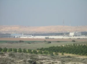
According to Walid Khalidi's field description, most of Isdud's houses were destroyed and the rubble became covered with grass and thorny vegetation.
A large ruined mosque remained standing just south of the center of the site, with its crumbling pillars, arched entrances, and windows still visible.
Approximately 200 meters southwest of the site, the two former school buildings remained abandoned, with a neglected shrine nearby to their south.
The village's main street could still be traced running north to south, and a large unused building remained on its eastern side. Palm, doum palm, and cypress trees were scattered around the site.
Khalidi also recorded an avocado grove along the northern edge of the site and cultivated fields along its southern edge.
This description is based on fieldwork conducted for Walid Khalidi's All That Remains and should not necessarily be treated as a field survey updated to the present day.
Sources
- PalQuestPalQuest – Interactive Encyclopedia of the Palestine Question: Isdud
- PalQuestPalQuest – Interactive Encyclopedia of the Palestine Question: Operation Yoav
- PalQuestPalQuest – Interactive Encyclopedia of the Palestine Question: Operation Barak
- Institute for Palestine StudiesInstitute for Palestine Studies: Walid Khalidi, All That Remains
- Palestine RememberedPalestine Remembered: Isdud – Gaza District
- palqura.comPalestinian Villages Encyclopedia: The Occupation of Isdud
Photo gallery


Photos from the village's people
Photos sent in by visitors and published after review.
Add a photo of this village
Log in to add photos of this village.
Other villages from Gaza

More from the archive

 Download Our Palestine App
The whole archive in the palm of your hand: depopulated villages, the Nakba, the massacres and Al-Aqsa — free, with no ads to erase the story.
Download Our Palestine App
The whole archive in the palm of your hand: depopulated villages, the Nakba, the massacres and Al-Aqsa — free, with no ads to erase the story.



Comments
No comments yet — be the first to write one.
Add your comment
Name and email are optional. Comments appear after review.