
The depopulated village of Kawkaba / District of Gaza

Kawkaba
About the depopulated village of Kawkaba
- District
- Gaza
- Date Kawkaba was occupied
- 19 October 1948
- Population in 1948
- 789
- Military operation
- Operation Yoav
- Brigade that carried it out
- The available sources do not identify the unit that occupied the village
- Distance from the governorate centre
- 25 km northeast of Gaza
- Elevation above sea level
- 100 m
- Cause of displacement
- Fear after the destruction of neighbouring Burayr in Operation Barak (13 May 1948), then expulsion by Israeli occupation forces at the first occupation on 14 June 1948, according to an Egyptian account; others left during Operation Yoav in October 1948
- Extent of destruction
- The village has been completely defaced
- Ethnic cleansing
- Kawkaba inhabitants were completely ethnically cleansed.
- Settlements built on the built-up area of Kawkaba after 1948
- Kokhav Mikha'el, founded in 1950 on village lands southeast of the village site
Hover a dot to read the village name, or click to open its card.
Borders of the depopulated village of Kawkaba
Kawkaba – A Depopulated Palestinian Village in the Gaza Subdistrict
Kawkaba was a Palestinian village in the Gaza Subdistrict, located approximately 25 km northeast of Gaza city and about 100 metres above sea level. Its inhabitants were displaced in stages during the Nakba and the occupation of Palestine in 1948, and the village came under final Israeli control in October 1948.
- Subdistrict
- Gaza
- Distance from district center
- 25 km northeast of Gaza
- Average Elevation
- 100 m above sea level
- Population in 1931
- 522
- Number of Houses in 1931
- 121
- Population in 1944/1945
- 680
- Estimated Population in 1948
- About 789 – a later demographic estimate, not an official census
- Total Land Area in 1945
- 8,542 dunams
- Attack and Depopulation
- The villagers fled westwards to Gaza on 13 May 1948 after the destruction of neighbouring Burayr in Operation Barak, although some seem to have remained; the village was then first occupied either in 9–14 May 1948, according to PalQuest's chronology, or on 14 June 1948, according to an Egyptian account which says that its inhabitants were expelled at that time, and Egyptian forces recaptured it on 8 July. It finally fell to Israeli occupation forces during Operation Yoav, the Israeli army announcing its capture on 20 October 1948; the village thus changed hands at least three times, and its inhabitants were probably displaced in stages.
- Final Israeli Control
- Probably 19–20 October 1948, during Operation Yoav: the village apparently remained in Arab hands until 18–19 October, and on 20 October the Israeli army announced its capture, according to the New York Times as cited by Khalidi; the available sources do not give the exact day of its occupation
- Military Operation
- Operation Yoav (final occupation); PalQuest also lists the village among those affected by Operation Barak (9–13 May 1948)
- Military Unit
- The available sources do not identify the unit that occupied the village at any of its stages; Operation Barak was carried out by the Givati Brigade and the Negev Brigade, and Operation Yoav by the Givati, Yiftach, Negev and Harel Brigades
- Cause of Depopulation
- Fear after the destruction of neighbouring Burayr in Operation Barak (13 May 1948), then expulsion by Israeli occupation forces at the first occupation on 14 June 1948, according to an Egyptian account; others left during Operation Yoav in October 1948
- Settlements Documented on Village Lands
- Kokhav Mikha'el, founded in 1950 on village lands southeast of the village site
Location of Kawkaba
- Subdistrict: Gaza.
- Location: approximately 25 km northeast of Gaza city.
- Elevation: approximately 100 metres above sea level.
Kawkaba stood on uneven ground with reddish-brown soil on the southern coastal plain. It lay along a road constructed by the British during the Second World War, running parallel to and connecting with the coastal highway that passed through Gaza and Julis.
Name and Historical Background
The consulted sources do not provide sufficient evidence for the claim that Kawkaba was formerly known as “Kawkabat al-Dhahab.” What is documented is that the site was known during the Crusader period as Coquebel.
In 1596, Kawkab, identified as the settlement on whose site modern Kawkaba later stood, had approximately 88 inhabitants. Its residents paid taxes on wheat, barley, sesame, fruit trees, and vineyards.
The modern village was established around the middle of the nineteenth century on the site of a khirba bearing the same name. By the late nineteenth century, it had a rectangular layout extending along the road and expanding in a north–south direction. A well and a pool were also recorded in and around the village.
Education in Kawkaba
Kawkaba shared an elementary school with the neighbouring villages of Bayt Tima and Hulayqat. Information concerning Bayt Tima indicates that the joint school was established in 1946 and served children from the three villages.
Architecture and Water Sources
Kawkaba's houses were constructed of adobe and cement. Its shops were concentrated in the village centre, on the western side of the road. The village also had a well and a pool to its north.
Two additional water sources were located on its eastern lands: a spring and a well approximately 70 metres deep.
Economic Life in Kawkaba
Kawkaba's inhabitants were Muslims and depended primarily on rain-fed agriculture. They cultivated cereals and winter and summer vegetables. Fruit cultivation, particularly figs and grapes, also extended across most village lands except those to the west.
In 1944/45, 8,166 dunums of Palestinian-owned land were devoted to cereals, together with 3 dunums of public land, producing a total cereal area of 8,169 dunums. Another 166 dunums of Palestinian land were irrigated or used for orchards.
Land Ownership in Kawkaba in 1945
Land ownership in Kawkaba, 1944/45
- Palestinian8,386 dunums98%
- Transferred to Zionists0 dunums0%
- Public / communal156 dunums2%
The Government of Palestine's 1945 Village Statistics recorded a total village land area of 8,542 dunums, of which 8,386 dunums were Arab-owned and 156 dunums were public land. No Jewish-owned land was recorded.
Land Use in Kawkaba in 1945
Land use in Kawkaba, 1944/45
- Palestinian (dunums)
- Public (dunums)
- Cereals8,169 dunums
- Irrigated land and plantations166 dunums
- Built-up area40 dunums
- Cultivable land8,335 dunums
- Non-cultivable land167 dunums
Population of Kawkaba
Population figures for Kawkaba
- 159688Historical figure based on Ottoman records
- 1922439Official Mandate census
- 1931522Official Mandate census
- 1945680Government of Palestine Village Statistics
- 1948789Estimate reported by Palestine Remembered
- Estimated refugees in 19984,844Estimate reported by Palestine Remembered
Number of Houses in Kawkaba
Number of houses in Kawkaba
- 1931121Official census figure
- 1948182Estimate reported by Palestine Remembered
Archaeological Sites
Kawkaba contained an archaeological site with a pool, cisterns, building foundations, columns, and broken column capitals. To the north stood Khirbat Kamas, which has been identified as possibly corresponding to the Crusader site of Camsa, where archaeological artefacts were discovered.
Occupation and Depopulation of Kawkaba during the Nakba
Kawkaba's depopulation and occupation cannot accurately be reduced to a single date, as the village passed through several stages during the Nakba and the occupation of Palestine in 1948.
Fighting had already reached the vicinity of Kawkaba on 11 January 1948, when, according to the Palestinian newspaper Filastin, Arab fighters attacked an armed Jewish convoy on the road outside the village.
A major phase of displacement began in May 1948. Walid Khalidi, citing Israeli historian Benny Morris, records that some villagers fled westward toward Gaza on 13 May following the destruction of neighbouring Burayr during Operation Barak. The same account indicates, however, that some inhabitants remained in Kawkaba.
PalQuest lists Kawkaba among the villages affected by Operation Barak, which ran from 9 to 13 May 1948 and involved the Giv'ati and Negev brigades. This phase, however, did not constitute the final occupation of the village.
According to an Egyptian account cited by Khalidi, Israeli forces first occupied Kawkaba on 14 June 1948 during the first truce, and residents were reportedly expelled at that time. On 8 July, the Egyptian Second Infantry Battalion, assisted by a Saudi company, recaptured the village. Kawkaba apparently remained in Arab hands throughout the second truce.
Operation Yoav began on 15 October 1948 as the second truce ended. The available accounts indicate that Kawkaba remained in Arab hands until approximately 18–19 October. On 20 October, the Israeli army announced that Kawkaba had fallen together with Bayt Tima and Hulayqat.
Kawkaba therefore changed hands at least three times during 1948, and its Palestinian population appears to have been displaced in stages: beginning with the May exodus, continuing with the June occupation and expulsions, and ending with the village's final Israeli occupation in October 1948 during Operation Yoav.
Palestine Remembered's statistical summary lists 12 May 1948 as the occupation date. Its own detailed historical account derived from Walid Khalidi, however, as well as PalQuest, describes a multi-stage process followed by final occupation in October. For this reason, the present article distinguishes the initial displacement from the village's final occupation.
Occupation and Depopulation Chronology
- 11 January 1948
Clash near the village
A clash took place on the road outside the village when Arab fighters attacked an armed Jewish convoy; they lost one man in the two-hour exchange of fire, according to the Palestinian newspaper Filastin as cited by Khalidi.
- 9 May 1948
Beginning of the military operation
The Haganah launched Operation Barak, mainly with the Givati Brigade and with the participation of the Palmach's Negev Brigade, to 'clear' the southern and western ends of its zone of control before 15 May; PalQuest lists Kawkaba among the villages affected by the operation.
- 13 May 1948
Beginning of the exodus
The villagers fled westwards to Gaza as a result of the destruction of the nearby village of Burayr during Operation Barak, according to Israeli historian Benny Morris as cited by Khalidi; but some inhabitants seem to have remained, for the History of the Haganah claims that the villagers left in October 1948, during Operation Yoav.
- 9–14 May 1948, or 14 June 1948 (sources differ)
Temporary occupation
PalQuest's overall chronology lists Kawkaba among the villages occupied by the Haganah in the first stage of Operation Barak (9–14 May 1948). Khalidi's entry, however, cites an Egyptian account according to which Israel first occupied the village on 14 June 1948, in violation of the first truce.
- 14 June 1948 (according to an Egyptian account)
Expulsion of the inhabitants
Egyptian author Muhammad Abd al-Mun'im, relying on Egyptian official records, writes that the villagers were expelled when the village was occupied on 14 June 1948, as cited by Khalidi.
- 8 July 1948
Recapture of the village by Egyptian forces
The Egyptian Second Infantry Battalion, with the help of a Saudi company, recaptured the village just as the first truce was ending, according to Muhammad Abd al-Mun'im, relying on Egyptian official records; the village apparently remained in Arab hands until 18–19 October.
- 15 October 1948
Beginning of the military operation
Israeli occupation forces launched Operation Yoav against the Egyptian forces as soon as the second truce ended, with the Givati, Yiftach, Negev and Harel Brigades, opening it with heavy aerial and artillery bombardment; PalQuest lists Kawkaba among the villages affected by the operation.
- Probably 19–20 October 1948
Final occupation
On 20 October 1948 the Israeli army announced the capture of Kawkaba, along with Bayt Tima and Hulayqat, according to the New York Times as cited by Khalidi, the village having apparently remained in Arab hands until 18–19 October. The village thus changed hands no less than three times, and its inhabitants were probably displaced in stages.
- 1950
Settlement on village lands
The settlement of Kokhav Mikha'el was founded on village lands, southeast of the village site.
Military Operations and Units
Kawkaba was associated with two principal military operations: Operation Barak in May 1948 and Operation Yoav in October 1948.
According to PalQuest, Operation Barak involved the Giv'ati and Negev brigades. Operation Yoav involved the Giv'ati, Yiftach, Negev, and Harel brigades. The village-specific sources consulted, however, do not conclusively identify which one of these brigades carried out the final occupation of Kawkaba. Accordingly, the final capture should not be attributed to a particular brigade without direct documentation.
Fate of the Villagers and Buildings
The historical accounts indicate that Kawkaba's inhabitants were displaced in stages during 1948, with many moving toward Gaza. Following the final Israeli occupation in October, the Palestinian village community no longer remained at its original site.
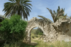
The village's built environment was largely destroyed. Walid Khalidi's description records surviving sections of crumbling walls, rubble, and the visible route of the old village road.
Israeli Settlement on Kawkaba's Lands
In 1950, the Israeli settlement of Kokhav Mikha'el was established on Kawkaba's lands, southeast of the former village site.
The Village Site after the Nakba
According to Walid Khalidi's description published in 1992, the village site was overgrown with sycamore and Christ's-thorn trees. The old road remained visible, together with crumbling walls and rubble in a wooded section of the site. Surrounding lands were cultivated by Israeli farmers.
This description reflects the condition documented by the source and should not be presented as a verified field description of the site in 2026 without a more recent reliable survey.
Kawkaba Today
The reviewed sources do not provide a recent field survey of Kawkaba's site as of 2026. The latest documented description available in these sources states that sycamore and Christ's-thorn trees cover the village site, while the old road remains visible alongside crumbling walls and debris in a wooded section. The surrounding lands are used for cultivation. This description is based on Walid Khalidi's documentation published in All That Remains.
Sources
- PalQuestPalQuest – Kawkaba
- PalQuestPalQuest – Operation Barak
- PalQuestPalQuest – Operation Yoav
- Palestine RememberedPalestine Remembered – Kawkaba, Gaza District
- Palestine RememberedKawkaba entry based on Walid Khalidi's All That Remains
- Walid Khalidi, All That Remains, Institute for Palestine Studies, 1992.
- Government of Palestine, Department of Statistics, Village Statistics, 1945.
Photo gallery


Photos from the village's people
Photos sent in by visitors and published after review.
Add a photo of this village
Log in to add photos of this village.
Other villages from Gaza
More from the archive


 Download Our Palestine App
The whole archive in the palm of your hand: depopulated villages, the Nakba, the massacres and Al-Aqsa — free, with no ads to erase the story.
Download Our Palestine App
The whole archive in the palm of your hand: depopulated villages, the Nakba, the massacres and Al-Aqsa — free, with no ads to erase the story.



Comments
No comments yet — be the first to write one.
Add your comment
Name and email are optional. Comments appear after review.