
The depopulated village of Al-Jura (Gaza) / District of Gaza

Al-Jura (Gaza)
About the depopulated village of Al-Jura (Gaza)
- District
- Gaza
- Date Al-Jura (Gaza) was occupied
- 04 November 1948
- Population in 1948
- 2,807
- Military operation
- Operation Yoav
- Brigade that carried it out
- Not identified in the sources; Operation Yoav was carried out by the Givati, Yiftach, Negev and Harel Brigades
- Distance from the governorate centre
- 20 km northeast of Gaza
- Elevation above sea level
- 25 m
- Cause of displacement
- Direct military assault by Israeli occupation forces: preliminary air attacks on the whole coastal area, then the occupation of the village, whose inhabitants probably fled to the Gaza Strip
- Settlements built on the built-up area of Al-Jura (Gaza) after 1948
- The city of Ashqelon, established in 1948 on village lands
Hover a dot to read the village name, or click to open its card.
Borders of the depopulated village of Al-Jura (Gaza)
Subdistrict: Gaza
- Subdistrict
- Gaza
- Distance from district center
- 20 km northeast of Gaza
- Average Elevation
- 25 m above sea level
- Population in 1931
- 1,754
- Number of Houses in 1931
- 396
- Population in 1944/1945
- 2,420 – according to Palestine Remembered; the village's PalQuest page shows the figures of al-Jura in the Jerusalem subdistrict by mistake
- Estimated Population in 1948
- About 2,807 – a later demographic estimate, not an official census
- Total Land Area in 1945
- 12,224 dunams – 10,705 Arab-owned and 1,519 public land
- Attack and Depopulation
- Israeli aircraft bombed the village at the outset of Operation Yoav, in which it was one of the first targets bombed according to an Egyptian communiqué, and United Press International reported from Cairo on 15 October 1948 that it had been bombed along with Gaza and al-Majdal. It was then almost certainly occupied, according to Khalidi, when al-Majdal was occupied on 4–5 November 1948, at the end of the operation, and its inhabitants probably fled to the Gaza Strip as a result of the occupation and the preliminary air attacks on the whole coastal area.
- Final Israeli Control
- 4–5 November 1948, when al-Majdal was occupied at the end of Operation Yoav; Khalidi states that the village was 'almost certainly' occupied at the same time, and the available sources do not give the day on which Israeli occupation forces entered it
- Military Operation
- Operation Yoav
- Military Unit
- The available sources do not identify the unit that occupied the village; PalQuest names the Givati Brigade, the Yiftach Brigade, the Negev Brigade and the Harel Brigade as the units that carried out Operation Yoav
- Cause of Depopulation
- Direct military assault by Israeli occupation forces: preliminary air attacks on the whole coastal area, then the occupation of the village, whose inhabitants probably fled to the Gaza Strip
- Settlements Documented on Village Lands
- The city of Ashqelon, established in 1948 on village lands
Population in 1948: Approximately 2,807
Date of occupation and depopulation: 4–5 November 1948
Military operation: Operation Yoav
Attacking force: Givati Brigade
Settlements established on village land before 1948: None
Present locality on the village site and land: The western expansion of Ashkelon
Modern neighbourhoods reported within the former village area: Eshkol Paz, Ramat Ben-Gurion, Shimshon, Neve Alonim, Neve Yam, and Afridar
Al-Jura, also known historically as Jurat ‘Asqalan, was a Palestinian coastal village in the Gaza Subdistrict. Israeli forces occupied and depopulated it on 4–5 November 1948, during the final stage of Operation Yoav.
Geography of al-Jura
Al-Jura was situated approximately 20 kilometres northeast of Gaza and five kilometres west of al-Majdal ‘Asqalan. It stood on level ground less than one kilometre from the Mediterranean coast and was surrounded by sandy hills and coastal dunes.
Because of its coastal location, al-Jura had cooler summer weather than inland localities. It consequently served as a summer resort for residents of nearby al-Majdal.
To the south lay a wide expanse of dunes known as Rimal ‘Asqalan, or the Sands of Ascalon, formed through the gradual movement and accumulation of coastal sand.
Boundaries of al-Jura
Al-Jura was bordered by the following villages, towns, and geographical features:
- North: Hamama.
- West: the Mediterranean Sea.
- South: Khirbat al-Khisas.
- Southeast: Ni‘ilya.
- East and northeast: al-Majdal ‘Asqalan.
Historical and Architectural Development
Al-Jura was also known as Jurat ‘Asqalan to distinguish it from other Palestinian villages bearing the same name. The village is recorded in late sixteenth-century Ottoman documents under forms including Jawra and Jawrit al-Hajja. It belonged to the nahiya and liwa of Gaza and had an estimated population of 253 in 1596.
In the late nineteenth century, al-Jura was described as a rectangular village situated on flat ground on the outskirts of ancient Ascalon. Its inhabitants built their houses from adobe bricks and stone obtained from the ruins and archaeological sites surrounding Ascalon.
Landmarks and Public Buildings
The village had a mosque with a two-room guesthouse attached to it for the accommodation of travellers and visitors. The mosque, school, and marketplace were all situated in the centre of the village.
Education in al-Jura
An elementary school was established in al-Jura in 1919. By the mid-1940s, it had an enrolment of 206 pupils. The school formed part of the central institutional area of the village alongside its mosque and market.
Religious and Archaeological Sites
Al-Jura and the adjoining landscape of historical Ascalon contained numerous archaeological remains and religious sites. Local tradition associated the area with several shrines, including the shrines of Shaykh ‘Awwad, Shaykh Muhammad, Shaykh Hasan, Shaykh Burhan, and al-Sayyida Khadra.
The best-known religious tradition was associated with the shrine known as Mashhad al-Husayn. An annual spring mawsim was held in the village in April. Visitors from Gaza, al-Majdal, and numerous surrounding villages attended for religious observances, swimming, sporting activities, celebrations, and trade. A special market was organized during the festival.
The village was also associated with Wadi al-Naml and with archaeological remains belonging to ancient Ascalon. Some traditions concerning individual shrines vary between local oral accounts and published historical studies.
Economic Life in al-Jura
Al-Jura had a diversified economy. Fishing and bird hunting were among its inhabitants’ principal occupations, and fish and game were sold in neighbouring towns and villages. The village was considered one of Palestine’s important coastal fishing centres.
Residents also made fishing nets, baskets, and other handicrafts connected with the coastal economy. Agriculture was another major source of livelihood. The villagers cultivated both rain-fed and irrigated crops, including citrus fruit, grapes, apricots, apples, almonds, vegetables, onions, and cereals.
In 1944/45, 481 dunams were devoted to citrus and bananas, 7,198 dunams were irrigated or planted with orchards, and 2,965 dunams were allocated to cereals.
Land Ownership in al-Jura
- Palestinian-owned10,705 dunums88%
- Jewish-owned0 dunums0%
- Public land1,519 dunums12%
* One dunam equals approximately 1,000 square metres.
Land Use in al-Jura in 1945
| Type of land use | Palestinian land (dunams)* |
|---|---|
| Citrus and banana plantations | 481 |
| Irrigated land and orchards | 7,198 |
| Cereal cultivation | 2,965 |
| Built-up area | 45 |
| Cultivable land | 10,644 |
| Uncultivable land | 1,535 |
* One dunam equals approximately 1,000 square metres. Citrus plantations form part of the broader irrigated-land and orchard category and should not be added to it when calculating the total cultivable area.
Population of al-Jura
Al-Jura had 1,326 inhabitants in the 1922 census. The population rose to 1,754 in 1931 and 2,420 in 1945. All the inhabitants recorded in the 1945 statistics were Palestinian Muslims. The estimated population at the time of the Nakba was approximately 2,807.
- 1596253
- 19221,326
- 19311,754
- 19452,420
- 1948 estimate2,807
- Estimated number of refugees in 199817,239
* The figures for 1948 and 1998 are demographic estimates rather than contemporary census counts.
Number of Houses in al-Jura
- 1931396
- 1948 estimate633
Occupation and Depopulation of al-Jura
Al-Jura was subjected to aerial bombardment during Operation Yoav. According to an Egyptian communiqué reported by the press, it was among the operation’s earliest targets. On 15 October 1948, a report from Cairo stated that Israeli aircraft had bombed al-Jura together with Gaza and al-Majdal.
The village was almost certainly occupied alongside al-Majdal on 4–5 November 1948, at the end of Operation Yoav. The attacking force is identified as the Givati Brigade. Its inhabitants most probably fled or were displaced towards the Gaza Strip as a result of the occupation and the preceding aerial attacks along the coastal region.
The frequently cited date of 5 November therefore falls within the documented occupation period, although 4 November is also given in village databases and military chronologies. It is most accurate to present the event as occurring on 4–5 November 1948.
Occupation and Depopulation Chronology
- 15 October 1948
Beginning of the military operation
Operation Yoav began as the second truce ended; the Israeli army had assembled the Givati, Negev and Yiftach brigades for it east of the coast between Isdud and Gaza, while Egyptian units controlled the coastal strip as far north as Isdud. PalQuest lists al-Jura among the villages affected by the operation.
- 15 October 1948
Aerial bombing of the village
Al-Jura was one of the first targets bombed during Operation Yoav, according to an Egyptian communiqué quoted in the New York Times; on 15 October, United Press International reported from Cairo that Israeli planes had bombed the village, along with Gaza and al-Majdal.
- Probably October–November 1948
Depopulation of the village
Khalidi considers it probable that the villagers fled to the Gaza Strip as a result of the occupation and the preliminary air attacks on the whole coastal area; the available sources do not give the day they left.
- 4–5 November 1948
Final occupation
The village was almost certainly occupied, according to Khalidi, when al-Majdal was occupied at the end of Operation Yoav; the available sources do not identify the unit that entered it.
- 1948
Settlement on village lands
The city of Ashqelon was established on village lands, according to Khalidi, and its buildings have spread over parts of the village site.
Localities Established on the Land of al-Jura
No Zionist settlement was established on al-Jura’s land before 1948. After the village’s occupation and depopulation, the expanding city of Ashkelon spread across its site and agricultural land.
The western urban expansion reported within the former village area includes the neighbourhoods of Eshkol Paz, Ramat Ben-Gurion, Shimshon, Neve Alonim, Neve Yam, and Afridar. These are urban neighbourhoods within Ashkelon rather than separate agricultural settlements. Their precise relationship to individual village parcels should be determined from cadastral maps rather than treating every neighbourhood as occupying the original built-up site.
Al-Jura Today
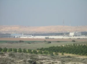
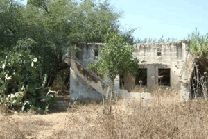
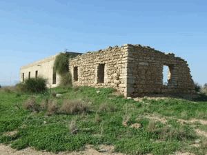
According to Walid Khalidi’s survey, only one village house remained standing by the early 1990s. Thorny shrubs and other vegetation covered the portions of the site that had not been built over, while the expansion of Ashkelon occupied most of the village area.
Some physical features associated with al-Jura’s landscape, including wells, irrigation pools, cemetery remains, and the shrine of Shaykh ‘Awwad, have also been documented. Nevertheless, the village’s original architectural fabric was overwhelmingly destroyed or absorbed into subsequent urban development.
Sources
- Palestine RememberedPalestine Remembered: al-Jura, Gaza Subdistrict
- Institute for Palestine StudiesInstitute for Palestine Studies: All That Remains
- Walid Khalidi, ed., All That Remains: The Palestinian Villages Occupied and Depopulated by Israel in 1948, Institute for Palestine Studies, 1992, pp. 117–118.
- Government of Palestine, Department of Statistics, Village Statistics, April 1945.
- Government of Palestine, Census of Palestine, 1922 and Census of Palestine, 1931.
Photo gallery


Photos from the village's people
Photos sent in by visitors and published after review.
Add a photo of this village
Log in to add photos of this village.
More from the archive


 Download Our Palestine App
The whole archive in the palm of your hand: depopulated villages, the Nakba, the massacres and Al-Aqsa — free, with no ads to erase the story.
Download Our Palestine App
The whole archive in the palm of your hand: depopulated villages, the Nakba, the massacres and Al-Aqsa — free, with no ads to erase the story.



Comments
No comments yet — be the first to write one.
Add your comment
Name and email are optional. Comments appear after review.