
The depopulated village of Al-Sawafir al-Sharqiyya / District of Gaza

Al-Sawafir al-Sharqiyya
About the depopulated village of Al-Sawafir al-Sharqiyya
- District
- Gaza
- Date Al-Sawafir al-Sharqiyya was occupied
- 18 May 1948
- Population in 1948
- 1,125
- Military operation
- Operation Barak
- Brigade that carried it out
- Givati Brigade
- Distance from the governorate centre
- 32 (km) North East of Gaza
- Elevation above sea level
- 50 m
- Cause of displacement
- Fear of Jewish attack, or of being caught in the fighting
- Extent of destruction
- The village has been completely defaced.
- Ethnic cleansing
- al-Sawafir al-Sharqiyya inhabitants were completely ethnically cleansed.
- Settlements built on the built-up area of Al-Sawafir al-Sharqiyya after 1948
- Ein Tzurim, Shafir, Zrachia, Nir Banim
Hover a dot to read the village name, or click to open its card.
Borders of the depopulated village of Al-Sawafir al-Sharqiyya
al-Sawafir al-Sharqiyya: A Depopulated Palestinian Village in the Gaza District
al-Sawafir al-Sharqiyya was a Palestinian village in the Gaza District, located approximately 32 km northeast of Gaza city on the southern coastal plain, at an average elevation of about 50 metres above sea level. Its inhabitants were displaced during the Nakba and the occupation of Palestine in 1948. Walid Khalidi and PalQuest place its occupation by units of the Giv'ati Brigade on 18 May 1948 during the second stage of Operation Barak.
Location of al-Sawafir al-Sharqiyya
al-Sawafir al-Sharqiyya stood on the southern coastal plain immediately south of the highway leading southwest toward al-Majdal and Gaza and northeast toward Ramla and Jerusalem.
The village was approximately 32 km northeast of Gaza city and had an average elevation of about 50 metres above sea level.
It was one of three neighbouring Palestinian villages bearing the name al-Sawafir: al-Sawafir al-Sharqiyya, al-Sawafir al-Gharbiyya, and al-Sawafir al-Shamaliyya. Together, the three villages formed an approximately right-angled triangle whose longest side ran northwest to southeast.
The designation al-Sharqiyya, meaning “eastern,” distinguished the village from its western and northern sister villages.
al-Sawafir al-Sharqiyya during the Ottoman Period
In 1596, al-Sawafir al-Sharqiyya was a village in the nahiya of Gaza within the liwa of Gaza.
Its inhabitants paid taxes on vineyards and on agricultural products including wheat, barley, fruit, and cotton.
The principal approved sources used here do not provide a sufficiently verified population figure for the village in 1596, so no uncertain estimate is included in the population table.
Architecture and Local Services
By the late nineteenth century, al-Sawafir al-Sharqiyya contained several small gardens and wells.
The inhabitants were Muslim. Most village houses were constructed of adobe brick, although some were built of stone.
The village had a mosque, while its wells supplied water for local needs and supported agricultural activity.
Education in al-Sawafir al-Sharqiyya
al-Sawafir al-Sharqiyya shared a school with al-Sawafir al-Gharbiyya and al-Sawafir al-Shamaliyya.
The shared school enrolled approximately 280 pupils by the mid-1940s. This figure refers to the school serving all three Sawafir villages rather than to pupils from al-Sawafir al-Sharqiyya alone.
Economic Life in al-Sawafir al-Sharqiyya
Agriculture, primarily rainfed cultivation, formed the backbone of the village economy. The villagers grew cereals, citrus fruit, grapes, and apricots and also made use of the orchards and wells in the surrounding area.
According to the 1944/45 statistics, 930 dunums were devoted to citrus and bananas, while 386 dunums were irrigated or used for plantations.
A total of 11,924 dunums was devoted to cereals, consisting of 11,821 Arab dunums and 103 dunums classified as Jewish-owned.
Land Ownership in al-Sawafir al-Sharqiyya
The total land area of al-Sawafir al-Sharqiyya was 13,831 dunums according to the 1944/45 statistics.
Land ownership in al-Sawafir al-Sharqiyya, 1944/45
- Arab13,200 dunums95%
- Transferred to Zionists
103 dunums<1% - Public528 dunums4%
In its Arabic table, Palestine Remembered presents the corresponding categories as 13,200 Palestinian dunums, 103 dunums “transferred to Zionists,” and 528 dunums of communal land.
Land Use in al-Sawafir al-Sharqiyya, 1944/45
Land use in al-Sawafir al-Sharqiyya according to PalQuest
- Arab
- Jewish
- Public
- Citrus and bananas930 dunums
- Plantations and irrigable land386 dunums
- Cereals11,924 dunums
- Built-up area40 dunums
- Non-cultivable land551 dunums
A total of 13,240 dunums, approximately 96 percent of the village lands, was cultivated or cultivable: 13,137 Arab dunums and 103 Jewish dunums.
Built-up and non-cultivable areas together amounted to 591 dunums.
Palestine Remembered presents 551 dunums of non-arable land in its Palestinian column. PalQuest's detailed table shows that this figure actually consists of 23 Arab dunums and 528 public dunums, and the categories are therefore separated here.
Population of al-Sawafir al-Sharqiyya
Population of al-Sawafir al-Sharqiyya in selected years
- 1922588Official British Mandate census
- 1931787Official British Mandate census
- 1944/45970Official statistics; all recorded inhabitants were Arab
- 19481,125Later estimate published by Palestine Remembered
- Estimated refugees in 19986,910Later estimate published by Palestine Remembered
Number of Houses in al-Sawafir al-Sharqiyya
Number of houses in al-Sawafir al-Sharqiyya
- 1931148Official British Mandate census figure
The principal approved sources used here do not provide a separately verified figure for the number of houses in 1948, so no unconfirmed estimate is included.
Occupation and Depopulation of al-Sawafir al-Sharqiyya during the Nakba
Units of the Giv'ati Brigade occupied al-Sawafir al-Sharqiyya during the second stage of Operation Barak, which targeted numerous Palestinian villages on the southern coastal plain in May 1948.
According to the account reproduced by Walid Khalidi and PalQuest, Operation Barak began on 9 May 1948. It was conducted mainly by the Giv'ati Brigade, with participation by the Palmach's Negev Brigade. A second stage of attacks continued in southern Palestine after British forces withdrew on 15 May.
Khalidi considers 18 May 1948 the probable date on which Giv'ati units occupied al-Sawafir al-Sharqiyya. He cites an Israeli source stating that most inhabitants had left by then and that some of those who remained were probably expelled. The Israeli source is not used independently here; the account is included only because it is reproduced in the approved Palestinian reference.
An Egyptian account cited by Khalidi differs substantially, placing the occupation roughly two weeks after the beginning of the first truce, around 25 June 1948.
This alternative account appears in the memoirs of Gamal Abdel Nasser, who at the time served as a staff officer in the Egyptian Army's Sixth Battalion. Abdel Nasser criticized the Egyptian command for having allowed Israeli occupation forces, in his account, to take the position during the truce.
At the end of the first truce on 9 July, the Sixth Battalion was ordered to attempt to recapture al-Sawafir al-Sharqiyya. The planned attack was never carried out as intended because a Sudanese unit failed to capture Bayt Daras.
During this period, Abdel Nasser, accompanied by two officers and two sergeants, carried out a reconnaissance mission behind Israeli occupation lines to inspect al-Sawafir al-Sharqiyya and al-Sawafir al-Gharbiyya. The patrol found that the military presence in the two villages was limited, but its intelligence was not used because the Egyptian advance had stalled at Bayt Daras.
- Probable occupation date according to Khalidi/PalQuest: 18 May 1948.
- Alternative Egyptian account: approximately 25 June 1948.
- Military operation: Operation Barak, second stage.
- Probable occupying force: units of the Giv'ati Brigade.
- Fate of the inhabitants: most had left by the time of occupation according to the cited account, while some of those remaining were probably expelled.
- Attempts to recapture the area: an Egyptian-Sudanese plan was prepared in July 1948 but failed to regain the village.
- Fate of the village: all of its houses were subsequently destroyed.
Because of the clear discrepancy between the 18 May account and the Egyptian version placing the occupation around 25 June, this article uses 18 May as the date favored by Khalidi's detailed PalQuest entry while explicitly preserving the alternative account.
Settlements Established on the Lands of al-Sawafir al-Sharqiyya
Walid Khalidi notes that locating settlements precisely within the lands of the three Sawafir villages can be complicated because of later name changes. Nevertheless, he identifies four settlements as having been established on the lands of al-Sawafir al-Sharqiyya:
- En Tzurim: established in 1949 on the village site itself.
- Shafir: established in 1949 on village lands.
- Zerachya: established in 1950.
- Nir Banim: established farther east in 1954.
al-Sawafir al-Sharqiyya Today
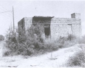
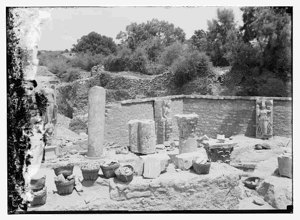
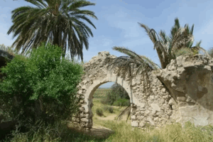
According to the field description published by Walid Khalidi in All That Remains, none of the village houses remained standing at the site.
New buildings had been erected on the spot where the village mosque once stood. Some traces of the former village nevertheless remained on surrounding lands.
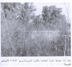
The features recorded by Khalidi included a building housing a water pump in Isma'il al-Sawafiri's orchard, an old sycamore tree in the orchard of the al-Buhaysi family, and an old cypress tree standing in an otherwise vacant field.
This principal description derives from field research published in Khalidi's book in 1992. The approved sources used here do not provide a sufficiently comprehensive and independent recent field survey to verify the precise condition of every part of the al-Sawafir al-Sharqiyya site in 2026.
The description should therefore be treated as historical documentation of the surviving features recorded at the time rather than as a comprehensive real-time account of the site today.
Sources
- PalQuestPalQuest – Interactive Encyclopedia of the Palestine Question: al-Sawafir al-Sharqiyya
- PalQuestPalQuest – Operation Barak
- Palestine RememberedPalestine Remembered – al-Sawafir al-Sharqiyya, Gaza District
- Palestine RememberedPalestine Remembered – al-Sawafir al-Sharqiyya entry from All That Remains
- Institute for Palestine StudiesInstitute for Palestine Studies – All That Remains, Walid Khalidi
Photos from the village's people
Photos sent in by visitors and published after review.
Add a photo of this village
Log in to add photos of this village.
Other villages from Gaza
More from the archive


 Download Our Palestine App
The whole archive in the palm of your hand: depopulated villages, the Nakba, the massacres and Al-Aqsa — free, with no ads to erase the story.
Download Our Palestine App
The whole archive in the palm of your hand: depopulated villages, the Nakba, the massacres and Al-Aqsa — free, with no ads to erase the story.



Comments
No comments yet — be the first to write one.
Add your comment
Name and email are optional. Comments appear after review.