
The depopulated village of Ibdis / District of Gaza
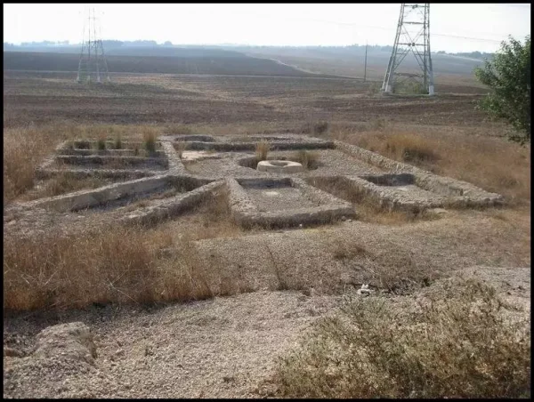
About the depopulated village of Ibdis
- District
- Gaza
- Date Ibdis was occupied
- 08 July 1948
- Military operation
- Operation Yoav
- Brigade that carried it out
- Givati Brigade
- Who defended the village
- Egyptian Army
- Distance from the governorate centre
- 30 (km) North East of Gaza
- Elevation above sea level
- 75 m
- Cause of displacement
- Military assault by Zionist troops
- Extent of destruction
- The village was completely obliterated.
- Ethnic cleansing
- 'Ibdis inhabitants were completely ethnically cleansed.
Hover a dot to read the village name, or click to open its card.
Borders of the depopulated village of Ibdis
'Ibdis – Depopulated Palestinian Village of the Gaza District
'Ibdis was a depopulated Palestinian village in the Gaza District. It stood on flat ground on the southern coastal plain approximately 30 kilometers northeast of Gaza, at an average elevation of about 75 meters above sea level. Wadi 'Ibdis bordered the village on the east.
The village was known for high-quality cereals and for its deep well, and it was connected by rural roads with al-Majdal and the Jaffa–Jerusalem highway.
After a series of attacks beginning in February 1948, the Third Battalion of the Giv'ati Brigade attacked 'Ibdis on the night of 8 July 1948. A long battle followed with two Egyptian army companies stationed in the village, and Israeli forces completed their seizure of the position in the early hours of 9 July. Egyptian forces attempted to recapture the village on 10 and 12 July, with conflicting accounts regarding a brief Egyptian recapture during the first attempt.
Location and Geography
'Ibdis stood on flat land on the southern coastal plain, surrounded by agricultural fields and seasonal watercourses.
It lay approximately 30 kilometers northeast of Gaza at an average elevation of about 75 meters above sea level.
Wadi 'Ibdis bordered the village on the east before flowing northward toward other wadis in the Sawafir area and ultimately into the Wadi Suqrir drainage system.
Two secondary roads linked the village with the main road connecting al-Majdal to the Jaffa–Jerusalem highway and also connected it with neighboring villages.
Nearby communities included al-Sawafir al-Gharbiyya to the north and northwest, al-Sawafir al-Sharqiyya to the northeast, Bayt 'Affa to the east and southeast, 'Iraq Suwaydan to the south, Kawkaba to the southwest, and Julis to the west.
The Palestinian Encyclopedia gives a distance of 43 kilometers from Gaza, whereas Walid Khalidi and PalQuest use approximately 30 kilometers. This article adopts the latter figure as the principal-source measurement.
Name and Earlier History
Walid Khalidi does not provide a conclusive linguistic explanation for the name 'Ibdis.
The Palestinian Encyclopedia states that the village arose on the ruins of a Canaanite locality called “Hadasha.” This identification does not appear in Khalidi's principal village account and is therefore not treated here as a conclusively established archaeological identification.
What is securely documented is the presence of ancient remains in and around the village, indicating occupation of the area well before the modern settlement.
Ottoman Period
In 1596, 'Ibdis belonged to the nahiya of Gaza in the liwa' of Gaza and had an estimated population of approximately 193.
The inhabitants paid taxes on wheat, barley, sesame, fruit, goats, beehives, vineyards, and other forms of production.
In the late nineteenth century, 'Ibdis was described as a moderately sized village standing on open ground.
Built Environment
Traditional houses in 'Ibdis were constructed largely of adobe and stood close together along narrow lanes.
During the final years of the Mandate, new houses were built along the secondary roads leading out of the village.
The official 1944/45 statistics classified approximately 18 dunams as built-up land.
Population and Houses
The inhabitants of 'Ibdis during the Mandate period were Muslims.
- 1596About 193Historical estimate derived from Ottoman records
- 1922319Official Census of Palestine; all inhabitants were Muslims
- 1931425Official census; all inhabitants were Muslims
- 1945540Official statistics; all inhabitants were Palestinian Arab Muslims
- 1948About 626Later demographic estimate, not an official Mandate census
- 1998About 3,847 refugees and descendantsLater estimate published by Palestine Remembered
The official 1931 census recorded 62 inhabited houses in 'Ibdis.
The estimate of approximately 91 houses for 1948 is a later calculation rather than an official Government of Palestine census figure.
Education
Walid Khalidi does not document an independent government school inside 'Ibdis.
Supporting Palestinian local documentation records a traditional kuttab in the eastern quarter near the village well. A teacher from the Sawafir area taught Qur'anic studies and arithmetic, receiving payment from families in the form of grain.
The same local documentation states that after 1944 children from 'Ibdis attended the elementary school at 'Iraq Suwaydan, a privately established school founded in 1942 that also served Bayt 'Affa. Combined enrollment from the three villages reportedly reached about 104 pupils in the late 1940s.
These details are presented as supporting Palestinian community documentation because they are not included in Khalidi's principal statistical entry.
Water Resources
The inhabitants obtained drinking water from a deep village well approximately 55 meters deep.
Although groundwater was available in the area, relatively few wells had been drilled.
Agriculture therefore remained largely dependent on rainfall, with limited irrigation used for orchards.
Economic Life and Agriculture
Agriculture was the foundation of the village economy, and 'Ibdis was especially known in the Gaza region for the quality of its grain.
The villagers cultivated wheat, barley, sorghum, lentils, and, according to Ottoman records, sesame.
During the later Mandate period, fruit-tree cultivation expanded to include grapes, apricots, and oranges.
The Palestinian Encyclopedia also records olives, particularly in agricultural areas northwest of the village.
Land Ownership, 1944/45
The total land area of 'Ibdis was 4,593 dunams.
- Arab4,493 dunums98%
- Jewish0 dunums0%
- Public100 dunums2%
The official figures balance exactly: 4,493 + 100 = 4,593 dunams.
Palestine Remembered presents the same ownership totals using its simplified terminology: 4,493 dunams “Palestinian,” 0 dunams “Transferred to Zionists,” and 100 dunams “Communal/Public.”
The phrase “Transferred to Zionists” should be preserved when reproducing that source's terminology.
Land Use, 1944/45
- Arab
- Public
- Cereals4,307 dunums
- Plantations and irrigable land149 dunums
- Total cultivable/cultivated land4,456 dunums
- Non-cultivable land119 dunums
- Built-up land18 dunums
- Total non-cultivable and built-up137 dunums
The official table balances exactly: 4,456 dunams of cultivated or cultivable land plus 137 dunams of built-up and non-cultivable land equal the total village area of 4,593 dunams.
Archaeological Sites
Old wells, cisterns, building foundations, and architectural fragments in and around 'Ibdis indicated a long history of settlement.
Abu Juway'id, near the village, is described by Walid Khalidi as probably a Byzantine site.
Khirbat 'Ajjas lay southwest of 'Ibdis and was mentioned by the thirteenth-century geographer Yaqut al-Hamawi as a village within the jurisdiction of Ascalon.
Early Attack on 'Ibdis
'Ibdis experienced a direct attack before the entry of the regular Arab armies into Palestine.
According to the Palestinian newspaper Filastin, Zionist forces arrived in three large vehicles on the night of 17 February 1948.
Local Palestinian fighters engaged them for approximately an hour and a half, after which the attackers withdrew toward Negba.
The newspaper account reported no casualties among the village defenders.
Attack during the First Truce
Egyptian sources record another attack on 'Ibdis on 11 June 1948, the first day of the First Truce.
Gamal Abdel Nasser, then an Egyptian officer serving on this front, later recalled that Israeli forces moved toward 'Ibdis because the Arab village projected into the Egyptian lines.
His account does not state that this attack resulted in the village's permanent occupation. Khalidi considers it likely that 'Ibdis remained in Egyptian hands until the July assault.
Occupation of 'Ibdis in July 1948
As the First Truce ended, the Giv'ati Brigade began a major southern advance intended to connect with Israeli forces in the Negev and expand its area of control.
On the night of 8 July 1948, the Third Battalion of the Giv'ati Brigade attacked 'Ibdis.
Two Egyptian army companies were stationed in the village, and a prolonged battle continued through the night.
According to the account cited by Khalidi, Israeli forces did not complete their seizure of the position until the early morning hours.
The most precise occupation dating is therefore the night of 8–9 July 1948, with 8 July representing the beginning of the assault.
Egyptian Attempts to Recapture 'Ibdis
Egyptian forces attempted to recapture the village on 10 July 1948.
The Israeli account states that the attempt failed with heavy Egyptian losses.
Egyptian writer Muhammad 'Abd al-Mun'im provides a different account, stating that Egyptian units briefly retook 'Ibdis but were forced to withdraw under fire from positions overlooking the village.
The temporary recapture is therefore recorded as a disputed account rather than an uncontested event.
A second Egyptian attempt to retake 'Ibdis on 12 July 1948 also failed.
Was 'Ibdis Captured during Operation Yoav?
Palestine Remembered and the Palestinian Villages Encyclopedia currently classify 'Ibdis under Operation Yoav.
This is chronologically impossible. Operation Yoav did not begin until 15 October 1948, whereas the decisive battle for 'Ibdis occurred on 8–9 July, more than three months earlier.
Operation Yoav is therefore not used here as the operation responsible for the occupation of 'Ibdis.
'Ibdis and Operation An-Far
The decisive attack on 'Ibdis occurred at the same time as the opening of Operation An-Far, which began on 8 July 1948 and was conducted by the Giv'ati Brigade on the southern front.
There is, however, an important attribution problem.
PalQuest's Operation An-Far entry does not list 'Ibdis among its affected villages, and the operation was launched by Giv'ati's First Battalion, whereas the village-specific 'Ibdis account explicitly identifies the Third Battalion as the formation that attacked the village.
The most precise formulation is therefore that 'Ibdis was captured during Giv'ati's southern offensive of 8–9 July, concurrent with the opening of Operation An-Far, without conclusively classifying the village as an An-Far village in the absence of explicit source attribution.
Military Unit and Defenders
The village-specific attacking formation was the Third Battalion of the Giv'ati Brigade.
The defenders included two companies of the Egyptian army stationed at 'Ibdis.
Because the village source identifies the battalion explicitly, the more general “Giv'ati Brigade” designation should not replace the more precise village-level attribution.
Depopulation
Walid Khalidi states that it is unclear whether the inhabitants of 'Ibdis were expelled during the 8–9 July battle itself.
The military narratives focus principally on the battle against Egyptian forces and on Egyptian military equipment captured by the Israeli units.
No unsupported detailed account of the civilians' departure is therefore added.
What is securely established is that the Palestinian population was ultimately displaced during the Nakba and the village was subsequently destroyed.
Occupation Chronology
- 17 February 1948
Early attack
A Zionist force arrived in three vehicles, fought local Palestinian defenders for about ninety minutes, and withdrew toward Negba.
- 11 June 1948
Attack during the First Truce
Egyptian sources record an Israeli move against 'Ibdis, but the village does not appear to have been permanently occupied at that stage.
- Night of 8 July 1948
Beginning of the decisive assault
The Third Battalion of the Giv'ati Brigade attacked two Egyptian army companies stationed in the village.
- Morning of 9 July 1948
Israeli seizure of the position
Fighting continued into the early morning, making 8–9 July the most precise occupation range.
- 10 July 1948
First Egyptian counterattack
Israeli and Egyptian accounts differ over whether Egyptian forces briefly recaptured the village before withdrawing.
- 12 July 1948
Second Egyptian counterattack
A second attempt to recover 'Ibdis failed.
- July 1948; precise day uncertain
Depopulation
The source does not clearly state whether the villagers were expelled during the 8–9 July assault itself, but the community was ultimately completely displaced.
- After occupation; exact date not documented
Destruction
The village houses were completely demolished.
Israeli Settlements on Village Lands
According to Walid Khalidi and PalQuest, no Israeli settlement was established on 'Ibdis village land itself.
Merkaz Shappira was established in 1948 on the boundary between the lands of 'Ibdis and al-Sawafir al-Gharbiyya.
The settlement cultivates some land near the former village site, but Khalidi's cadastral description explicitly states that it is not located on 'Ibdis village land.
It should therefore not be listed as a settlement established on the village's land, despite the way some secondary statistical pages categorize it.
'Ibdis Today
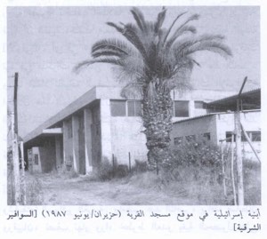
According to the field description published in Walid Khalidi's All That Remains, the houses of 'Ibdis had been completely destroyed.
The former village site could be identified only by a cluster of sycamore trees.
Part of the surrounding land was under cultivation at the time of the survey.
A general field photograph of the village site included in the documentation dates from 1987.
This account should not be treated as a comprehensive field verification of conditions in 2026. Fieldwork for All That Remains was conducted between 1987 and 1990 and therefore records the site's condition during that survey period.
Sources
- PalQuest – Interactive Encyclopedia of the Palestine Question: 'Ibdis
- PalQuest – Operation An-Far; for chronological and operational comparison
- PalQuest – Operation Yoav; used to correct the later erroneous classification
- Palestine Remembered – 'Ibdis, Gaza District
- Palestine Remembered – Walid Khalidi's account of 'Ibdis
- Palestinian Encyclopedia – 'Ibdis
- Palestinian Villages Encyclopedia – 'Ibdis; supporting Palestinian local documentation
- Institute for Palestine Studies – Walid Khalidi, All That Remains
- PalQuest – All That Remains: Methodology
Photos from the village's people
Photos sent in by visitors and published after review.
Add a photo of this village
Log in to add photos of this village.
Other villages from Gaza
More from the archive


 Download Our Palestine App
The whole archive in the palm of your hand: depopulated villages, the Nakba, the massacres and Al-Aqsa — free, with no ads to erase the story.
Download Our Palestine App
The whole archive in the palm of your hand: depopulated villages, the Nakba, the massacres and Al-Aqsa — free, with no ads to erase the story.



Comments
No comments yet — be the first to write one.
Add your comment
Name and email are optional. Comments appear after review.