
The depopulated village of Al-Manshiyya (Safed) / District of Safed

Al-Manshiyya (Safed)
About the depopulated village of Al-Manshiyya (Safed)
- District
- Safed
- Date Al-Manshiyya (Safed) was occupied
- 24 May 1948
- Military operation
- Operation Yiftach
- Brigade that carried it out
- Palmach
- Distance from the governorate centre
- 30 (km) North East of Safad
- Elevation above sea level
- 125 m
- Cause of displacement
- Influence of fall of, or exoduce from, neighboring town
- Extent of destruction
- The village has been completely defaced, and only house rubble left behind.
- Ethnic cleansing
- al-Manshiyya inhabitants were completely ethnically cleansed.
- Settlements built on the built-up area of Al-Manshiyya (Safed) after 1948
- Shomrat, Bustan HaGalil and the eastern neighbourhoods of Acre, including Neve Aviv, Moriah and Ben-Gurion. Local accounts also associate other adjoining neighbourhoods with the former village lands, although their precise boundaries require cadastral verification
Hover a dot to read the village name, or click to open its card.
Borders of the depopulated village of Al-Manshiyya (Safed)
Al-Manshiyya – A Depopulated Palestinian Village in the Safad Subdistrict
Al-Manshiyya was a Palestinian village in the Safad Subdistrict, situated at the northern edge of the al-Hula Plain approximately 30 km northeast of the city of Safad, at an average elevation of about 125 meters above sea level.
Its inhabitants were displaced during the Nakba and the occupation of Palestine in 1948, in the context of Operation Yiftach in eastern Galilee. Walid Khalidi records that the villagers left on 24 May 1948, one day before the operation ended.
- Subdistrict
- Safad
- Distance from Safad
- Approximately 30 km northeast
- Average elevation
- Approximately 125 m above sea level
- Physical setting
- Northern edge of the al-Hula Plain
- Documented date of population departure
- 24 May 1948
- Military operation
- Operation Yiftach
- Military unit
- Khalidi's village entry does not independently identify a village-specific assault unit; the Palmach First Battalion spearheaded Operation Yiftach generally
- Israeli settlements established on village land
- None identified by Khalidi
Location and Geography of Al-Manshiyya
Al-Manshiyya stood on uneven ground that sloped gently southward at the northern end of the al-Hula Plain. It lay near the road connecting the Palestinian village of al-Khalisa with the Syrian town of Banyas.
Palestinian sources and maps place al-Khalisa to its west, al-Khisas to the east, al-Sanbariyya roughly to the northeast, al-Zuq al-Fawqani to the northwest, and al-Zuq al-Tahtani to the south.
Al-Manshiyya before the Nakba
Al-Manshiyya was a relatively small rural settlement. The Palestine Index Gazetteer, compiled during the British Mandate, classified it as a hamlet.
The principal sources provide little additional documented detail about its internal built form or public institutions. There is insufficient reliable evidence in these sources to establish the existence and details of a formal school, mosque, or other public facilities.
Population of Al-Manshiyya
The official 1931 Census of Palestine recorded 72 inhabitants in al-Manshiyya living in 15 occupied houses.
PalQuest does not provide an independent population figure for al-Manshiyya in 1944/45, and the village does not appear as a separate entry in the Safad Subdistrict list in the published Village Statistics of 1945. A separate 1945 population total should therefore not be invented or inferred from neighboring statistical units.
Palestine Remembered gives a later estimate of 140 inhabitants for 1948 and estimates the number of refugees and their descendants at 862 in 1998. These are retrospective estimates rather than official British Mandate census figures.
| Year | Population | Nature of Figure / Notes |
|---|---|---|
| 1931 | 72 | Official Census of Palestine |
| 1944/45 | No independent figure available | Al-Manshiyya does not appear as a separate entry in the 1945 Village Statistics |
| 1948 | 140 | Later estimate reported by Palestine Remembered, not an official census |
| 1998 | 862 refugees | Later estimate of refugees and their descendants |
Number of Houses
- 193115Official Census of Palestine
The principal sources used here do not provide a sufficiently reliable figure for the number of houses in 1948. No estimate has therefore been derived from the population figures.
Land of Al-Manshiyya
PalQuest does not reproduce a separate 1944/45 land-ownership or land-use table for al-Manshiyya, and the village is not separately listed by name in the Safad section of the 1945 Village Statistics.
It is therefore not possible to provide a secure independent total for the village lands or to divide them into Arab, Jewish, and Public categories without separate cadastral documentation. Figures belonging to nearby villages or larger statistical units should not be assigned to al-Manshiyya merely to complete a land table.
Economic Life in Al-Manshiyya
The principal sources do not provide independent statistical information on crops or cultivated acreage in al-Manshiyya before 1948. In the absence of a separate land-use table, specific acreages for cereals, orchards, or irrigated land cannot be attributed to the village with confidence.
Its classification as a hamlet indicates its rural character, but this alone is not sufficient evidence for a detailed reconstruction of its agricultural economy. Unsupported economic activities have therefore not been added.
Education and Services
The main sources used for this article do not provide sufficiently documented evidence of a formal school in al-Manshiyya, its founding date, or pupil numbers. Nor do they provide enough information to reconstruct other public services with confidence.
Archaeological Remains
An archaeological site known as Tall al-Battikha was located approximately 800 meters west of al-Manshiyya. Khalidi records a large quantity of pottery fragments scattered across its surface, indicating the antiquity of human activity in the area.
The presence of these remains should not, however, be converted into a precise archaeological chronology without further documented archaeological research. The village entry establishes the existence of the site and pottery fragments but does not provide a detailed dating sequence.
Occupation of Palestine in 1948 and the Depopulation of Al-Manshiyya
Al-Manshiyya lay within the area targeted by Operation Yiftach in eastern Galilee. The operation began on 15 April 1948 and ended on 25 May. Palmach forces played the main military role, and the Palmach First Battalion served as the spearhead of the operation generally.
Walid Khalidi states that al-Manshiyya, like other villages in the Safad Subdistrict, was affected by the psychological-warfare campaign and direct military assaults carried out during Operation Yiftach. He records that its inhabitants left on 24 May 1948, immediately before the operation ended.
Palestine Remembered lists 24 May as the village's occupation date. Khalidi's narrative, however, specifically identifies it as the date on which the villagers left and does not provide a separate chronology establishing the precise day on which military forces entered the site. It is therefore more accurate to treat 24 May as the documented date of population departure rather than automatically presenting it as a separately verified final occupation date.
Palestine Remembered also identifies the Palmach First Battalion as the attacking unit. Although that battalion is independently documented as the spearhead of Operation Yiftach generally, Khalidi's village-specific entry does not separately identify it as the unit that physically entered al-Manshiyya. The distinction between an operation-wide role and a village-specific assault should therefore be preserved.
- 15 April 1948
Beginning of Operation Yiftach
Operation aimed at seizing control of eastern Galilee
- 24 May 1948
Departure of al-Manshiyya's inhabitants
Date recorded by Khalidi for the villagers' departure
- Not separately dated
Direct military occupation
The principal village entry does not distinguish a separate military-entry date from the population departure
- 25 May 1948
End of Operation Yiftach
The operation ended one day after the recorded departure from al-Manshiyya
Israeli Settlements near Al-Manshiyya
Walid Khalidi does not identify any Israeli settlement as having been established on the lands of al-Manshiyya itself.
Beyt Hillel: Established in 1940 approximately one kilometer south of al-Manshiyya. It was founded on land belonging to the neighboring Palestinian village of al-Zuq al-Tahtani, not on al-Manshiyya's land.
Ha-Gosherim: Established in 1948 approximately two kilometers east of the village site. Khalidi explicitly states that it was not established on al-Manshiyya's land.
Although inhabitants of these settlements later used land around the village site, geographical proximity should not be confused with a documented foundation on al-Manshiyya's own lands.
Al-Manshiyya Today
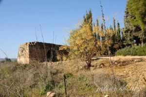
According to the field description published by Walid Khalidi in All That Remains, no recognizable village landmarks remained at the site. Grass and some eucalyptus trees covered the former village area, while surrounding lands were being used for cotton cultivation by residents of Beyt Hillel and Ha-Gosherim.
This description derives from fieldwork conducted before the publication of All That Remains in 1992 and should not be treated as direct field verification of the site's condition in 2026. The principal sources used here do not provide a comprehensive recent field survey establishing that present land use remains identical to Khalidi's earlier description.
Sources
- PalQuestPalQuest – Interactive Encyclopedia of the Palestine Question: al-Manshiyya, Safad
- PalQuestPalQuest – Operation Yiftach
- Palestine RememberedPalestine Remembered – al-Manshiyya, Safad
- Palestine RememberedPalestine Remembered – al-Manshiyya entry from All That Remains
- Institute for Palestine StudiesInstitute for Palestine Studies – Walid Khalidi, All That Remains
- fada.birzeit.eduBirzeit University Repository – Census of Palestine 1931: Population of Villages, Towns and Administrative Areas
- pcbs.gov.psPalestinian Central Bureau of Statistics – Historical Census Reports
Photos from the village's people
Photos sent in by visitors and published after review.
Add a photo of this village
Log in to add photos of this village.
Other villages from Safed


More from the archive



 Download Our Palestine App
The whole archive in the palm of your hand: depopulated villages, the Nakba, the massacres and Al-Aqsa — free, with no ads to erase the story.
Download Our Palestine App
The whole archive in the palm of your hand: depopulated villages, the Nakba, the massacres and Al-Aqsa — free, with no ads to erase the story.



Comments
No comments yet — be the first to write one.
Add your comment
Name and email are optional. Comments appear after review.