
The depopulated village of Al-Muftakhira / District of Safed
Al-Muftakhira
About the depopulated village of Al-Muftakhira
- District
- Safed
- Date Al-Muftakhira was occupied
- 01 May 1948
- Population in 1948
- 410
- Military operation
- Operation Yiftach
- Brigade that carried it out
- Palmach
- Distance from the governorate centre
- 25.5 (km) North East of Safad
- Elevation above sea level
- 75 m
- Cause of displacement
- Fear of Jewish attack, or of being caught in the fighting
- Extent of destruction
- The village has been completely destroyed, and only house rubble left behind.
- Ethnic cleansing
- al-Muftakhira was ethnically cleansed over two phases: the 1st was in early May and the 2nd was on the 16th of May 1948.
- Settlements built on the land of Al-Muftakhira before 1948
- Shamir
Hover a dot to read the village name, or click to open its card.
Borders of the depopulated village of Al-Muftakhira
Al-Muftakhira – A Depopulated Palestinian Village in the Safad Subdistrict
Al-Muftakhira was a Palestinian village in the Safad Subdistrict, located approximately 25.5 km northeast of Safad in the central-eastern part of the Hula Plain, at an average elevation of about 75 meters above sea level.
The village stood on flat terrain near the Palestine–Syria frontier of the Mandate period. Agriculture formed the basis of its economy, and a nearby stream—identified in later Palestinian local documentation as Nahr al-Kali—provided water for drinking and irrigation.
Al-Muftakhira's population dispersed in two principal waves, on 1 May and 16 May 1948, during Operation Yiftach. Khalidi's account attributes the departure to fear of a Zionist attack, mortar fire, or being caught in the fighting.
- Subdistrict
- Safad
- Distance from Safad
- Approximately 25.5 km northeast
- Average elevation
- Approximately 75 m above sea level
- Population, 1931
- 231
- Population, 1944/45
- 350; the statistical figure includes al-Barjiyyat
- Estimated population, 1948
- 406
- Total land area, 1944/45
- 9,215 dunums; includes al-Barjiyyat
- First wave of displacement
- 1 May 1948
- Final wave of depopulation
- 16 May 1948
- Military operation
- Operation Yiftach
- Military force
- Palmach / Yiftach forces at operation level; the First Battalion spearheaded the wider operation, while Khalidi's village entry does not conclusively identify a village-specific assault unit
- Settlement established on village land
- Shamir, established in 1944
Location and Geography
Al-Muftakhira stood on flat terrain in the central-eastern Hula Plain close to the Syrian frontier.
Its location overlooked parts of the Hula landscape, with Syrian territory and the Golan to the east and the Hula lake and wetlands in the broader western and southwestern landscape.
Local tracks linked the village with neighboring communities, while nearby al-Khalisa served as an important market center for the people of the northern Hula Plain.
Neighboring Villages and Areas
| Direction | Village or Area |
|---|---|
| North | al-Dawwara |
| Northeast | al-Hamra' |
| East | Syrian territory / the Golan |
| South and southeast | Khiyam al-Walid |
| West | al-Zawiya |
| Northwest | al-Salihiyya |
These directions reflect approximate geographical relationships documented in Palestinian local sources and should not be treated as substitutes for historical cadastral boundaries.
Name of Al-Muftakhira
In Arabic, the name al-Muftakhira is the feminine form of the active participle derived from the verb iftakhara, “to take pride” or “to boast.”
The principal historical sources used here do not preserve a securely documented account explaining why this particular name was given to the village, so no speculative origin has been added.
Built Form
Al-Muftakhira's houses were closely clustered.
The older dwellings were constructed of adobe brick and roofed with cane, reflecting building techniques and materials common in parts of the Hula Plain.
Newer houses were built of stone, concrete, and other masonry materials during the later Mandate period.
Population of Al-Muftakhira
The official 1931 Census of Palestine recorded 231 inhabitants in al-Muftakhira, all Muslims, living in 51 occupied houses.
The 1944/45 Village Statistics recorded 350 inhabitants. An important statistical qualification is that this figure includes al-Barjiyyat. The same inclusion applies to the 1944/45 land-ownership and land-use figures.
Palestine Remembered later estimated the population at 406 in 1948 and the number of refugees and their descendants at 2,493 in 1998. These are retrospective estimates rather than official Mandate census counts.
- 1931231Official census; all Muslims
- 1944/45350Official statistics; includes al-Barjiyyat
- 1948406Later estimate, not an official census
- 19982,493 refugeesLater estimate of refugees and their descendants
Number of Houses
- 193151Occupied houses recorded in the official census
- 194889Later Palestine Remembered estimate, not an official Mandate count
Education
Khalidi records a small school in al-Muftakhira.
Later Palestinian documentary material adds useful detail. On 28 December 1946, village mukhtar Muhammad Hasan Mar'i al-Masri wrote to the Inspector of Education requesting a teacher for a school he had established in his own house.
A second letter dated 12 February 1947 concerned reopening the village school following repairs.
These documents indicate that local schooling existed and that villagers were actively seeking to regularize and staff it during the final years of the Mandate. The core sources used here do not provide a secure enrollment figure or a complete grade structure.
Economic Life
Agriculture was the principal source of livelihood. Villagers cultivated wheat, maize, onions, animal fodder, and other seasonal crops.
Some residents also raised livestock and fished, while others engaged in trade.
Many villagers attended the weekly Tuesday market in neighboring al-Khalisa to sell agricultural produce and purchase goods.
In 1944/45, 924 Arab dunums were devoted to cereals and 3,597 Arab dunums were irrigated or used for plantations.
Water and Nahr al-Kali
Khalidi records a stream near the village that supplied irrigation water.
Later Palestinian local documentation identifies this watercourse as Nahr al-Kali, describing it as flowing from Syrian territory toward al-Muftakhira and providing both drinking and irrigation water.
The availability of water helps explain the unusually large area devoted to irrigated land and plantations.
Land Ownership in 1944/45
The official statistical unit for al-Muftakhira, including al-Barjiyyat, contained 9,215 dunums.
Using Palestine Remembered's simplified terminology:
- Palestinian5,414 dunums59%
- Transferred to Zionists3,596 dunums39%
- Communal/Public205 dunums2%
The official Village Statistics use the original categories Arab, Jewish, and Public: 5,414 dunums were Arab land, 3,596 Jewish, and 205 public.
These figures include al-Barjiyyat and should therefore not be presented as an entirely separate cadastral total for al-Muftakhira alone.
Land Use in 1944/45
- Arab
- Jewish
- Public
- Plantations and irrigable land3,597 dunums
- Cereals2,767 dunums
- Built-up land0 dunums
- Non-cultivable land2,851 dunums
Cultivable land totaled 6,364 dunums, approximately 69 percent of the statistical unit: 4,521 Arab and 1,843 Jewish dunums.
Non-cultivable land totaled 2,851 dunums, approximately 31 percent: 893 Arab, 1,753 Jewish, and 205 public dunums.
The printed Village Statistics table displays 3,767 as the cereal total, but this is an evident arithmetic error: 924 + 1,843 equals 2,767. The corrected figure also reconciles exactly with the published cultivable-land total of 6,364 dunums.
Some simplified tables show 1,098 dunums as Palestinian non-arable land. That number combines 893 Arab dunums with 205 public dunums; the two categories have therefore been separated here.
Palestine Remembered also records two dunums of olive trees. This is a crop-specific subset of the agricultural land and should not be added independently to the statistical total.
Archaeological Remains
Khalidi records a nearby khirba containing building foundations and wall remains.
Palestine Remembered identifies the locality as Khirbat al-Hamra or al-Hamrawi and places it southeast of the village.
The principal source does not provide a secure archaeological chronology, so no specific historical period has been assigned to these remains.
Operation Yiftach
Operation Yiftach ran from 15 April to 25 May 1948 and was designed to establish Zionist control over eastern Galilee and the Hula region.
The operation was planned under Palmach commander Yigal Allon, and the Palmach's First Battalion spearheaded the wider campaign.
Operation Yiftach combined direct military attacks with psychological warfare. Between 10 and 15 May, a so-called “whispering campaign” was used to spread fear of an imminent assault and encourage Palestinians in the Hula region to leave.
PalQuest explicitly lists al-Muftakhira among the villages affected by Operation Yiftach.
Depopulation of Al-Muftakhira
Khalidi, citing Israeli historian Benny Morris, states that the villagers dispersed in two waves.
The first occurred on 1 May 1948, followed by a second and final wave on 16 May 1948.
The departure is attributed to fear of a Zionist attack, mortar fire, or becoming caught in the fighting during Operation Yiftach.
It is therefore more precise to treat 1 May as the beginning of the village's depopulation and 16 May as the date by which the second major wave had completed the process.
Military Unit
Operation Yiftach was a Palmach-led offensive in eastern Galilee, and PalQuest states that the Palmach's First Battalion spearheaded the operation.
Palestine Remembered and some later Palestinian secondary documentation identify the First Battalion as the attacking unit at al-Muftakhira on 16 May.
Khalidi's village-specific account, however, links the village's depopulation to Operation Yiftach without naming a specific battalion as the force that physically entered al-Muftakhira. The First Battalion is therefore securely identified as the principal force at the operation level, while the village-specific attribution should be treated with appropriate caution.
- 15 April 1948
Beginning of Operation Yiftach
Palmach offensive begins in eastern Galilee
- 1 May 1948
First wave of departure
Part of al-Muftakhira's population leaves
- 10–15 May 1948
Psychological-warfare campaign
“Whispering campaign” encourages flight from Hula communities
- 16 May 1948
Final wave of depopulation
Second major wave disperses the remaining population
- 25 May 1948
End of Operation Yiftach
End of the main campaign in eastern Galilee
Zionist Settlements on and near Al-Muftakhira's Lands
Shamir: Established in 1944 on al-Muftakhira's lands east of the village site.
Lahavot ha-Bashan: Established in 1945 close to al-Muftakhira to the south, but on land belonging to neighboring Khiyam al-Walid rather than al-Muftakhira.
The Arabic and English PalQuest versions differ over whether Lahavot ha-Bashan lay southwest or southeast of the village. This article therefore avoids overstating the exact direction and preserves the more important land-ownership distinction.
Al-Muftakhira Today
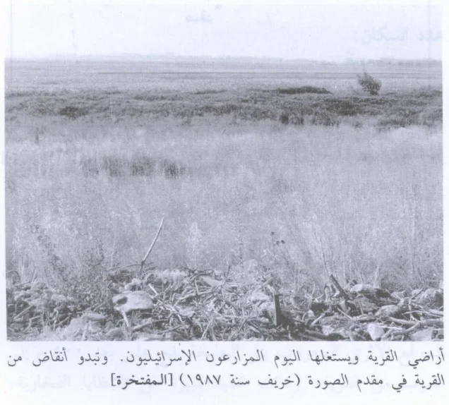
According to Walid Khalidi's field description in All That Remains, only stone rubble and occasional ruined walls remained to mark the former village.
A few eucalyptus trees grew on the site, which had been converted into an archaeological center, while surrounding lands were cultivated.
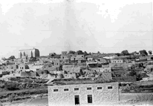
Palestine Remembered reproduces a documented photograph of the village ruins dated 1987, together with later community photographs of al-Muftakhira's lands.
Khalidi's description therefore provides a pre-1992 field baseline rather than direct verification of the site's condition in 2026. Later community material helps trace the landscape but does not constitute a comprehensive current archaeological or architectural survey.
Sources
- PalQuestPalQuest – Interactive Encyclopedia of the Palestine Question: al-Muftakhira
- PalQuestPalQuest – Operation Yiftach
- Palestine RememberedPalestine Remembered – al-Muftakhira, Safad
- Palestine RememberedPalestine Remembered – al-Muftakhira entry from All That Remains
- Palestine RememberedPalestine Remembered – 1946 letter requesting a teacher for al-Muftakhira's school
- Palestine RememberedPalestine Remembered – 1947 letter concerning reopening the village school
- Institute for Palestine StudiesInstitute for Palestine Studies – Walid Khalidi, All That Remains
- fada.birzeit.eduBirzeit University Repository – Census of Palestine 1931
- maktabatsabil.comGovernment of Palestine – Village Statistics 1945: Safad Sub-District, Population and Land Ownership
- maktabatsabil.comGovernment of Palestine – Village Statistics 1945: Safad Sub-District, Cultivable Land
- maktabatsabil.comGovernment of Palestine – Village Statistics 1945: Safad Sub-District, Built-up and Non-Cultivable Land
- palqura.comPalestinian Villages Encyclopedia – al-Muftakhira: local geography, water sources, population, and documentation
Photo gallery


Photos from the village's people
Photos sent in by visitors and published after review.
Add a photo of this village
Log in to add photos of this village.
Other villages from Safed
More from the archive



 Download Our Palestine App
The whole archive in the palm of your hand: depopulated villages, the Nakba, the massacres and Al-Aqsa — free, with no ads to erase the story.
Download Our Palestine App
The whole archive in the palm of your hand: depopulated villages, the Nakba, the massacres and Al-Aqsa — free, with no ads to erase the story.



Comments
No comments yet — be the first to write one.
Add your comment
Name and email are optional. Comments appear after review.