
The depopulated village of Sabalan / District of Safed

Sabalan
About the depopulated village of Sabalan
- District
- Safed
- Date Sabalan was occupied
- 30 October 1948
- Population in 1948
- 80
- Military operation
- Operation Hiram
- Brigade that carried it out
- The Seventh Brigade، Golani Brigade
- Distance from the governorate centre
- 15.5 (km) West of Safad
- Elevation above sea level
- 800 m
- Cause of displacement
- Military assault by Zionist troops
- Extent of destruction
- The village has been mostly destroyed with the exception of one house, a village well, and the shrine for al-Nabi Sabalan.
- Ethnic cleansing
- Sabalan inhabitants were completely ethnically cleansed.
Hover a dot to read the village name, or click to open its card.
Borders of the depopulated village of Sabalan
The Depopulated Palestinian Village of Sabalan
Sabalan was a Palestinian village in the Safad Subdistrict. It stood on a high mountain peak in Upper Galilee, approximately 15.5 kilometers west of Safad. The village was about 800 meters above sea level, and its lands covered a total area of 1,798 dunums.
All of Sabalan’s inhabitants were Muslims. Its population was 70 in 1945 and was estimated at approximately 81 in 1948. Israeli forces occupied the village on 30 October 1948 during Operation Hiram and displaced its inhabitants.
Location and Geography of Sabalan
Sabalan stood on a high mountain peak overlooking the predominantly Druze village of Hurfeish, which was located less than one kilometer to its northeast. Its lands were surrounded by those of Suhmata, Dayr al-Qasi, Ghabbatiyya, and al-Buqay‘a.
Dirt roads connected the village to the Safad–Tarshiha highway, located approximately three kilometers to the south. Other roads connected it to neighboring villages, particularly Sa‘sa‘ and Hurfeish.
Travelers who visited the area during the late nineteenth century described Sabalan as a stone-built village situated on top of a high hill. The village developed around a shrine attributed to al-Nabi Sabalan.
Architecture of Sabalan
The village had a circular layout, and its stone houses were clustered closely together. The steep slopes surrounding Sabalan prevented construction from expanding in most directions, so the built-up area developed mainly toward the northwest.
The village’s built-up area covered approximately 14 dunums. A mosque stood at its center, while the shrine of al-Nabi Sabalan was located in the central part of the village and surrounded by the residents’ homes.
Population of Sabalan
All of Sabalan’s inhabitants were Palestinian Muslims. Travelers estimated its population at approximately 100 during the late nineteenth century, while the 1922 census recorded 68 inhabitants.
The population increased to 94 in 1931. Official statistics recorded 70 inhabitants in 1945, while the village’s population at the time of its depopulation in 1948 was estimated at 81.
Population of Sabalan
- Late nineteenth century, estimated100
- 192268
- 193194
- 194570
- 1948, estimated81
- Estimated number of refugees and their descendants in 1998499
Number of Houses in Sabalan
Number of Village Houses
- 193118
- 1948, estimated18
Economic Life in Sabalan
The inhabitants of Sabalan depended primarily on agriculture for their livelihood. They cultivated cereals, figs, and olives on the agricultural land surrounding the village.
In 1944–1945, a total of 421 dunums was allocated to cereals, while 144 dunums were irrigated or used for orchards. Of the orchard land, 65 dunums were planted with olive trees.
Land Ownership in Sabalan
Land Ownership in 1945, in Dunums
- Palestinian ownership1,262 dunums70%
- Jewish ownership0 dunums0%
- Public land536 dunums30%
Land Use in Sabalan in 1945
Village Land Use in Dunums
- Orchards and irrigated land144 dunums6%
- Land planted with olive trees65 dunums3%
- Land planted with cereals421 dunums17%
- Built-up area14 dunums<1%
- Cultivable land565 dunums23%
- Non-cultivable land1,219 dunums50%
The land planted with olive trees was included within the orchard and agricultural land figures and should not be added separately when calculating the total area.
The Mosque and Shrine of al-Nabi Sabalan
A mosque serving the village’s Muslim population stood at the center of Sabalan. The village was also known for the shrine attributed to al-Nabi Sabalan, around which the village developed and from which it derived its name.
In later years, the shrine became an important religious site for the Druze community, and new buildings were constructed nearby to accommodate visitors.
Archaeological Sites in Sabalan
Archaeological remains, including rock-cut tombs, were discovered in the center of the village near the shrine of al-Nabi Sabalan. These remains indicate that the site had been inhabited during earlier historical periods.
The Occupation and Depopulation of Sabalan
Israeli forces occupied Sabalan on 30 October 1948 during Operation Hiram, an offensive aimed at occupying Upper and Central Galilee and reaching the Lebanese border.
Historian Walid Khalidi suggests that the village was probably overrun as units of the Golani Brigade advanced northwest along the road between Suhmata and Sa‘sa‘.
According to the Israeli military account, the Golani Brigade’s First Battalion reached Sa‘sa‘, where it met units of the Seventh Brigade that formed the eastern flank of Operation Hiram.
The military offensive resulted in the complete displacement of Sabalan’s inhabitants and the destruction of most of its houses. The available sources do not document a separate battle inside the village. It is therefore more accurate to state that Sabalan was probably occupied during the Golani Brigade’s advance, rather than identifying a particular unit as the confirmed force that entered the village.
Israeli Settlements on Sabalan’s Land
According to Walid Khalidi’s documentation, no Israeli settlements were established on Sabalan’s land. However, most of the village’s buildings were destroyed following the displacement of its inhabitants, and the area surrounding the shrine of al-Nabi Sabalan was developed as a religious site for visitors.
Sabalan Today
Only one village house and a well remain. The house stands opposite the shrine of al-Nabi Sabalan and has been used by the shrine’s guards and caretakers.
New buildings have been constructed around the shrine to accommodate visitors, while most physical traces of the Palestinian village disappeared following the destruction of its houses.
Photo gallery


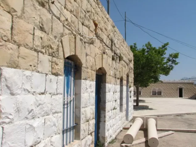


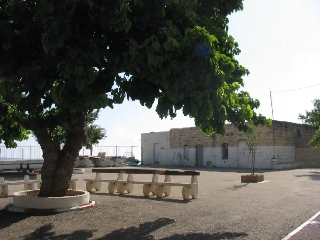

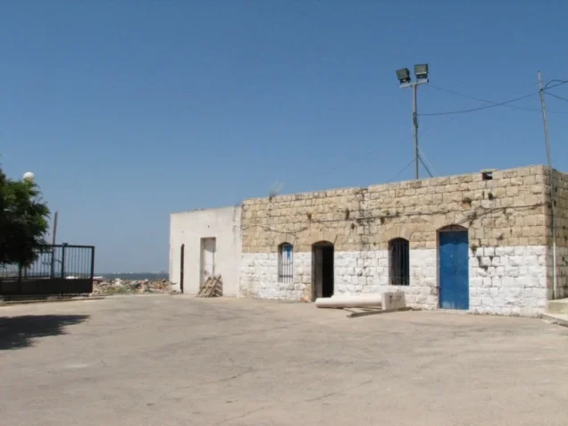

Photos from the village's people
Photos sent in by visitors and published after review.
Add a photo of this village
Log in to add photos of this village.
Other villages from Safed

More from the archive



 Download Our Palestine App
The whole archive in the palm of your hand: depopulated villages, the Nakba, the massacres and Al-Aqsa — free, with no ads to erase the story.
Download Our Palestine App
The whole archive in the palm of your hand: depopulated villages, the Nakba, the massacres and Al-Aqsa — free, with no ads to erase the story.



Comments
No comments yet — be the first to write one.
Add your comment
Name and email are optional. Comments appear after review.