
The depopulated village of Al-Sakhina / District of Baysan
Al-Sakhina
About the depopulated village of Al-Sakhina
- District
- Baysan
- Date Al-Sakhina was occupied
- 12 May 1948
- Population in 1948
- 615
- Military operation
- Operation Gideon
- Brigade that carried it out
- The village entry does not identify the occupying unit; Operation Gideon was carried out by the Haganah's Golani Brigade
- Distance from the governorate centre
- 5 km from Baysan
- Elevation above sea level
- -95 m
- Cause of displacement
- The Zionist offensive on the Baysan Valley in Operation Gideon, which PalQuest describes as the expulsion of the valley's inhabitants
- Extent of destruction
- al-Sakhina was completely destroyed and defaced.
- Ethnic cleansing
- al-Sakhina inhabitants were completely ethnically cleansed.
- Settlements built on the land of Al-Sakhina before 1948
- Nir David, established in 1936 under the name Tel Amal just south of the village site, on lands that traditionally belonged to al-Sakhina
Hover a dot to read the village name, or click to open its card.
Borders of the depopulated village of Al-Sakhina
Al-Sakhina – A Depopulated Palestinian Village in the Baysan Subdistrict
Al-Sakhina was a Palestinian village in the Baysan Subdistrict, located approximately 5 km west of the city of Baysan in the Baysan Valley, at an average elevation of about 95 meters below sea level.
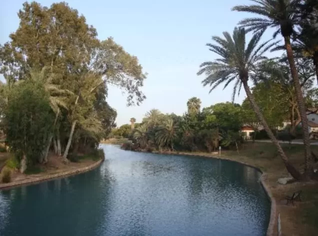
The village stood in the middle of a plain surrounded by several tells, while the Jalud River crossed its lands on its way toward the Jordan River. Numerous springs made the area particularly suitable for vegetables, orchards, fruit trees, and other irrigated agriculture.
The inhabitants were displaced during the Nakba and the occupation of Palestine in 1948 in the context of Operation Gideon, carried out by the Golani Brigade throughout the Baysan Valley from 10 to 15 May 1948. Walid Khalidi considers it probable that al-Sakhina fell around 12 May, but he does not present that date as a separately verified village-specific occupation date.
- Subdistrict
- Baysan
- Distance from Baysan
- 5 km from Baysan
- Elevation
- 95 m below sea level
- Population in 1931
- 374
- Number of Houses in 1931
- 78
- Arab population, 1944/45
- 530 – Arab population; the same statistical unit also recorded 290 Jews (total 820)
- Estimated Population in 1948
- About 615 – a later demographic estimate, not an official census
- Total statistical-unit population, 1944/45
- 820: 530 Arabs and 290 Jews
- Total land area
- 6,400 dunams – figure including the lands of the settlement of Nir David: 1,088 dunams Arab-owned, 4,985 Jewish-owned and 327 public
- Attack and Depopulation
- PalQuest lists al-Sakhina among the villages affected by Operation Gideon, carried out by the Haganah's Golani Brigade between 10 and 15 May 1948 to occupy the Baysan Valley and expel its inhabitants. Khalidi considers that the village may have fallen on 12 May 1948, the day on which two neighbouring villages were occupied and the town of Baysan was taken by the Golani Brigade.
- Final Israeli Control
- Probably 12 May 1948: according to Khalidi, al-Sakhina may have fallen on the day two neighbouring villages were occupied and the town of Baysan was taken; the sources give no confirmed day
- Probable occupation date
- Around 12 May 1948
- Military operation
- Operation Gideon
- Military unit
- The village entry does not identify the unit that occupied it; Operation Gideon was carried out by the Haganah's Golani Brigade, which took the town of Baysan on 12 May 1948
- Cause of Depopulation
- The Zionist offensive on the Baysan Valley in Operation Gideon, which PalQuest describes as the expulsion of the valley's inhabitants
- Settlements Documented on Village Lands
- Nir David, established in 1936 under the name Tel Amal just south of the village site, on lands that traditionally belonged to al-Sakhina; its settlers now cultivate the village lands
- Settlement established on village land before 1948
- Nir David, founded in 1936 as Tel Amal
Location and Geography of Al-Sakhina
Al-Sakhina stood in the middle of a plain bordered by three prominent tells: Tall al-Dahra al-Kabir to the north, Tall al-Dahra al-Saghir to the south, and Tall Amal, also to the south.
The al-Faqqu'a Mountains, also known as the Jilbu' or Gilboa Hills, extended south of the village. The Jalud River crossed al-Sakhina's lands on its way toward the Jordan River.
The main road to Baysan passed through the village, while a secondary road connected it with nearby al-Murassas.
Palestinian maps and local documentation place al-Murassas to the north, Qumya to the west, Khirbat al-Jawfa to the south, and Baysan to the east, with the al-Faqqu'a hills extending generally to the southwest.
Water and Springs
The al-Sakhina area was known for its abundance of springs. Khalidi notes the presence of numerous springs, which played a central role in the village's agricultural economy.
The Palestinian Encyclopedia identifies several local water sources, including 'Ayn al-Sakhina and 'Ayn al-'Asi to the east, 'Ayn Zahra to the northeast, and 'Ayn al-Jusq to the south.
The Jalud River was another major feature of the agricultural landscape, with vegetable and fruit cultivation concentrated along its banks.
Population of Al-Sakhina
The official 1931 Census of Palestine recorded 374 inhabitants in al-Sakhina living in 78 occupied houses.
The census recorded 372 Muslims, one Christian, and one Jew. The single Jewish resident should not be interpreted as evidence of a separate Jewish settlement within the Palestinian village at that date.
By 1944/45, the statistical unit also included Nir David. The official figures therefore recorded 530 Arabs and 290 Jews, for a total of 820 inhabitants.
The Palestinian population figure for al-Sakhina in 1944/45 was thus 530, not 820; the larger figure includes the Jewish population of Nir David.
Palestine Remembered later estimated the Palestinian population at 615 in 1948 and the number of refugees and their descendants at 3,776 in 1998. These are retrospective estimates rather than official British Mandate census counts.
- 1931374Official census; 372 Muslims, 1 Christian, and 1 Jew
- 1944/45530 ArabsOfficial statistics; the full statistical unit also included 290 Jews in Nir David, for a total of 820
- 1948615Later Palestine Remembered estimate of the Palestinian population, not an official census
- 19983,776 refugeesLater estimate of refugees and their descendants
Number of Houses
- 193178Occupied houses recorded in the official census
- 1948128Later estimate reported by Palestine Remembered
Clans and Local Community
Later Palestinian local documentation associates the inhabitants of al-Sakhina with the al-Qurut clan, al-Muqbil al-Zubaydi, and 'Arab al-Saqr. Khalidi's village entry does not provide a detailed tribal or genealogical breakdown, so these names are presented as local community documentation.
Land Ownership in Al-Sakhina
The 1944/45 statistical unit combining al-Sakhina and Nir David covered 6,400 dunums. Palestine Remembered presents the simplified ownership categories as follows:
- Palestinian1,088 dunums17%
- Transferred to Zionists4,985 dunums78%
- Communal/Public327 dunums5%
The official Village Statistics use the original categories Arab, Jewish, and Public: 1,088 dunums were classified as Arab, 4,985 as Jewish, and 327 as public land.
PalQuest explicitly notes that these statistics include Nir David. They should therefore be understood as figures for the wider statistical unit rather than a wholly separate cadastral table for the Palestinian village alone.
Land Use in 1944/45
- Arab
- Jewish
- Public
- Cereals1,471 dunums
- Plantations and irrigable land4,589 dunums
- Built-up land60 dunums
- Non-cultivable land280 dunums
Cultivable land totaled 6,060 dunums, approximately 95 percent of the statistical unit: 1,088 Arab dunums, 4,925 Jewish dunums, and 47 public dunums.
This corrects a simplified table that places 307 dunums of cereals under the Palestinian column. The detailed official breakdown is 260 Arab dunums and 47 public dunums.
Likewise, the 280 dunums of non-cultivable land were public land rather than privately Palestinian-owned land.
Economic Life
Agriculture formed the principal basis of life in al-Sakhina, supported by the abundance of springs and the waters of the Jalud River.
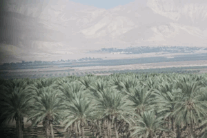
Villagers cultivated vegetables along the southern bank of the Jalud, as well as grapes and fruit trees, while date palms grew in the eastern lands.
In 1944/45, 260 Arab dunums were devoted to cereals and 828 Arab dunums to plantations and irrigable land.
A large forest occupied land northwest of the village, while cultivated areas were concentrated especially to the north and northwest and vegetable and fruit gardens extended along the Jalud River.
Education and Services
The principal sources used here do not provide sufficiently documented information about a formal school in al-Sakhina, its founding date, or pupil numbers. No unsupported educational data have therefore been added.
The same sources provide only limited detail on public facilities within the village, so the article restricts itself to well-documented roads, water resources, and agricultural activity.
Archaeological Sites
Several tells and archaeological localities stood around al-Sakhina, including Tall Tummas, Tall al-Dahra al-Kabir, and Tall al-Dahra al-Saghir.
Palestinian local sources describe ruins, foundations, columns, and paved surfaces at some of these sites.
Mandate-era gazetteers also record a place named Tall al-Sakhina, but the available principal sources do not provide enough information to establish a detailed archaeological chronology for every locality.
Operation Gideon
Operation Gideon began on 10 May 1948 and continued until 15 May. The Golani Brigade carried out the operation in order to seize the Baysan Valley and expel its Palestinian population.
PalQuest lists al-Sakhina among the villages affected by Operation Gideon, together with al-Ashrafiyya, al-Fatur, Khirbat al-Taqa, and Khirbat Umm Sabuna.
On 12 May, the town of Baysan fell to Golani forces, while two villages neighboring al-Sakhina were also occupied that day.
Occupation and Depopulation of Al-Sakhina
Khalidi does not provide a separately verified date for the military entry into al-Sakhina. He states that two neighboring villages were occupied on 12 May 1948 and that al-Sakhina may have fallen at about the same time, when Baysan itself was occupied during Operation Gideon.
For that reason, 12 May should be treated as the probable occupation date rather than an absolutely confirmed village-specific date.
Palestine Remembered presents 12 May directly as the occupation date and identifies Operation Gideon and the Golani Brigade. PalQuest's operation page confirms that al-Sakhina was affected by Operation Gideon, but the village-specific account does not name a battalion or sub-unit that physically entered the village.
- 1936
Settlement on village lands
The settlement of Nir David was established under the name Tel Amal just south of the village site, on lands that traditionally belonged to al-Sakhina.
- 10 May 1948
Beginning of the military operation
The Haganah's Golani Brigade began Operation Gideon to occupy the Baysan Valley and expel its inhabitants; it lasted until 15 May 1948, and PalQuest lists al-Sakhina among the villages affected by it.
- Probably 12 May 1948
Final occupation
Two neighbouring villages were occupied on 12 May 1948, the day on which the town of Baysan was taken by the Golani Brigade, and Khalidi considers that al-Sakhina may have fallen at the same time.
Nir David on the Lands of Al-Sakhina
Nir David was established in 1936 under the name Tel Amal, immediately south of al-Sakhina, on land traditionally belonging to the Palestinian village.
This explains why the 1944/45 population and land statistics combine al-Sakhina and Nir David in several tables and why the Jewish population and Jewish landholdings appear within the same statistical unit.
The principal sources do not identify a separate post-1948 settlement newly established directly on the former village site; instead, the site and surrounding lands became incorporated into agricultural and recreational uses connected with the Nir David area.
Al-Sakhina Today
According to Walid Khalidi's field description in All That Remains, no recognizable physical evidence of the Palestinian village remained. The entire site had been plowed and converted into agricultural fields, and the village lands were being cultivated by residents of Nir David.
This description derives from fieldwork conducted before the publication of All That Remains in 1992 and should not by itself be treated as direct field verification of conditions in 2026.
The Palestinian Encyclopedia states that part of the area was subsequently developed as a recreational site known as Gan HaShlosha and that a fish-breeding facility was established east of the former village site. Palestine Remembered also contains community photographs from 2002, 2005, and later years documenting the springs and pools and their use as a recreational area.
These later materials help document the post-Nakba transformation of the landscape, but they do not alter Khalidi's central observation that the built fabric of the Palestinian village itself had disappeared and no longer remained visibly identifiable.
Sources
- PalQuestPalQuest – Interactive Encyclopedia of the Palestine Question: al-Sakhina
- PalQuestPalQuest – Operation Gideon
- Palestine RememberedPalestine Remembered – al-Sakhina, Baysan
- Palestine RememberedPalestine Remembered – al-Sakhina entry from All That Remains
- Institute for Palestine StudiesInstitute for Palestine Studies – Walid Khalidi, All That Remains
- pcbs.gov.psGovernment of Palestine – Census of Palestine 1931
- maktabatsabil.comGovernment of Palestine – Village Statistics 1945: Beisan Sub-District, Population and Land Ownership
- maktabatsabil.comGovernment of Palestine – Village Statistics 1945: Beisan Sub-District, Cultivable Land
- palestinapedia.psPalestinian Encyclopedia – al-Sakhina
Photo gallery


Photos from the village's people
Photos sent in by visitors and published after review.
Add a photo of this village
Log in to add photos of this village.
Other villages from Baysan

More from the archive


 Download Our Palestine App
The whole archive in the palm of your hand: depopulated villages, the Nakba, the massacres and Al-Aqsa — free, with no ads to erase the story.
Download Our Palestine App
The whole archive in the palm of your hand: depopulated villages, the Nakba, the massacres and Al-Aqsa — free, with no ads to erase the story.



Comments
No comments yet — be the first to write one.
Add your comment
Name and email are optional. Comments appear after review.