
The depopulated village of Saris / District of Al-Quds (Jerusalem)
Subdistrict: Jerusalem
Estimated population of Saris in 1948: 650
Date of occupation and depopulation: Mid-April 1948, commonly dated to 16 April; sources also cite 13 April
Military operation: Operation Nachshon; some chronologies associate the 16 April attack with the opening of Operation Harel
Military force: A Haganah force reportedly comprising approximately 500 troops
Israeli settlements established on the lands of Saris before 1948: None
Israeli settlements established on the lands of Saris after 1948: Shoresh and Sho’eva
- Saris was situated approximately 15 kilometres west of Jerusalem.
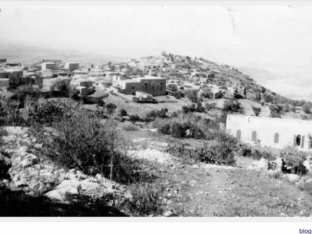
- The village stood on a high ridge extending from north to south. The ridge descended steeply at its northern end and overlooked the main Jerusalem–Jaffa road.
- Saris commanded extensive views in every direction, particularly toward the west, from where Ramla and Lydda could be seen with the naked eye.
Architectural Form of Saris
- In the late nineteenth century, Saris stood on the summit of a hill, with olive trees planted below it. The village had an arc-shaped plan that followed the contours of the site, and most of its houses were built of stone. Its residents were Muslims. A mosque and several shops stood at the village centre, while springs and wells supplied water for domestic use.
Boundaries of Saris
Saris was bordered by the following villages and towns:
- North: Bayt Thul.
- Northwest: Deir Ayyub.
- West: Bayt Mahsir.
- Southwest: Kasla.
- South: Bayt Umm al-Mays.
- Southeast: Deir Amr.
- East: Khirbat al-Umur.
- Northeast: Abu Ghosh, historically also known as Qaryat al-Inab.
Economic Life in Saris
The residents obtained water for domestic use from local springs and wells. Agriculture formed the principal basis of the village economy. According to the 1944/45 village statistics, 3,677 dunams of Palestinian-owned land were devoted to cereal cultivation, while 366 dunams were irrigated or used for orchards. Olive groves covered approximately 415 dunams.
Land Ownership in Saris, 1944/45
| Ownership category | Area (dunams)* |
|---|---|
| Palestinian ownership | 10,427 |
| Jewish ownership | 132 |
| Public land | 140 |
| Total | 10,699 |
* One dunam equals approximately 1,000 square metres.
Land Use in Saris, 1944/45
| Land-use category | Palestinian ownership (dunams)* | Jewish ownership (dunams)* | Public land (dunams)* | Total (dunams)* |
|---|---|---|---|---|
| Irrigated land and orchards | 366 | 0 | 0 | 366 |
| Olive groves** | 415 | 0 | 0 | 415 |
| Cereal cultivation | 3,677 | 123 | 30 | 3,830 |
| Built-up area | 10 | 0 | 0 | 10 |
| Cultivable land | 4,043 | 123 | 30 | 4,196 |
| Uncultivated land | 6,374 | 9 | 110 | 6,493 |
* One dunam equals approximately 1,000 square metres.
** The olive-grove figure is reported separately and should not be added to the cultivable-land total, because it may overlap with land classified as orchards.
Population of Saris
| Year | Population |
|---|---|
| 1596 | 292 |
| 1922 | 373 |
| 1931 | 470 |
| 1945 | 560 |
| 1948 | Approximately 650 |
| Estimated refugee population in 1998 | 3,989 |
The 1948 population and 1998 refugee figures are retrospective demographic estimates rather than contemporary official census counts.
Number of Houses in Saris
| Year | Number of houses |
|---|---|
| 1931 | 114 |
| 1948 | Approximately 157 |
The 1931 figure is an official census count; the 1948 figure is a later estimate.
Occupation and Depopulation of Saris
Saris was attacked and extensively demolished during the final phase of Operation Nachshon. Sources differ regarding the precise date: the History of the Haganah gives 13 April 1948, while other accounts place the principal attack on 16 April. Some Palestinian chronologies associate attacks on Saris beginning on 16 April with Operation Harel. The date should therefore be presented as disputed rather than as an uncontested fact.
Shortly before the attack, on 13 April, Haganah commander Israel Galili wrote to Jewish National Fund official Yosef Weitz requesting the establishment of a settlement at Saris “as soon as possible.” According to Benny Morris, Galili described settlement at Saris and seven other locations as important for security.
A Haganah force reportedly comprising approximately 500 troops attacked the village in the early morning with mortars and small arms. Contemporary reporting stated that the force remained for about five hours, demolished 25 buildings, and burned others before withdrawing. The village mosque and a school were also reported destroyed. Palestinian historian Arif al-Arif gave a higher figure of 35 demolished houses. Estimates therefore vary between sources.
Contemporary reporting recorded seven Palestinian fatalities and acknowledged the possibility that women were among the victims. Claims made at the time that Syrian troops were present in Saris have not been independently substantiated and are not treated here as established fact.
An official British dispatch later cited by Benny Morris suggested that the residents’ departure was influenced by news of the Deir Yasin massacre of 9 April. However, subsequent military developments indicate that Saris was not immediately or continuously held after its mid-April destruction. The Arab Liberation Army recorded renewed fighting in the Saris–Bayt Mahsir area on 9 May, suggesting that the village remained near the front line for several weeks.
Israeli Settlements Established on the Lands of Saris
Shoresh was established in 1948 approximately one kilometre southwest of the former village site. Sho’eva was established in 1950 approximately 500 metres northeast of it. Both settlements were built on land belonging to Saris rather than directly over the village’s former built-up centre.
Saris Today
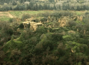
The former village site is covered with stone rubble, and iron reinforcement bars protrude from some collapsed roofs. Several open wells and caves with vaulted roofs remain visible. Cypress, fig, and almond trees grow across the site, while an abandoned almond grove lies on its eastern side.
The remains of an artificial pool are visible midway down the slope. The village cemetery, surrounded by trees, lies southwest of the site and contains several large graves. One grave stands within a small roofless enclosure, with an almond tree growing inside it.
Sources
- PalQuest, “Saris”.
- PalQuest, chronology of the Deir Yasin massacre and Operations Nachshon and Harel.
- Palestine Remembered, “Saris, Jerusalem Subdistrict”.
- Fawzi al-Qawuqji, “Memoirs, 1948, Part II,” Journal of Palestine Studies.
- Walid Khalidi (ed.), All That Remains: The Palestinian Villages Occupied and Depopulated by Israel in 1948, Institute for Palestine Studies, 1992.
- Government of Palestine, Village Statistics, April 1945.
- Government of Palestine, Census of Palestine, 1931.
- Benny Morris, The Birth of the Palestinian Refugee Problem, 1947–1949, consulted for the British dispatch concerning the residents’ displacement and the correspondence about establishing a settlement at Saris.
Photo gallery


Photos from the village's people
Photos sent in by visitors and published after review.
Add a photo of this village
Log in to add photos of this village.
Other villages from Al-Quds (Jerusalem)

 Download Our Palestine App
The whole archive in the palm of your hand: depopulated villages, the Nakba, the massacres and Al-Aqsa — free, with no ads to erase the story.
Download Our Palestine App
The whole archive in the palm of your hand: depopulated villages, the Nakba, the massacres and Al-Aqsa — free, with no ads to erase the story.



Comments
No comments yet — be the first to write one.
Add your comment
Name and email are optional. Comments appear after review.