
The depopulated village of Al-Maliha / District of Al-Quds (Jerusalem)
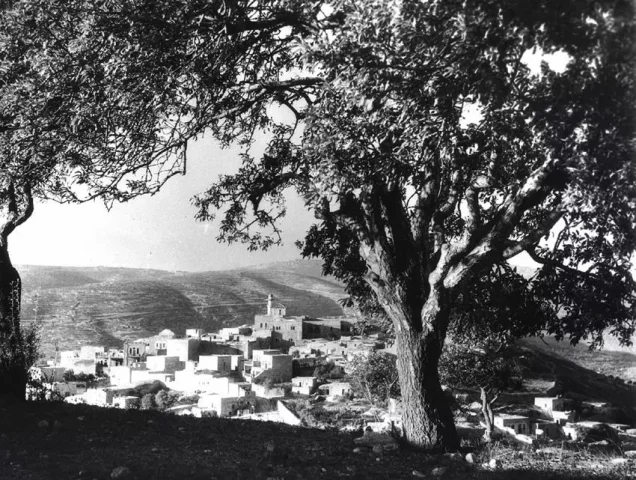
About the depopulated village of Al-Maliha
- District
- Al-Quds (Jerusalem)
- Date Al-Maliha was occupied
- 15 July 1948
- Population in 1948
- 2,250
- Military operation
- Operation Dani
- Brigade that carried it out
- Irgun Zvai Leumi (IZL or ETZEL) and Yonathan Company of the Gadna (Palmach Youth Battalions).
- Who defended the village
- Egyptian Muslim Brotherhoods operating south of Jerusalem alongside Palestinian guerrillas.
- Distance from the governorate centre
- 5.5 (km) West of Jerusalem
- Elevation above sea level
- 750 m
- Cause of displacement
- Military assault by Zionist troops
- Extent of destruction
- Many houses remain standing and occupied by Israeli Jewish settlers, although few houses, on the south side, were demolished
- Ethnic cleansing
- al-Maliha inhabitants were completely ethnically cleansed.
- Settlements built on the built-up area of Al-Maliha after 1948
- Manahat was established on the site in 1949. Later Jerusalem neighbourhoods developed on or around former village lands include Ramat Daniya, Ir Ganim, Givat Massua, parts of Gonen (the Katamonim), and Givat Mordechai.
Hover a dot to read the village name, or click to open its card.
Borders of the depopulated village of Al-Maliha
Al-Maliha was a Palestinian village situated southwest of Jerusalem. Its residents were displaced in 1948, and the village was gradually absorbed into the expanding urban area of Jerusalem. It stood approximately 5.5 kilometres from the city.
- Subdistrict
- Al-Quds (Jerusalem)
- Distance from district center
- 5.5 km West of Jerusalem
- Average Elevation
- 750 meters above sea level
- Population in 1931
- 1,410 inhabitants
- Population in 1944/1945
- 1,940 inhabitants
- Estimated Population in 1948
- Approximately 2,250 inhabitants - a later demographic estimate, not an official census
- Attack and Depopulation
- A report published by the Jaffa-based Palestinian newspaper Filastin dated the first recorded attack on al-Maliha to 6 March 1948, when a Jewish unit entered the village outskirts and clashed with its defenders. Israeli historian Benny Morris describes the evacuation as occurring in two stages.
- Final Israeli Control
- 15-16 July 1948
- Military Operation
- Dani
- Military Unit
- Irgun, backed by two platoons of the Gadna's Yonatan Company
- Cause of Depopulation
- Military assault by Zionist troops
- Settlements Documented on Village Lands
- Manahat was established on the site in 1949. Later Jerusalem neighbourhoods developed on or around former village lands include Ramat Daniya, Ir Ganim, Givat Massua, parts of Gonen (the Katamonim), and Givat Mordechai.
Information about al-Maliha
- Al-Maliha stood on a high mountain slope. Bayt Safafa and the Qatamon area lay to the east; Ayn Karim and al-Jura to the west; the lands of Lifta and Deir Yasin to the north; and the lands of Bayt Jala and Sharafat to the south.
- The village was approximately 5.5 kilometres southwest of Jerusalem.
- Al-Maliha stood on a plateau overlooking a wide area in every direction except the north. A newer section was constructed on the southeastern slope of a neighbouring hill. A short secondary road connected the village to the main road leading to Jerusalem, while other secondary roads and dirt tracks linked it with neighbouring villages.
- The village had a rectangular plan.
- Most houses were constructed of stone, and the population was predominantly Muslim. In 1945, the official total was 1,940 residents: 1,930 Muslims and 10 Christians.
Economic Life in al-Maliha
Most residents depended on rainfed agriculture and livestock raising, while others worked in crafts, commerce, and services. Village lands produced cereals, vegetables, and fruit. In 1944/45, 1,013 dunams of Palestinian-owned land were devoted to cereal cultivation, while 2,613 dunams were irrigated or used for orchards, including 1,370 dunams planted with olive trees. Wild vegetation covered the neighbouring mountain slopes, which were used for grazing.
Land Ownership in al-Maliha
- Palestinian ownership5,798 dunums85%
- Jewish ownership922 dunums14%
- Public land108 dunums2%
* One dunam equals approximately 1,000 square metres.
Land Use in al-Maliha, 1944/45
- Palestinian ownership (dunams)
- Jewish ownership (dunams)
- Public land (dunams)
- Irrigated land and orchards2,618 dunums
- Olive cultivation**1,370 dunums
- Cereal cultivation1,259 dunums
- Cultivable land3,877 dunums
- Built-up area328 dunums
- Uncultivated land2,623 dunums
- Total land area6,828 dunums
* One dunam equals approximately 1,000 square metres.
** Olive acreage is included within the broader plantation and irrigable category and must not be added again to the cultivable-land total.
Population Figures for al-Maliha
- 1596 estimate286
- 19221,038
- 19311,410
- 19451,940
- 1948 estimateApproximately 2,250
- Estimated refugees and descendants, 199813,820
* The 1922 and 1931 figures derive from British Mandate censuses, while the 1945 figure comes from the official Village Statistics. The 1948 and 1998 figures are later estimates. The 1931 figure includes Ayn Yalu.
Public Facilities in al-Maliha
Al-Maliha had the following public institutions:
- A government elementary school.
- A medical clinic.
- A large mosque named after Umar ibn al-Khattab, the second caliph.
- A small number of shops and a village council.
Archaeological Remains in al-Maliha
Numerous rock-cut tombs were found in and around the village, and a ruined tower stood near the mosque. These remains, together with other archaeological evidence at the site, indicate that the area had been inhabited since antiquity.
Occupation and Depopulation of al-Maliha
A report published by the Jaffa-based Palestinian newspaper Filastin dated the first recorded attack on al-Maliha to 6 March 1948, when a Jewish unit entered the village outskirts and clashed with its defenders. Israeli historian Benny Morris describes the evacuation as occurring in two stages. The first wave took place in April following the massacre in neighbouring Deir Yasin on 9 April.
Al-Maliha was not completely depopulated until mid-July, when it came under direct attack after the first truce. On the night of 13–14 July, a company of the Irgun Zvai Leumi and two platoons of the Gadna's Yonatan Company entered the village and established positions there. Arab forces counterattacked on 15 July and temporarily forced the Irgun to withdraw from its most advanced position, but Israeli reinforcements retook it. Further fighting continued on 16 July, after which al-Maliha remained under Israeli control. Sources commonly use 14 July as the occupation and depopulation date, although the battle extended over several days.
Occupation and Depopulation Chronology
- 15-16 July 1948
Occupation and Depopulation of al-Maliha
A report published by the Jaffa-based Palestinian newspaper Filastin dated the first recorded attack on al-Maliha to 6 March 1948, when a Jewish unit entered the village outskirts and clashed with its defenders. Al-Maliha was not completely depopulated until mid-July, when it came under direct attack after the first truce.
Israeli Development on al-Maliha's Lands
The Israeli suburb of Manahat was established on the village site in 1949. The site was later incorporated into Jerusalem's expanding southern and southwestern urban area. PalQuest specifically notes that parts of the Ramat Daniya neighbourhood surround the village on the west and north. Other Palestinian compilations also attribute areas occupied by Ir Ganim, Givat Massua, Gonen, and Givat Mordechai to al-Maliha's former lands; exact boundary attributions vary between sources.
Al-Maliha Today
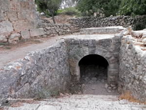
Many of the village houses remain standing and are occupied by Jewish families, although several houses in the southern part of the village were demolished. The inhabited limestone houses are generally two-storey structures with arched doors and windows; some have balconies whose roofs are supported by columns and rounded arches. The mosque and its tall, round minaret remain in the village centre, while the former school building has been abandoned. The village cemetery survives on the southern edge of the site, and orchards grow on the southern and southeastern slopes and in the valleys.
Sources
Photo gallery


Photos from the village's people
Photos sent in by visitors and published after review.
Add a photo of this village
Log in to add photos of this village.
Other villages from Al-Quds (Jerusalem)

More from the archive


 Download Our Palestine App
The whole archive in the palm of your hand: depopulated villages, the Nakba, the massacres and Al-Aqsa — free, with no ads to erase the story.
Download Our Palestine App
The whole archive in the palm of your hand: depopulated villages, the Nakba, the massacres and Al-Aqsa — free, with no ads to erase the story.




Comments
No comments yet — be the first to write one.
Add your comment
Name and email are optional. Comments appear after review.