
The depopulated village of Al-Walaja / District of Al-Quds (Jerusalem)
Subdistrict: Jerusalem
Estimated population of al-Walaja in 1948: approximately 1,910
Date of the 1948 attack and initial occupation: 21 October 1948
Military unit: Eighth Battalion of the Etzioni Brigade
Operation: Operation Ha-Har
Israeli settlements established on the village lands before 1948: None
Israeli settlements established on the village lands after 1948: Aminadav
Village land located west of the 1949 Armistice Line: Sources commonly state that approximately 70 per cent of al-Walaja’s original lands—about 12,396 of its 17,708 dunams—fell under Israeli control. The figure of 13,445 dunams appears in some local compilations, but estimates vary between sources.
Al-Walaja
Al-Walaja was a Palestinian village in the Jerusalem Subdistrict, located approximately 8.5 kilometres west-southwest of Jerusalem. The Jerusalem–Jaffa railway passed along the southern edge of its lands, while a secondary paved road connected the village with the road leading to Jerusalem.
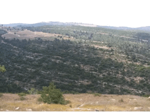
The village stood on a large hill on the slope of one of the ancient mountain formations of the Jerusalem highlands. It overlooked Wadi al-Sarar, through which the railway ran. The name al-Walaja, meaning an opening or passage, probably referred to the natural gap in the mountain chain through which transport routes passed.
Boundaries of Al-Walaja
Al-Walaja was surrounded by the following Palestinian villages and localities:
- North: Ayn Karim.
- Northwest: Sataf.
- West: Battir.
- Southwest: Al-Qabu.
- South: Al-Khadr.
- Southeast: the section of al-Walaja that remained east of the 1949 Armistice Line, where displaced villagers subsequently rebuilt their community.
- East: Sharafat.
- Northeast: Al-Maliha.
Architectural Structure of Al-Walaja
The village houses were built of stone, adobe, and cement. They were closely clustered and separated by narrow, winding lanes. Towards the end of the British Mandate, al-Walaja expanded considerably, with new houses constructed northeast and southeast of the historic village centre.
Al-Walaja contained several shops, an elementary school, and a mosque known as Masjid al-Arba'in, or the Mosque of the Forty. Local accounts describe more than 350 houses in the village by the late Mandate period, although the official 1931 census recorded 202 inhabited houses.
The quarries near the village supplied the distinctive building stone widely used in the Jerusalem region.
Land of Al-Walaja
The village possessed a total of 17,708 dunams. Of this area, 17,507 dunams were under Palestinian ownership, 35 dunams under Jewish ownership, and 166 dunams were classified as public land.
Al-Walaja’s agricultural lands included mountain slopes, terraces, valleys, and comparatively level areas. Cereals were generally cultivated on flatter land, while fruit trees, vines, and olive trees were planted on the slopes. Olive cultivation was among the village’s most important agricultural activities.
Land Ownership in Al-Walaja, 1944/45
| Ownership category | Area (dunams)* |
|---|---|
| Palestinian ownership | 17,507 |
| Jewish ownership | 35 |
| Public land | 166 |
| Total | 17,708 |
* One dunam equals approximately 1,000 square metres.
Land Use in Al-Walaja, 1944/45
| Land-use category | Palestinian land (dunams)* | Jewish-owned land (dunams)* | Public land (dunams)* | Total (dunams)* |
|---|---|---|---|---|
| Irrigated land and orchards | 2,136 | 0 | 0 | 2,136 |
| Olive groves (included within orchards) | 80 | 0 | 0 | 80 |
| Cereal cultivation | 6,205 | 22 | 0 | 6,227 |
| Built-up area | 31 | 0 | 0 | 31 |
| Cultivable land | 8,341 | 22 | 0 | 8,363 |
| Uncultivated land | 9,135 | 13 | 166 | 9,314 |
* One dunam equals approximately 1,000 square metres. The olive-grove figure is included within the orchard category and should not be added separately when calculating cultivable land.
Population of Al-Walaja
The population increased from 910 in the British census of 1922 to 1,206 in 1931. The official 1945 statistics recorded 1,650 inhabitants, all Palestinian Muslims. A later demographic projection estimated that the population had reached approximately 1,914 by 1948.
Following their displacement during the Nakba, many villagers sought refuge in the Bethlehem and Jerusalem areas. Significant communities of displaced people from al-Walaja and their descendants came to reside in Dheisheh and Shu'fat refugee camps, while some families rebuilt the village on the portion of its lands that remained east of the 1949 Armistice Line.
Population of Al-Walaja by Year
| Year | Population* |
|---|---|
| 1596 | Approximately 655 |
| 1922 | 910 |
| 1931 | 1,206 |
| 1945 | 1,650 |
| 1948 estimate | 1,914 |
| Estimated refugees and descendants in 1998 | 11,754 |
* The 1948 and 1998 figures are later demographic estimates rather than contemporaneous census counts.
Number of Houses in Al-Walaja
| Year | Number of houses |
|---|---|
| 1931 | 202 |
| Late Mandate period | Local accounts describe more than 350 houses |
| 1948 estimate | 320; estimates vary between sources |
Education and Religious Life in Al-Walaja
Al-Walaja had an old mosque known as Masjid al-Arba'in, where congregational Friday prayers and the prayers of the two annual Islamic festivals were held. Local documentary traditions refer to the presence of an imam in the village as early as 1538.
Before the establishment of a formal elementary school during the British Mandate, instruction was provided through the kuttab system, commonly based in or associated with the mosque. Children were taught reading, writing, and religious studies. Local accounts indicate that literacy was relatively widespread among some older residents during the Mandate period. The village later maintained an elementary school for boys.
Economic Life in Al-Walaja
Agriculture formed the foundation of the village economy. Numerous wells and springs were distributed across the village lands, particularly in the southern areas. These water sources irrigated much of the cultivated land, although rainfed agriculture was also practised.
Cereals were cultivated mainly on relatively level ground, while fruit trees, vineyards, and olive trees grew on the terraced slopes. Olives were among the village’s principal products. In 1944/45, 6,205 dunams of Palestinian-owned land were devoted to cereals, while 2,136 dunams were irrigated or used for orchards. Quarries near the village also supplied building stone to the Jerusalem region.
Archaeological and Natural Landmarks in Al-Walaja
The village and its surrounding lands contain archaeological remains associated with several historical periods. Remains near the springs include ancient structures and water installations, some of which have been identified as belonging to the Roman or Byzantine periods.
Al-Walaja is also known for the ancient al-Badawi olive tree. It is frequently described in Palestinian local accounts as being several thousand years old and as one of the oldest olive trees in the world. Scientific and popular estimates of its precise age vary, however, and should not be presented as a conclusively established date.
Occupation and Depopulation of Al-Walaja
On the night of 21 October 1948, the Eighth Battalion of the Etzioni Brigade attacked al-Walaja during Operation Ha-Har. The offensive formed part of a broader attempt to expand Israeli control southwest of Jerusalem during Israel’s occupation of Palestine—the Nakba.
The initial occupation was not permanent. Palestinian fighters and Egyptian irregular forces operating in the area mounted counterattacks that compelled the attacking forces to withdraw. Most of the village site and approximately 70 per cent of its lands were subsequently placed on the Israeli-controlled side of the 1949 Armistice Line under the armistice arrangements concluded with Jordan on 3 April 1949. Israeli forces entered the old village site in the weeks following the agreement.
Most residents were displaced, but approximately one hundred villagers resettled on the southeastern portion of al-Walaja’s lands that remained east of the Armistice Line. There they established what became known as al-Walaja al-Jadida, or New al-Walaja. UNRWA subsequently constructed refugee shelters and an elementary school on that part of the village lands.
Israeli Settlements on the Lands of Al-Walaja
The Israeli settlement of Aminadav was established on land belonging to al-Walaja in 1950.
Al-Walaja Today
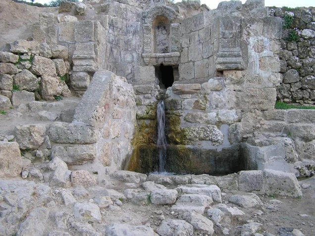
A small number of stone houses remain standing at the original village original village site. Most of the site is covered with stone rubble, while almond trees grow on the western terraces and to the north. A spring in the valley west of the site continues to flow from a stone-and-concrete structure.
The 1949 Armistice Line divided the southern lands of al-Walaja. The surviving Palestinian community rebuilt the village east of this line, while the old village site and most of its original lands remained under Israeli control.
Sources
- Interactive Encyclopedia of the Palestine Question – Al-Walaja.
- Institute for Palestine Studies – In the Seam Zone: Walaja’s Fate between Jerusalem and Bethlehem.
- Jerusalem Story – Al-Walaja: An Ancient Palestinian Village Fragmented by Settlements and the Separation Wall.
- Palestine Open Maps – Al-Walaja.
- Palestine Remembered – Al-Walaja.
- Walid Khalidi, ed., All That Remains: The Palestinian Villages Occupied and Depopulated by Israel in 1948, Institute for Palestine Studies, pp. 322–323.
- Government of Palestine, Census of Palestine, 1922; Census of Palestine, 1931; and Village Statistics, April 1945.
Photo gallery


Photos from the village's people
Photos sent in by visitors and published after review.
Add a photo of this village
Log in to add photos of this village.
Other villages from Al-Quds (Jerusalem)
 Download Our Palestine App
The whole archive in the palm of your hand: depopulated villages, the Nakba, the massacres and Al-Aqsa — free, with no ads to erase the story.
Download Our Palestine App
The whole archive in the palm of your hand: depopulated villages, the Nakba, the massacres and Al-Aqsa — free, with no ads to erase the story.



Comments
No comments yet — be the first to write one.
Add your comment
Name and email are optional. Comments appear after review.