
The depopulated village of Ras Abu 'Ammar / District of Al-Quds (Jerusalem)

Ras Abu 'Ammar
About the depopulated village of Ras Abu 'Ammar
- District
- Al-Quds (Jerusalem)
- Date Ras Abu 'Ammar was occupied
- 21 October 1948
- Population in 1948
- 719
- Military operation
- Operation Ha-Har
- Brigade that carried it out
- Probably units of the Harel Brigade, according to Khalidi
- Distance from the governorate centre
- 14 km west of Jerusalem
- Elevation above sea level
- 625 m
- Cause of displacement
- Direct military assault by Israeli occupation forces, according to Benny Morris as cited by Khalidi
- Extent of destruction
- Ras Abu 'Ammar was mostly destroyed and defaced.
- Ethnic cleansing
- Ras Abu 'Ammar inhabitants were completely ethnically cleansed.
- Settlements built on the built-up area of Ras Abu 'Ammar after 1948
- Tzur Hadassa, established in 1960 on village lands south of the village site
Hover a dot to read the village name, or click to open its card.
Borders of the depopulated village of Ras Abu 'Ammar
Ras Abu 'Ammar – A Depopulated Palestinian Village in the Jerusalem Subdistrict
Ras Abu 'Ammar was a Palestinian village in the Jerusalem Subdistrict, located approximately 14 km west of Jerusalem on a mountain ridge at an average elevation of about 625 meters above sea level.
The village was surrounded on three sides by Wadi al-Sarar and stood less than one kilometer south of the Jerusalem–Jaffa railway. It formed part of the western Jerusalem hill country traditionally known as the 'Arqub region.
Ras Abu 'Ammar was occupied during the Nakba and the occupation of Palestine in 1948. Walid Khalidi considers it probable that the village fell to the Israeli Har'el Brigade during Operation ha-Har, while Israeli historian Benny Morris dates its occupation to 21 October 1948 and attributes its depopulation to direct military assault.
- Subdistrict
- Jerusalem
- Distance from Jerusalem
- 14 km west of Jerusalem
- Average elevation
- 625 m above sea level
- Population in 1931
- 488 – joint figure including 'Ayn Hubin and 'Aqqur, not the village alone
- Number of Houses in 1931
- 106 – joint figure including 'Ayn Hubin and 'Aqqur, not the village alone
- Physical setting
- Mountain ridge surrounded on three sides by Wadi al-Sarar
- Population, 1944/45
- 620
- Estimated Population in 1948
- About 719 – a later demographic estimate, not an official census
- Total land area
- 8,342 dunams
- Attack and Depopulation
- Khalidi considers it probable that the village fell to units of the Harel Brigade in the course of Operation Ha-Har; Israeli historian Benny Morris indicates that it was occupied on 21 October 1948 as a result of a direct military assault on it.
- Final Israeli Control
- 21 October 1948, according to Benny Morris as cited by Khalidi
- Date of occupation
- 21 October 1948
- Military operation
- Operation Ha-Har, probably, according to Khalidi
- Military unit
- Probably units of the Harel Brigade, according to Khalidi
- Cause of depopulation
- Direct military assault by Israeli occupation forces, according to Benny Morris as cited by Khalidi
- Settlements Documented on Village Lands
- Tzur Hadassa, established in 1960 on village lands south of the village site
- Israeli settlement on village land
- Tzur Hadassa, established in 1960
Location and Geography of Ras Abu 'Ammar
Ras Abu 'Ammar stood on an elongated hill extending from southeast to northwest. The deep Wadi al-Sarar surrounded the village on three sides before winding westward, while the mountains of the Jerusalem hill country dominated the surrounding landscape.
The village stood less than one kilometer south of the Jerusalem–Jaffa railway. A secondary road connected it with a main road to the south leading toward Bethlehem.
In the late nineteenth century, Ras Abu 'Ammar was described as a stone-built village on a small ridge overlooking an open and relatively flat valley in which villagers cultivated olive trees.
Neighboring Villages
Palestinian maps and local sources place Ras Abu 'Ammar among a group of villages in the 'Arqub region and the western Jerusalem hills. Their approximate positions were:
- North: 'Aqqur.
- Northwest: Dayr al-Shaykh.
- West: Bayt 'Itab.
- Southwest: 'Allar.
- South: Wadi Fukin.
- Southeast: al-Qabu.
- East: al-Walaja.
- Northeast: Bayt Saqiya.
These directions describe approximate geographical relationships and should not be treated as substitutes for detailed cadastral boundaries.
Name of Ras Abu 'Ammar
The villagers maintained several shrines dedicated to local holy men, including a shrine for Shaykh Abu 'Ammar.
Local historical tradition associates the village name with Shaykh Abu 'Ammar and his shrine. The principal sources do not provide independent documentary evidence establishing the origin of the name beyond doubt, so this is best presented as the principal local explanation.
Built Form of the Village
Ras Abu 'Ammar had a rectangular plan and most of its houses were constructed of stone. A main street running northwest to southeast divided the village into two sections.
During the British Mandate, new buildings appeared along the roads leading east and north toward al-Qabu and 'Aqqur and along the main highway south of the village.
An elementary school and several small shops stood near the center of the village, alongside a number of local religious shrines.
Population of Ras Abu 'Ammar
The official 1922 Census of Palestine recorded 339 inhabitants in Ras Abu 'Ammar, all Muslims.
The 1931 figure requires particular caution. The official census recorded 488 inhabitants living in 106 occupied houses, but this was a combined statistical unit comprising Ras Abu 'Ammar, 'Aqqur, and 'Ayn Hubin. Neither the population nor the housing figure can therefore be treated as a standalone count for Ras Abu 'Ammar.
In the 1944/45 Village Statistics, Ras Abu 'Ammar was separately recorded with a population of 620 Arabs, all Muslims.
Palestine Remembered later estimated the population at 719 in 1948 and the number of refugees and their descendants at 4,417 in 1998. These are retrospective estimates rather than official British Mandate census counts.
- 1922339Official census; all Muslims
- 1931488Official combined count for Ras Abu 'Ammar, 'Aqqur, and 'Ayn Hubin; not Ras Abu 'Ammar alone
- 1944/45620Official separate figure for Ras Abu 'Ammar
- 1948719Later demographic estimate, not an official Mandate census
- 19984,417 refugeesLater estimate of refugees and their descendants
Number of Houses
- 1931106Combined figure for Ras Abu 'Ammar, 'Aqqur, and 'Ayn Hubin, not the village alone
The principal sources used here do not provide a secure standalone housing count for Ras Abu 'Ammar in 1931 or a sufficiently documented 1948 house estimate. No additional figure has therefore been derived from the population.
Education in Ras Abu 'Ammar
Ras Abu 'Ammar had an elementary school. Sources from neighboring villages also indicate that some pupils from Dayr al-Shaykh attended school in Ras Abu 'Ammar to continue their education.
Khalidi and PalQuest do not provide a documented founding date or pupil enrollment total, so unsupported educational figures have not been added.
The school later became one of the few structures recorded as surviving the destruction of the village. Khalidi described it as a two-storey stone building standing southeast of the former village site.
Land Ownership in Ras Abu 'Ammar
The total area of Ras Abu 'Ammar in the 1944/45 Village Statistics was 8,342 dunums.
Palestine Remembered presents the simplified ownership categories as follows:
- Palestinian8,313 dunums100%
- Transferred to Zionists0 dunums0%
- Communal/Public29 dunums<1%
The official Village Statistics use the original categories Arab and Public: 8,313 dunums were classified as Arab land and 29 dunums as public land. No land was recorded under the Jewish category.
Land Use in 1944/45
- Arab
- Public
- Cereals2,791 dunums
- Plantations and irrigable land925 dunums
- Built-up land40 dunums
- Non-cultivable land4,586 dunums
Cultivable land totaled 3,716 dunums, approximately 45 percent of the village area, while built-up and non-cultivable land totaled 4,626 dunums.
Approximately 100 dunums were planted with olive trees. This is a crop-specific figure within the cultivated land and should not be added again to the 925 dunums of plantations and irrigable land.
Economic Life
Agriculture and livestock raising formed the basis of life in Ras Abu 'Ammar. Farming combined rain-fed cultivation with irrigation from local springs.
Villagers grew cereals, vegetables, fruit trees, olives, and grapevines. In 1944/45, 2,791 dunums were devoted to cereals and 925 dunums to plantations and irrigable land.
Olive trees covered approximately 100 dunums, while grapevines and other irrigated crops benefited from spring water.
Water and Springs
The inhabitants relied on local springs for drinking water and irrigation. Water descending from the higher slopes was collected in ponds and used to irrigate vegetable gardens, orchards, and grapevines.
Local Palestinian documentation preserves names such as 'Ayn al-Wahsh and 'Ayn al-Mizrab. These names belong to local geographical memory, while Khalidi's principal entry more generally confirms reliance on springs without providing a complete list.
Religious Shrines
The Muslim inhabitants maintained several shrines associated with local holy men. The best known was the shrine of Shaykh Abu 'Ammar.
The village's name is locally associated with this figure, although the principal sources do not provide sufficient historical evidence to reconstruct the history of the shrine or the life of the shaykh in greater detail.
Archaeological Remains
Nearby Khirbat Kafr Sum was inhabited during the Crusader period and was also occupied in the sixteenth century, according to Khalidi's village entry.
The principal sources do not provide a detailed archaeological survey of Ras Abu 'Ammar itself, so no broader archaeological chronology has been asserted.
Operation ha-Har
Operation ha-Har was launched on 19 October 1948 and continued until 24 October, following the end of the second truce.
The offensive sought to widen Israeli-controlled territory in the Jerusalem corridor and advance southward toward the Hebron hills, linking occupied areas in the corridor with territory seized in the southern theater.
The Har'el and Etzioni brigades formed the principal forces of the offensive, alongside other forces operating in connected sectors.
PalQuest's general Operation ha-Har page does not explicitly list Ras Abu 'Ammar among its affected villages. The village-specific PalQuest/Khalidi entry, however, directly considers it probable that Ras Abu 'Ammar fell to the Har'el Brigade during this operation. The attribution should therefore remain qualified rather than presented as absolute certainty.
Occupation and Depopulation of Ras Abu 'Ammar
Khalidi states that Ras Abu 'Ammar probably fell to units of the Israeli occupation forces' Har'el Brigade in the course of Operation ha-Har.
Citing Israeli historian Benny Morris, he gives 21 October 1948 as the date on which the village was occupied as a result of direct military assault.
This date is also used in Palestinian Central Bureau of Statistics tables of Jerusalem localities depopulated in 1948, which list Ras Abu 'Ammar with an estimated population of 719 and a displacement date of 21 October 1948.
The village-specific account does not identify a particular Har'el battalion as the force that entered Ras Abu 'Ammar. It would therefore be inaccurate to assign the village to the Fourth or Sixth Battalion solely because those units occupied other villages during Operation ha-Har.
- Night of 18–19 October 1948
Beginning of the military operation
Operation Ha-Har, launched by the Harel and Etzioni brigades after the second truce to widen the corridor to Jerusalem and link it with the Hebron hills, began with an attack on Egyptian forces just west of Dayr Aban. Khalidi considers it probable that Ras Abu 'Ammar fell in the course of this operation, although PalQuest does not include it in the operation's list of affected villages.
- 21 October 1948
Final occupation
The village was occupied as a result of a direct military assault on it, according to Israeli historian Benny Morris as cited by Khalidi, who considers it probable that it fell to units of the Harel Brigade.
- 24 October 1948
End of Operation Ha-Har
Operation Ha-Har, which lasted from 19 to 24 October, came to an end; during it the Egyptian army was forced to retreat to the west and Israeli occupation forces captured several villages southwest of Jerusalem.
- 1960
Settlement on village lands
Israel established the settlement of Tzur Hadassa on village lands, south of the village site.
Israeli Settlements on the Lands of Ras Abu 'Ammar
Tzur Hadassa: Established in 1960 on land belonging to Ras Abu 'Ammar, south of the former village site.
Khalidi does not identify any Israeli settlement as having been established on Ras Abu 'Ammar's lands before the Nakba.
Ras Abu 'Ammar Today
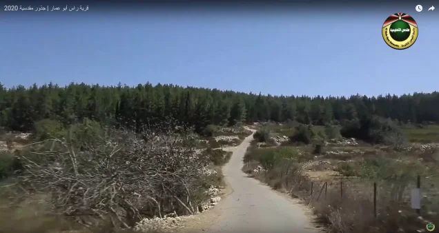
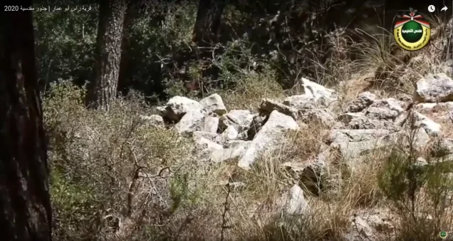
According to Walid Khalidi's field description in All That Remains, stone rubble from the destroyed houses was scattered across the village site.
Wild vegetation grew among the debris, together with almond, olive, and carob trees, while cactus grew on the southeastern and southwestern sides of the site.
The most prominent surviving structure recorded by Khalidi was the two-storey stone school building standing southeast of the former village.
This description derives from fieldwork conducted before the publication of All That Remains in 1992 and should not be treated as direct verification of every feature at the site in 2026.
Palestine Remembered contains later community documentation, including a recorded walk through the village lands in 2017, a “Jerusalem Roots” visit in 2020, and additional material uploaded in 2026. These materials document continued visits to the site but do not constitute a comprehensive independent architectural or archaeological field survey capable of confirming the present condition of every surviving structure.
Sources
- PalQuestPalQuest – Interactive Encyclopedia of the Palestine Question: Ras Abu 'Ammar
- PalQuestPalQuest – Operation ha-Har
- Palestine RememberedPalestine Remembered – Ras Abu 'Ammar, Jerusalem
- Palestine RememberedPalestine Remembered – Ras Abu 'Ammar entry from All That Remains
- Institute for Palestine StudiesInstitute for Palestine Studies – Walid Khalidi, All That Remains
- pcbs.gov.psGovernment of Palestine – Census of Palestine 1922
- pcbs.gov.psGovernment of Palestine – Census of Palestine 1931
- maktabatsabil.comGovernment of Palestine – Village Statistics 1945: Jerusalem Sub-District, Population and Land Ownership
- sabil.meGovernment of Palestine – Village Statistics 1945: Jerusalem Sub-District, Cultivable Land
- maktabatsabil.comGovernment of Palestine – Village Statistics 1945: Jerusalem Sub-District, Built-up and Non-Cultivable Land
Photo gallery






Photos from the village's people
Photos sent in by visitors and published after review.
Add a photo of this village
Log in to add photos of this village.
Other villages from Al-Quds (Jerusalem)

More from the archive
 Al-Quds (Jerusalem)
The depopulated village of Khirbat al-Tannur - Allar al-Sifla / District of Al-Quds (Jerusalem)
 Al-Quds (Jerusalem)
The depopulated village of al-Burayj (Bayarat Burayj) / District of Al-Quds (Jerusalem)
 Al-Quds (Jerusalem)
The depopulated village of Sufla / District of Al-Quds (Jerusalem)
 Download Our Palestine App
The whole archive in the palm of your hand: depopulated villages, the Nakba, the massacres and Al-Aqsa — free, with no ads to erase the story.
Download Our Palestine App
The whole archive in the palm of your hand: depopulated villages, the Nakba, the massacres and Al-Aqsa — free, with no ads to erase the story.



Comments
No comments yet — be the first to write one.
Add your comment
Name and email are optional. Comments appear after review.