
The depopulated village of Dayr Sunayd / District of Gaza
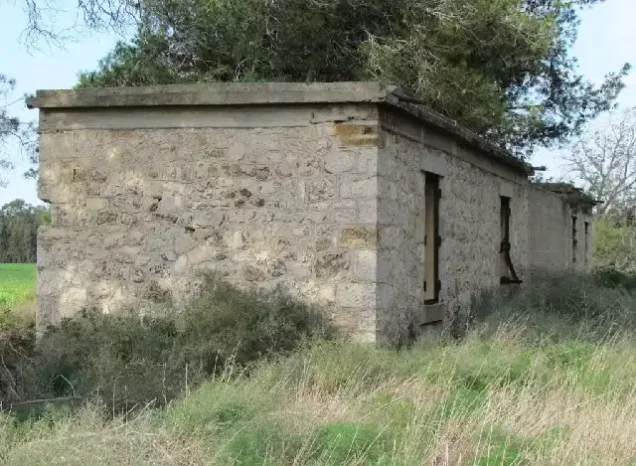
Dayr Sunayd
About the depopulated village of Dayr Sunayd
- District
- Gaza
- Date Dayr Sunayd was occupied
- 30 October 1948
- Population in 1948
- 847
- Military operation
- Operation Yoav
- Brigade that carried it out
- The available sources do not identify the unit that occupied the village
- Who defended the village
- Egyptian Army
- Distance from the governorate centre
- 12 km northeast of Gaza
- Elevation above sea level
- 50 m
- Cause of displacement
- Aerial bombardment followed by the advance of Israeli occupation forces along the coastal road in Operation Yoav; the available sources do not detail how the inhabitants left
- Extent of destruction
- The village was mostly destroyed with the exception of the train station's buildings.
- Ethnic cleansing
- Dayr Sunayd inhabitants were completely ethnically cleansed.
- Settlements built on the built-up area of Dayr Sunayd after 1948
- No Israeli settlements on village lands, according to Khalidi; the settlement of Yad Mordekhay (1943) lies just to the north of village lands
Hover a dot to read the village name, or click to open its card.
Borders of the depopulated village of Dayr Sunayd
Dayr Sunayd: A Depopulated Palestinian Village in the Gaza District
Dayr Sunayd was a depopulated Palestinian village in the Gaza District, located approximately 12 kilometers northeast of Gaza City on Palestine's coastal plain, at an average elevation of about 50 meters above sea level. Its lands extended between Wadi al-'Abd to the north and Wadi al-Hasi to the south.
- Subdistrict
- Gaza
- Distance from district center
- 12 km northeast of Gaza
- Average Elevation
- 50 m above sea level
- Population in 1931
- 475
- Number of Houses in 1931
- 103
- Population in 1944/1945
- 730
- Estimated Population in 1948
- About 847 – a later demographic estimate, not an official census
- Total Land Area in 1945
- 6,081 dunams
- Attack and Depopulation
- The village was bombed from the air at the beginning of Operation Yoav on 15–16 October 1948, according to Morris as cited by Khalidi, and was 'pummeled' again on 21 October, according to the New York Times. Israeli occupation forces probably captured it in late October or early November 1948, when they advanced along the coastal road after the withdrawal of Egyptian forces.
- Final Israeli Control
- Probably late October or early November 1948; Khalidi states that the date of occupation cannot be specified with certainty, and al-Majdal, the city to the north, was occupied on 4 November 1948
- Military Operation
- Operation Yoav
- Military Unit
- The available sources do not identify the unit that occupied the village
- Cause of Depopulation
- Aerial bombardment followed by the advance of Israeli occupation forces along the coastal road in Operation Yoav; the available sources do not detail how the inhabitants left
- Settlements Documented on Village Lands
- No Israeli settlements on village lands, according to Khalidi; the settlement of Yad Mordekhay (1943) lies just to the north of village lands
The village occupied an important position beside the coastal highway and had a station on the coastal railway line, providing convenient connections with Gaza to the south and al-Majdal to the north. During the Nakba and the occupation of Palestine in 1948, Dayr Sunayd was bombed and later occupied by Israeli forces in the course of Operation Yoav. Its Palestinian inhabitants were displaced, and most of the village was subsequently destroyed.
Location of Dayr Sunayd
- Dayr Sunayd was located approximately 12 kilometers northeast of Gaza.
- Its average elevation was about 50 meters above sea level.
- The village stood on Palestine's coastal plain, not far from the Mediterranean coast, between Wadi al-'Abd to the north and Wadi al-Hasi to the south.
- It was situated beside the main coastal highway and had a station on the coastal railway line.
- Its location provided convenient access to Gaza in the south, al-Majdal in the north, and neighboring Palestinian villages.
Origin of the Name Dayr Sunayd
The first part of the village name, “Dayr,” meaning monastery in Arabic, suggests that Christian monks may have lived at the site at some earlier period, although this does not necessarily indicate the presence of a settled Christian community there in later times. “Sunayd” was the name of an Arab tribe.
Dayr Sunayd During the Ottoman Period
In 1596, Dayr Sunayd was a village in the nahiya of Gaza within the liwa' of Gaza. According to Ottoman records cited by Walid Khalidi, it had an estimated population of 66. The inhabitants paid taxes on agricultural products including wheat, barley, and fruit, as well as goats and beehives.
The Built Environment of Dayr Sunayd
In the late nineteenth century, Dayr Sunayd was a medium-sized rectangular village divided into four quarters by two roads intersecting at right angles. Its houses were built of adobe brick, and the village contained wells, gardens, a pond, and a mosque at its center.
By the end of the British Mandate period, construction had expanded westward toward the main coastal highway. According to the 1944/1945 statistics, the built-up area covered approximately 13 dunums.
Population of Dayr Sunayd
Dayr Sunayd had 356 inhabitants in the 1922 census. The population increased to 475 in the 1931 census, when 103 houses were recorded. The Government of Palestine's 1944/1945 statistics recorded a population of 730.
The figures of 847 inhabitants for 1948 and 5,200 refugees for 1998 are later estimates published by Palestine Remembered and are not official Government of Palestine censuses.
Population of Dayr Sunayd
- 159666Historical figure based on Ottoman records as cited by Walid Khalidi
- 1922356Official census under the British Mandate
- 1931475Official census under the British Mandate
- 1944/1945730Government of Palestine statistics
- 1948847Estimate published by Palestine Remembered
- 19985,200Estimated refugee population published by Palestine Remembered
Number of Houses in Dayr Sunayd
The 1931 census recorded 103 houses in Dayr Sunayd. The figure of 183 houses for 1948 published by Palestine Remembered is a later estimate rather than an official census figure comparable to the 1931 count.
Number of Houses in Dayr Sunayd
- 1931103Official census
- 1948183Estimate published by Palestine Remembered
Land Ownership in Dayr Sunayd
The total land area recorded for Dayr Sunayd in the 1944/1945 statistics was 6,081 dunums. The Arabic Palestine Remembered table uses the categories “Palestinian,” “Transferred to Zionists,” and “Masha'.” These terms are preserved in the table below to reflect the terminology of that source.
The Government of Palestine statistics, as reproduced by PalQuest, classify the same figures as “Arab,” “Jewish,” and “Public”: 5,089 dunums Arab-owned, 483 dunums Jewish-owned, and 509 dunums of public land.
Land Ownership in Dayr Sunayd, 1944/1945, Using the Terminology of Palestine Remembered
- Palestinian5,089 dunums84%
- Transferred to Zionists483 dunums8%
- Masha' / Communal509 dunums8%
Land Use in Dayr Sunayd in 1944/1945
Government of Palestine statistics show that agricultural land in Dayr Sunayd was used primarily for cereals, orchards, irrigated cultivation, and citrus. It is important to distinguish Arab, Jewish, and public land in these statistics because some later tables combined portions of public land with Palestinian figures.
Land Use in Dayr Sunayd According to the 1944/1945 Statistics
- Arab
- Jewish
- Public
- Citrus and Bananas158 dunums
- Plantations and Irrigable Land512 dunums
- Cereals4,863 dunums
- Built-up Area13 dunums
- Non-Cultivable Land535 dunums
Economic Life in Dayr Sunayd
Agriculture was the principal basis of Dayr Sunayd's economy. Grain fields were concentrated south of the village, while fruit and vegetables were grown to the northeast and northwest.
In 1944/1945, 158 dunums were devoted to citrus and bananas, 512 dunums to plantations and irrigable land, and a total of 4,863 dunums to cereals when Arab, Jewish, and public land are counted together.
Eight wells were drilled in the village to depths ranging from 14 to 30 meters. In addition to agriculture, commerce provided an income for some inhabitants, and several small shops operated in the village.
Education in Dayr Sunayd
A school was opened in Dayr Sunayd in 1945 and enrolled 63 pupils during its first year. The principal sources used here do not provide sufficient documentation to confirm the additional claim found in some accounts that the school had one teacher whose salary was paid by the village.
Dayr Sunayd During the Nakba Before Its Final Occupation
The area around Dayr Sunayd witnessed fighting from the early stages of the Nakba and the occupation of Palestine in 1948. Shortly after 15 May 1948, Egyptian and Israeli forces fought for control of the area and the nearby settlement of Yad Mordekhay.
Walid Khalidi records that Gamal Abdel Nasser, then a junior officer in the Egyptian army, referred in his memoirs to the continuing battle of Dayr Sunayd in May 1948. Egyptian forces succeeded at that stage in maintaining their position in the area after heavy fighting and substantial losses.
The Occupation of Dayr Sunayd and the Displacement of Its Inhabitants During the Nakba
The final occupation of Dayr Sunayd was associated with Operation Yoav, which began on 15 October and ended on 4 November 1948. The operation was intended to break Egyptian lines in southern Palestine and connect Israeli forces in the Negev with forces positioned farther north.
PalQuest lists the Giv'ati, Yiftach, Negev, and Har'el brigades among the Zionist units involved in Operation Yoav. Palestine Remembered specifically identifies the Giv'ati Brigade as the unit that attacked Dayr Sunayd.
Dayr Sunayd came under aerial bombardment at the beginning of Operation Yoav on 15–16 October 1948, according to Walid Khalidi, citing Israeli historian Benny Morris. Khalidi also cites a report in The New York Times stating that the village was subjected to heavy bombardment again on 21 October.
The precise date on which the village was occupied cannot be established with certainty. The Dayr Sunayd entry in Walid Khalidi's All That Remains, as published by PalQuest, considers it probable that the village was captured in late October or early November 1948, during the Israeli advance along the coastal road following the withdrawal of Egyptian forces.
Palestine Remembered, by contrast, gives 30 October 1948 as the date of occupation. This date is therefore presented as the date given by one source rather than as an undisputed date accepted by all of the references.
The occupation resulted in the displacement of Dayr Sunayd's Palestinian inhabitants during the Nakba. Palestine Remembered describes the depopulation of the village as complete. Most of the village buildings were destroyed, while structures associated with the railway station and bridge survived.
Occupation and Depopulation Chronology
- Shortly after 15 May – 20 May 1948
Battle of Dayr Sunayd
Egyptian forces and Israeli occupation forces battled for control of the village and the nearby settlement of Yad Mordekhay shortly after 15 May 1948, and the battle ended in an Egyptian victory, according to the memoirs of Gamal Abdel Nasser as cited by Khalidi. The New York Times quoted the Egyptian Defense Ministry as saying that Egyptian forces entered the village on 20 May 1948, after an aerial, artillery and infantry attack.
- 15–16 October 1948
Shelling of the village
The village came under aerial bombardment at the beginning of Operation Yoav, which Israeli occupation forces launched against the Egyptian forces as soon as the second truce ended on 15 October, according to Morris as cited by Khalidi.
- 21 October 1948
Renewed shelling of the village
The New York Times reported that the village was 'pummeled' again.
- Probably late October or early November 1948
Final occupation
The date on which the village was occupied cannot be specified with certainty, according to Khalidi. During the final stages of Operation Yoav, at the end of October, Israeli occupation forces advanced along the coastal road after the withdrawal of Egyptian forces and occupied al-Majdal, the city to the north of Dayr Sunayd, on 4 November 1948.
Settlements on the Lands of Dayr Sunayd
Walid Khalidi records no Israeli settlements established on the lands of Dayr Sunayd, and Palestine Remembered likewise states that no settlements were established on village land.
Yad Mordekhay was established in 1943 immediately north of the lands of Dayr Sunayd, but not on the village's own lands.
Claims in some later accounts that settlements named “Dayr Sunayd” or “Ezer” were established on village land have therefore not been included, because they are not supported by the principal sources used here.
The Site of Dayr Sunayd After the Nakba
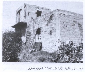
According to the field description recorded by Walid Khalidi, the surviving features of Dayr Sunayd included a railway bridge, unused portions of the railway track, and three buildings belonging to the former train station.
The stone railway bridge crosses a wadi on four broad arches, while the station buildings were described as abandoned and deteriorating. Cactuses, eucalyptus trees, buckthorn, and other thorny vegetation grew on the site, while the surrounding lands were cultivated.
This description is based on fieldwork conducted for Walid Khalidi's study and should not necessarily be treated as a field survey updated to the present day.
Sources
- PalQuestPalQuest – Interactive Encyclopedia of the Palestine Question: Dayr Sunayd
- PalQuestPalQuest – Interactive Encyclopedia of the Palestine Question: Operation Yoav
- Institute for Palestine StudiesInstitute for Palestine Studies: Walid Khalidi, All That Remains
- Palestine RememberedPalestine Remembered: Dayr Sunayd – Gaza District
- sabil.meVillage Statistics of 1945: Population and Land Ownership in the Gaza Sub-District, based on Government of Palestine statistics
- sabil.meVillage Statistics of 1945: Land Use in the Gaza Sub-District, based on Government of Palestine statistics
- Palestine RememberedGovernment of Palestine: Census of Palestine, 1931
Photo gallery


Photos from the village's people
Photos sent in by visitors and published after review.
Add a photo of this village
Log in to add photos of this village.
Other villages from Gaza
More from the archive


 Download Our Palestine App
The whole archive in the palm of your hand: depopulated villages, the Nakba, the massacres and Al-Aqsa — free, with no ads to erase the story.
Download Our Palestine App
The whole archive in the palm of your hand: depopulated villages, the Nakba, the massacres and Al-Aqsa — free, with no ads to erase the story.



Comments
No comments yet — be the first to write one.
Add your comment
Name and email are optional. Comments appear after review.