
The depopulated village of Al-Masmiyya al-Kabira / District of Gaza

Al-Masmiyya al-Kabira
About the depopulated village of Al-Masmiyya al-Kabira
- District
- Gaza
- Date Al-Masmiyya al-Kabira was occupied
- 08 July 1948
- Population in 1948
- 2,923
- Military operation
- Operation An-Far
- Brigade that carried it out
- Givati Brigade
- Distance from the governorate centre
- 41 km northeast of Gaza
- Elevation above sea level
- 75 m
- Cause of displacement
- Expulsion by Israeli occupation forces: the inhabitants of the al-Masmiyya al-Kabira area were driven over Israeli-held territory in the direction of Gaza, in an operation whose orders called for the expulsion of civilians
- Extent of destruction
- The village has been mostly destroyed with the exception of its two schools and several houses remain standing.
- Ethnic cleansing
- al-Masmiyya al-Kabira inhabitants were completely ethnically cleansed.
- Settlements built on the built-up area of Al-Masmiyya al-Kabira after 1948
- Bene Re'em (originally Kerem Re'em) and Chatzav (1949), Yinnon (1952) and Achawa (1976); and two state-sponsored farms built in the 1950s, Mashmi'at Shalom and Chawwat Berurim
Hover a dot to read the village name, or click to open its card.
Borders of the depopulated village of Al-Masmiyya al-Kabira
al-Masmiyya al-Kabira: A Depopulated Palestinian Village in the Gaza District
Al-Masmiyya al-Kabira was a depopulated Palestinian village in the Gaza District, situated on the southern coastal plain approximately 41 kilometers northeast of Gaza at an average elevation of about 75 meters above sea level.
- Subdistrict
- Gaza
- Distance from district center
- 41 km northeast of Gaza
- Average Elevation
- 75 m above sea level
- Population in 1931
- 1,756
- Number of Houses in 1931
- 354
- Population in 1944/1945
- 2,520
- Estimated Population in 1948
- About 2,923 – a later demographic estimate, not an official census
- Total Land Area in 1945
- 20,687 dunams
- Attack and Depopulation
- The village fell at the start of Operation An-Far, launched by the Giv'ati Brigade's First Battalion, and had been occupied by 11 July 1948 according to the New York Times; the History of the War of Independence, as cited by Khalidi, states that it was captured in one of the 'clearing operations' in the brigade's rear-guard. The inhabitants of its area were driven over a strip of Israeli-held territory in the direction of Gaza, according to PalQuest.
- Final Israeli Control
- Between 8 and 11 July 1948: it fell at the start of Operation An-Far (which began on 8 July) and had been occupied by 11 July according to the New York Times as cited by Khalidi; the available sources do not give the exact day
- Military Operation
- Operation An-Far
- Military Unit
- The Giv'ati Brigade – captured in one of the 'clearing operations' in the brigade's rear-guard according to the History of the War of Independence as cited by Khalidi; the brigade's First Battalion carried out Operation An-Far according to PalQuest
- Cause of Depopulation
- Expulsion by Israeli occupation forces: the inhabitants of the al-Masmiyya al-Kabira area were driven over Israeli-held territory in the direction of Gaza, in an operation whose orders called for the expulsion of civilians
- Settlements Documented on Village Lands
- Bene Re'em (originally Kerem Re'em) and Chatzav (1949), Yinnon (1952) and Achawa (1976); and two state-sponsored farms built in the 1950s, Mashmi'at Shalom and Chawwat Berurim
The village occupied an important road junction linking it with al-Majdal to the southwest, Ramla to the northeast, and the Jerusalem–Jaffa highway. The Government of Palestine's 1944/1945 statistics recorded 2,520 inhabitants and a total land area of 20,687 dunums. During the Nakba and the occupation of Palestine in 1948, al-Masmiyya al-Kabira was captured during the opening days of Operation An-Far in July, and its Palestinian population was displaced.
Location of al-Masmiyya al-Kabira
- The village was approximately 41 kilometers northeast of Gaza.
- Its average elevation was about 75 meters above sea level.
- It stood on the southern coastal plain and was bordered by a wadi to the north.
- It occupied a junction of roads leading southwest to al-Majdal, northeast to Ramla, and toward the Jerusalem–Jaffa highway.
- Its twin village, al-Masmiyya al-Saghira, lay approximately two kilometers to the east.
The Name and History of al-Masmiyya al-Kabira
The village was originally known simply as al-Masmiyya. The adjective al-Kabira, meaning “the larger,” was later added to distinguish it from the neighboring village of al-Masmiyya al-Saghira.
The Syrian Sufi traveler Mustafa al-Bakri al-Siddiqi mentioned al-Masmiyya during his travels through the region in the mid-eighteenth century.
Later in the eighteenth century, the French traveler Volney noted that the village produced substantial quantities of spun cotton, indicating the importance of agriculture and domestic production in its local economy.
The Built Environment of al-Masmiyya al-Kabira
In the late nineteenth century, al-Masmiyya al-Kabira had a roughly trapezoidal layout, with the longer base of the trapezoid facing west.
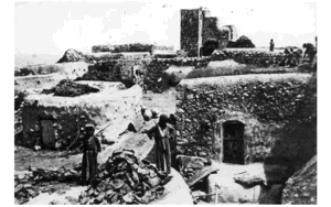
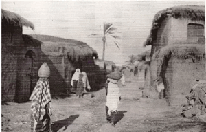
The village was surrounded by gardens, and its houses were built of adobe bricks or concrete. Later construction expanded primarily westward and southwestward.
The built-up area covered approximately 135 dunums according to the 1944/1945 statistics.
Public Facilities and Village Institutions
Al-Masmiyya al-Kabira had a comparatively developed range of local facilities and institutions, including:
- A village council responsible for local public and social affairs.
- Two mosques, locally identified with the Muhanna and Yaghi quarters.
- A boys' school and a girls' school.
- A clinic.
- A petrol station.
- A weekly Thursday market serving residents of neighboring villages.
Education in al-Masmiyya al-Kabira
The boys' school was established in 1922 and developed into a full elementary school.
By the mid-1940s, enrollment reached 307 pupils. Palestinian local documentation states that the pupils were divided among seven grades and taught by eight teachers, with the village contributing toward the salary of one teacher.
The girls' school was established in 1944 and had 39 pupils by the mid-1940s.
Palestinian local documentation also records that approximately 350 men in the village were literate.
Population of al-Masmiyya al-Kabira
The official 1922 Census of Palestine recorded 1,390 inhabitants in al-Masmiyya al-Kabira, all Muslims.
In the 1931 census, the village had 1,756 inhabitants, including 1,752 Muslims and 4 Christians, living in 354 houses.
The Government of Palestine's 1944/1945 statistics recorded a total population of 2,520. Population tables record 2,510 Muslims and 10 Christians.
The figures of 2,923 inhabitants for 1948 and 17,952 refugees for 1998 published by Palestine Remembered are later estimates rather than official censuses.
Population of al-Masmiyya al-Kabira
- 19221,390Official census; all Muslims
- 19311,756Official census: 1,752 Muslims and 4 Christians
- 1944/19452,520Government of Palestine statistics: 2,510 Muslims and 10 Christians
- 19482,923Later estimate published by Palestine Remembered
- 199817,952Later refugee-population estimate published by Palestine Remembered
Number of Houses
The 1931 census recorded 354 houses in al-Masmiyya al-Kabira.
The figure of 589 houses for 1948 published by Palestine Remembered is a later estimate rather than the result of an official census conducted in that year.
Number of Houses in al-Masmiyya al-Kabira
- 1931354Official census
- 1948589Later estimate published by Palestine Remembered
Land Ownership in al-Masmiyya al-Kabira
The total land area recorded for al-Masmiyya al-Kabira in 1944/1945 was 20,687 dunums.
The Arabic Palestine Remembered table uses the categories “Palestinian,” “Transferred to Zionists,” and “Masha'.” These terms are preserved below to reflect that source's terminology. The official Government of Palestine categories were “Arab,” “Jewish,” and “Public.”
Land Ownership in al-Masmiyya al-Kabira, 1944/1945, Using Palestine Remembered Terminology
- Palestinian19,850 dunums96%
- Transferred to Zionists229 dunums1%
- Masha' (source terminology)608 dunums3%
Land Use in al-Masmiyya al-Kabira in 1944/1945
A total of 19,917 dunums was cultivated or classified as cultivable, consisting of 19,684 dunums of Arab land, 229 dunums of Jewish land, and 4 dunums of public land.
Cereals occupied 18,315 dunums. Citrus and bananas covered 1,005 dunums, while plantations and irrigable land occupied another 597 dunums.
Land Use in al-Masmiyya al-Kabira According to the 1944/1945 Statistics
- Arab
- Jewish
- Public
- Citrus and Bananas1,005 dunums
- Plantations and Irrigable Land597 dunums
- Cereals18,315 dunums
- Built-up Area135 dunums
- Non-Cultivable Land635 dunums
Economic Life in al-Masmiyya al-Kabira
Agriculture formed the foundation of the village economy, with cereals and citrus among the principal crops.
Cereal agriculture depended heavily on rainfall, while wells supplied water for citrus groves and fruit orchards. Palestinian sources record some wells as approximately 20 to 50 meters deep.
Villagers also raised livestock and poultry, while some residents worked at a nearby British military camp.
The weekly Thursday market was an important local commercial institution and attracted residents from al-Masmiyya al-Saghira, Yasur, Qastina, Bashshit, Qatra, and other nearby villages.
Operation An-Far
The occupation of al-Masmiyya al-Kabira was associated with Operation An-Far, an offensive launched by the First Battalion of the Giv'ati Brigade on the southern front between 8 and 15 July 1948 during the Ten Days of fighting between the two truces.
The operation sought to expand Giv'ati's area of control southward and eastward and to connect the Israeli-held coast with the Jewish settlements in the Negev.
Egyptian forces partially blocked the southward advance, and the operation failed to achieve a complete link with the Negev. It nevertheless resulted in the capture and depopulation of numerous Palestinian villages south of Ramla near the meeting point of the Gaza, Hebron, and Ramla districts.
The orders issued to Giv'ati's First Battalion included the expulsion of civilians from captured areas, and the operation displaced more than 20,000 Palestinians from the region.
The Occupation of al-Masmiyya al-Kabira in July 1948
Sources differ over the precise day on which al-Masmiyya al-Kabira fell.
Palestine Remembered gives 8 July 1948, the opening date of Operation An-Far, while other Palestinian documentation gives 9 July.
Walid Khalidi and PalQuest, citing The New York Times, state that the village was already under Israeli control by 11 July.
It is therefore most precise to state that al-Masmiyya al-Kabira was captured during the opening days of Operation An-Far, between 8 and 11 July 1948, and was definitely occupied by 11 July.
Its capture was strategically significant because of the village's road-junction location and helped obstruct an Egyptian attempt to advance from the direction of al-Majdal toward al-Latrun.
The Displacement of the Villagers
The displacement of al-Masmiyya al-Kabira formed part of the large-scale depopulation of Palestinian villages south of Ramla during Operation An-Far.
PalQuest records that the orders issued to Giv'ati's First Battalion called for civilians to be expelled from occupied areas, although later Israeli accounts claimed that villagers had left before advancing troops arrived.
For the al-Masmiyya al-Kabira area specifically, PalQuest states that inhabitants were driven across a strip of Israeli-held territory toward Gaza, while other displaced people from the wider operational area moved east toward Hebron.
Occupation and Depopulation Chronology
- 8 July 1948
Beginning of the military operation
The Giv'ati Brigade's First Battalion launched Operation An-Far on the southern front during the 'Ten Days' between the two truces; its aims included expelling civilians from the occupied area, and PalQuest lists al-Masmiyya al-Kabira among the villages affected by it.
- Between 8 and 11 July 1948
Final occupation
The village fell at the start of the operation, at the same time as al-Tina (attacked on 8–9 July), al-Masmiyya al-Saghira and al-Jaladiyya, according to PalQuest, and the New York Times reported that it had been occupied by 11 July, blocking an Egyptian attempt to break through to al-Latrun from the direction of al-Majdal. The History of the War of Independence, as cited by Khalidi, states that it was captured during 'several clearing operations in the brigade's rear-guard, to eliminate the threat and danger posed by the presence of Arab civilian concentrations to the rear of the front'.
- July 1948
Expulsion of the inhabitants
The inhabitants of the al-Masmiyya al-Kabira area were driven over a strip of Israeli-held territory in the direction of Gaza, according to PalQuest; the orders of the Giv'ati Brigade's First Battalion called for the expulsion of civilians, although Giv'ati sources later claimed that the inhabitants fled before the advancing columns reached their villages.
- 1949
Settlement on village lands
The settlements of Bene Re'em (originally Kerem Re'em) and Chatzav were founded on village lands.
- 1952
Settlement on village lands
The settlement of Yinnon was founded on village lands.
- 1950s
State-sponsored farms on village lands
Two state-sponsored farms, Mashmi'at Shalom and Chawwat Berurim, were built on village lands.
- 1976
Settlement on village lands
The settlement of Achawa was founded on village lands.
Settlements Established on the Lands of al-Masmiyya al-Kabira
Walid Khalidi and PalQuest identify four settlements and two state-sponsored farms on the lands of al-Masmiyya al-Kabira:
- Bene Re'em, originally called Kerem Re'em: established in 1949.
- Chatzav: established in 1949.
- Yinnon: established in 1952.
- Achawa: established in 1976.
- Mashmi'at Shalom: a state-sponsored farm established on village land during the 1950s.
- Chawwat Berurim: a state-sponsored farm established on village land during the 1950s.
The Site of al-Masmiyya al-Kabira After the Nakba
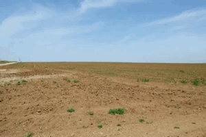
According to Walid Khalidi's field description, the two village schools and several houses remained standing after most of al-Masmiyya al-Kabira had been destroyed.
The girls' school was deserted at the time of the survey, while the boys' school had been converted into an Israeli military installation.
Several surviving concrete houses had flat roofs and rectangular doors and windows. Some remained inhabited, others were used as warehouses, and one had been converted into a juice shop.
Khalidi also recorded a date palm growing in the courtyard of a house that had belonged to the Palestinian Tawfiq al-Rabi.
An Israeli petrol station was established on the site of the former Palestinian station that had belonged to Hasan 'Abd al-'Aziz Muhanna and Nimr Muhanna, while Israeli farmers cultivated the surrounding lands.
This description is based on fieldwork conducted for Walid Khalidi's All That Remains and should not necessarily be treated as an updated field survey of the site today.
Sources
- PalQuest – Interactive Encyclopedia of the Palestine Question: al-Masmiyya al-Kabira.
- PalQuest – Interactive Encyclopedia of the Palestine Question: Operation An-Far.
- Walid Khalidi, All That Remains.
- Government of Palestine, Census of Palestine, 1922.
- E. Mills, Census of Palestine, 1931.
- Government of Palestine, Village Statistics, April 1945.
- Palestine Remembered: al-Masmiyya al-Kabira – Gaza District.
- Palestinian Villages Encyclopedia: al-Masmiyya al-Kabira.
- Palestinian Encyclopedia: al-Masmiyya al-Kabira.
Photo gallery


Photos from the village's people
Photos sent in by visitors and published after review.
Add a photo of this village
Log in to add photos of this village.
More from the archive


 Download Our Palestine App
The whole archive in the palm of your hand: depopulated villages, the Nakba, the massacres and Al-Aqsa — free, with no ads to erase the story.
Download Our Palestine App
The whole archive in the palm of your hand: depopulated villages, the Nakba, the massacres and Al-Aqsa — free, with no ads to erase the story.



Comments
No comments yet — be the first to write one.
Add your comment
Name and email are optional. Comments appear after review.