
The depopulated village of Bayt Tima / District of Gaza

Bayt Tima
About the depopulated village of Bayt Tima
- District
- Gaza
- Date Bayt Tima was occupied
- 18 October 1948
- Population in 1948
- 1,230
- Military operation
- Operation Yoav
- Brigade that carried it out
- Givati Brigade
- Who defended the village
- Egyptian Army
- Distance from the governorate centre
- 21 (km) North East of Gaza
- Elevation above sea level
- 75 m
- Cause of displacement
- Military assault by Zionist troops
- Extent of destruction
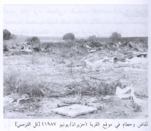
- The village has been completely destroyed, and only house rubble left behind.
- Ethnic cleansing
- Bayt Tima inhabitants were completely ethnically cleansed.
Hover a dot to read the village name, or click to open its card.
Borders of the depopulated village of Bayt Tima
Bayt Tima: A Depopulated Palestinian Village in the Gaza District
Bayt Tima was a Palestinian village in the Gaza District, located approximately 21 km northeast of Gaza city on flat terrain in the southern coastal plain, at an average elevation of about 75 metres above sea level. Its inhabitants were displaced during the Nakba and the occupation of Palestine in 1948. The village was most probably occupied by Israeli occupation forces on 18–19 October 1948 during the early stages of Operation Yoav.
Location of Bayt Tima
Bayt Tima stood on flat terrain in the southern coastal plain in an area rich in archaeological remains.
A secondary road connected the village with the main coastal highway a short distance to the west, providing access to Gaza and the town of al-Majdal. Local roads also connected Bayt Tima with neighbouring villages, including Kawkaba, Hulayqat, and al-Jiyya.
The village was approximately 21 km northeast of Gaza city and stood at an average elevation of about 75 metres above sea level.
Bayt Tima during the Ottoman Period
In 1596, Bayt Tima was a village in the nahiya of Gaza within the liwa of Gaza, with an estimated population of approximately 693.
The inhabitants paid taxes on crops and products including wheat, barley, fruit, almonds, sesame, goats, and beehives.
Architecture and Services in Bayt Tima
In the late nineteenth century, Bayt Tima was described as a moderately sized village containing two pools, several shrines, and two adjoining patches of gardens.
During the British Mandate period, the village had its own shops and mosque. Most houses were constructed of mud and adobe and were grouped into compact blocks separated by streets and open spaces. The largest cluster of houses occupied the centre of the village.
Most of Bayt Tima's inhabitants were Muslim.
Education in Bayt Tima
Bayt Tima shared an elementary school with the neighbouring villages of Kawkaba and Hulayqat. The school was built in 1946.
Palestine Remembered states that the school was for boys and enrolled 136 pupils in 1946, taught by three teachers. Khalidi's PalQuest entry confirms the establishment of the shared school but does not provide those detailed enrolment and staffing figures.
Economic Life in Bayt Tima
The inhabitants relied primarily on rainfed agriculture. They cultivated cereals, vegetables, and fruit, particularly figs, apricots, and almonds.
According to the 1944/45 statistics, 10,444 dunums were devoted to cereals, while 197 dunums were irrigated or used for plantations.
Land Ownership in Bayt Tima
The total land area of Bayt Tima was 11,032 dunums according to the 1944/45 statistics.
Land ownership in Bayt Tima, 1944/45
- Arab10,753 dunums97%
- Jewish0 dunums0%
- Public279 dunums3%
Palestine Remembered presents the corresponding Arabic categories as 10,753 Palestinian dunums, zero dunums “transferred to Zionists,” and 279 dunums of communal land.
Land Use in Bayt Tima, 1944/45
Land use in Bayt Tima
- Arab
- Public
- Cereals10,444 dunums
- Plantations and irrigable land197 dunums
- Built-up area60 dunums
- Non-cultivable land331 dunums
A total of 10,641 dunums was cultivated or cultivable, representing approximately 96 percent of the village lands. Built-up and non-cultivable areas together amounted to 391 dunums.
Population of Bayt Tima
Population of Bayt Tima in selected years
- 1596693Estimate derived from Ottoman tax records
- 1922606Official British Mandate census
- 1931762Official British Mandate census
- 1944/451,060Official statistics
- 19481,230Later estimate published by Palestine Remembered
- Estimated refugees in 19987,551Later estimate published by Palestine Remembered
Number of Houses in Bayt Tima
Number of houses in Bayt Tima
- 1931157Official census figure
- 1948253Later estimate published by Palestine Remembered
Archaeological Remains in Bayt Tima
Bayt Tima stood in an area rich in archaeological remains. In the cemetery south of the village, a badly worn mosaic pavement was discovered, suggesting a Roman or Byzantine presence at the site.
Architectural elements from earlier periods had also been reused in the construction of the village mosque, indicating a long history of settlement and building in the area.
Attacks on Bayt Tima before its Final Occupation
Bayt Tima was subjected to several attacks and incursions before its final occupation. On 9 February 1948, the Palestinian newspaper Filastin reported a Zionist attempt to infiltrate the village. The defenders repelled the attempt during an exchange of fire lasting approximately thirty minutes.
Walid Khalidi and PalQuest also reproduce an account, attributed to Israeli sources through the Associated Press, claiming that Israeli occupation forces entered Bayt Tima on 1 June 1948. If such an occupation occurred, it was brief and did not constitute the village's final capture.
An account by Egyptian writer Muhammad Abd al-Mun'im states that by the end of the first truce, in early July 1948, Bayt Tima remained in the hands of Palestinian fighters. When Israeli occupation forces moved toward the village and occupied overlooking hills, its defenders were reinforced by a Saudi company serving on the southern front.
The village remained in Arab hands throughout the second truce, confirming that the earlier incursions did not result in permanent occupation.
Occupation and Depopulation of Bayt Tima during the Nakba
In mid-October 1948, Bayt Tima and the surrounding area were subjected to aerial and artillery bombardment during the opening stages of Operation Yoav. The attacks caused large numbers of residents and refugees in the area to flee.
Walid Khalidi and PalQuest place the final occupation of the village on 18–19 October 1948, during the early stages of Operation Yoav. The New York Times later cited an Israeli military communiqué issued on 20 October announcing that Bayt Tima had fallen together with Kawkaba and Hulayqat.
Khalidi's village entry considers it likely that the Giv'ati Brigade captured Bayt Tima. Palestine Remembered gives 18 October 1948 as the specific occupation date and identifies the Giv'ati Brigade as the attacking unit and the Egyptian Army as the defending force.
Bayt Tima was among the villages affected by Operation Yoav, which lasted from 15 October to 4 November 1948. The operation involved the Giv'ati, Yiftach, Negev, and Har'el brigades against Egyptian forces on the southern front.
- Most probable date of final occupation: 18–19 October 1948.
- Palestine Remembered date: 18 October 1948.
- Military operation: Operation Yoav.
- Probable attacking unit: Giv'ati Brigade.
- Defending force: Palestine Remembered identifies the Egyptian Army, while Palestinian fighters and a Saudi company are documented as defending the area during an earlier phase.
- Fate of the inhabitants: bombardment, military assault, and occupation resulted in the displacement of the village's population during the Nakba.
- Fate of the village: the village was subsequently destroyed, leaving rubble at the site.
Palestine Remembered states in its summary data that a massacre occurred at Bayt Tima. Khalidi's dedicated PalQuest entry, however, does not provide independently documented details of a specific massacre or a verified casualty figure. This article therefore does not present a massacre or casualty number as an established fact.
Settlements Established on the Lands of Bayt Tima
According to Walid Khalidi and PalQuest, no Israeli settlements were established on the lands of Bayt Tima itself.
Bayt Tima Today
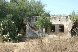
According to the field description published by Walid Khalidi in All That Remains, sycamore and carob trees grew around the rubble of the former village, while the surrounding land was being used for agriculture.
This description derives from field research published in Khalidi's book in 1992. Palestine Remembered also contains later photographs of the village site, including material added in 2015, but these contributions do not constitute a comprehensive independent field survey.
The approved sources used here therefore do not provide a sufficiently comprehensive and independent contemporary field verification of the condition of every part of the Bayt Tima site in 2026.
Sources
Photo gallery


Photos from the village's people
Photos sent in by visitors and published after review.
Add a photo of this village
Log in to add photos of this village.
Other villages from Gaza
More from the archive


 Download Our Palestine App
The whole archive in the palm of your hand: depopulated villages, the Nakba, the massacres and Al-Aqsa — free, with no ads to erase the story.
Download Our Palestine App
The whole archive in the palm of your hand: depopulated villages, the Nakba, the massacres and Al-Aqsa — free, with no ads to erase the story.



Comments
No comments yet — be the first to write one.
Add your comment
Name and email are optional. Comments appear after review.