
The depopulated village of Hiribya / District of Gaza
Hiribya
About the depopulated village of Hiribya
- District
- Gaza
- Date Hiribya was occupied
- 01 November 1948
- Population in 1948
- 2,598
- Military operation
- Operation Yoav
- Who defended the village
- Egyptian Army
- Distance from the governorate centre
- 14 km northeast of Gaza
- Elevation above sea level
- 25 m
- Cause of displacement
- The military operations of Israeli occupation forces in Operation Yoav, beginning with the aerial bombardment of the village and followed by its fall
- Extent of destruction
- The village was mostly destroyed with the exception of the village mosque.
- Ethnic cleansing
- Hiribya inhabitants were completely ethnically cleansed.
- Settlements built on the land of Hiribya before 1948
- Yad Mordekhay, founded in 1943, has expanded onto village lands
- Settlements built on the built-up area of Hiribya after 1948
- Ziqim (1949) and Karmiyya (1950) on village lands
Hover a dot to read the village name, or click to open its card.
Borders of the depopulated village of Hiribya
Hiribya: A Depopulated Palestinian Village in the Gaza District
Hiribya was a Palestinian village in the Gaza District, situated on the southern coastal plain approximately 14 kilometres northeast of the city of Gaza, at an average elevation of about 25 metres above sea level. The village was subjected to aerial bombardment during Operation Yoav on 15–16 October 1948 and was probably occupied by Israeli forces in early November, after the fall of al-Majdal and near the end of the operation. Its Palestinian inhabitants were displaced and most of the village was subsequently destroyed.
- Subdistrict
- Gaza
- Distance from district center
- 14 km northeast of Gaza
- Average Elevation
- 25 m above sea level
- Population in 1931
- 1,520 – includes Ashraf
- Number of Houses in 1931
- 234 – includes Ashraf
- Population in 1944/1945
- 2,240 – Arab population; the same statistical unit also recorded 60 Jews (total 2,300)
- Estimated Population in 1948
- About 2,598 – a later demographic estimate, not an official census
- Total Land Area in 1945
- 22,312 dunams
- Attack and Depopulation
- The village was bombed from the air on 15–16 October 1948 at the start of Operation Yoav; a later attack on it was planned but postponed or called off when a large Egyptian force was reported quartered there. Khalidi considers that it probably fell to Israeli forces in early November 1948.
- Final Israeli Control
- Probably early November 1948, shortly after the occupation of al-Majdal at the end of Operation Yoav, according to Khalidi, who notes that it is difficult to determine precisely when the village was occupied; the available sources give no exact day.
- Military Operation
- Operation Yoav
- Cause of Depopulation
- The military operations of Israeli occupation forces in Operation Yoav, beginning with the aerial bombardment of the village and followed by its fall
- Settlements Documented on Village Lands
- Ziqim (1949) and Karmiyya (1950) on village lands; the settlement of Yad Mordekhay, founded in 1943, has expanded onto village lands
Location
Hiribya stood on the southern coastal plain in a flat area surrounded by sand dunes, approximately 14 kilometres northeast of Gaza.
The village had an average elevation of about 25 metres above sea level.
A secondary road connected Hiribya with the coastal highway, which passed approximately 2 kilometres to the east and provided access to Gaza to the south and al-Majdal to the north.
The lands of Hiribya bordered a number of Palestinian villages, including al-Khisas, Barbara, Bayt Jirja, Dayr Sunayd, and Bayt Lahiya.
Hiribya Through History
Archaeological remains at Hiribya indicate that the area had been inhabited since antiquity, and some studies associate the site with the Canaanite period.
The Crusaders knew the village as “Forbie,” while the Arab geographer Yaqut al-Hamawi referred to it in the thirteenth century as “Firbiya” and placed it within the administrative jurisdiction of Ascalon.
The Battle of Hiribya, 1244
In 1244, the area of Hiribya was the scene of a major battle between Muslim forces and a combined Crusader force and its allies. Known in historical literature as the Battle of Hiribya or La Forbie, it is regarded as one of the major military confrontations of the Crusader period in Palestine after the Battle of Hittin.
In 1596, Hiribya was a village in the nahiya of Gaza in the Gaza district, with an estimated population of approximately 963.
Its inhabitants paid taxes on wheat, barley, grapes, fruit, cotton, and other agricultural products.
Architecture
In the late nineteenth century, Hiribya had an approximately rectangular layout, although some adobe houses were scattered among the surrounding orchards.
A pond, a well, and several gardens were located around the village.
Remains of a Crusader fortress stood to the south.
Village construction later expanded along the roads leading toward the coastal highway.
According to the 1944/1945 statistics, 42 dunams of built-up land were Arab-owned, while another 50 dunams of built-up land were Jewish-owned within the statistical unit, producing a total built-up area of 92 dunams.
Population
Palestine Remembered gives a population of 1,037 for Hiribya in the 1922 census.
In 1931, the recorded population reached 1,520 living in 234 houses. PalQuest notes that the census unit included Ashraf.
According to the 1944/1945 statistics, the statistical unit had a total population of 2,300, including 2,240 Arabs and 60 Jews.
The estimate of approximately 2,598 inhabitants for 1948 and 15,957 refugees and descendants in 1998 published by Palestine Remembered are later estimates rather than official British Mandate censuses.
Population Figures Associated with Hiribya
- 1596About 963Historical estimate based on Ottoman records
- 19221,037Official census as reproduced by Palestine Remembered
- 19311,520Official census; the statistical unit included Ashraf
- 1944/19452,3002,240 Arabs and 60 Jews in the statistical unit
- 1948About 2,598Later estimate
- 199815,957Estimate of refugees and their descendants
Number of Houses
The 1931 census recorded 234 houses in the population unit that included Hiribya and Ashraf.
The figure of approximately 399 houses for 1948 is a later estimate rather than an official census figure.
Education and Religious Life
A mosque and an elementary school stood in the centre of Hiribya.
The school opened in 1922 and had approximately 124 pupils by the mid-1940s.
The Palestinian inhabitants of the village were Muslims.
Land of Hiribya
According to the 1944/1945 statistics, the lands of Hiribya covered a total of 22,312 dunams.
Arab ownership amounted to 12,987 dunams, Jewish ownership to 1,226 dunams, while 8,099 dunams were classified as public land.
Land Ownership in Hiribya in 1944/1945
- Arab ownership12,987 dunums58%
- Jewish ownership1,226 dunums5%
- Public land8,099 dunums36%
Agriculture and Economic Life
The inhabitants of Hiribya depended primarily on agriculture. Adequate rainfall and groundwater close to the surface contributed to intensive cultivation, and the village was described as resembling an oasis amid the surrounding sand dunes.
Hiribya was particularly known for citrus cultivation, alongside grapes, bananas, sugar cane, cereals, and other crops.
According to the 1944/1945 statistics, 2,765 dunams were devoted to citrus and bananas, all Arab-owned.
Irrigated and plantation land covered 6,106 dunams, including 5,706 Arab-owned dunams and 400 Jewish-owned dunams.
Cereal cultivation covered a total of 7,179 dunams: 4,366 Arab-owned dunams, 776 Jewish-owned dunams, and 2,037 dunams of public land.
Land Use in Hiribya in 1944/1945, in Dunams
- Arab
- Jewish
- Public
- Citrus and bananas2,765 dunums
- Irrigated and plantation land6,106 dunums
- Cereals7,179 dunums
- Built-up area92 dunums
- Uncultivable land6,170 dunums
Archaeology
Hiribya contained archaeological remains indicating ancient settlement, including the remains of a tower, architectural fragments, and water reservoirs southwest of the village.
Khirbat al-Sharf was identified by some researchers with the Roman town of Diocletianopolis, also known as Sarafia.
Farther east stood Khirbat al-Yasmina, which contained remains dating to the Byzantine period.
The Nakba and Operation Yoav
Operation Yoav
Operation Yoav began on 15 October 1948 and continued until 4 November. It was directed against Egyptian forces and Palestinian areas on the southern front.
Forces from the Givati, Yiftach, Negev, and Harel brigades participated in the operation.
The offensive resulted in the occupation of numerous Palestinian towns and villages in and around the Gaza District and contributed to the collapse of much of the Egyptian defensive line in the area.
The Bombardment and Occupation of Hiribya
The precise date of Hiribya's occupation is difficult to establish.
The village came under aerial bombardment on the night of 15–16 October 1948 at the beginning of Operation Yoav, together with several other Palestinian towns and villages in the area.
Later in the operation, an assault on Hiribya was planned. Walid Khalidi and PalQuest, transmitting an Israeli military account, state that the assault was cancelled or postponed after reports arrived that a large Egyptian force was stationed in the village.
Khalidi considers it probable that Hiribya fell to Israeli forces in early November 1948, shortly after the occupation of al-Majdal to the north and at or immediately after the end of Operation Yoav.
Palestine Remembered gives 1 November 1948 as a summary occupation date and tentatively attributes the attack to the Givati Brigade. The more detailed account, however, does not conclusively identify either the precise day or the unit that finally occupied the village. This article therefore uses “early November 1948” without assigning the final capture to a specific brigade.
The Israeli military account is cited here only as transmitted through Walid Khalidi and PalQuest and not through direct reliance on the original Israeli source.
Occupation and Depopulation Chronology
- 15 October 1948
Beginning of the military operation
Israeli occupation forces launched Operation Yoav against Egyptian forces on the southern front as soon as the second truce ended, with the Giv'ati, Yiftach, Negev and Har'el brigades. Hiribya was among the villages targeted for attack during this operation.
- 15–16 October 1948
Shelling of the village
The village was bombed from the air along with other towns and villages in the area.
- Early November 1948 (probably)
Final occupation
Later in the operation an attack on the village was planned, but it was postponed or called off when a large Egyptian force was reported quartered there, according to the Israeli History of the War of Independence as cited by Khalidi. Khalidi considers that the village probably fell to Israeli forces shortly after the occupation of al-Majdal at the end of Operation Yoav; the sources give no exact day.
- 1949–1950
Settlement on village lands
The settlements of Ziqim (1949) and Karmiyya (1950) were established on village lands, and the settlement of Yad Mordekhay, founded in 1943, expanded onto village lands.
Displacement and Fate of the Village
The fall of Hiribya resulted in the displacement of its Palestinian population and the end of the village community at its original site.
Most of the village's built environment was subsequently destroyed, and its inhabitants were not permitted to re-establish their community there.
Israeli Settlements on the Lands of Hiribya
Yad Mordekhay
Yad Mordekhay was established in 1943 before the Nakba and later expanded onto parts of Hiribya's lands.
Ziqim
Ziqim was established in 1949 on Hiribya's lands.
Karmiyya
Karmiyya was established in 1950 on the lands of the village.
- 1943Yad Mordekhay
Established before the Nakba and later expanded onto Hiribya's lands
- 1949Ziqim
Established on Hiribya's lands
- 1950Karmiyya
Established on Hiribya's lands
The Site of Hiribya After the Nakba
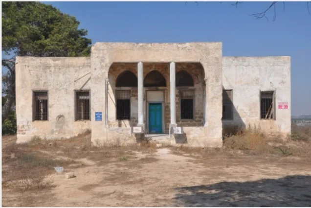
According to the field documentation relied upon by Walid Khalidi, the mosque and the house of Muhammad Atiyya were among the few buildings that survived at the village site.
The mosque had been converted into a warehouse at the time of documentation.
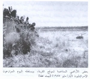
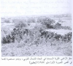
Cactuses, camomile, shrubs, and sycamore trees covered parts of the site.
The surrounding lands were cultivated with wheat, avocados, and other crops.
This description reflects the condition of the site during the period of field documentation relied upon by Walid Khalidi and should not necessarily be interpreted as a comprehensive survey updated to 2026.
Sources
- PalQuest – Interactive Encyclopedia of the Palestine Question: Hiribya.
- PalQuest: Hiribya.
- PalQuest: Operation Yoav.
- Palestine Remembered: Hiribya, Gaza District.
- Palestine Remembered: Hiribya.
- Walid Khalidi, All That Remains, entry on Hiribya.
- Arif al-Arif, works on the history of Gaza.
- Government of Palestine, censuses of 1922 and 1931.
- Government of Palestine, Department of Statistics, Village Statistics, 1945.
Photo gallery


Photos from the village's people
Photos sent in by visitors and published after review.
Add a photo of this village
Log in to add photos of this village.
Other villages from Gaza
More from the archive


 Download Our Palestine App
The whole archive in the palm of your hand: depopulated villages, the Nakba, the massacres and Al-Aqsa — free, with no ads to erase the story.
Download Our Palestine App
The whole archive in the palm of your hand: depopulated villages, the Nakba, the massacres and Al-Aqsa — free, with no ads to erase the story.



Comments
No comments yet — be the first to write one.
Add your comment
Name and email are optional. Comments appear after review.