
The depopulated village of Al-Jaladiyya / District of Gaza

Al-Jaladiyya
About the depopulated village of Al-Jaladiyya
- District
- Gaza
- Date Al-Jaladiyya was occupied
- 09 July 1948
- Population in 1948
- 418
- Military operation
- Operation An-Far
- Brigade that carried it out
- Probably units of the Giv'ati Brigade, according to Khalidi; the available sources do not identify the battalion
- Distance from the governorate centre
- 34 km northeast of Gaza
- Elevation above sea level
- 75 m
- Cause of displacement
- Direct military assault by Israeli occupation forces in an operation whose orders called for the expulsion of civilians; the inhabitants fled eastwards towards Hebron or southwards to the Gaza Strip
- Extent of destruction
- The village was completely defaced.
- Ethnic cleansing
- al-Jaladiyya inhabitants were completely ethnically cleansed.
- Settlements built on the built-up area of Al-Jaladiyya after 1948
- No Israeli settlements on village lands, according to Khalidi; Shafir (1949) and Zerachya (1950), near the village site, are on the lands of al-Sawafir al-Sharqiyya
Hover a dot to read the village name, or click to open its card.
Borders of the depopulated village of Al-Jaladiyya
al-Jaladiyya: A Depopulated Palestinian Village in the Gaza District
al-Jaladiyya was a Palestinian village in the Gaza District, situated on slightly elevated ground on the southern coastal plain approximately 34 kilometres northeast of Gaza, at an average elevation of about 75 metres above sea level. Its population reached 360 in the 1944/1945 statistics, all Muslims. The village was occupied on approximately 8–10 July 1948 by units of the Giv'ati Brigade during the opening stage of the offensive associated with Operation An-Far, and its inhabitants were displaced during the Nakba and the occupation of Palestine in 1948.
- Subdistrict
- Gaza
- Distance from district center
- 34 km northeast of Gaza
- Average Elevation
- 75 m above sea level
- Population in 1931
- 228
- Number of Houses in 1931
- 50
- Population in 1944/1945
- 360
- Estimated Population in 1948
- About 418 – a later demographic estimate, not an official census
- Total Land Area in 1945
- 4,329 dunams – of which 4,328 dunams public land and 1 dunam Arab-owned
- Attack and Depopulation
- Units of the Giv'ati Brigade probably occupied the village on 9–10 July 1948, in the first stage of the 'Ten Days' offensive on the southern front between the two truces, and its inhabitants fled eastwards towards Hebron or southwards to the Gaza Strip. Although Giv'ati sources later recalled that the people fled before the units entered, the Brigade's operational orders had demanded that civilians be expelled.
- Final Israeli Control
- Probably 9–10 July 1948, in the first stage of the operation, according to Khalidi; the available sources do not establish the day of occupation with certainty
- Military Operation
- Operation An-Far – PalQuest's al-Jaladiyya entry does not name the operation and the village is not in the operation's list of affected villages, but PalQuest's entry on al-Tina states that al-Jaladiyya was seized at the same time, at the start of the operation
- Military Unit
- Probably units of the Giv'ati Brigade, according to Khalidi; the available sources do not identify the battalion
- Cause of Depopulation
- Direct military assault by Israeli occupation forces in an operation whose orders called for the expulsion of civilians; the inhabitants fled eastwards towards Hebron or southwards to the Gaza Strip
- Settlements Documented on Village Lands
- No Israeli settlements on village lands, according to Khalidi; Shafir (1949) and Zerachya (1950), near the village site, are on the lands of al-Sawafir al-Sharqiyya
Location
al-Jaladiyya stood on slightly elevated ground on the southern coastal plain, approximately 34 kilometres northeast of Gaza.
Its average elevation was about 75 metres above sea level, and Wadi Suqrir bordered the village on the southeast.
Secondary roads linked al-Jaladiyya with al-Faluja to the south, with the highway leading toward al-Majdal to the southwest, and with a number of neighbouring Palestinian villages.
The village lands bordered or lay near those of al-Sawafir al-Sharqiyya, Tall al-Turmus, Jusayr, Summil, and other communities in the area.
al-Jaladiyya Through History
Modern al-Jaladiyya may have stood near a site associated with the Crusader castle known as Geladia.
Researchers involved in the late nineteenth-century Survey of Western Palestine, as well as later specialists in Crusader history, considered Khirbat Jaladiyya the more likely location of the castle, pointing to architectural remains including part of a tower.
In 1596, al-Jaladiyya was a village in the nahiya of Gaza in the Gaza district, with an estimated population of approximately 88.
The inhabitants paid taxes on wheat, barley, sesame, vineyards, goats, beehives, and other forms of production.
The site appears to have been abandoned sometime during the seventeenth century and was not permanently resettled until the 1870s.
Architecture and Public Facilities
The inhabitants of al-Jaladiyya were Muslims, and most village houses were built of adobe.
The mosque was the principal public building and was constructed in 1890 by order of Ottoman Sultan Abd al-Hamid II.
It consisted of two sections, one used for prayer and the other for education.
The built-up area covered approximately 63 dunams in the 1944/1945 statistics.
Education
Education in al-Jaladiyya was closely connected with the mosque, one section of which was used as a school.
By the mid-1940s, 43 pupils were enrolled in the mosque school.
Palestine Remembered also classifies this institution as a boys' school established in 1945. The more cautious formulation is therefore that a boys' school operated in the educational section of the village mosque by the mid-1940s.
Population
The 1922 census recorded 232 inhabitants in al-Jaladiyya.
By the 1931 census, the population stood at 228 people living in 50 houses.
According to the 1944/1945 statistics, the village population reached 360, all Arab Muslims.
The estimate of approximately 418 inhabitants in 1948 is a later demographic estimate rather than an official British Mandate census figure.
Palestine Remembered estimates the number of refugees and their descendants at 2,565 in 1998.
Population of al-Jaladiyya
- 1596About 88Historical estimate based on Ottoman records
- 1922232Official census
- 1931228Official census
- 1944/1945360Government of Palestine statistics; all Muslims
- 1948About 418Later estimate
- 19982,565Estimate of refugees and their descendants
Number of Houses
The 1931 census recorded 50 houses in al-Jaladiyya.
The figure of approximately 91 houses in 1948 is a later estimate rather than an official census count.
Land Ownership
According to the 1944/1945 statistics, al-Jaladiyya had a total land area of 4,329 dunams.
The village had an unusual statistical land classification: only 1 dunam was recorded as privately Arab-owned, while 4,328 dunams were classified as public land. No Jewish-owned land was recorded.
The public-land category should not therefore be represented as privately owned Arab land, even though the villagers cultivated most of this area.
Land Ownership in al-Jaladiyya in 1944/1945
- Private Arab ownership1 dunums<1%
- Jewish ownership0 dunums0%
- Public land4,328 dunums100%
Agriculture and Economic Life
Rain-fed agriculture formed the basis of al-Jaladiyya's economy.
Cereals were the principal crop.
According to the 1944/1945 statistics, 4,185 dunams were devoted to cereal cultivation, all statistically classified as public land.
The built-up area covered 63 dunams, also classified as public land.
Uncultivable land covered 81 dunams: 1 privately Arab-owned dunam and 80 dunams of public land.
Land Use in al-Jaladiyya in 1944/1945, in Dunams
- Arab
- Public
- Cereals4,185 dunums
- Built-up area63 dunums
- Uncultivable land81 dunums
Khirbat Jaladiyya and Archaeological Remains
Khirbat Jaladiyya is associated with the Crusader castle known as Geladia.
Archaeological surveys recorded architectural remains at the khirba, including part of what was identified as a tower, leading researchers to regard it as the likely site of the Crusader fortification.
The principal sources reviewed do not provide enough information to date all archaeological remains at the site precisely.
Operation An-Far
Operation An-Far began on 8 July 1948 and continued until 15 July during the Ten Days between the two truces.
The operation was carried out by the Giv'ati Brigade, with its First Battalion leading the main offensive.
Its objectives included expanding Giv'ati's area of control southward and eastward and attempting to link the Israeli-held coastal area with Jewish settlements in the Negev.
The operational orders also called for civilians to be expelled from occupied areas.
Egyptian forces partially blocked the southward advance, preventing the operation from fully achieving its territorial objective, but approximately sixteen Palestinian villages were occupied and more than 20,000 inhabitants were displaced from the area south of Ramla between the coast and the Hebron foothills.
The Occupation and Depopulation of al-Jaladiyya
al-Jaladiyya lay within the area attacked by the Giv'ati Brigade during the Ten Days between the two truces.
The sources differ slightly over the precise occupation date. Palestine Remembered's summary gives 8 July 1948, while the detailed Walid Khalidi and PalQuest account considers it more likely that the village was occupied during the first stage of the offensive on 9–10 July.
This article therefore uses the range 8–10 July 1948.
The detailed village account attributes the capture to units of the Giv'ati Brigade.
Although the wider Operation An-Far offensive was led by Giv'ati's First Battalion, the al-Jaladiyya entry does not identify the specific battalion that directly entered the village. This article therefore does not assign the capture to a particular battalion.
There is also a limited documentary inconsistency: PalQuest's short list of villages affected by Operation An-Far does not include al-Jaladiyya, while the village-specific narrative places its capture in the opening stage of the same offensive. The detailed al-Tina entry also states that al-Jaladiyya was among the villages seized at the beginning of Operation An-Far.
The strongest reading of the detailed evidence is therefore that al-Jaladiyya was occupied in the context of Operation An-Far, while acknowledging the omission from the operation's short affected-villages list.
Some villagers moved east toward the Hebron area after their displacement, while others went south toward the Gaza Strip.
Operational orders of the Giv'ati Brigade, as transmitted by Walid Khalidi and PalQuest from Israeli records, called for the expulsion of civilians from the occupied area, although later Giv'ati accounts claimed that residents had left before the advancing units reached the villages.
Such Israeli-source material is cited here only as transmitted through Walid Khalidi and PalQuest, not through direct reliance on the original Israeli sources.
Occupation and Depopulation Chronology
- 8 July 1948
Beginning of the military operation
In the period between the two truces of the war (the 'Ten Days', 8–18 July 1948), the Giv'ati Brigade's First Battalion launched Operation An-Far on the southern front to extend the area of control southwards towards the Negev; over sixteen villages between the coast and the Hebron foothills were occupied and at least 20,000 people were driven from their homes, according to figures cited by Benny Morris as quoted by Khalidi.
- Probably 9–10 July 1948
Final occupation
Al-Jaladiyya was probably occupied in the first stage of the operation by units of the Giv'ati Brigade, according to Khalidi, and PalQuest's al-Tina entry states that it was seized at the same time as al-Tina, al-Masmiyya al-Kabira and al-Masmiyya al-Saghira. A New York Times correspondent wrote that one effect of the capture of these villages was to block the possibility of an Egyptian breakthrough to al-Latrun.
- July 1948
Depopulation of the village
The inhabitants fled either eastwards towards Hebron, like most of the refugees from the area seized during the operation, or southwards to the Gaza Strip. Although Giv'ati sources later recalled that the people fled before the units entered their villages, the Brigade's operational orders had demanded that civilians be expelled.
- 20 August 1948
Plan for settlements on village lands
The settlements of Shafir and Zerachya were considered for placement on the lands of al-Jaladiyya under a plan submitted by the Jewish National Fund, according to Morris as cited by Khalidi; they were eventually established in 1949 and 1950 on the lands of al-Sawafir al-Sharqiyya.
Israeli Settlements and al-Jaladiyya's Lands
According to Walid Khalidi and PalQuest, no Israeli settlement was established directly on al-Jaladiyya's village lands.
Shafir
Shafir was established in 1949 southeast of the village site, but it stands on the lands of al-Sawafir al-Sharqiyya rather than al-Jaladiyya.
Zerachya
Zerachya was established in 1950 southwest of the village site and likewise stands on the lands of al-Sawafir al-Sharqiyya.
A Jewish National Fund plan dated 20 August 1948 reportedly considered establishing these settlements on al-Jaladiyya's lands, but the final settlements were built on al-Sawafir al-Sharqiyya's lands instead.
- 1949Shafir
Near the village site but established on al-Sawafir al-Sharqiyya's lands
- 1950Zerachya
Near the village site but established on al-Sawafir al-Sharqiyya's lands
al-Jaladiyya After the Nakba
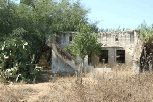
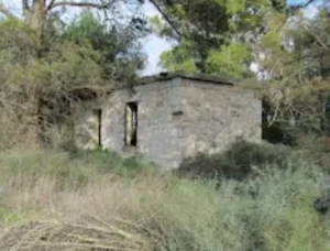
The village buildings were destroyed, and no major architectural landmarks remained at the site according to the field documentation relied upon by Walid Khalidi.
A few date-palm, carob, and fig trees survived.
The surrounding village lands were subsequently cultivated.
Khalidi's description reflects the condition of the site during his field documentation and should not necessarily be interpreted as a comprehensive survey updated to 2026.
Sources
- PalQuest – Interactive Encyclopedia of the Palestine Question: al-Jaladiyya.
- PalQuest: Operation An-Far.
- Palestine Remembered: al-Jaladiyya, Gaza District.
- Walid Khalidi, All That Remains: al-Jaladiyya, as reproduced by Palestine Remembered.
- Walid Khalidi, All That Remains, entry on al-Jaladiyya.
- Government of Palestine, censuses of 1922 and 1931.
- Government of Palestine, Department of Statistics, Village Statistics, 1945.
Photos from the village's people
Photos sent in by visitors and published after review.
Add a photo of this village
Log in to add photos of this village.
Other villages from Gaza
More from the archive


 Download Our Palestine App
The whole archive in the palm of your hand: depopulated villages, the Nakba, the massacres and Al-Aqsa — free, with no ads to erase the story.
Download Our Palestine App
The whole archive in the palm of your hand: depopulated villages, the Nakba, the massacres and Al-Aqsa — free, with no ads to erase the story.



Comments
No comments yet — be the first to write one.
Add your comment
Name and email are optional. Comments appear after review.