
The depopulated village of Yasur / District of Gaza
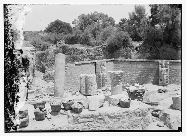
About the depopulated village of Yasur
- District
- Gaza
- Date Yasur was occupied
- 10 June 1948
- Population in 1948
- 1,241
- Military operation
- Operation Barak
- Brigade that carried it out
- Givati Brigade
- Distance from the governorate centre
- 40 km northeast of Gaza
- Elevation above sea level
- 50 m
- Cause of displacement
- Direct military assault by Israeli occupation forces to capture the village; the available sources do not detail how the inhabitants left
- Extent of destruction
- The village has been mostly destroyed with the exception of few deserted houses.
- Ethnic cleansing
- Yasur inhabitants were completely ethnically cleansed.
- Settlements built on the built-up area of Yasur after 1948
- Talmey Yechi'el (1949) and Bene Ayish (1958)
Hover a dot to read the village name, or click to open its card.
Borders of the depopulated village of Yasur
```html
- Subdistrict
- Gaza
- Distance from district center
- 40 km northeast of Gaza
- Average Elevation
- 50 m above sea level
- Population in 1931
- 654
- Number of Houses in 1931
- 129
- Population in 1944/1945
- 1,070
- Estimated Population in 1948
- About 1,241 – a later demographic estimate, not an official census
- Total Land Area in 1945
- 16,390 dunams
- Attack and Depopulation
- The First Battalion of the Giv'ati Brigade occupied the village on the night of 10–11 June 1948, just before the first truce took effect, in one of the small thrusts to capture individual villages or positions launched in the wake of Operation Barak, according to the History of the War of Independence as cited by Khalidi. The available sources do not detail what happened to its inhabitants when it was occupied.
- Final Israeli Control
- The night of 10–11 June 1948, just before the first truce took effect, according to the History of the War of Independence as cited by Khalidi
- Military Operation
- Operation Barak – PalQuest lists Yasur among the villages affected by it, but the village was captured in small thrusts launched in the wake of the operation, on the night of 10–11 June 1948
- Military Unit
- The First Battalion of the Giv'ati Brigade
- Cause of Depopulation
- Direct military assault by Israeli occupation forces to capture the village; the available sources do not detail how the inhabitants left
- Settlements Documented on Village Lands
- Talmey Yechi'el (1949) and Bene Ayish (1958)
Yasur: A Depopulated Palestinian Village in the Gaza District
Yasur was a depopulated Palestinian village in the Gaza District, located approximately 40 kilometers northeast of Gaza City on a low plateau in Palestine's coastal plain, at an average elevation of about 50 meters above sea level.
The Government of Palestine's 1944/1945 statistics recorded a population of 1,070 and a total land area of 16,390 dunums. During the Nakba and the occupation of Palestine in 1948, the First Battalion of the Giv'ati Brigade captured Yasur shortly before the First Truce. Walid Khalidi dates its capture to the night of 10–11 June 1948. Its Palestinian inhabitants were displaced and most of the village was subsequently destroyed.
Location of Yasur
- Yasur was located approximately 40 kilometers northeast of Gaza.
- Its average elevation was about 50 meters above sea level.
- The village stood on a plateau in Palestine's coastal plain.
- Secondary roads connected it with a main road leading southwest to al-Majdal and another leading northeast toward Ramla.
- Wadi al-Zurayq passed south of the village and formed part of the drainage system leading toward Wadi Suqrir.
Yasur Through History
During the Mamluk period, Yasur served as one of the postal stations on the route between Gaza and Damascus. The station was later transferred to the nearby village of Bayt Daras.
In 1596, Yasur was a village in the nahiya of Gaza within the liwa' of Gaza and had an estimated population of 303 according to Ottoman records cited by Walid Khalidi.
The inhabitants paid taxes on wheat, barley, fruit, and sesame, as well as goats, beehives, and buffaloes.
By the late nineteenth century, Yasur was described as a relatively densely built village. Its adobe houses stood close together and were separated by narrow, winding alleys, while extensive orchards lay to the north and east.
The Built Environment and Facilities of Yasur
The inhabitants of Yasur in the period immediately preceding the Nakba were predominantly Muslim. A mosque stood in the center of the village, along with several small shops and an elementary school.
The villagers relied on wells for domestic water and irrigation. Some of the wells used for agriculture ranged from approximately 25 to 40 meters in depth.
The built-up area covered about 35 dunums according to the 1944/1945 statistics.
Education in Yasur
An elementary school opened in Yasur in 1923. Walid Khalidi records that enrollment reached 132 pupils by the mid-1940s.
A separate educational table on Palestine Remembered gives a figure of 123 pupils in 1945. The sources therefore differ slightly on enrollment, while agreeing that the boys' school was established in 1923.
Land Ownership in Yasur
The total land area recorded for Yasur in the 1944/1945 statistics was 16,390 dunums.
The Arabic Palestine Remembered table uses the categories “Palestinian,” “Transferred to Zionists,” and “Masha'.” These terms are preserved below to reflect the terminology of that source. The Government of Palestine statistics, as reproduced by PalQuest, classify the corresponding categories as “Arab,” “Jewish,” and “Public.”
Land Ownership in Yasur, 1944/1945, Using the Terminology of Palestine Remembered
- Palestinian13,102 dunums80%
- Transferred to Zionists2,871 dunums18%
- Masha' / Communal417 dunums3%
Land Use in Yasur in 1944/1945
Most of Yasur's land was classified as cultivable. A total of 14,290 dunums was devoted to cereals, including 12,173 dunums of Arab land and 2,117 dunums of Jewish land.
Citrus and bananas covered 1,377 dunums, including 636 dunums of Arab land and 741 dunums of Jewish land. Plantations and irrigable land covered another 193 dunums, consisting of 180 dunums of Arab land and 13 dunums of Jewish land.
Land Use in Yasur According to the 1944/1945 Statistics
- Arab
- Jewish
- Public
- Citrus and Bananas1,377 dunums
- Plantations and Irrigable Land193 dunums
- Cereals14,290 dunums
- Built-up Area35 dunums
- Non-Cultivable Land495 dunums
Economic Life in Yasur
Agriculture formed the basis of Yasur's economy. The inhabitants cultivated cereals, citrus fruit, olives, and vegetables.
Cereal cultivation was largely rainfed, while citrus groves and vegetables were irrigated with water drawn from wells, some of which were between 25 and 40 meters deep.
Several small shops also operated in the village and served the everyday needs of its inhabitants.
Population of Yasur
The 1922 census recorded 456 inhabitants in Yasur. The population increased to 654 in the 1931 census, when 129 occupied houses were recorded.
The Government of Palestine's 1944/1945 statistics recorded 1,070 inhabitants.
The figures of 1,241 inhabitants for 1948 and 7,622 refugees for 1998 published by Palestine Remembered are later estimates and are not official Government of Palestine censuses.
Population of Yasur
- 1596303Historical figure based on Ottoman records
- 1922456Official census under the British Mandate
- 1931654Official census under the British Mandate
- 1944/19451,070Government of Palestine statistics
- 19481,241Estimate published by Palestine Remembered
- 19987,622Estimated refugee population published by Palestine Remembered
Number of Houses in Yasur
The 1931 census recorded 129 occupied houses in Yasur. The figure of 244 houses for 1948 published by Palestine Remembered is a later estimate rather than an official Government of Palestine census figure.
Number of Houses in Yasur
- 1931129Official census
- 1948244Estimate published by Palestine Remembered
Operation Barak and the Later Attack on Yasur
Operation Barak began on 9 May 1948 and was conducted primarily by the Giv'ati Brigade within the framework of Plan Dalet. It targeted villages and areas in the southern coastal plain and west of Ramla.
PalQuest lists Yasur among the villages affected by Operation Barak. However, Walid Khalidi's village entry makes clear that the attack that directly resulted in the capture of Yasur occurred later, as part of a series of smaller attacks carried out after Operation Barak and immediately before the First Truce.
The most precise formulation is therefore that Yasur's capture occurred in the continuation of military operations following Operation Barak rather than during the operation's principal phase in the first half of May.
The Occupation of Yasur and the Displacement of Its Inhabitants During the Nakba
According to Walid Khalidi and PalQuest, several villages and positions that remained outside Israeli control were targeted immediately before the First Truce. One of these attacks was directed at Yasur and carried out by the First Battalion of the Giv'ati Brigade.
Khalidi dates the capture of the village to the night of 10–11 June 1948, during the final hours before the First Truce took effect.
Palestine Remembered, by contrast, gives 9 June 1948 as the occupation date while likewise identifying the First Battalion of the Giv'ati Brigade as the attacking force. Because of this discrepancy, the night of 10–11 June is used here as the Khalidi/PalQuest date, while the alternative date is acknowledged as the account given by the second source.
The assault and occupation resulted in the displacement of Yasur's Palestinian population during the Nakba, and the inhabitants were prevented from returning to their homes and lands.
Occupation and Depopulation Chronology
- 9 May 1948
Beginning of the military operation
The Haganah launched Operation Barak, mainly with the Giv'ati Brigade and with the participation of the Palmach's Negev Brigade, to 'clear' the southern and western ends of its zone of control before 15 May; any villagers who remained in a village after its occupation were subject to expulsion, according to PalQuest, which lists Yasur among the villages affected by the operation. The available sources do not mention an attack on Yasur in May.
- Night of 10–11 June 1948
Final occupation
Just before the first truce took effect, many operations were planned for the one remaining night and most were implemented, among them an operation by the First Battalion of the Giv'ati Brigade to capture Yasur, according to the History of the War of Independence as cited by Khalidi. These small thrusts to capture individual villages or positions came in the wake of Operation Barak.
- 1949
Settlement on village lands
The settlement of Talmey Yechi'el was established on village lands.
- 1958
Settlement on village lands
The settlement of Bene Ayish was established on village lands.
Yasur and the Name Hatzor
An Israeli military account cited by Walid Khalidi states that Yasur was subsequently renamed “Hatzor.”
Khalidi, however, considers this likely to be a reference to Hatzor Ashdod, which had been founded in 1937 before the Nakba on land traditionally belonging to the Palestinian village of al-Batani al-Gharbi, more than two kilometers northwest of Yasur.
Hatzor Ashdod should therefore not be listed as a settlement established on Yasur's lands.
Settlements Established on the Lands of Yasur
Walid Khalidi identifies two Israeli settlements established on the lands of Yasur after the Nakba:
- Talmei Yehiel: established in 1949 on the lands of Yasur.
- Bnei Ayish: established in 1958 on the lands of Yasur.
People of Yasur After Displacement
Palestinian local documentation indicates that people from Yasur were dispersed after the Nakba across the Gaza Strip, Jordan, and other parts of the Palestinian diaspora.
In Jordan, descendants of the village established the Yasur Charitable Society in 2004. The society states that it was officially registered with the Jordanian Ministry of Social Development on 24 March 2004 to serve families originating from Yasur, strengthen social ties, and provide community assistance and development projects.
The Site of Yasur After the Nakba
According to Walid Khalidi's field description, the former village site became a closed and fenced military zone. A sign identifying an aircraft-parts industrial company stood near the entrance.
Khalidi recorded one undemolished house approximately ten meters from the entrance, with a demolished house and cactuses nearby.
A dirt road ran along the southern boundary of the fence, bordered by cactuses and olive and almond trees, while eucalyptus trees had been planted both inside and outside the fenced area.
This description is based on fieldwork conducted for Walid Khalidi's All That Remains and should not necessarily be treated as a field survey updated to the present day.
Sources
- PalQuestPalQuest – Interactive Encyclopedia of the Palestine Question: Yasur
- PalQuestPalQuest – Interactive Encyclopedia of the Palestine Question: Operation Barak
- Institute for Palestine StudiesInstitute for Palestine Studies: Walid Khalidi, All That Remains
- Palestine RememberedPalestine Remembered: Yasur – Gaza District
- Palestine RememberedPalestine Remembered: Yasur entry from All That Remains
- uasma.netYasur Charitable Society: About the Society and its establishment
Photo gallery


Photos from the village's people
Photos sent in by visitors and published after review.
Add a photo of this village
Log in to add photos of this village.
Other villages from Gaza
More from the archive


 Download Our Palestine App
The whole archive in the palm of your hand: depopulated villages, the Nakba, the massacres and Al-Aqsa — free, with no ads to erase the story.
Download Our Palestine App
The whole archive in the palm of your hand: depopulated villages, the Nakba, the massacres and Al-Aqsa — free, with no ads to erase the story.



Comments
No comments yet — be the first to write one.
Add your comment
Name and email are optional. Comments appear after review.