
The depopulated village of Tall al-Turmus / District of Gaza
Tall al-Turmus
About the depopulated village of Tall al-Turmus
- District
- Gaza
- Date Tall al-Turmus was occupied
- 09 July 1948
- Population in 1948
- 882
- Military operation
- Operation An-Far
- Distance from the governorate centre
- 38 (km) North East of Gaza
- Elevation above sea level
- 75 m
- Cause of displacement
- Expulsion by Zionist troops
- Extent of destruction
- The village has been completely destroyed, and only house rubble left behind.
- Ethnic cleansing
- Tall al-Turmus inhabitants were completely ethnically cleansed.
- Settlements built on the built-up area of Tall al-Turmus after 1948
- Gogoret, Temorem
Hover a dot to read the village name, or click to open its card.
Borders of the depopulated village of Tall al-Turmus
Tall al-Turmus – Depopulated Palestinian Village of the Gaza District
Tall al-Turmus was a depopulated Palestinian village in the Gaza District. It stood on a low hill on the southern coastal plain, approximately 38 kilometers northeast of Gaza, at an average elevation of about 75 meters above sea level.
The village was occupied and its inhabitants displaced during the Nakba and the 1948 occupation of Palestine. Walid Khalidi considers it most likely that Tall al-Turmus fell around 9–10 July 1948, early in Operation An-Far, to the First Battalion of the Giv'ati Brigade.
Location and Geography
Tall al-Turmus stood on a low hill on the coastal plain. Wadi Marj ran along its southern perimeter, while secondary roads connected the village with nearby communities and with a main road leading southwest toward al-Majdal.
The village lay approximately 38 kilometers northeast of Gaza and had an average elevation of about 75 meters above sea level.
Its lands adjoined those of several villages, including Qastina, al-Masmiyya al-Saghira, Tall al-Safi, Bi'lin, Summil, al-Jaladiyya, and al-Sawafir al-Sharqiyya. Qastina was particularly close, approximately 1.5 kilometers northwest of Tall al-Turmus.
Name and Establishment
The name Tall al-Turmus combines tall, referring to the low hill on which the village stood, and turmus, the Arabic name for lupine, a plant associated with the surrounding area.
According to village residents whose account was recorded by Walid Khalidi, Tall al-Turmus had been established more than a century before the period in which its history was documented, placing the formation of its modern settlement at least in the nineteenth century.
The earliest houses clustered on the hill itself. As the village expanded, construction spread eastward and westward beyond the original nucleus. Most houses were built of adobe.
Population and Houses
The inhabitants of Tall al-Turmus were Muslims. The population increased considerably during the British Mandate period.
- 1922384Official Mandate census; all inhabitants were Muslims
- 1931504Official census; this is the supported figure rather than 540 shown in one online table
- 1945760Official statistics; all inhabitants were Palestinian Arab Muslims
- 1948About 882Later estimate, not an official British census
- 1998About 5,414 refugees and descendantsLater estimate published by Palestine Remembered
The 1931 census recorded 136 houses. The figure of approximately 222 houses for 1948 published by Palestine Remembered is a later estimate rather than an official Mandate census count.
Built Environment and Mosque
The official 1944/45 statistics classified approximately 35 dunams as built-up land. Houses were initially concentrated on the hill and later expanded east and west as the population grew.
Tall al-Turmus had a mosque serving its Muslim inhabitants. Walid Khalidi's village entry does not document a church, and the population is consistently described as Muslim. An unsupported church entry appearing in one online statistical table has therefore not been treated as established information.
Education
Tall al-Turmus did not have an independent school. Instead, it shared an elementary school with neighboring Qastina. The school was established in Qastina in 1936.
The Tall al-Turmus entry in PalQuest records approximately 160 pupils in the shared school by the mid-1940s, while the Qastina entry gives 161. The one-student difference is minor and may reflect a difference in reporting or enrollment date.
Water Resources
The principal sources reviewed do not provide a detailed account of Tall al-Turmus's domestic water system or a list of named wells and springs.
Walid Khalidi records a nearby khirba containing an old well. Palestinian documentation also refers to an ancient well within the archaeological area. This establishes the presence of the well, but the available evidence is insufficient to reconstruct the village's complete domestic or agricultural water network.
Economic Life and Agriculture
Agriculture formed the backbone of the economy. Villagers cultivated cereals, vegetables, and fruit, and a very large proportion of the village lands was classified as cultivable.
In 1944/45, 154 dunams were devoted to citrus and bananas and 627 dunams to plantations and irrigable land. The total cereal area was 10,403 dunams when Arab, Jewish, and public land categories are combined.
Palestine Remembered also gives a crop-specific figure of approximately 158 dunams planted with olives. This figure should not be added again to the overall land-use total because olive cultivation falls within the broader agricultural categories.
Land Ownership, 1944/45
The total land area of Tall al-Turmus was 11,508 dunams. Under the official Government of Palestine classification, ownership was distributed as follows:
- Arab11,199 dunums97%
- Jewish68 dunums<1%
- Public241 dunums2%
Palestine Remembered presents the same figures using its simplified terminology: 11,199 dunams “Palestinian,” 68 dunams “Transferred to Zionists,” and 241 dunams “Communal/Public.” “Transferred to Zionists” has been retained because it reflects that source's terminology and should not be silently replaced with “Jewish ownership.”
Land Use, 1944/45
- Arab
- Jewish
- Public
- Cereals10,403 dunums
- Plantations and irrigable land627 dunums
- Citrus and bananas154 dunums
- Total cultivable/cultivated land11,184 dunums
- Non-cultivable land289 dunums
- Built-up land35 dunums
- Total non-cultivable and built-up324 dunums
The official table balances exactly: 11,184 dunams of cultivable or cultivated land plus 324 dunams of non-cultivable and built-up land equal the village's total area of 11,508 dunams.
Some simplified online tables require correction. The 7 public dunams planted with cereals should remain in the Public category rather than being combined with Palestinian privately held land. Likewise, 234 of the 289 non-cultivable dunams were classified as Public in the official table.
Archaeological Site and Khirba
A khirba containing an old well lay next to Tall al-Turmus. Palestine Remembered identifies an archaeological locality known as Khirbat al-Taratir and records pottery remains and an old well.
The principal sources do not provide sufficient archaeological dating to assign all of these remains securely to a particular historical period.
Operation An-Far
Operation An-Far began on 8 July and ended on 15 July 1948. It was carried out by the First Battalion of the Giv'ati Brigade on the southern front during the Ten Days between the two truces.
The operation was designed to expand Giv'ati's zone of control to the south and east and to attempt to connect the occupied coastal area with Jewish settlements in the Negev. The operational orders also called for civilians to be expelled from areas occupied during the offensive.
Egyptian forces partially blocked the advance on parts of the front, but the operation resulted in the occupation and depopulation of numerous Palestinian villages around the meeting point of the Gaza, Hebron, and Ramla districts. PalQuest explicitly lists Tall al-Turmus among the villages affected by Operation An-Far.
Occupation and Depopulation
The principal sources do not establish a single completely certain day for the occupation of Tall al-Turmus. Palestine Remembered indexes the date as 9 July 1948, while Walid Khalidi states that the village probably fell early in Operation An-Far, around 9–10 July.
The force identified with the village's occupation was the First Battalion of the Giv'ati Brigade, the same battalion that conducted Operation An-Far.
PalQuest, through the sources used in Khalidi's account, records that the First Battalion's operational orders called for the expulsion of civilians from occupied territory. Giv'ati sources later claimed, by contrast, that villagers had fled before the advancing forces reached their communities.
For Tall al-Turmus specifically, Khalidi suggests that its inhabitants may have been among a group from the area who were driven through an Israeli-held strip toward Gaza rather than fleeing east toward Hebron. Because the source presents this as a probability rather than a certainty, the route of displacement should not be treated as conclusively established for every resident.
Occupation Chronology
- 8 July 1948
Beginning of Operation An-Far
The First Battalion of the Giv'ati Brigade launched the offensive on the southern front to expand Giv'ati control southward and eastward.
- Probably 9–10 July 1948
Occupation of Tall al-Turmus
Khalidi places the village's fall in the opening phase of Operation An-Far. Palestine Remembered indexes the occupation to 9 July.
- During the occupation, approximately 9–10 July 1948
Depopulation
Khalidi suggests that inhabitants of Tall al-Turmus may have been among those driven through Israeli-held territory toward Gaza.
- 15 July 1948
End of Operation An-Far
The operation ended after the occupation and depopulation of numerous villages south of Ramla and between the coastal plain and the Hebron hills.
- Exact date not documented
Destruction of village buildings
The principal sources do not give a securely documented date for the destruction of Tall al-Turmus's buildings.
- 1954
Establishment of Timmorim on village land
Timmorim was established on land belonging to Tall al-Turmus.
Military Unit
The available sources identify the First Battalion of the Giv'ati Brigade as the force that most probably occupied Tall al-Turmus during the opening phase of Operation An-Far.
In this case, the evidence is sufficiently specific to identify not only the brigade but also the battalion associated with the village's occupation.
Israeli Settlements on Village Lands
Timmorim was established on the lands of Tall al-Turmus in 1954.
Walid Khalidi specifically identifies Timmorim as the settlement established on village land. Nearby Israeli localities should therefore not be added to this section unless there is separate documentation demonstrating that they lie within Tall al-Turmus's cadastral lands.
Tall al-Turmus Today
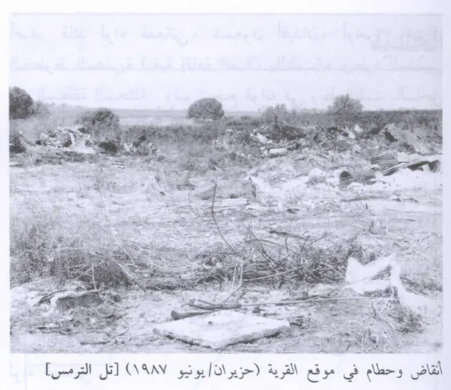
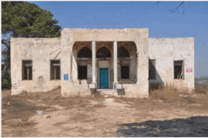
According to the field description published in Walid Khalidi's All That Remains, rubble from the village houses was scattered across the site. Clumps of cactus and sycamore and eucalyptus trees grew nearby, while surrounding lands were cultivated by Israeli farmers.
This description is not a field verification of conditions at the site in 2026. Field research for the All That Remains project was carried out between 1987 and 1990. The description therefore records the site's condition during that research period, and the principal sources reviewed here do not provide a comprehensive contemporary field survey of all surviving remains.
Sources
- PalQuest – Interactive Encyclopedia of the Palestine Question: Tall al-Turmus
- PalQuest – Operation An-Far
- PalQuest – Qastina; shared school information
- Palestine Remembered – Tall al-Turmus, Gaza District
- Palestinian Encyclopedia – Tall al-Turmus
- Institute for Palestine Studies – Walid Khalidi, All That Remains
- PalQuest – All That Remains: Methodology
Photo gallery

Photos from the village's people
Photos sent in by visitors and published after review.
Add a photo of this village
Log in to add photos of this village.
Other villages from Gaza
More from the archive


 Download Our Palestine App
The whole archive in the palm of your hand: depopulated villages, the Nakba, the massacres and Al-Aqsa — free, with no ads to erase the story.
Download Our Palestine App
The whole archive in the palm of your hand: depopulated villages, the Nakba, the massacres and Al-Aqsa — free, with no ads to erase the story.



Comments
No comments yet — be the first to write one.
Add your comment
Name and email are optional. Comments appear after review.