
The depopulated village of Al-Kafrayn / District of Haifa
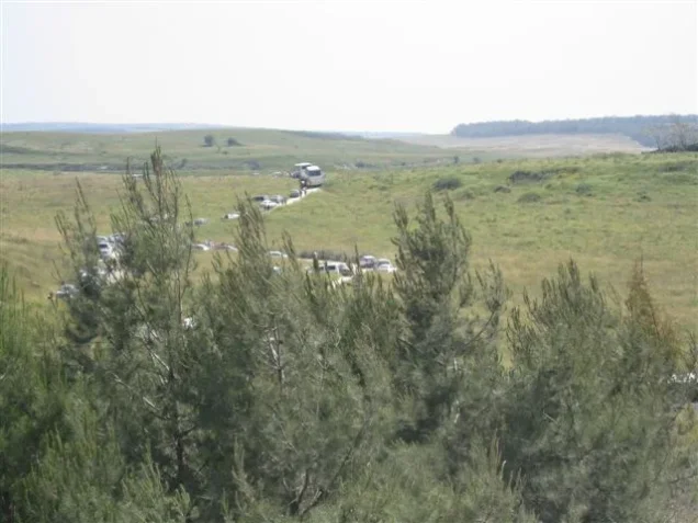
Al-Kafrayn
About the depopulated village of Al-Kafrayn
- District
- Haifa
- Date Al-Kafrayn was occupied
- 12 April 1948
- Population in 1948
- 1,070
- Military operation
- The Battle of Mishmar ha-'Emeq
- Brigade that carried it out
- The Carmeli Brigade
- Who defended the village
- Arab Liberation Army
- Distance from the governorate centre
- 29.5 (km) South East of Haifa
- Elevation above sea level
- 250 m
- Cause of displacement
- Military assault by Zionist troops
- Extent of destruction
- On the 19th of April 1948, the village was completely obliterated.
- Ethnic cleansing
- al-Kafrayn inhabitants were completely ethnically cleansed.
Hover a dot to read the village name, or click to open its card.
Borders of the depopulated village of Al-Kafrayn
Al-Kafrayn – Depopulated Palestinian Village in Haifa Subdistrict
Al-Kafrayn was a Palestinian village in the Haifa subdistrict. It stood approximately 29.5 kilometers southeast of Haifa at an average elevation of about 250 meters above sea level.
The village was built on a hilltop surrounded by shallow wadis separating long, gently sloping hills. It lay approximately six kilometers north of Wadi 'Ara, and a secondary road led northwest from the village to the Haifa–Jenin highway along the edge of Marj Ibn 'Amir.
Al-Kafrayn had an official population of 920 in 1944/45 and a registered land area of 10,882 dunums.
The Haganah announced the capture of Al-Kafrayn on 12 April 1948 during the counteroffensive launched against Palestinian villages around Mishmar ha-'Emeq after the battle there. Khalidi's account describes the attack on Al-Kafrayn as a Palmach attack. Part of the village was destroyed during the capture, while complete demolition was delayed for approximately a week so that the Palmach could use the remaining buildings for training in urban combat.
Key Facts about Al-Kafrayn
| Field | Information |
|---|---|
| Name | Al-Kafrayn |
| Subdistrict | Haifa |
| Distance from Haifa | Approximately 29.5 km southeast |
| Average elevation | Approximately 250 m above sea level |
| Population, 1931 | 657 in 95 houses – the figure includes al-Balawina according to Khalidi and PalQuest |
| Population, 1944/45 | 920 |
| Registered land area | 10,882 dunums |
| Occupation date | 12 April 1948; Arab Liberation Army records note a withdrawal from immediately west of the village on 13 April |
| Military context | The Haganah/Palmach counteroffensive following the Battle of Mishmar ha-'Emeq |
| Military unit | Palmach forces; no village-specific battalion is identified in Khalidi's entry |
| Defenders | Arab Liberation Army forces in the surrounding area |
| Cause of depopulation | Military assault and occupation during the counteroffensive around Mishmar ha-'Emeq |
| Destruction | Partial destruction during occupation, followed by complete demolition after urban-combat exercises; the Haganah General Staff was informed on 19 April |
| Israeli settlements on village land | No civilian Israeli settlement is documented on village land; part of the land became a military training area |
Name of the Village
Al-Kafrayn means “the two villages” in Arabic, using the dual form of the word kafr, meaning village.
During the Crusader period the locality was known as Caforana.
The principal sources do not provide a detailed historical explanation identifying the two specific settlements or nuclei that gave rise to the Arabic dual form, so no more precise origin has been inferred.
Location
Al-Kafrayn stood in Bilad al-Rawha, among the hills between Marj Ibn 'Amir and Wadi 'Ara.
It occupied a hilltop surrounded by shallow wadis and gently sloping terrain.
The village was approximately six kilometers north of Wadi 'Ara.
A secondary road ran northwest to the Haifa–Jenin highway, which bordered Marj Ibn 'Amir.
Nearby Palestinian communities included Abu Shusha, Daliyat al-Rawha', al-Rihaniyya, al-Mansi, Umm al-Shawf, al-Butaymat, and al-Lajjun.
Geography and Wadis
The Palestinian Encyclopedia places Al-Kafrayn within the Carmel highlands and notes that upper tributaries of the Zarqa River began near the village.
Nearby watercourses included Wadi 'Ayn Hamad and Wadi Khallat Abu Nimr, which passed northwest of the village and joined smaller channels to form Wadi al-Dafla.
The abundance of wadis, springs, and wells supported both agriculture and livestock raising.
Al-Kafrayn in the Nineteenth Century
In 1859 the population was estimated at approximately 200, with around 30 feddans under cultivation.
The Survey of Western Palestine described Al-Kafrayn in 1882 as a moderately sized village on the western side of the watershed with a spring on that side.
A late nineteenth-century population list recorded substantial population growth before the beginning of the British Mandate period.
Village Layout and Buildings
Al-Kafrayn had an approximately rectangular layout with its long axis running east to west.
Its houses were relatively compact and were constructed of stone and cement or stone and mud; Khalidi also refers to mud-and-cement construction.
In 1944/45 approximately 18 dunums were classified as built-up land.
The village contained a mosque, an elementary boys' school, springs, wells, and agricultural plots surrounding the built-up center.
Population
- 1922571Official census: 569 Muslims and 2 Orthodox Christians
- 1931657Official census in 95 houses; Khalidi and PalQuest state that the figures include al-Balawina
- 1944/45920Official Village Statistics; the Palestinian Encyclopedia states that Arab al-Balawina were included in this total
- 19481,067Later Palestine Remembered estimate, not an official census
- 19986,554Later estimate of refugees and descendants reported by Palestine Remembered
Particular caution is required with the 1931 figure because Khalidi and PalQuest explicitly state that both the 657 population total and 95 houses include al-Balawina.
The Palestinian Encyclopedia also states that Arab al-Balawina were included in the 1945 population total, although PalQuest's footnote is attached explicitly only to the 1931 line. This difference in source presentation is therefore preserved rather than inventing a separate Al-Kafrayn-only figure.
Number of Houses
- 193195Official census figure, including al-Balawina according to Khalidi and PalQuest
- 1948154Later Palestine Remembered estimate, not an official house census
Land Ownership in Al-Kafrayn
The total registered village land area in 1944/45 was 10,882 dunums.
- Palestinian9,981 dunums92%
- Transferred to Zionists0 dunums0%
- Communal/Public901 dunums8%
The figures balance exactly: 9,981 + 0 + 901 = 10,882 dunums.
The original official categories were 9,981 Arab dunums, no Jewish-owned land, and 901 Public dunums.
Land Use in 1944/45
- Arab
- Public
- Cereals9,911 dunums
- Plantations and irrigable land147 dunums
- Built-up land18 dunums
- Non-cultivable land806 dunums
The land-use figures balance exactly:
9,776 + 135 + 147 + 18 + 40 + 766 = 10,882 dunums.
Some simplified displays place all 9,911 dunums of cereal land under a Palestinian heading. The official breakdown, however, consists of 9,776 Arab dunums and 135 Public dunums.
Likewise, the 806 dunums of non-cultivable land consist of 40 Arab dunums and 766 Public dunums.
Olive Cultivation
The Palestinian Encyclopedia records approximately 30 dunums planted with olives west and northwest of the village during the 1942/43 agricultural season, about half of which were productive.
Because this figure belongs to an earlier agricultural season, it is retained as separate historical information rather than being added arithmetically to the 147 dunums classified as plantations and irrigable land in 1944/45.
Economic Life
Al-Kafrayn's economy rested primarily on agriculture and livestock raising.
Grain, especially wheat, was the principal crop.
The 1944/45 statistics show the dominance of cereal cultivation: 9,776 Arab dunums and a further 135 Public dunums were devoted to grain.
Another 147 dunums were irrigated or used for orchards, while olive cultivation and cattle raising formed additional components of village economic life.
Water Resources
Al-Kafrayn was relatively rich in springs and wells. Khalidi records approximately ten water sources within the village lands.
The Palestinian Encyclopedia names several of them, including:
- 'Ayn al-Safsafa.
- 'Ayn al-Kafrayn.
- 'Ayn al-Balad.
- 'Ayn Qasim.
- 'Ayn al-Za'tara.
- 'Ayn 'Abbas.
- 'Ayn al-Fart.
- 'Ayn Faris.
- 'Ayn al-Ras.
Two additional wells lay northwest of the village, while Bir al-Lubayda was approximately 1.5 kilometers away.
'Ayn al-Kafrayn was particularly important for drinking and household water.
Education
Al-Kafrayn had an elementary boys' school established around 1888 during the Ottoman period.
This made it one of the relatively early rural schools in the area.
Community archival material preserved by Palestine Remembered includes documents concerning teacher appointments at the school in 1928–1930 and 1935–1937, as well as another appointment dated December 1947. These records reinforce the evidence that the school remained active until very late in the Mandate period.
The principal sources reviewed do not provide a securely documented pupil enrollment immediately before the Nakba, so no unsupported total has been added.
The Mosque
Al-Kafrayn had a mosque serving its predominantly Muslim population.
Khalidi does not provide a detailed architectural description or a securely documented construction date.
The presence of two Orthodox Christians in the 1922 census is not sufficient evidence for a separate church building. The principal village sources document a mosque and school but do not independently document a church.
Archaeological Remains
Al-Kafrayn contained several older ruins reflecting the long history of settlement at the site.
Khalidi records building foundations and tombs, while other documentation mentions additional architectural stones and columns.
The village entry does not provide secure archaeological dating for all these remains, so they have not been assigned collectively to a single historical period.
The Battle of Mishmar ha-'Emeq and the Military Context
The Battle of Mishmar ha-'Emeq began on 4 April 1948 when the Arab Liberation Army attacked the Jewish settlement of Mishmar ha-'Emeq.
After the Arab Liberation Army offensive stalled, a British-mediated ceasefire was proposed. The Haganah leadership rejected the proposal and instead launched a broad counteroffensive against Palestinian villages surrounding the settlement.
Approximately ten villages were targeted, including Al-Kafrayn, which contemporary reporting described as the largest of the villages selected for attack.
The most precise description is therefore not a formally named “Operation Mishmar ha-'Emeq,” but rather the Haganah and Palmach counteroffensive following the Battle of Mishmar ha-'Emeq.
Occupation and Depopulation
The Haganah announced the capture of Al-Kafrayn on 12 April 1948.
On 13 April, Arab Liberation Army records noted the withdrawal of Arab forces from an area immediately west of the village.
Khalidi describes the attack on Al-Kafrayn as a Palmach attack forming part of the counteroffensive launched after the Battle of Mishmar ha-'Emeq.
The New York Times, citing a Haganah broadcast on 12 April, reported that Al-Kafrayn was the fifth village around Mishmar ha-'Emeq to be occupied by Haganah forces.
12 April is therefore used as the occupation date, while the Arab withdrawal west of the village is separately recorded for the following day.
Attacking Military Unit
Some simplified Palestine Remembered metadata list the Carmeli Brigade as a possible attacking unit.
The detailed historical narrative reproduced from Khalidi, however, specifically describes the attack on Al-Kafrayn as a Palmach attack during the post-Mishmar ha-'Emeq counteroffensive.
No specific Palmach battalion is identified in the village entry. No other brigade or battalion has therefore been assigned as the direct village-level attacking unit without separate evidence.
Cause of Depopulation
Al-Kafrayn's population was displaced as a direct consequence of the military assault and occupation during the Haganah counteroffensive against the villages around Mishmar ha-'Emeq.
Palestine Remembered classifies the cause as direct military assault.
Khalidi emphasizes the occupation and the decision to attack and destroy the surrounding villages but does not provide a separate family-by-family account of the inhabitants' departure.
Ethnic Cleansing
Palestine Remembered characterizes the final outcome at Al-Kafrayn as complete ethnic cleansing.
Khalidi's documented sequence establishes the capture and complete depopulation of the village, partial demolition at the time of occupation, and its subsequent total destruction.
The term “ethnic cleansing” is therefore retained as an attributed characterization used by Palestine Remembered, while the directly documented facts are the disappearance of Al-Kafrayn's Palestinian community and the deliberate destruction of the village after its capture.
Destruction of Al-Kafrayn
Al-Kafrayn was not completely demolished at the moment of occupation.
According to the account reproduced by Khalidi, part of the village was destroyed during its capture, while final demolition was delayed for approximately one week because the Palmach intended to use the remaining buildings to train units in fighting within built-up areas.
Company-level urban-combat exercises were conducted around 18 April.
On 19 April the Haganah General Staff was informed that the exercises had ended and that Al-Kafrayn had been completely blown up.
The occupation date of 12 April must therefore be distinguished from the village's complete demolition around 18–19 April.
Occupation Chronology
- 4 April 1948
Beginning of the Battle of Mishmar ha-'Emeq
The Arab Liberation Army launched an attack on Mishmar ha-'Emeq.
- After the Arab offensive stalled
Rejection of ceasefire and counteroffensive
The Haganah leadership launched attacks against surrounding Palestinian villages.
- 12 April 1948
Occupation of Al-Kafrayn
The Haganah announced the village's capture; Khalidi describes the attack as a Palmach attack.
- 13 April 1948
Arab withdrawal west of Al-Kafrayn
Arab Liberation Army records note the withdrawal of forces from immediately west of the village.
- During the capture
Partial destruction
Part of the village was destroyed, while some buildings were retained temporarily for military training.
- About 18 April 1948
Urban-combat exercises
Remaining village buildings were used for training in fighting inside built-up areas.
- 18–19 April 1948
Complete demolition
The village was completely blown up after the exercises; the Haganah General Staff was informed on 19 April.
Israeli Settlements on Al-Kafrayn's Lands
Khalidi and PalQuest identify no civilian Israeli settlement as having been established on Al-Kafrayn's village lands.
Part of the village land was, however, subsequently used as a military training camp.
Nearby settlements should not be attributed to Al-Kafrayn simply because of geographic proximity.
Al-Kafrayn Today
According to Walid Khalidi's field description, the former village site and its surrounding lands were divided between a military training camp and cattle pasture.
A rubble-filled area had been fenced off and was covered with soil, underbrush, and thorny vegetation.
Almond, olive, and fig trees remained scattered around the site.
This account derives from fieldwork undertaken before the publication of All That Remains in 1992 and should therefore be treated as a documented historical site description rather than comprehensive direct field verification of conditions in 2026.
Palestine Remembered contains later community documentation, including oral-history interviews, visits to 'Ayn al-Kafrayn, and photographs from a 2025 field visit. These provide useful later documentation of memory and individual surviving features but do not constitute a comprehensive independent archaeological or cadastral survey of all village lands.
Sources
- PalQuest – Interactive Encyclopedia of the Palestine Question: Al-Kafrayn
- Palestine Remembered – Al-Kafrayn, Haifa District
- Walid Khalidi – All That Remains: Al-Kafrayn
- Palestinian Encyclopedia – Al-Kafrayn, drawing on Mustafa Murad al-Dabbagh
- Government of Palestine – Census of Palestine 1922
- Government of Palestine – Census of Palestine 1931
- Sami Hadawi – Village Statistics 1945
- Institute for Palestine Studies – All That Remains, Walid Khalidi
- Palestine Remembered – Al-Kafrayn School Teacher Appointment Documents, 1928–1930
- Palestine Remembered – Al-Kafrayn School Documents, 1935–1937
Photo gallery


Photos from the village's people
Photos sent in by visitors and published after review.
Add a photo of this village
Log in to add photos of this village.
Other villages from Haifa
More from the archive



 Download Our Palestine App
The whole archive in the palm of your hand: depopulated villages, the Nakba, the massacres and Al-Aqsa — free, with no ads to erase the story.
Download Our Palestine App
The whole archive in the palm of your hand: depopulated villages, the Nakba, the massacres and Al-Aqsa — free, with no ads to erase the story.



Comments
No comments yet — be the first to write one.
Add your comment
Name and email are optional. Comments appear after review.