
The depopulated village of Umm al-Shawf / District of Haifa
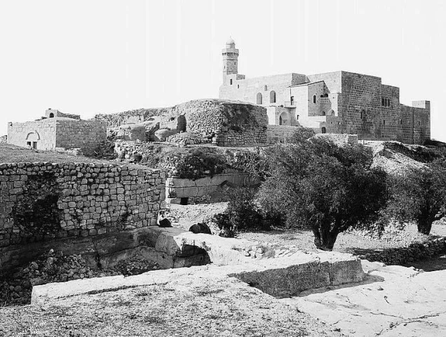
Umm al-Shawf
About the depopulated village of Umm al-Shawf
- District
- Haifa
- Date Umm al-Shawf was occupied
- 12 May 1948
- Population in 1948
- 557
- Brigade that carried it out
- The Irgun, according to the Israeli military intelligence report of 30 June 1948 as published by PalQuest
- Who defended the village
- Local Palestinian militia and Arab Liberation Army volunteers.
- Distance from the governorate centre
- 29.5 km south of Haifa
- Elevation above sea level
- 125 m
- Cause of displacement
- Direct military assault by Zionist forces: the occupation of the village by the Irgun, according to the Israeli military intelligence report
- Extent of destruction
- The village has been completely obliterated with the exception of its shrine.
- Ethnic cleansing
- Massacre occured by Zionist troops against the town's inhabitants.
- Settlements built on the built-up area of Umm al-Shawf after 1948
- Giv'at Nili, founded in 1953 on village lands south of the village site
Hover a dot to read the village name, or click to open its card.
Borders of the depopulated village of Umm al-Shawf
Umm al-Shawf – A Depopulated Palestinian Village in the Haifa Subdistrict
Umm al-Shawf was a Palestinian village in the Haifa Subdistrict, located approximately 29.5 km south of Haifa. It stood on the gently sloping southern section of Wadi al-Marah in Bilad al-Rawha, at an average elevation of about 125 meters above sea level.
The village was depopulated during the Nakba and the occupation of Palestine in 1948, in the course of an Irgun assault on several villages of Bilad al-Rawha in May 1948. Sources differ on the precise occupation date. Palestine Remembered gives 12 May, while an Israeli military intelligence report dated 30 June 1948 and published by PalQuest records Umm al-Shawf as having been occupied by the Irgun on 14 May. The attack and occupation are therefore best dated to the period 12–14 May 1948 while preserving the discrepancy between the sources.
- Subdistrict
- Haifa
- Distance from Haifa
- 29.5 km south of Haifa
- Elevation
- 125 m above sea level
- Population in 1931
- 325
- Number of Houses in 1931
- 73
- Physical setting
- Wadi al-Marah in Bilad al-Rawha
- Population, 1944/45
- 480
- Estimated population, 1948
- About 557 – a later demographic estimate, not an official census
- Occupation and depopulation
- 12–14 May 1948; sources differ on the precise day
- Military force
- Irgun (IZL/Etzel); Palestine Remembered also notes possible participation by other forces
- Total land area
- 7,426 dunams
- Attack and Depopulation
- Irgun forces occupied the village and all its inhabitants left on 14 May 1948, heading towards Rummana and Umm al-Fahm, according to the Israeli military intelligence report dated 30 June 1948 as published by PalQuest.
- Final Israeli Control
- 12 or 14 May 1948: the archive's record, taken from Palestine Remembered, gives 12 May, and the Israeli military intelligence report of 30 June 1948, as published by PalQuest, gives 14 May; Khalidi's entry on PalQuest carries no text on the village's occupation
- Military Unit
- The Irgun, according to the Israeli military intelligence report dated 30 June 1948 as published by PalQuest
- Cause of Depopulation
- Direct military assault by Zionist forces: the occupation of the village by the Irgun, according to the Israeli military intelligence report
- Settlements Documented on Village Lands
- Giv'at Nili, founded in 1953 on village lands south of the village site
- Israeli settlement on village land
- Giv'at Nili, established in 1953
Location and Geography of Umm al-Shawf
Umm al-Shawf stood on the gently sloping southern part of Wadi al-Marah in the Bilad al-Rawha region and faced north. Secondary roads linked it with the coastal highway, the Haifa–Jenin road, and neighboring Palestinian villages.
In the late nineteenth century, Umm al-Shawf was a small village extending generally from southeast to northwest. Two springs located north of the village supplied its inhabitants with water.
Neighboring Villages
Maps and locality information preserved by Palestine Remembered place the neighboring communities approximately as follows:
- Northwest: Sabbarin.
- Northeast: Daliyat al-Rawha.
- East: Khubbayza.
- Southeast: Qannir.
- South: Kafr Qari'.
- West: al-Sindiyana.
These directions describe the approximate geographical position of neighboring communities and should not be treated as substitutes for detailed cadastral boundary maps.
Built Form of Umm al-Shawf
The houses of Umm al-Shawf were constructed of stone and mud or stone and cement. The village's built-up area generally extended along a southeast–northwest axis.
The village contained a mosque and a shrine dedicated to a local holy man identified by Walid Khalidi as Shaykh Abd Allah. The shrine later became one of the most recognizable surviving structures at the village site.
Population of Umm al-Shawf
The population was estimated at approximately 150 in the mid-nineteenth century, and the inhabitants were Muslims.
The official 1922 Census of Palestine recorded 252 Muslims in Umm al-Shawf. The official 1931 census recorded 325 inhabitants—159 males and 166 females—all Muslims, living in 73 occupied houses.
Some modern secondary pages incorrectly reproduce the 1931 population as 353. The original official census table, however, clearly records 325, and that figure is therefore used here.
The 1944/45 statistics recorded a population of 480. Palestine Remembered later estimated the village population at 557 in 1948 and the number of refugees and their descendants at 3,419 in 1998. These latter figures are retrospective estimates rather than official Mandate census counts.
- Mid-19th centuryApproximately 150Historical estimate
- 1922252Official census; all Muslims
- 1931325Official census; 159 males and 166 females, all Muslims
- 1944/45480Official British Mandate statistics
- 1948557Later estimate reported by Palestine Remembered, not an official census
- 19983,419 refugeesLater estimate of refugees and their descendants
Number of Houses
- 193173Occupied houses recorded in the official census
- 1948125Later estimate reported by Palestine Remembered
Land Ownership in Umm al-Shawf
The total land area of Umm al-Shawf in the 1944/45 statistics was 7,426 dunums. Palestine Remembered presents the simplified ownership categories as follows:
- Palestinian6,320 dunums85%
- Transferred to Zionists0 dunums0%
- Communal/Public1,106 dunums15%
The detailed official categories reproduced by PalQuest classify 6,320 dunums as Arab and 1,106 dunums as Public. No land is recorded under the Jewish category.
Land Use in 1944/45
- Arab
- Public
- Cereals6,177 dunums
- Plantations and irrigable land107 dunums
- Built-up land31 dunums
- Non-cultivable land1,111 dunums
A total of 6,284 dunums were classified as cultivable: 6,282 Arab dunums and 2 public dunums. The built-up area covered another 31 dunums.
Non-cultivable land totaled 1,111 dunums, consisting of 7 Arab dunums and 1,104 public dunums. The full 1,111-dunum figure should therefore not be treated as privately Palestinian-owned land.
Khalidi notes that 32 dunums were planted with olive trees. These 32 dunums were part of the 107 dunums classified as plantations and irrigable land and should not be added again when calculating the village's total cultivated acreage.
Economic Life in Umm al-Shawf
Agriculture and the raising of animals and poultry formed the principal basis of village life. Cereals and olives were among the most important crops.
In 1944/45, 6,175 Arab dunums were devoted to cereals, together with 2 public dunums, for an overall cereal total of 6,177 dunums.
Plantations and irrigable land covered 107 dunums, including 32 dunums planted with olive trees. These figures demonstrate the dominant role of cereal cultivation in the village economy.
Water
Umm al-Shawf had access to local spring water. Khalidi records that two springs north of the village supplied the inhabitants with water.
The village's location in Wadi al-Marah formed part of the natural environment of Bilad al-Rawha, and its springs supported household and agricultural needs.
Mosque and the Shrine of Shaykh Abd Allah
Umm al-Shawf had a mosque as well as a shrine dedicated to a local holy man identified by Khalidi as Shaykh Abd Allah.
Later local accounts associate the surviving shrine with Shaykh Muhyi al-Din al-Awatla. Since Khalidi's principal village entry identifies it as the shrine of Shaykh Abd Allah, that name is retained here, while the alternative identification is treated as local historical memory requiring independent corroboration.
Education and Services
The principal sources used for this article do not provide sufficiently documented information about a formal school in Umm al-Shawf, its founding date, or pupil numbers. Unsupported educational details have therefore not been added.
Occupation and Depopulation of Umm al-Shawf in 1948
The occupation of Umm al-Shawf formed part of the May 1948 assault on Palestinian villages in Bilad al-Rawha. Palestinian sources discussing this campaign state that Irgun units mobilized against a group of villages including Burayka, al-Sindiyana, Sabbarin, Khubbayza, and Umm al-Shawf.
The precise date differs between sources. Palestine Remembered gives 12 May 1948 as the occupation date, corresponding with the date commonly given for the assault on several neighboring villages.
By contrast, an Israeli military intelligence report dated 30 June 1948 and published and contextualized by PalQuest records 14 May 1948 for Umm al-Shawf. The report states that the entire population had left, that the village was occupied by the Irgun, and that inhabitants went toward Rummana and Umm al-Fahm.
The most accurate formulation is therefore that the attack, occupation, and depopulation of Umm al-Shawf occurred during 12–14 May 1948, with 12 May reported by Palestine Remembered and 14 May recorded in the contemporary intelligence document published by PalQuest.
Palestine Remembered categorizes the events under what it calls Operation Coastal Clearing and lists possible participation by both Haganah and Irgun units. The contemporary document published by PalQuest, however, directly attributes the occupation of Umm al-Shawf to the Irgun, making the Irgun the most specifically documented force in relation to the village itself.
- 12 or 14 May 1948
Final occupation
The archive's record, taken from Palestine Remembered, gives 12 May 1948, while the Israeli military intelligence report of 30 June 1948, published by PalQuest, recorded that Umm al-Shawf was occupied by the Irgun and listed it among the villages wholly evacuated on 14 May.
- 14 May 1948
Depopulation of the village
All the inhabitants of the village left, heading towards Rummana and Umm al-Fahm, according to the same report, which attributes the evacuation to the village's occupation by the Irgun.
- 1953
Settlement on village lands
The settlement of Giv'at Nili was founded on village lands, south of the village site.
Execution of Seven Young Men
A documented killing of seven young men was associated with the occupation of Umm al-Shawf. According to historical accounts reproduced by Palestine Remembered, an Irgun force searched a group of refugees or detainees in connection with the seizure of the village and discovered a pistol and a rifle.
When the owner of the weapons was not identified, seven young men were separated from the group and killed. Salman Abu Sitta's Atlas of Palestine also records the incident under 12 May 1948, describing the execution of seven prisoners following a summary trial by the Irgun.
Because accounts differ over the precise identity and origin of the group from which the seven were selected, it is preferable not to state without qualification that all seven victims were residents of Umm al-Shawf itself. The killing can nevertheless be documented as an incident associated with the occupation of the village and the displacement of Palestinians in the surrounding area.
Israeli Settlements on the Lands of Umm al-Shawf
Giv'at Nili: Established in 1953 on the lands of Umm al-Shawf, south of the former village site. Khalidi and PalQuest explicitly identify it as a settlement established on village land.
The principal sources used here do not identify any settlement established on Umm al-Shawf's lands before 1948.
Umm al-Shawf Today
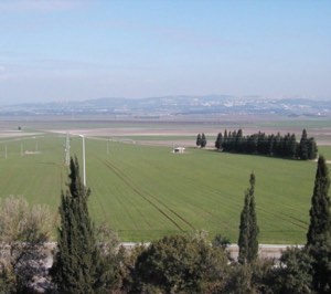
According to the field description published by Walid Khalidi in All That Remains, piles of stone rubble from the village houses were scattered across the site, which had become overgrown with cactus, thorny vegetation, and shrubs. The shrine of Shaykh Abd Allah was still standing.
This description derives from fieldwork conducted before the publication of All That Remains in 1992 and should not be treated as direct field verification of the site's condition in 2026.
Palestine Remembered contains later community documentation of the shrine, cemetery, village spring, and remains of demolished houses, including material associated with visits in 2008, 2010, and later years. This documentation indicates that some physical traces remained visible after Khalidi's survey, but it does not constitute an independent and comprehensive present-day field survey, and upload dates should not automatically be treated as the dates on which all materials were recorded.
Sources
- PalQuestPalQuest – Interactive Encyclopedia of the Palestine Question: Umm al-Shawf
- PalQuestPalQuest – Israeli Intelligence Report on the Depopulation of Palestine, 30 June 1948
- Palestine RememberedPalestine Remembered – Umm al-Shawf, Haifa
- Palestine RememberedPalestine Remembered – Umm al-Shawf entry from All That Remains
- Institute for Palestine StudiesInstitute for Palestine Studies – Walid Khalidi, All That Remains
- pcbs.gov.psGovernment of Palestine – Census of Palestine 1922
- content.ecf.org.ilGovernment of Palestine – Census of Palestine 1931: Population of Villages, Towns and Administrative Areas
- commons.wikimedia.orgGovernment of Palestine – Village Statistics, April 1945
- palqura.comSalman Abu Sitta – Atlas of Palestine 1917–1966
Photo gallery


Photos from the village's people
Photos sent in by visitors and published after review.
Add a photo of this village
Log in to add photos of this village.
Other villages from Haifa
More from the archive



 Download Our Palestine App
The whole archive in the palm of your hand: depopulated villages, the Nakba, the massacres and Al-Aqsa — free, with no ads to erase the story.
Download Our Palestine App
The whole archive in the palm of your hand: depopulated villages, the Nakba, the massacres and Al-Aqsa — free, with no ads to erase the story.



Comments
No comments yet — be the first to write one.
Add your comment
Name and email are optional. Comments appear after review.