
The depopulated village of Al-Butaymat / District of Haifa
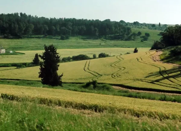
Al-Butaymat
About the depopulated village of Al-Butaymat
- District
- Haifa
- Date Al-Butaymat was occupied
- 14 April 1948
- Population in 1948
- 130
- Military operation
- The Battle of Mishmar ha-'Emeq
- Brigade that carried it out
- Irgun
- Distance from the governorate centre
- 31 (km) South East of Haifa
- Elevation above sea level
- 200 m
- Cause of displacement
- Fear of Jewish attack, or of being caught in the fighting
- Extent of destruction
- The village has been completely obliterated, and only house rubble left behind.
- Ethnic cleansing
- al-Butaymat inhabitants mostly fled soon after the battle for Mishmar Ha'emek, and upon occupation it was completely ethnically cleansed.
Hover a dot to read the village name, or click to open its card.
Borders of the depopulated village of Al-Butaymat
Al-Butaymat – Depopulated Palestinian Village of the Haifa Subdistrict
Al-Butaymat was a depopulated Palestinian village in the Haifa Subdistrict, located approximately 31 kilometers southeast of Haifa. It stood at an average elevation of about 200 meters above sea level in the hilly region of Bilad al-Rawha'.
The village was built on the slope of a small wadi. Its narrow built-up area extended generally from east to west and became progressively narrower toward the west. Several springs around the site provided water, while agriculture and livestock raising formed the main basis of the village economy.
- District
- Haifa
- Distance from Haifa
- Approximately 31 km southeast of Haifa
- Elevation
- Approximately 200 m above sea level
- Natural Setting
- On the slope of a small wadi in the hilly region of Bilad al-Rawha'
- Population in 1944/1945
- 110 inhabitants
- Estimated Population in 1948
- 128 inhabitants – a later estimate published by Palestine Remembered, not an official census
- Occupation and Depopulation Period
- 14 April 1948 is the stronger documented date for occupation; Palestine Remembered displays 1 May in its summary field
- Military Context
- The Haganah counteroffensive following the Battle of Mishmar HaEmek
- Military Unit
- Not conclusively identified at village level; the wider battle involved Palmach units and forces of the Carmeli and Alexandroni brigades
- Total Land Area
- 8,557 dunums
- Settlements on Village Lands
- Even Yitzhaq / Gal'ed, established in 1945; Regavim was temporarily established near al-Butaymat in July 1948 before moving to Qannir in 1949
The Name Al-Butaymat and Bilad al-Rawha'
The name al-Butaymat is associated with the butm or terebinth tree, a species familiar in Palestine and the Levant. The village stood in the heart of the wider hilly region known as Bilad al-Rawha'.
The Palestine Index Gazetteer published during the British Mandate classified al-Butaymat as a hamlet, reflecting the relatively small size of its built-up settlement.
Location and Built Environment
Al-Butaymat stood on the slope of a small wadi in a generally hilly landscape. Its built-up area formed a narrow strip extending from east to west and narrowing toward the west.
The houses were constructed of stone joined with either mud or cement mortar. Despite the village's small size, its Muslim inhabitants maintained their own mosque.
Population of Al-Butaymat
The inhabitants of al-Butaymat were Muslims. The official censuses show a modest decline in population between 1922 and 1931, followed by a population of approximately 110 in the mid-1940s.
- 1922137Official Census of Palestine, 1922; all were Muslims
- 1931112Official Census of Palestine, 1931
- 1944/1945110Official British Mandate statistics
- 1948128Later estimate published by Palestine Remembered; not an official census
- 1998784 refugeesLater estimate of refugees and descendants; not an official census
Number of Houses
- 193129 occupied housesOfficial census
- 194833 housesLater estimate published by Palestine Remembered; not an official 1948 census figure
Land Ownership in Al-Butaymat
The total land area of al-Butaymat amounted to 8,557 dunums in the 1944/45 statistics. Palestine Remembered presents the simplified ownership categories as follows:
- Palestinian3,832 dunums45%
- Transferred to Zionists4,724 dunums55%
- Communal/Public1 dunums<1%
The official 1944/45 Village Statistics use the categories Arab, Jewish, and Public, listing 3,832 Arab dunums, 4,724 Jewish dunums, and one public dunum, for the same total of 8,557 dunums.
Land Use in 1944/1945
- Arab
- Jewish
- Public
- Cereals7,230 dunums
- Plantations and Irrigable Land9 dunums
- Built-up Area5 dunums
- Non-Cultivable Land1,313 dunums
Cultivated or cultivable land therefore amounted to 7,239 dunums, approximately 85 percent of the total village area, while built-up and non-cultivable land together amounted to 1,318 dunums.
Palestine Remembered separately displays a figure of 113 dunums planted with olives. This figure is not added to the official 1944/45 land-use table because that table already accounts for the entire 8,557 dunums without a separate olive category; adding it would therefore risk double counting.
Economic Life in Al-Butaymat
The villagers depended primarily on agriculture and livestock raising. Cereals constituted the main crop by area: 2,508 dunums of Arab-classified land were allocated to cereals in 1944/45.
A further 8 dunums of Arab-classified land were irrigated or used for orchards. Livestock breeding was another important component of the local rural economy.
Water Resources
Several springs surrounded the village site and supplied the inhabitants with water for domestic and agricultural purposes. These springs were among the most important natural features of the village's location in Bilad al-Rawha'.
Education in Al-Butaymat
The principal sources reviewed for this article do not provide sufficiently documented information about an independent school in al-Butaymat, its establishment date, or enrollment. No unsupported school date or student figure is therefore supplied.
The Mosque and Religious Life
The residents of al-Butaymat were Muslims, and despite the small size of the village they maintained their own mosque.
Occupation and Depopulation of Al-Butaymat
The occupation of al-Butaymat was associated with the Battle of Mishmar HaEmek and the Haganah counteroffensive against surrounding Palestinian villages in April 1948.
The battle began on 4 April when the Arab Liberation Army attacked Mishmar HaEmek. After the offensive stalled, Haganah commanders rejected a proposed truce and decided instead to extend their counterattack into the surrounding Palestinian villages.
On the night of 8–9 April, Haganah forces began capturing villages around Mishmar HaEmek. Historical material reproduced by Walid Khalidi identifies forces involved during the wider fighting as including the First Battalion of the Palmach and units from the Carmeli and Alexandroni brigades. By 14 April, approximately ten villages had fallen to Haganah forces.
PalQuest's entry on neighboring al-Rihaniyya, citing a contemporary press report, states that al-Rihaniyya, Daliyat al-Rawha', and al-Butaymat were occupied together on 14 April 1948. This provides the strongest documented date for the occupation of the al-Butaymat site.
Palestine Remembered separately displays 1 May 1948 in its summary field and describes the cause of departure as fear of attack or fear of becoming caught up in the fighting. Its detailed historical text does not independently establish 1 May as the actual date of occupation.
Occupation Chronology
- 4 April 1948
Beginning of the Battle of Mishmar HaEmek
The Arab Liberation Army attacked Mishmar HaEmek, beginning the battle that was followed by a broad Haganah counteroffensive.
- 8–9 April 1948
Beginning of the Counteroffensive
Haganah forces began capturing surrounding Palestinian villages. The wider battle involved Palmach units and forces from the Carmeli and Alexandroni brigades.
- 14 April 1948
Occupation of Al-Butaymat
A contemporary account reproduced through PalQuest states that al-Butaymat was occupied on this date together with Daliyat al-Rawha' and al-Rihaniyya.
- 1 May 1948
Conflicting Database Date
Palestine Remembered displays this date in its summary field, but its historical narrative does not independently document it as the precise occupation date.
- After occupation; precise date undocumented
Destruction
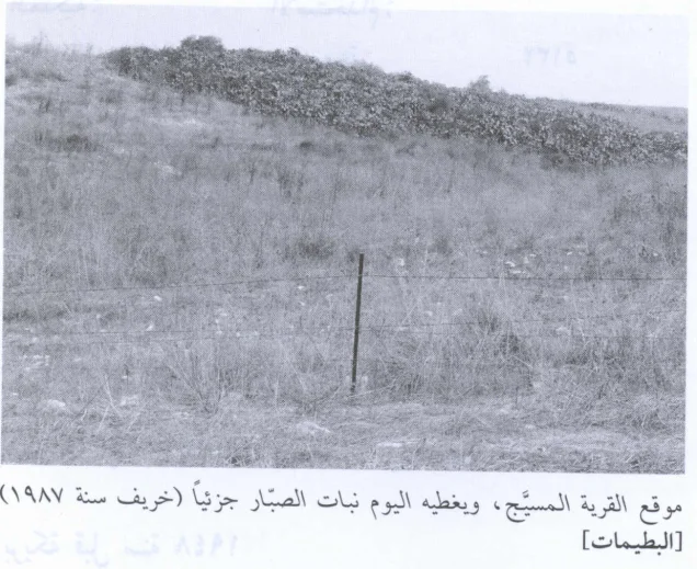
The village's built-up area was subsequently destroyed, with later field documentation recording only scattered adobe bricks at the site.
Battle of Mishmar HaEmek and Military Unit
Military Context: The Haganah counteroffensive following the Battle of Mishmar HaEmek in April 1948.
Military Unit: The principal sources do not identify the exact force that entered al-Butaymat at the village level. Units participating in the wider fighting around Mishmar HaEmek included the First Battalion of the Palmach and forces from the Carmeli and Alexandroni brigades.
Palestine Remembered lists the Irgun as the “most likely” attacking force in a summary field. This attribution is not independently supported by a village-specific historical account, however, and is therefore not presented here as a confirmed identification.
Cause of Depopulation
The principal historical sources do not provide a detailed independent account of the exact moment in which all residents left al-Butaymat. Palestine Remembered classifies the cause as fear of attack or fear of being caught in the fighting.
The historical chronology places the village's depopulation within the collapse of Palestinian villages around Mishmar HaEmek during the April 1948 military offensive. The cause is therefore presented with appropriate caution rather than converted into a more specific claim unsupported by the sources.
Destruction of Al-Butaymat
The principal sources do not establish a precise date for the destruction of al-Butaymat following its occupation. Later field documentation nevertheless indicates that the village's houses had virtually disappeared, leaving only scattered adobe bricks.
Settlements on Al-Butaymat Village Lands
Even Yitzhaq, also known as Gal'ed, was established in 1945 on al-Butaymat village lands west of the village site. It was therefore founded before the Nakba on part of the village's territory.
In July 1948, Regavim was initially established near al-Butaymat. This location was temporary: the settlement was transferred in 1949 to the lands of the depopulated village of Qannir. Regavim should therefore be described as a temporary post-occupation settlement associated with the al-Butaymat site rather than as a permanent settlement remaining on its lands.
Al-Butaymat Today
According to the field documentation used by Walid Khalidi, the village site was fenced and covered with grass and cactus. No identifiable houses remained, apart from scattered adobe bricks across the site.
Most of the surrounding land was being used as pasture, while some sections remained under cultivation.
PalQuest publishes a photograph of the site dated September 1987. This description therefore reflects historical field documentation from the period preceding the publication of All That Remains in 1992 and should not be treated as a direct field verification of conditions in 2026.
Sources
- PalQuest – Interactive Encyclopedia of the Palestine Question: al-Butaymat
- PalQuest – al-Rihaniyya: account of the occupation of al-Rihaniyya, Daliyat al-Rawha' and al-Butaymat on 14 April 1948
- PalQuest – Abu Shusha: background to the Battle of Mishmar HaEmek and participating forces
- Palestine Remembered – al-Butaymat, Haifa District
- Palestine Remembered – Historical account of al-Butaymat from Walid Khalidi's All That Remains
- Government of Palestine – Census of Palestine, 1922
- Government of Palestine – Census of Palestine, 1931
- Village Statistics 1945 – Government of Palestine statistics, reproduced by Sami Hadawi
- PalQuest – Qannir: transfer of Regavim from the al-Butaymat area to Qannir in 1949
- Institute for Palestine Studies – Walid Khalidi, material on settlements associated with Plan Dalet and its aftermath
Photo gallery

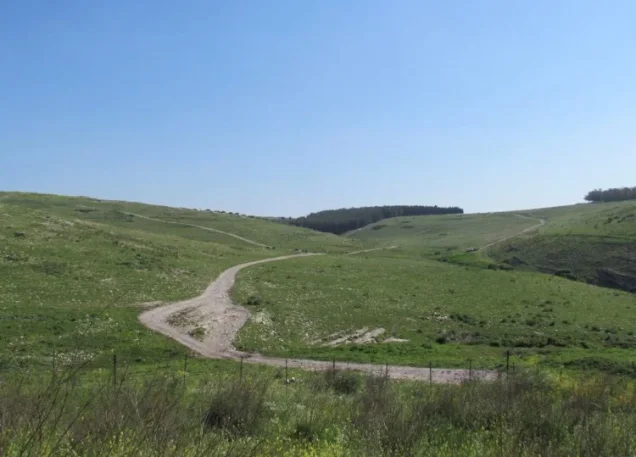

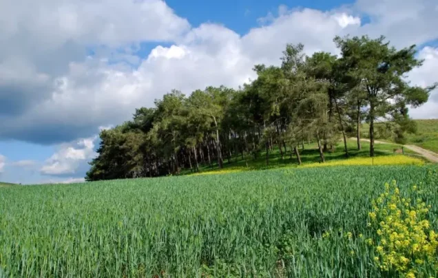
Photos from the village's people
Photos sent in by visitors and published after review.
Add a photo of this village
Log in to add photos of this village.
Other villages from Haifa

More from the archive


 Download Our Palestine App
The whole archive in the palm of your hand: depopulated villages, the Nakba, the massacres and Al-Aqsa — free, with no ads to erase the story.
Download Our Palestine App
The whole archive in the palm of your hand: depopulated villages, the Nakba, the massacres and Al-Aqsa — free, with no ads to erase the story.



Comments
No comments yet — be the first to write one.
Add your comment
Name and email are optional. Comments appear after review.