
The depopulated village of Al-Mansi ('Arab Baniha) / District of Haifa
Al-Mansi ('Arab Baniha)
About the depopulated village of Al-Mansi ('Arab Baniha)
- District
- Haifa
- Date Al-Mansi ('Arab Baniha) was occupied
- 13 April 1948
- Population in 1948
- 1,392
- Military operation
- The Battle of Mishmar ha-'Emeq
- Distance from the governorate centre
- 30 (km) South East of Haifa
- Elevation above sea level
- 125 m
- Cause of displacement
- Military assault by Zionist troops
- Extent of destruction
- Soon after occupation, the village has been mostly destroyed with the exception of the its school and its mosque.
- Ethnic cleansing
- al-Mansi inhabitants were completely ethnically cleansed.
Hover a dot to read the village name, or click to open its card.
Borders of the depopulated village of Al-Mansi ('Arab Baniha)
Al-Mansi ('Arab Baniha) – Depopulated Palestinian Village of the Haifa Subdistrict
Al-Mansi, also known as 'Arab Baniha, was a depopulated Palestinian village in the Haifa Subdistrict. It stood at the western edge of the Marj ibn 'Amir plain, south of the main Haifa–Jenin highway, approximately 30 kilometers from Haifa and at an average elevation of about 125 meters above sea level.
The village overlooked the broad agricultural plain of Marj ibn 'Amir and benefited from abundant water resources and fertile surrounding land. Its economy depended primarily on agriculture—especially cereals, olives, and vegetables—and animal husbandry. Al-Mansi had a mosque, a boys' elementary school, a grain mill, and at least six springs.
- District
- Haifa
- Distance from Haifa
- Approximately 30 km
- Elevation
- Approximately 125 m above sea level
- Natural Setting
- At the western edge of Marj ibn 'Amir, south of the Haifa–Jenin highway and overlooking the plain
- Population in 1944/1945
- 1,200 inhabitants: 1,180 Muslims and 20 Christians
- Estimated Population in 1948
- 1,392 inhabitants – a later estimate published by Palestine Remembered, not an official census
- Occupation and Depopulation Period
- Infiltration and fighting on 9 April 1948; principal occupation during the night of 12–13 April; a further reported Israeli entry occurred in late May
- Military Context
- The Haganah counteroffensive during the Battle of Mishmar HaEmek; no separate named operation specific to al-Mansi is given
- Military Unit
- Palmach units; the principal village source does not identify a specific battalion
- Total Land Area
- 12,272 dunums
- Settlement Established on Village Lands
- Midrakh Oz, established in 1952 near the village site; part of it lies on al-Mansi land
Al-Mansi and 'Arab Baniha
The village appears in the historical sources as al-Mansi and was also known as 'Arab Baniha. PalQuest additionally lists 'Ayn al-Mansi among names associated with it, but the same source documents a separate village called 'Ayn al-Mansi less than half a kilometer southeast of al-Mansi.
The two localities should therefore not be confused. Al-Mansi / 'Arab Baniha belonged to the Haifa Subdistrict, whereas 'Ayn al-Mansi was a separate locality in the Jenin Subdistrict with its own population, land area, and statistical record.
Location and Built Environment
Al-Mansi stood at the western edge of the Marj ibn 'Amir plain on the southern side of the main Haifa–Jenin highway, overlooking the agricultural valley.
Village houses were built of stone joined with cement or mud mortar. Some roofs incorporated timber, straw, and mud. The built-up pattern varied: houses in one section were spaced apart, while in another they stood closely side by side.
The official 1944/45 land-use statistics recorded approximately 17 dunums as built-up land.
Population of Al-Mansi
The village experienced substantial population growth during the British Mandate. The 1931 figure requires an important qualification: PalQuest states that it includes 'Arab Bani Su'aydan, 'Arab Dabaya, and Bani Gharra in addition to the population grouped under al-Mansi.
- 192272Official Census of Palestine: 68 Muslims and 4 Christians
- 1931467Official census: 461 Muslims and 6 Christians; includes associated 'Arab Baniha communities
- 1944/19451,200Official statistics: 1,180 Muslims and 20 Christians
- 19481,392Later estimate published by Palestine Remembered; not an official census
- 19988,548 refugeesLater estimate of refugees and descendants; not an official village census
Number of Houses
- 193198 occupied housesOfficial census figure associated with the al-Mansi / 'Arab Baniha statistical population
- 1948292 housesLater estimate published by Palestine Remembered; not an official 1948 census figure
Land Ownership in Al-Mansi
Al-Mansi had a total land area of 12,272 dunums in the 1944/45 statistics. The official table recorded no land under Jewish ownership.
Palestine Remembered presents the simplified ownership categories as follows:
- Palestinian7,611 dunums62%
- Transferred to Zionists0 dunums0%
- Communal/Public4,661 dunums38%
The official Village Statistics instead use the categories Arab and Public: 7,611 Arab dunums and 4,661 public dunums, totaling 12,272 dunums.
Land Use in 1944/1945
- Arab
- Public
- Cereals6,559 dunums
- Plantations and Irrigable Land1,391 dunums
- Built-up Area17 dunums
- Non-Cultivable Land4,305 dunums
Cultivated or cultivable land totaled 7,950 dunums, approximately 65 percent of the village land area. Built-up and non-cultivable land together amounted to 4,322 dunums, or about 35 percent.
Within the 1,391 dunums of plantations and irrigable land, approximately 243 dunums were planted with olives. The olive figure is therefore a subset of the plantation category and should not be added again to the total land-use calculation.
The simplified Palestine Remembered table requires separation according to the official statistics: the 6,559 dunums of cereal land consist of 5,904 Arab and 655 public dunums, while the 4,305 non-cultivable dunums consist of 299 Arab and 4,006 public dunums.
Economic Life in Al-Mansi
Al-Mansi's economy depended primarily on agriculture and animal husbandry. Cereals occupied the largest cultivated area, while olives and vegetables were also important.
In 1944/45, 5,904 dunums of Arab-classified land were devoted to cereals, while 1,391 dunums consisted of irrigated land or orchards, including 243 dunums planted with olive trees.
The village also had a grain mill, reflecting the importance of cereal production, while livestock raising provided another major component of household income.
Water Resources
Al-Mansi was notable for its water resources and had at least six springs in its vicinity. Palestinian local sources identify 'Ayn al-Khalla as an important source used for drinking and household purposes.
Other locally recorded water sources include Bir al-Bayda, Bir al-Madina, 'Ayn al-Basha, 'Ayn al-Samtat, and 'Ayn al-Mashkha.
Education
Al-Mansi had an elementary school for boys. Community archival material also documents the school's activity during the 1940s, including a 1946 document associated with one of its teachers.
The principal sources used for this article do not provide one consistently documented enrollment figure or definitive establishment year, so no unsupported number is supplied.
The Mosque and Grain Mill
The village had a mosque serving its Muslim population as well as a grain mill. The mosque building and remains of the school were still standing in the later field documentation used by Walid Khalidi.
Occupation and Depopulation of Al-Mansi
The occupation of al-Mansi took place during the fighting that followed the Arab Liberation Army's attack on Mishmar HaEmek in early April 1948 and the subsequent Haganah counteroffensive against surrounding Palestinian villages.
According to the Palestinian newspaper Filastin, as cited by Khalidi, Zionist forces infiltrated al-Mansi on 9 April 1948 and exchanged fire with the village's defenders.
On 11 April, Arab Liberation Army commander Fawzi al-Qawuqji reported that his forces withdrew to al-Mansi after a severe counterattack.
During the night of 12–13 April 1948, Palmach units moved against al-Mansi and occupied it together with neighboring al-Naghnaghiyya.
After Haganah commanders rejected a proposed ceasefire, the counteroffensive widened to include the occupation and destruction of surrounding villages. Khalidi, citing Benny Morris, states that all of al-Mansi's houses were blown up in the following days and that the inhabitants were probably displaced at the same time.
A contemporary New York Times report at the end of May, however, described Israeli columns advancing into the Triangle from the northwest and occupying al-Mansi and other villages. Khalidi notes that this may indicate that the Haganah did not maintain a continuous presence in al-Mansi after the April occupation.
Occupation Chronology
- 4 April 1948
Beginning of the Battle of Mishmar HaEmek
The fighting around Mishmar HaEmek began and was followed by a Haganah counteroffensive against surrounding Palestinian villages.
- 9 April 1948
Infiltration and Fighting at Al-Mansi
Filastin reported that Zionist forces infiltrated the village and exchanged fire with its defenders.
- 11 April 1948
Arab Liberation Army Withdrawal to Al-Mansi
Fawzi al-Qawuqji reported that his forces withdrew to the village following a severe counterattack.
- Night of 12–13 April 1948
Principal Occupation
Palmach units moved against al-Mansi and occupied it together with al-Naghnaghiyya.
- Following days
Depopulation and Destruction of Houses
Khalidi's account states that all village houses were blown up and that the inhabitants were probably displaced during the same phase.
- Late May 1948
Reported Renewed Occupation
A contemporary press report described another Israeli advance into al-Mansi, possibly indicating that control had not remained continuous since April.
Military Context and Unit
Military Context: The Haganah counteroffensive during the Battle of Mishmar HaEmek in April 1948. The village entry does not identify a separately named military operation specific to al-Mansi.
Military Unit: Palmach units. The principal source identifies the Palmach at the village level but does not specify a particular battalion, so no battalion number is added solely from the wider battle context.
Cause of Depopulation
The displacement of al-Mansi's population was directly associated with the military attack, occupation of the village on the night of 12–13 April 1948, and the subsequent demolition of its houses.
Palestine Remembered classifies the cause of departure as a direct military assault. Khalidi likewise links the villagers' displacement to the occupation and destruction of the village, while remaining cautious about the exact moment at which all residents left.
Destruction of Al-Mansi
Khalidi, citing Benny Morris, states that all of al-Mansi's houses were blown up in the days following its occupation in April 1948.
This did not mean that every structure disappeared. The village school and mosque, together with foundations and fragments of other buildings, survived and were documented in later field surveys.
Israeli Settlement on Al-Mansi Village Lands
Midrakh Oz was established in 1952 close to the former village site, and part of the settlement lies on al-Mansi village land.
PalQuest notes that Midrakh Oz occupies part of the adjacent land, while other areas were subsequently used for avocado cultivation and for raising poultry and cattle.
Al-Mansi Today
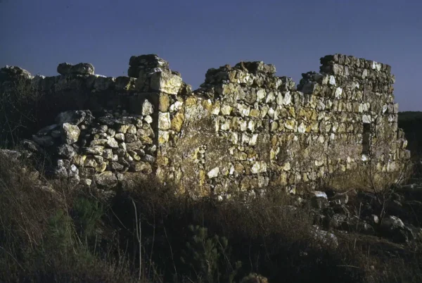
According to Walid Khalidi's historical field documentation, the remains of the village school and mosque were still standing amid dense vines and thorny bushes.
Exposed foundations of destroyed buildings, surrounded by stone rubble, remained visible throughout the site, together with numerous cactus plants and trees.
Midrakh Oz occupied part of the surrounding land, while other areas were being used for avocado cultivation and for raising poultry and cattle.
PalQuest publishes a photograph of a surviving village wall dated May 1987. This description therefore reflects historical field documentation predating the publication of All That Remains in 1992 and should not be treated as a direct field verification of conditions in 2026.
Palestine Remembered also published community videos during 2026 documenting visits to the village site and discussing surviving features such as the school and well. These can be treated as later community documentation rather than as a comprehensive independent archaeological survey.
Sources
- PalQuest – Interactive Encyclopedia of the Palestine Question: al-Mansi
- PalQuest – 'Ayn al-Mansi: distinguishing the Jenin village from al-Mansi / 'Arab Baniha in Haifa
- Palestine Remembered – al-Mansi ('Arab Baniha), Haifa District
- Palestine Remembered – Historical account of al-Mansi from Walid Khalidi's All That Remains
- Government of Palestine – Census of Palestine, 1922
- Government of Palestine – Census of Palestine, 1931, E. Mills
- Sami Hadawi – Village Statistics 1945, reproducing Government of Palestine statistics
- WAFA – Depopulated Villages of the Haifa District: al-Mansi
- Institute for Palestine Studies – Walid Khalidi, All That Remains
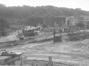
Photos from the village's people
Photos sent in by visitors and published after review.
Add a photo of this village
Log in to add photos of this village.
Other villages from Haifa

More from the archive


 Download Our Palestine App
The whole archive in the palm of your hand: depopulated villages, the Nakba, the massacres and Al-Aqsa — free, with no ads to erase the story.
Download Our Palestine App
The whole archive in the palm of your hand: depopulated villages, the Nakba, the massacres and Al-Aqsa — free, with no ads to erase the story.



Comments
No comments yet — be the first to write one.
Add your comment
Name and email are optional. Comments appear after review.