
The depopulated village of Al-Ghubayya al-Tahta / District of Haifa
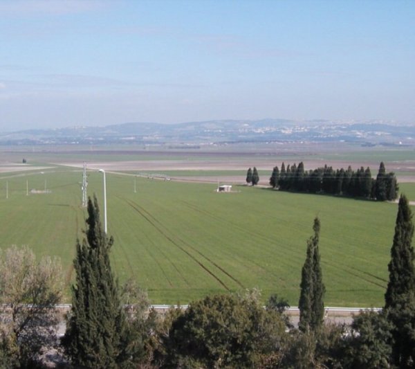
Al-Ghubayya al-Tahta
About the depopulated village of Al-Ghubayya al-Tahta
- District
- Haifa
- Date Al-Ghubayya al-Tahta was occupied
- 12 March 1948
- Population in 1948
- 1,130
- Military operation
- The Battle of Mishmar ha-'Emeq
- Brigade that carried it out
- Palmach
- Who defended the village
- Arab Liberation Army
- Distance from the governorate centre
- 28 (km) South East of Haifa
- Elevation above sea level
- 110 m
- Cause of displacement
- Military assault by Zionist troops
- Extent of destruction
- The village has been completely obliterated in mid March 1948
- Ethnic cleansing
- al-Ghubayya al-Tahta inhabitants were completely ethnically cleansed.
- Settlements built on the built-up area of Al-Ghubayya al-Tahta after 1948
- Part of Mishmar HaEmek
Hover a dot to read the village name, or click to open its card.
al-Ghubayya al-Tahta – Depopulated Palestinian Village of Haifa
Al-Ghubayya al-Tahta was a Palestinian village in the Haifa Subdistrict and one of three neighboring villages collectively known as al-Ghubayyat: al-Ghubayya al-Tahta, al-Ghubayya al-Fawqa, and al-Naghnaghiyya. The three villages stood on the eastern slopes of Bilad al-Rawha, near the western edge of Marj Ibn 'Amir and close to the main Haifa-Jenin road.
Al-Ghubayya al-Tahta stood on a hill overlooking Marj Ibn 'Amir, approximately 28 kilometers southeast of Haifa, at an average elevation of about 110 meters above sea level. It was also known as al-Ghaba al-Tahta, while the qualifier “al-Tahta,” or “Lower,” distinguished it from its sister village al-Ghubayya al-Fawqa.
The village experienced several distinct phases of attack, displacement, occupation, and destruction during spring 1948. Residents first left following an attack in March. The two Ghubayya villages then became a battlefield during the fighting around Mishmar ha-'Emeq in April, changed hands several times, and were eventually captured. A subsequent attack on 25 April destroyed houses that had survived the earlier demolition.
Basic Information
| Field | Information |
|---|---|
| Name | al-Ghubayya al-Tahta |
| Arabic name | الغُبَيَّة التحتا |
| Alternative name | al-Ghaba al-Tahta |
| Subdistrict | Haifa |
| Region | Bilad al-Rawha – western edge of Marj Ibn 'Amir |
| Distance from Haifa | Approximately 28 km southeast according to Khalidi and PalQuest |
| Elevation | Approximately 110 m above sea level |
| Palestine Grid | 163/223 |
| Population in 1922 | 80 in the official census |
| Population in 1931 | 200 for al-Ghubayya al-Tahta and al-Ghubayya al-Fawqa combined; no separate official figure for al-Tahta |
| Population in 1945 | 1,130 for all three al-Ghubayyat villages combined; no separate official figure for al-Tahta |
| Official land area | 12,139 dunums for the three al-Ghubayyat collectively; no separate 1945 village total is provided for al-Tahta |
| First attack and initial evacuation | 12 March 1948 |
| First military entry during the Mishmar ha-'Emeq fighting | 8–9 April 1948 |
| Final military capture | Approximately mid-April 1948; Khalidi does not establish an exact final day |
| Last documented major demolition phase | 25 April 1948 – destruction of houses that remained standing |
| Military context | Battle of Mishmar ha-'Emeq and the Haganah counteroffensive against surrounding villages |
| Forces involved in occupying the two Ghubayya villages | Units drawn from the Palmach, Carmeli Brigade, and Alexandroni Brigade; no specific battalion is independently established for al-Ghubayya al-Tahta alone |
| Israeli settlement | Part of Midrakh Oz lies on village land according to Khalidi and PalQuest |
The al-Ghubayyat and the Village Name
Al-Ghubayya al-Tahta belonged to the three-village group known collectively as al-Ghubayyat, together with al-Ghubayya al-Fawqa and al-Naghnaghiyya. Khalidi explains the collective name as meaning the “little forests.” The wider area was known as Bilad al-Rawha, traditionally interpreted as the “fragrant country.”
The qualifier al-Tahta, meaning “Lower,” distinguished the village from neighboring al-Ghubayya al-Fawqa, or the “Upper” Ghubayya.
Location and Boundaries
The village houses extended along a hill overlooking Marj Ibn 'Amir. The main Haifa-Jenin road passed nearby to the northeast, placing the village close to an important transportation corridor connecting the coast, the Jezreel Valley, and Jenin.
Palestinian local documentation places al-Ghubayya al-Fawqa and Ji'ara to the south, Abu Shusha and Abu Zurayq to the north, al-Naghnaghiyya to the east, and the lands of Daliyat al-Rawha, al-Rayhaniyya, and Umm al-Dufuf toward the west.
Built Environment
The Palestine Index Gazetteer classified al-Ghubayya al-Tahta as a farm, as it did its sister village al-Ghubayya al-Fawqa. The village had an elongated built-up form, and houses were constructed using combinations of stone, mud, and cement.
Palestinian local documentation adds that some houses were roofed with timber and mud and that structures made from goat hair were also used by some families.
Population
The population figures must be separated carefully between independent counts for al-Ghubayya al-Tahta and figures that combined it statistically with the neighboring Ghubayya villages.
| Year | Population | Status of Figure |
|---|---|---|
| 1922 | 80 | Independent official census figure: 79 Muslims and one person recorded in the Christian category |
| 1931 | 200 | Official combined figure for al-Ghubayya al-Tahta and al-Ghubayya al-Fawqa, not for al-Tahta alone |
| 1945 | 1,130 | Official combined figure for al-Ghubayya al-Tahta, al-Ghubayya al-Fawqa, and al-Naghnaghiyya |
| 1948 | No independently documented figure | The combined 1945 total of 1,130 should not be relabeled as an independent 1948 population for al-Ghubayya al-Tahta |
The figure of 1,130 sometimes presented online as the population of al-Ghubayya al-Tahta at the time of the Nakba is therefore the 1945 official total for all three al-Ghubayyat villages.
Number of Houses
The 1931 census recorded 38 houses for al-Ghubayya al-Tahta and al-Ghubayya al-Fawqa combined. The figure of 38 should not be presented as an independent house count for al-Ghubayya al-Tahta.
A Palestinian local-history source assigns approximately 30 dwellings to al-Ghubayya al-Tahta in 1931. This is useful community documentation, but it is distinct from the official census figure, which combined the two villages.
Land Ownership, 1944/45
The official land statistics did not separate al-Ghubayya al-Tahta, al-Ghubayya al-Fawqa, and al-Naghnaghiyya. The following figures therefore apply collectively to all three al-Ghubayyat villages:
- Palestinian11,607 dunums96%
- Transferred to Zionists0 dunums0%
- Public / Communal532 dunums4%
The figures balance exactly: 11,607 + 532 = 12,139 dunums.
Some online tables reproduce the individual rows correctly but mistakenly give 532 as the overall total. The correct total, confirmed by the official statistical unit, is 12,139 dunums.
Land Use, 1944/45
- Cereals10,883 dunums90%
- Plantations and irrigable land209 dunums2%
- Non-cultivable land1,047 dunums9%
The land-use figures balance exactly: 10,883 + 209 + 1,047 = 12,139 dunums. These figures apply to the combined al-Ghubayyat statistical unit and should not be mathematically divided among the three villages without a separate documentary basis.
Economy and Agriculture
The inhabitants of the al-Ghubayyat depended primarily on farming and animal husbandry. Cereals were the principal crops, reflected in the 10,883 dunums classified as cereal land for the combined statistical unit in 1944/45.
The villages also benefited from the relatively abundant water resources of Bilad al-Rawha, including wadis, springs, and the al-Muqatta' River, which supported livestock raising and limited irrigated agriculture and orchards.
Water Resources
Khalidi records that the three villages were connected with several wadis, springs, and the al-Muqatta' River. Palestinian community documentation provides additional local names, including Wadi al-Turayma, Wadi Fakhakhira, 'Ayn al-Darwishiyya, 'Ayn al-Jawarir, 'Ayn al-Zaytuna, and Wadi 'Ayn al-Hajj Amin.
Some were used for drinking and others primarily for watering livestock. These detailed names are retained as Palestinian local documentation.
Education
Al-Ghubayya al-Tahta shared an elementary school with al-Ghubayya al-Fawqa and al-Naghnaghiyya. The school was established in 1888 during Ottoman rule.
It was subsequently closed during the British Mandate. The principal sources consulted do not provide a reliable official figure for enrollment or teachers, so no unsupported figures are supplied.
Mosque and Cemetery
Khalidi's concise village description does not provide details of an individual mosque at al-Ghubayya al-Tahta. Palestinian local-history documentation, however, records both a mosque and a cemetery.
According to this community documentation, the mosque stood toward the eastern side of the village, slightly to the south, and was built of stone with a concrete roof and a mihrab. These architectural details are retained as attributed local documentation rather than presented as information from an independent official record.
Archaeological Remains
Several khirbas in the lands of the al-Ghubayyat contained archaeological remains including pottery fragments, masonry, and an olive press. Tall Abu Shusha was the nearest major archaeological site to al-Ghubayya al-Tahta.
No specific archaeological period is assigned to these remains here unless explicitly established by the source.
The First Attack – March 1948
Al-Ghubayya al-Tahta was attacked several weeks before the Battle of Mishmar ha-'Emeq. Khalidi cites a press report written in mid-March stating that the village had been evacuated following an attack on Friday, 12 March 1948.
The report stated that the Haganah destroyed fourteen houses and damaged ten more. No deaths were reported in that attack because the residents had already evacuated the village.
Palestinian historian Arif al-Arif also documented the attack but described the scale of destruction more broadly, stating that the village was destroyed in the early months of the war by Zionist forces operating from the direction of nearby Mishmar ha-'Emeq. He added that the inhabitants escaped harm because they had sought refuge in al-Ghubayya al-Fawqa.
Because the sources differ over the scale of destruction at this stage, the most cautious conclusion is that the March attack caused extensive documented damage. It did not, however, destroy every structure, since houses still standing were demolished later on 25 April.
The Battle of Mishmar ha-'Emeq
In early April 1948, the Arab Liberation Army under Fawzi al-Qawuqji attacked Mishmar ha-'Emeq. British authorities subsequently intervened in an effort to halt the fighting.
According to the account reproduced by Khalidi, the Arab Liberation Army agreed to cease its attack if the neighboring Arab villages were protected from retaliation. The Haganah command did not accept this condition and instead ordered forces to move against villages surrounding the Marj Ibn 'Amir area.
Occupation of al-Ghubayya al-Tahta
The occupation of al-Ghubayya al-Tahta cannot accurately be reduced to the date 8 April alone.
Khalidi's account for al-Ghubayya al-Fawqa, which explicitly discusses both sister villages, states that Haganah units drawn from the Palmach, Carmeli Brigade, and Alexandroni Brigade first entered al-Ghubayya al-Tahta and al-Ghubayya al-Fawqa during the night of 8–9 April 1948 amid intense fighting.
This first occupation was not permanent. Fighting intensified the following day and the Arab Liberation Army drove the attacking forces out. Haganah control remained precarious over the next several days, with forces entering and withdrawing as the villages changed hands.
According to the sequence attributed to al-Qawuqji and reproduced by Khalidi, the two villages changed hands several times before finally falling to Zionist forces around the middle of April.
The most accurate distinction is therefore:
8–9 April 1948: first military entry and temporary occupation during the Mishmar ha-'Emeq fighting.
Approximately mid-April 1948: final military capture following repeated changes of control.
Military Units
Khalidi records that the forces entering the two Ghubayya villages included units drawn from the Palmach, the Carmeli Brigade, and the Alexandroni Brigade.
The source does not identify a specific battalion as the independently documented unit that entered al-Ghubayya al-Tahta itself. No battalion number is therefore assigned without supporting evidence.
Cause of Depopulation
Palestine Remembered classifies the cause of depopulation as a direct military assault.
Khalidi's narrative supports the basic military context: residents evacuated following the March attack and initially sought refuge in neighboring al-Ghubayya al-Fawqa, while the entire area became a repeated battlefield in April.
The available account does not conclusively establish whether every inhabitant remained away continuously from 12 March onward or whether some returned between stages of fighting. The 12 March evacuation should therefore not automatically be treated as one precisely documented final departure date for every resident.
Final Documented Demolition Phase – 25 April 1948
The destruction of the village was not complete when the military struggle for the area ended. Khalidi records that inhabitants of Mishmar ha-'Emeq attacked al-Ghubayya al-Tahta on 25 April 1948 and destroyed the houses that remained standing after the March attack.
The destruction of al-Ghubayya al-Tahta was therefore a multi-stage process rather than a single demolition event on 8 April or 12 March.
Ethnic Cleansing in Source Classification
Palestine Remembered uses the classification “complete ethnic cleansing” for al-Ghubayya al-Tahta. The directly documented events include the March military attack and evacuation, repeated fighting and occupation during April, the village's final capture, the subsequent demolition of the surviving houses, and the inability of the original inhabitants to return to permanent residence in the village.
Occupation Chronology
| Date | Event |
|---|---|
| 12 March 1948 | Early attack on al-Ghubayya al-Tahta; inhabitants evacuate and initially seek refuge in al-Ghubayya al-Fawqa. |
| Mid-March 1948 | Fourteen houses are reported destroyed and ten more damaged; Arif al-Arif gives a broader description of the destruction. |
| Early April 1948 | The Arab Liberation Army attacks Mishmar ha-'Emeq, opening a new phase of fighting in the surrounding villages. |
| 8–9 April 1948 | Units drawn from the Palmach, Carmeli Brigade, and Alexandroni Brigade first enter al-Ghubayya al-Tahta and al-Ghubayya al-Fawqa during intense fighting. |
| 10 April 1948 | Fighting continues and the Arab Liberation Army pushes the attacking forces out; the 8–9 April occupation is not final. |
| Following days | Control of the two villages changes several times and the Haganah presence remains unstable. |
| Approximately mid-April 1948 | Final military capture of al-Ghubayya al-Tahta and al-Ghubayya al-Fawqa according to the chronology reproduced by Khalidi. |
| 25 April 1948 | A further attack destroys the houses that remained standing after the March demolitions. |
Israeli Settlements on al-Ghubayya al-Tahta's Lands
According to Walid Khalidi and PalQuest, part of Midrakh Oz lies on the lands of al-Ghubayya al-Tahta. Midrakh Oz was established in 1952 in an area encompassing lands associated with several depopulated Palestinian villages.
Khalidi's field description further states that Midrakh Oz and its facilities came to occupy the village site itself.
A later Palestinian account of the al-Ghubayyat provides a somewhat different cadastral description of how lands were distributed between al-Ghubayya al-Tahta, al-Ghubayya al-Fawqa, al-Naghnaghiyya, Mishmar ha-'Emeq, and Midrakh Oz. This article follows Khalidi's village-specific classification for the principal settlement field while retaining the later Palestinian disagreement as part of the documentary record.
al-Ghubayya al-Tahta Today
According to the field description used by Walid Khalidi before the publication of All That Remains in 1992, no identifiable traces of the village houses remained.
His description states that Midrakh Oz, including associated recreational facilities, occupied the village site, while olive trees still growing in the area were probably older than the settlement itself.
Palestinian organizations and community initiatives have published later documentation and conducted visits to the wider al-Ghubayyat area. Such material is useful for tracing subsequent changes in the landscape but constitutes community documentation rather than a comprehensive archaeological or cadastral survey.
Khalidi's description should therefore be treated as documented historical fieldwork conducted before 1992, not as a comprehensive direct verification of conditions at al-Ghubayya al-Tahta in 2026.
Sources
- PalQuest – Interactive Encyclopedia of the Palestine Question: al-Ghubayya al-Tahta
- PalQuest – al-Ghubayya al-Fawqa: fighting and units involved in occupying the two Ghubayya villages
- Palestine Remembered – al-Ghubayya al-Tahta, Haifa Subdistrict
- Palestine Remembered – al-Ghubayya al-Tahta entry from Walid Khalidi's All That Remains
- Government of Palestine – 1922 Census, digital copy hosted by WAFA
- Palestinian Villages Encyclopedia – al-Ghubayya al-Tahta / Bilad al-Rawha
- Palestine Encyclopedia – al-Ghubayyat
- BADIL – Palestinian community documentation on al-Ghubayyat and later land use
Photos from the village's people
Photos sent in by visitors and published after review.
Add a photo of this village
Log in to add photos of this village.
Other villages from Haifa

More from the archive


 Download Our Palestine App
The whole archive in the palm of your hand: depopulated villages, the Nakba, the massacres and Al-Aqsa — free, with no ads to erase the story.
Download Our Palestine App
The whole archive in the palm of your hand: depopulated villages, the Nakba, the massacres and Al-Aqsa — free, with no ads to erase the story.



Comments
No comments yet — be the first to write one.
Add your comment
Name and email are optional. Comments appear after review.