
The depopulated village of Daliyat al-Rawha' / District of Haifa
Daliyat al-Rawha'
About the depopulated village of Daliyat al-Rawha'
- District
- Haifa
- Date Daliyat al-Rawha' was occupied
- 14 April 1948
- Population in 1948
- 330
- Military operation
- The Battle of Mishmar ha-'Emeq
- Distance from the governorate centre
- 24.5 (km) South East of Haifa
- Elevation above sea level
- 200 m
- Cause of displacement
- Military assault by Zionist troops
- Extent of destruction
- In mid-June 1948, the village has been completely obliterated, and only house rubble left behind.
- Ethnic cleansing
- Daliyat al-Rawha' inhabitants were completely ethnically cleansed.
Hover a dot to read the village name, or click to open its card.
Borders of the depopulated village of Daliyat al-Rawha'
Daliyat al-Rawha' – Depopulated Palestinian Village of the Haifa Subdistrict
Daliyat al-Rawha' was a depopulated Palestinian village in the Haifa Subdistrict, located approximately 24.5 kilometers southeast of Haifa. It stood on a small hill between two shallow wadis running north to south, at an average elevation of about 200 meters above sea level.
The village gave its name to the wider region known as Bilad al-Rawha'. A secondary road connected it to a main highway that ran southwest toward the Mediterranean coast and northeast toward the plain of Marj ibn Amir.
- District
- Haifa
- Distance from Haifa
- Approximately 24.5 km southeast of Haifa
- Elevation
- Approximately 200 m above sea level
- Natural Setting
- A small hill between two shallow wadis in Bilad al-Rawha'
- Population in 1944/1945
- 280 Arabs in Daliyat al-Rawha'; 600 total in the statistical unit including Dalia, of whom 320 were Jewish
- Estimated Palestinian Population in 1948
- 325 inhabitants – a later estimate published by Palestine Remembered, not an official census
- Occupation and Depopulation Period
- Palestinian residents were expelled in February 1948; the village site was occupied on 14 April 1948 during the Battle of Mishmar HaEmek
- Military Context
- Battle of Mishmar HaEmek; no separately named village-specific operation is established in the principal sources
- Military Unit
- Haganah; the principal village sources do not independently identify a specific battalion or brigade
- Total Land Area
- 10,008 dunums – the statistical unit includes Dalia
- Settlement Established on Village Lands
- Dalia, established in 1939 on land originally belonging to the village; Ramot Menashe stands on Sabbarin lands
The Name Daliyat al-Rawha' and Bilad al-Rawha'
Walid Khalidi renders the name Daliyat al-Rawha' as referring to a fragrant vine. The wider area extending eastward toward Umm al-Fahm was known as Bilad al-Rawha', the “fragrant country.”
Daliyat al-Rawha' Through History
Al-Maqrizi recorded that the Mamluk Sultan Qalawun stayed at Daliyat al-Rawha' in 1281 while campaigning against the Crusaders and that a temporary truce between the two sides was concluded there.
In the late nineteenth century, the authors of the Survey of Western Palestine described the village as standing on the western side of a watershed, with a good spring to the south. They estimated its population at approximately 60 and stated that its inhabitants cultivated ten faddans.
Location and Built Environment
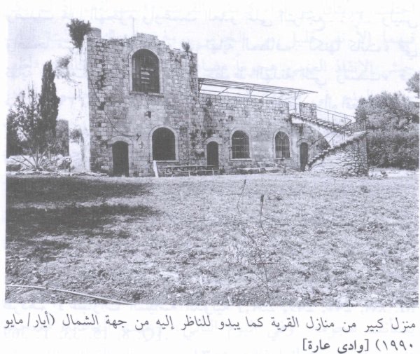
The village had a rectangular plan extending from east to west. Its houses were clustered together and built of stone held with either mud or cement mortar.
Daliyat al-Rawha' stood on a small hill between two shallow wadis running north to south. A secondary road linked it to a main highway leading southwest toward the Mediterranean and northeast toward Marj ibn Amir.
A khirba stood northwest of the village, although the principal sources used here do not provide sufficient evidence to date all of its remains.
Population of Daliyat al-Rawha'
The Palestinian residents of Daliyat al-Rawha' were Muslims. The 1944/45 figures require particular care because the statistical unit included the Jewish settlement of Dalia; the total of 600 therefore should not be presented as the Palestinian population of the village itself.
- 1922135Official Census of Palestine, 1922
- 1931163Official Census of Palestine, 1931
- 1944/1945280 ArabsPalestinian population in the statistical unit; the total of 600 also included 320 Jewish residents of Dalia
- 1948325Later Palestinian population estimate published by Palestine Remembered; not an official census
- 19981,995 refugeesLater estimate of refugees and descendants; not an official census
Number of Houses
- 193146 housesOfficial census
- 194891 housesLater estimate published by Palestine Remembered
Land Ownership in Daliyat al-Rawha'
The statistical unit containing Daliyat al-Rawha' and Dalia covered a total of 10,008 dunums. Palestine Remembered presents the simplified ownership categories as follows:
- Palestinian178 dunums2%
- Transferred to Zionists9,614 dunums96%
- Communal/Public216 dunums2%
The official 1944/45 Village Statistics use the categories Arab, Jewish, and Public, listing 178 Arab dunums, 9,614 Jewish dunums, and 216 public dunums. These figures include Dalia.
Land Use in 1944/1945
- Arab
- Jewish
- Public
- Cereals9,651 dunums
- Plantations and Irrigable Land98 dunums
- Built-up Area43 dunums
- Non-Cultivable Land216 dunums
The categories add correctly to the total land area of 10,008 dunums. Cultivated or cultivable land amounted to 9,749 dunums, while built-up and non-cultivable land together accounted for 259 dunums.
Economic Life in Daliyat al-Rawha'
The Palestinian inhabitants depended on agriculture and animal husbandry. By 1944/45, however, the land remaining in Arab ownership within the statistical unit was limited relative to the area already classified under Jewish ownership.
Palestinian farmers allocated 56 dunums to cereals and 98 dunums to irrigated land or orchards. Livestock raising was another component of the village economy.
Water Resources
The inhabitants obtained water from the numerous springs surrounding the village. The nineteenth-century Survey of Western Palestine specifically mentioned a good spring south of the settlement.
Education in Daliyat al-Rawha'
The principal sources used for this article do not provide sufficiently documented information about an independent village school, its establishment date, or its enrollment. No unsupported school date or student figure is therefore supplied.
Occupation and Depopulation of Daliyat al-Rawha'
Daliyat al-Rawha' passed through more than one stage of displacement and occupation, and its history cannot accurately be reduced to a single date.
Walid Khalidi, discussing an account attributed to Benny Morris, states that by the eve of the Nakba much of the village land had already been acquired by Zionist organizations and that the Palestinian residents were living as tenant farmers. In January 1948, officials of the Jewish National Fund discussed the fate of Daliyat al-Rawha' and similar communities.
According to the same account, in February 1948 Yosef Weitz used contacts with local Haganah units and Haganah intelligence officers to have tenant farmers removed from several villages, including Daliyat al-Rawha'. The principal displacement of the Palestinian villagers therefore preceded the later documented military occupation of the site.
The village site itself was reportedly occupied on 14 April 1948 during the fighting around Mishmar HaEmek. A contemporary report cited by Khalidi stated that Daliyat al-Rawha' was among a group of villages captured in an arc south of the settlement.
Palestine Remembered separately displays 1 March 1948 as an occupation date in its summary field. Its detailed historical narrative, however, distinguishes between the February eviction and the military occupation on 14 April. The 1 March date is therefore not treated here as an independently established final occupation date.
Occupation Chronology
- January 1948
Discussion of the Villagers' Fate
Jewish National Fund officials discussed the future of Daliyat al-Rawha' and similar tenant-farming communities.
- February 1948
Expulsion of Palestinian Residents
According to the account reproduced by Khalidi, local Haganah units and intelligence contacts were used to remove tenant farmers from the village.
- 1 March 1948
Conflicting Database Date
This appears as the occupation date in a Palestine Remembered summary field but conflicts with the detailed chronology that places military occupation in April.
- 14 April 1948
Occupation of the Village Site
Daliyat al-Rawha' was occupied during the fighting around Mishmar HaEmek.
- By mid-June 1948
Complete Destruction Documented
The historical account states that the village had been completely destroyed by this time.
Battle of Mishmar HaEmek and Military Unit
Military Context: The occupation of Daliyat al-Rawha' took place during the final phase of the fighting around Mishmar HaEmek in April 1948, when Haganah forces took control of a number of Palestinian villages in the surrounding area.
Military Unit: Haganah. The village-specific historical entry does not independently identify the battalion or brigade that entered Daliyat al-Rawha' on 14 April, so no more specific unit is assigned without village-level documentation.
Cause of Depopulation
The depopulation of Daliyat al-Rawha' occurred in more than one stage. The February eviction of Palestinian tenant farmers preceded the military occupation of the village site in April. Palestine Remembered classifies the cause of departure as a direct military assault.
Destruction of Daliyat al-Rawha'
The historical material reproduced by Khalidi indicates that the destruction of the village was complete by mid-June 1948. The principal sources do not establish the exact day on which the demolition itself took place.
Settlements on Daliyat al-Rawha' Village Lands
Dalia was established in 1939 south of the Palestinian village site on land that had originally belonged to Daliyat al-Rawha'. It was therefore established before the Nakba on part of the village lands.
Ramot Menashe, established on 31 July 1948, was attributed in one account to Daliyat al-Rawha' land. Khalidi, however, corrects this and states that Ramot Menashe actually stands on land belonging to neighboring Sabbarin. It is therefore not listed here as a settlement established on Daliyat al-Rawha' village land.
Daliyat al-Rawha' Today
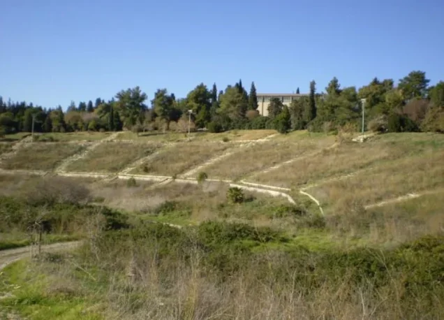
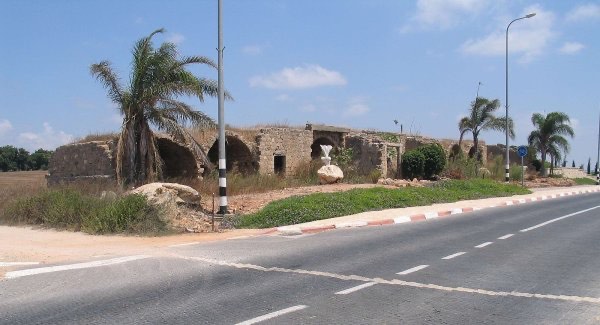
According to Walid Khalidi's field description documented before the publication of All That Remains in 1992, stone rubble from village houses remained visible beneath soil, grass, bushes, and thorny vegetation. Large clusters of cactus covered substantial parts of the site, while several olive, chinaberry, and poplar trees remained scattered across it.
A large eucalyptus stood at the southern edge. Stones among the cactus plants nearby were thought to represent the remains of the village cemetery, while walls from a house with a stone floor survived in the wadi at the southern edge of the site.
This is historical field documentation from the period preceding the book's publication in 1992 and should not be treated as direct verification of conditions in 2026.
Palestine Remembered also published a community documentation page on 22 August 2026 containing a filmed visit to the Daliyat al-Rawha' site. The publication date does not necessarily establish the recording date, however, so this material is best treated as later community documentation rather than an independent comprehensive field survey of the site in 2026.
Sources
- PalQuest – Interactive Encyclopedia of the Palestine Question: Daliyat al-Rawha'
- Palestine Remembered – Daliyat al-Rawha', Haifa District
- Palestine Remembered – Historical account of Daliyat al-Rawha' from Walid Khalidi's All That Remains
- Palestine Remembered – Later community documentation of Daliyat al-Rawha', published August 2026
- Government of Palestine – Census of Palestine, 1922
- Birzeit University Repository – Census of Palestine, 1931, E. Mills
- Sami Hadawi – Village Statistics 1945, reproducing Government of Palestine statistics
Photo gallery
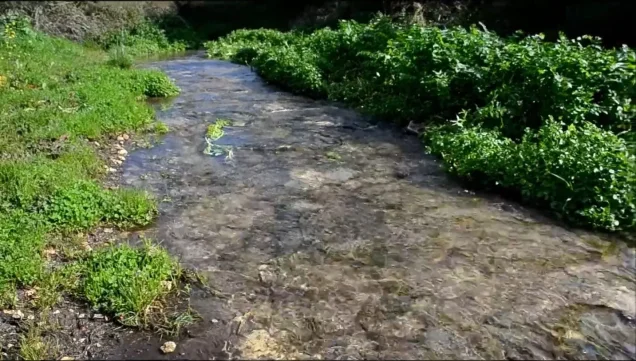
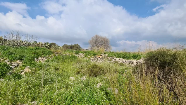

Photos from the village's people
Photos sent in by visitors and published after review.
Add a photo of this village
Log in to add photos of this village.
Other villages from Haifa
More from the archive



 Download Our Palestine App
The whole archive in the palm of your hand: depopulated villages, the Nakba, the massacres and Al-Aqsa — free, with no ads to erase the story.
Download Our Palestine App
The whole archive in the palm of your hand: depopulated villages, the Nakba, the massacres and Al-Aqsa — free, with no ads to erase the story.



Comments
No comments yet — be the first to write one.
Add your comment
Name and email are optional. Comments appear after review.