
The depopulated village of Sabbarin / District of Haifa
Sabbarin
About the depopulated village of Sabbarin
- District
- Haifa
- Date Sabbarin was occupied
- 12 May 1948
- Population in 1948
- 1,970
- Military operation
- Coastal Clearing
- Elevation above sea level
- 100 m
Hover a dot to read the village name, or click to open its card.
Borders of the depopulated village of Sabbarin
Depopulated Palestinian Village in Haifa Subdistrict
Sabbarin was a Palestinian village in the Haifa subdistrict, situated in the Bilad al-Rawha region south of Haifa. The village stood on both sides of Wadi al-Tin at an average elevation of about 100 meters above sea level. PalQuest gives its distance from Haifa as approximately 28 kilometers, the figure adopted in this article.
Sabbarin had a population of 1,700 in the official 1944/45 statistics, while its registered lands covered 25,307 dunums. During the Nakba and the events surrounding the 1948 occupation of Palestine, Etzel, also known as the Irgun, attacked Sabbarin on 12 May 1948. Most villagers fled during the assault, while residents who remained were subsequently detained and expelled.
Key Facts about Sabbarin
| Field | Information |
|---|---|
| Village | Sabbarin |
| Subdistrict | Haifa |
| Status | Depopulated Palestinian village |
| Distance from Haifa | Approximately 28 km |
| Elevation | Approximately 100 m above sea level |
| Region | Bilad al-Rawha, on both sides of Wadi al-Tin |
| Population, 1944/45 | 1,700 |
| Registered land area | 25,307 dunums |
| Date of attack and occupation | 12 May 1948 |
| Military operation | “Coastal Clearing,” according to Palestine Remembered |
| Direct attacking force | Etzel / Irgun |
| Cause of depopulation | Military assault followed by the expulsion of those who remained |
| Settlements established on village lands | Ramot Menashe (1948) and Amikam (1950) |
The principal geographical and statistical data are recorded by PalQuest – Sabbarin. Identification of Etzel/Irgun as the force that directly attacked the village on 12 May is supported by Palestinian historian Mustafa Kabha's study reproduced by Palestine Remembered.
Location and Neighboring Villages
Sabbarin lay in the western part of Bilad al-Rawha and belonged administratively to the Haifa subdistrict during the British Mandate. Wadi al-Tin crossed the village from north to south, and secondary roads linked it with the Haifa–Jenin highway and the main coastal road.
Mustafa Kabha identifies al-Sindiyana and Burayka to the west; Qannir and Kafr Qari' to the south and southeast; Umm al-Shawf and Khubbayza to the east; and Umm al-Dufuf and Daliyat al-Rawha to the northeast. Sabbarin also lay east of Zammarin.
The Name Sabbarin
Mustafa Kabha suggests that the village name was probably connected with the abundance of cactus plants in the area. Walid Khalidi notes that Crusader sources used forms resembling Sabbarim or Sabarim. The cactus derivation is therefore best presented as a plausible interpretation rather than as a proven etymology.
Sabbarin before the Nakba
The late nineteenth-century Survey of Western Palestine described Sabbarin as a large village situated on a slope, with houses built of stone and mud. Walid Khalidi reproduces an estimate of roughly 600 inhabitants for that period.
The village expanded during the British Mandate. Its residents depended principally on agriculture and animal husbandry, supported by the numerous springs and streams of the surrounding area. By the eve of the Nakba, Sabbarin was one of the larger Palestinian communities in Bilad al-Rawha.
Population of Sabbarin
- Late 19th centuryAbout 600Historical estimate from the Survey of Western Palestine
- 1922845Official British Mandate census
- 19311,108Official British Mandate census
- 1944/451,700Official statistics; 1,670 Muslims and 30 Christians
- 19481,972Later estimate reported by Palestine Remembered, not an official census
- 199812,110 refugeesLater refugee estimate reported by Palestine Remembered
PalQuest confirms the 1931 and 1944/45 figures, while Palestine Remembered also reports the 1922 figure and the later 1948 and 1998 estimates.
Number of Houses
- 1931256Official 1931 census figure
- 1948455Later estimate reported by Palestine Remembered
The estimate of 455 houses in 1948 should not be presented as an official census figure.
Land Ownership in Sabbarin
Sabbarin's registered land area in the 1944/45 statistics totaled 25,307 dunums. Using the land-ownership terminology employed by Palestine Remembered:
- Palestinian19,840 dunums78%
- Transferred to Zionists4,209 dunums17%
- Communal/Public1,258 dunums5%
The figures are internally consistent: 19,840 + 4,209 + 1,258 = 25,307 dunums.
Land Use in 1944/45
For official land-use statistics, the original categories Arab / Jewish / Public should be retained rather than merged with the simplified ownership categories above.
- Arab
- Jewish
- Public
- Cereals16,873 dunums
- Plantations and irrigable land154 dunums
- Built-up area179 dunums
- Non-cultivable land8,101 dunums
This breakdown corrects a potentially misleading presentation in the simplified Palestine Remembered table: the 8,101 dunums of non-cultivable land consisted of 6,843 Arab dunums and 1,258 Public dunums, according to PalQuest.
Palestine Remembered separately records five dunums of olive cultivation. This is treated here as a crop detail rather than as an additional land category and is therefore not added again to the total.
Economic Life in Sabbarin
Sabbarin's economy depended primarily on agriculture and animal husbandry. Villagers cultivated cereals, vegetables, and olives and benefited from the abundance of water in the surrounding area. In 1944/45, 12,773 dunums of Arab-held land were devoted to cereals and 45 dunums were classified as irrigated or plantation land.
Animal husbandry was another documented element of the village economy, supported by the surrounding pasture and water resources.
Water Resources
Sabbarin and its surroundings were noted for numerous springs and streams. Mustafa Kabha records local water sources including 'Ayn al-Balad, 'Ayn al-Hajja, 'Ayn Abu Halawa, 'Ayn al-Fawwar, 'Ayn al-Balata, and 'Ayn Abu Shaqir, as well as local watercourses.
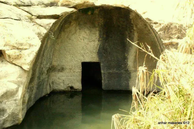
West of the village stood a substantial masonry water structure that Walid Khalidi identifies as the head of the Roman high-level aqueduct leading toward Caesarea. It drew water from springs in the vicinity of Sabbarin.
Education in Sabbarin
Sabbarin had a boys' elementary school. Palestine Remembered also preserves references to administrative correspondence and teacher appointments connected with the school during the 1930s and 1940s.
These records document the existence and operation of the school, but they should not be used to invent a precise founding date unless a document explicitly identifies one.
Archaeological Remains
The sources record old foundations and a well in the village area, together with limited archaeological remains. The most prominent water-related feature was the masonry installation identified as the head of the Roman high-level aqueduct leading toward Caesarea.
Walid Khalidi notes that published archaeological surveys provided only limited evidence concerning the antiquity of the settlement, so the remains should not be assigned a more specific historical interpretation than the evidence supports.
Sabbarin during the 1936–1939 Palestinian Revolt
According to Palestinian historian Mustafa Kabha, Sabbarin was an active center of the 1936–1939 Palestinian Revolt in the Bilad al-Rawha and Carmel region. A local armed group led by Ibrahim al-Khawaja operated from the village and was connected with regional revolt commanders.
Occupation and Depopulation of Sabbarin
During late 1947 and early 1948, efforts were made to organize defensive positions in Sabbarin and neighboring villages. Mustafa Kabha writes that Arab Liberation Army officers came to Sabbarin in late January 1948 and met the mukhtars of several Bilad al-Rawha villages to discuss local defense and arms training.
On 12 May 1948, Etzel/Irgun forces attacked a group of villages in the area, with a substantial part of the attacking force concentrated around Sabbarin. Kabha documents armed resistance during the advance, followed by a large-scale flight of villagers eastward under fire.
Palestine Remembered classifies the attack under “Coastal Clearing” and gives 12 May 1948 as the date on which the village was occupied.
Residents who remained—including elderly people, women, children, and others unable to flee—were detained before being removed from the village. Accounts discussed by Kabha indicate that they were sent toward Umm al-Shawf and then Umm al-Fahm. The testimonies differ on whether detention lasted several hours or several days.
Occupation Chronology
- Late January 1948
Defensive preparations
Arab Liberation Army officers met mukhtars from Sabbarin and neighboring Bilad al-Rawha villages to discuss defensive organization.
- 12 May 1948
Main assault
Etzel/Irgun forces attacked Sabbarin and encountered resistance during their advance.
- 12 May 1948
Large-scale flight
Most villagers fled eastward while the assault was under way.
- 12 May 1948
Occupation
One testimony analyzed by Kabha places the completion of the military capture during the morning.
- 12 May and immediately afterward
Detention of remaining residents
Elderly people, women, children, and other remaining residents were detained; accounts differ over their number and the length of detention.
- Immediately after occupation
Expulsion
The remaining detainees were removed toward Umm al-Shawf and then Umm al-Fahm.
- Several days later
Transfer to Haganah control
Kabha reports that the Etzel unit remained briefly before handing the village over to Haganah forces.
- Precise date not established in the principal sources reviewed
Destruction
Most village structures were ultimately destroyed, but the material reviewed does not establish a precise demolition date.
Killings and Detention during the Capture of Sabbarin
The available testimonies differ substantially over the number of people killed. Mustafa Kabha cites one account by an attacking commander referring to more than twenty deaths during the fighting, while another officer's testimony gives a figure of 80. The same accounts also disagree over the number of detainees and the duration of their detention.
A Sabbarin eyewitness whose testimony is discussed by Kabha described civilian deaths during the entry of the attacking forces and also gave an account of elderly and infirm residents being gathered in a structure that was then set on fire. Because of the major discrepancies among the testimonies, no single casualty figure should be presented as definitively established.
Palestine Remembered describes the events as a massacre and classifies Sabbarin's complete depopulation as ethnic cleansing. In directly descriptive terms supported across the accounts, the military assault caused most residents to flee, while remaining villagers were detained and subsequently expelled.
Sabbarin's Refugees after the Nakba
Mustafa Kabha reports that many refugees from Sabbarin eventually lived in the West Bank and Jordan, while others reached Syria, Lebanon, and other places. A portion of the displaced community remained inside Palestine and settled in localities including Fureidis, 'Ara, 'Ar'ara, Barta'a, Umm al-Fahm, and Mu'awiya.
Israeli Settlements on Sabbarin's Lands
PalQuest and Walid Khalidi identify two Israeli settlements established on Sabbarin's lands:
| Settlement | Established | Location in Relation to Sabbarin |
|---|---|---|
| Ramot Menashe | 1948 | On Sabbarin's lands, northeast of the village site |
| Amikam / Ammiqam | 1950 | On Sabbarin's lands, about one kilometer from the village site |
Sources: PalQuest – Sabbarin and Walid Khalidi, All That Remains.
Sabbarin Today
In Walid Khalidi's field description, the extensive village site was overgrown with wild thorns and scattered with the stone rubble of destroyed houses. Cactus plants and pine, fig, olive, and mulberry trees remained at the site, while parts of the surrounding land were used for pasture and fruit cultivation.
Palestine Remembered identifies photographs associated with Khalidi's documentation as dating to 1987. The description therefore reflects field documentation undertaken before the publication of All That Remains in 1992 and should not be presented as a direct field verification of conditions at the site in 2026.
Sources
Photo gallery


Photos from the village's people
Photos sent in by visitors and published after review.
Add a photo of this village
Log in to add photos of this village.
Other villages from Haifa


More from the archive


 Download Our Palestine App
The whole archive in the palm of your hand: depopulated villages, the Nakba, the massacres and Al-Aqsa — free, with no ads to erase the story.
Download Our Palestine App
The whole archive in the palm of your hand: depopulated villages, the Nakba, the massacres and Al-Aqsa — free, with no ads to erase the story.



Comments
No comments yet — be the first to write one.
Add your comment
Name and email are optional. Comments appear after review.