
The depopulated village of Khirbat Sa'sa' / District of Haifa
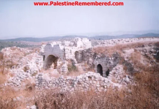
Khirbat Sa'sa'
About the depopulated village of Khirbat Sa'sa'
- District
- Haifa
- Date Khirbat Sa'sa' was occupied
- 28 April 1948
- Population in 1948
- 150
- Distance from the governorate centre
- 15 (km) East of Haifa
- Elevation above sea level
- 50 m
- Extent of destruction
- The village has been completely destroyed, and only house rubble left behind.
- Ethnic cleansing
- Sa'sa', Khirbat inhabitants were completely ethnically cleansed.
Hover a dot to read the village name, or click to open its card.
Borders of the depopulated village of Khirbat Sa'sa'
Khirbat Sa'sa' – Depopulated Palestinian Village of the Haifa Subdistrict
Khirbat Sa'sa' was a Palestinian village in the Haifa Subdistrict and should not be confused with Sa'sa', the much larger Palestinian village in the Safad Subdistrict. Khirbat Sa'sa' stood on a low, rounded mound overlooking the eastern edge of the Haifa Plain, approximately 15 km east of Haifa and about 50 metres above sea level.
During the British Mandate it was classified as a hamlet in the Palestine Index Gazetteer. Its separately recorded population in 1944/45 was 130.
Khirbat Sa'sa' and Sa'sa' of Safad
Khirbat Sa'sa' in the Haifa Subdistrict was a distinct locality from Sa'sa' in the Safad Subdistrict. The latter was a large Upper Galilee village, whereas Khirbat Sa'sa' was a small rural settlement east of Haifa in the Shafa 'Amr area.
Population figures, land statistics, military events, and post-1948 settlements belonging to Sa'sa' of Safad must therefore not be transferred to Khirbat Sa'sa'.
Location
Khirbat Sa'sa' stood on a slightly elevated, rounded mound overlooking the eastern edge of the Haifa Plain, approximately 15 km east of Haifa and at an average elevation of about 50 metres above sea level.
The hamlet formed part of the wider rural zone associated administratively and statistically with Shafa 'Amr during the Mandate period.
History and Archaeological Remains
Scholars have identified the site with the Roman-period locality Kefar Sasai, which lay near the ancient boundary between Ptolemais (Acre) and Sepphoris, later the Palestinian town of Saffuriyya.
On this basis, Walid Khalidi considers it likely that at least some of the ruins visible at Khirbat Sa'sa' dated to the early centuries CE.
The site contained building foundations, rock-cut tombs, cisterns, and caves. South of the village stood Khirbat Jabyatha, an archaeological mound from which sections of an old wall were visible.
The available evidence does not establish that every surviving feature belonged to the same Roman-period phase, so the individual remains are not all assigned to a specific date.
Population of Khirbat Sa'sa'
The 1931 census requires particular caution because Khirbat Sa'sa' was not published as a separate population unit.
- 19311,197Official combined figure, not a separate count for Khirbat Sa'sa'. It included Wa'arat al-Sarris, 'Arab al-Hilf, 'Arab al-Madabigh, Ras 'Ali, 'Arab Murairiya, 'Arab al-Zubaidat, 'Arab al-Majadib, Ard al-Tuwal, and Mathanat Kurdana.
- 1944/45130Official figure separately identifying Khirbat Sa'sa' within the list of communities making up rural Shafa 'Amr.
- 1948151Later Palestine Remembered estimate, not an official census.
- 1998926 refugeesLater Palestine Remembered estimate of the village refugee population and descendants.
Number of Houses
The 1931 census records 234 houses for the same combined statistical unit containing 1,197 inhabitants. This was not a separate house count for Khirbat Sa'sa'.
The principal sources reviewed do not provide a securely documented independent number of houses for Khirbat Sa'sa' itself in 1931 or immediately before the Nakba.
Village Lands
The Government of Palestine's 1944/45 statistics do not publish an independent land-ownership table for Khirbat Sa'sa'. Its land was included within the much larger statistical unit designated Shafa 'Amr (Rural).
Rural Shafa 'Amr as a whole covered 97,268 dunums in the official statistics, but that total encompassed numerous separate communities and cannot be attributed to Khirbat Sa'sa'. The published table does not provide a reliable means of extracting the village's individual share.
For this reason, no Palestinian / Transferred to Zionists / Communal-Public ownership table is presented for Khirbat Sa'sa'. Doing so would imply a level of statistical precision that the official source does not provide.
Land Use
The same limitation applies to land use. The official cereal, plantation, irrigated, built-up, and non-cultivable figures are tabulated for rural Shafa 'Amr as a whole rather than for Khirbat Sa'sa' separately.
Those aggregate figures are therefore not transferred to Khirbat Sa'sa' and no village-specific numerical land-use table is created without an independent source.
Economic Life
Khalidi's village-specific entry does not provide enough information to establish particular crops, crafts, markets, or commercial activities belonging specifically to the inhabitants of Khirbat Sa'sa'.
Because official land-use figures were combined with those of rural Shafa 'Amr, regional agricultural statistics are not presented as though they were independent data for this hamlet.
Water, Education, and Public Services
The ancient cisterns at the site attest to a long history of water storage, but the principal sources used here do not provide a documented account of the hamlet's water system immediately before the Nakba.
The same sources do not securely document a formal school, mosque, or other specific public institution in Khirbat Sa'sa' before 1948. No unsupported details are therefore added.
Occupation and Depopulation
Walid Khalidi does not establish a precise day for the occupation of Khirbat Sa'sa'. The village lay in an area where some communities had already been taken in the early weeks of the war, while most neighboring localities were occupied after the fall of Haifa during the final week of April 1948.
Khalidi concludes that if Khirbat Sa'sa' remained unoccupied until late April, it was probably captured at that time by Haganah units seeking to consolidate their hold over Haifa and its rural hinterland.
Palestine Remembered lists 28 April 1948 as the occupation date. This fits Khalidi's broader late-April timeframe, but it is more precise than the detailed village narrative itself, so it is treated as a database date rather than an independently established exact day.
Was Khirbat Sa'sa' Occupied During Operation Bi'ur Hametz?
Palestine Remembered labels the associated military operation as “possibly Bi'ur Hametz.”
Operation Bi'ur Hametz, however, ran from 22 to 24 April 1948. PalQuest identifies Umm al-Zinat, Khirbat al-Mansura, and al-Rihaniyya among the villages affected by that operation and does not list Khirbat Sa'sa'.
Furthermore, the 28 April occupation date supplied by Palestine Remembered falls four days after the formal end of Bi'ur Hametz.
There is therefore insufficient evidence to attribute the occupation of Khirbat Sa'sa' directly to Operation Bi'ur Hametz. The stronger formulation is that Haganah forces probably took the village in the final week of April during the broader consolidation of Zionist control over the Haifa region after the city's fall.
Military Unit
Khalidi identifies the attacking force only at the general level as Haganah units. He does not independently identify the brigade or battalion that entered Khirbat Sa'sa'.
The village should therefore not automatically be attributed to the Carmeli Brigade merely because that brigade operated extensively in the Haifa region.
The most precise formulation is: Military force: Haganah units; named village-specific operation: not securely established; probable occupation period: the final week of April 1948.
Occupation Chronology
- 21–22 April 1948
Fall of Haifa
The fall of Haifa was followed by expanded Haganah operations in the Palestinian rural hinterland surrounding the city.
- 22–24 April 1948
Operation Bi'ur Hametz
A Haganah operation in the Haifa hinterland, but PalQuest does not list Khirbat Sa'sa' among its documented affected villages.
- Final week of April 1948
Probable occupation period
Khalidi considers it likely that Haganah units took the village while consolidating their control over Haifa and the surrounding region.
- 28 April 1948
Palestine Remembered date
Listed by the database as the occupation date, although Khalidi's detailed village entry does not independently establish this exact day.
Israeli Settlements on Khirbat Sa'sa' Village Lands
Walid Khalidi identifies no Israeli settlement established on Khirbat Sa'sa' village land.
After the Nakba, the village lands were incorporated into the lands of the Arab town of Shafa 'Amr. Nearby Israeli localities should therefore not be classified as settlements on Khirbat Sa'sa' land without direct documentary evidence.
Khirbat Sa'sa' Today
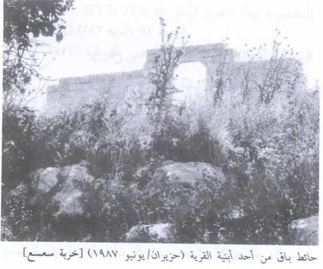
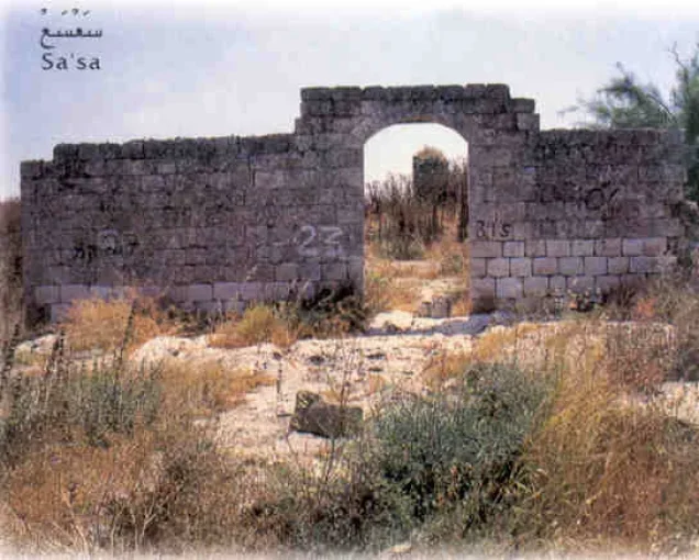
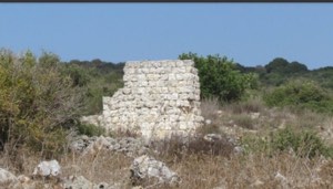
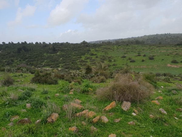
In the field description published by Walid Khalidi in All That Remains, fig trees and cactus plants were scattered across the village site. Several partially collapsed stone walls remained, including one containing a large arched opening.
The surrounding lands were being used for grazing.
Palestine Remembered reproduces a photograph from the All That Remains field documentation labelled 1987, as well as later community-contributed material. Upload dates and later contributions should not automatically be treated as dates of a systematic field survey.
Khalidi's description itself derives from fieldwork conducted before the publication of All That Remains in 1992 and does not constitute direct and comprehensive verification of the site's condition in 2026.
Sources
- PalQuest – Khirbat Sa'sa'
- PalQuest – Operation Bi'ur Hametz
- Palestine Remembered – Khirbat Sa'sa', Haifa
- Palestine Remembered – Khirbat Sa'sa' entry from Walid Khalidi's All That Remains
- Institute for Palestine Studies – Walid Khalidi, All That Remains
- Sami Hadawi – Village Statistics 1945, Haifa Subdistrict table
Photo gallery
Photos from the village's people
Photos sent in by visitors and published after review.
Add a photo of this village
Log in to add photos of this village.
Other villages from Haifa

More from the archive


 Download Our Palestine App
The whole archive in the palm of your hand: depopulated villages, the Nakba, the massacres and Al-Aqsa — free, with no ads to erase the story.
Download Our Palestine App
The whole archive in the palm of your hand: depopulated villages, the Nakba, the massacres and Al-Aqsa — free, with no ads to erase the story.



Comments
No comments yet — be the first to write one.
Add your comment
Name and email are optional. Comments appear after review.