
The depopulated village of Khubbayza / District of Haifa
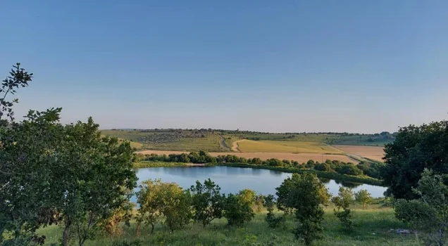
Khubbayza
About the depopulated village of Khubbayza
- District
- Haifa
- Date Khubbayza was occupied
- 12 May 1948
- Population in 1948
- 336
- Military operation
- No named operation; an Irgun attack on villages of the area in the weeks after the battle of Mishmar ha-Emeq (April 1948)
- Brigade that carried it out
- Irgun
- Distance from the governorate centre
- 29.5 km from Haifa
- Elevation above sea level
- 175 m
- Cause of displacement
- Direct military assault by Zionist forces (the Irgun) under mortar fire, followed by the expulsion of the inhabitants who had been detained
- Extent of destruction
- The village has been completely destroyed, and only house rubble left behind.
- Ethnic cleansing
- Khubbayza inhabitants were completely ethnically cleansed.
- Settlements built on the built-up area of Khubbayza after 1948
- There are no Israeli settlements on village lands, according to Khalidi; the closest settlement is Even Yitzchaq, founded in 1945 on lands that belonged to the village of al-Butaymat, about 1 km east of the village site
Hover a dot to read the village name, or click to open its card.
Borders of the depopulated village of Khubbayza
Khubbayza – A Depopulated Palestinian Village in the Haifa Subdistrict
Khubbayza was a Palestinian village in the Haifa Subdistrict, situated in Bilad al-Rawha approximately 29.5 km southeast of Haifa, at an average elevation of about 175 meters above sea level.
The village stood on hilly ground sloping toward the southwest, approximately one kilometer south of Wadi al-Sindiyana. Two secondary roads, one leaving from the north and another from the south, connected it with the main road linking the coast with the Marj ibn 'Amir plain.
Khubbayza was occupied by the Irgun during the Nakba and the occupation of Palestine in 1948. Walid Khalidi places its capture between 12 and 14 May 1948, during an Irgun offensive against Palestinian villages in Bilad al-Rawha. Mortar fire contributed to the flight of much of the population, while some Palestinians who remained were detained and later expelled.
- Subdistrict
- Haifa
- Region
- Bilad al-Rawha
- Distance from Haifa
- 29.5 km from Haifa
- Elevation
- 175 m above sea level
- Population in 1931
- 209
- Number of Houses in 1931
- 42
- Population, 1944/45
- 290
- Estimated Population in 1948
- About 336 – a later demographic estimate, not an official census
- Total land area
- 4,854 dunams
- Attack and Depopulation
- Khalidi considers it probable that the village was the victim of an early Haganah raid on 1 January 1948. It fell to the Irgun between 12 and 14 May 1948; most of the inhabitants of the region fled under mortar fire, and many were kept for a few days behind barbed wire and then expelled.
- Final Israeli Control
- Between 12 and 14 May 1948, according to Khalidi; the sources do not give the exact day
- Military Operation
- No named operation in the sources; the village fell in an Irgun attack on villages of the area in the weeks following the battle of Mishmar ha-Emeq (April 1948), according to Khalidi
- Military Unit
- The Irgun (IZL), according to Khalidi
- Date of occupation and depopulation
- 12–14 May 1948
- Military force
- Irgun (IZL / Etzel)
- Cause of depopulation
- Direct military assault by Zionist forces (the Irgun) under mortar fire, followed by the expulsion of the inhabitants who had been detained
- Israeli settlements confirmed by Khalidi as established on village land
- There are no Israeli settlements on village lands, according to Khalidi; the closest settlement is Even Yitzchaq, founded in 1945 on lands that belonged to the village of al-Butaymat, about 1 km east of the village site
Location and Geography of Khubbayza
Khubbayza stood amid hilly terrain descending toward the southwest, about one kilometer south of Wadi al-Sindiyana. Two secondary roads connected it with the main road between the Mediterranean coast and Marj ibn 'Amir.
A later local Palestinian study places Umm al-Shawf and al-Sindiyana to the west, al-Butaymat and al-Kafrayn to the east, Qannir, Kafr Qari', and 'Ara to the south, Daliyat al-Rawha to the north, and Sabbarin to the northwest.
These directions should be treated as approximate local geographical descriptions rather than substitutes for detailed cadastral boundary maps.
Name of the Village
The name Khubbayza derives from the Arabic word for mallow, a wild plant commonly cooked as a vegetable in Palestinian rural cuisine.
Local documentation states that the formal Mandate-era form was “al-Khubbayza,” while residents commonly shortened the name to “Khubbayza.”
Khubbayza in the Nineteenth Century
Nineteenth-century estimates of Khubbayza's population vary between travelers and surveys. Khalidi reproduces an estimate of approximately 270 inhabitants cultivating about 24 faddans of land.
The Survey of Western Palestine described it as a village of moderate size on elevated ground, with wells in the valley to the south.
The village extended on a northeast–southwest axis, and its stone-built houses were clustered relatively closely together.
Population of Khubbayza
The official 1922 Census of Palestine recorded 140 inhabitants in Khubbayza, all Muslims.
By the official 1931 census, the population had increased to 209, again all Muslims, living in 42 occupied houses.
The 1944/45 Village Statistics recorded 290 Arabs.
Palestine Remembered later estimated the population at 336 in 1948 and the number of refugees and their descendants at 2,066 in 1998. These latter figures are retrospective estimates rather than official Mandate census counts.
- 1922140Official census; all Muslims
- 1931209Official census; all Muslims
- 1944/45290Official British Mandate statistics
- 1948336Later Palestine Remembered estimate, not an official census
- 19982,066 refugeesLater estimate of refugees and their descendants
Number of Houses
- 193142Occupied houses recorded in the official census
- 194867Later estimate reported by Palestine Remembered
Land Ownership in Khubbayza
The total land area of Khubbayza in the 1944/45 statistics was 4,854 dunums. Palestine Remembered presents the simplified ownership categories as follows:
- Palestinian2,828 dunums58%
- Transferred to Zionists2,024 dunums42%
- Communal/Public2 dunums<1%
The official Village Statistics use the categories Arab, Jewish, and Public: 2,828 dunums were classified as Arab, 2,024 as Jewish, and 2 as public land.
Land Use in 1944/45
- Arab
- Jewish
- Public
- Plantations and irrigable land68 dunums
- Cereals4,316 dunums
- Built-up land11 dunums
- Non-cultivable land459 dunums
Cultivable land totaled 4,384 dunums, comprising 2,360 Arab dunums and 2,024 Jewish dunums—approximately 90 percent of the village lands.
Non-cultivable land totaled 459 dunums: 457 Arab and 2 public. The entire 459-dunum figure should therefore not be assigned to Palestinian private ownership.
Sources record 20 dunums planted with olive trees. These were included within the 65 Arab dunums classified as plantations and irrigable land and should not be added again to the total cultivable acreage.
Economic Life in Khubbayza
Agriculture and livestock raising formed the principal basis of village life. Cereals, vegetables, and olives were among the most important crops.
In 1944/45, cereal land totaled 4,316 dunums across all ownership categories: 2,295 Arab dunums and 2,021 Jewish dunums.
Plantations and irrigable land covered another 68 dunums, of which 65 were Arab and 3 Jewish.
Local historical documentation also records wheat, barley, maize, lentils, sesame, figs, pomegranates, grapes, and almonds, as well as sheep and cattle. These more detailed crop descriptions derive from local and oral-history documentation rather than the official land-use table itself.
Water
The inhabitants obtained domestic water from a number of springs and wells within the boundaries of Khubbayza.
Local documentation preserves names such as 'Ayn al-'Arayis, 'Ayn al-'Asal, Umm al-Nab'at, Bi'r Abu Hajwa, Bi'r Muhammad, and the western spring, along with privately owned wells.
These names belong to local historical documentation; Khalidi's principal village entry more generally confirms the presence of several springs and wells.
Mosque, Education, and Services
Khalidi's village entry does not provide detailed information about a school or mosque, but a later local study based on testimony from former inhabitants preserves additional information.
According to this local documentation, Khubbayza had a simple mosque approximately 10 by 7 meters in size, accommodating around seventy worshippers.
The village did not have a formal government school during the Mandate period. Children learned Qur'an and Arabic in a house donated for instruction. In 1947, some pupils began attending the school in Umm al-Shawf, while others studied in Sabbarin.
The same local source records two small shops and four family diwans used for receiving guests and community gatherings.
Archaeological Remains
Khirbat al-Kalba, or Khirbat al-Kalbi, lay north of the village. Khalidi records that its name was probably connected with the Arab tribe of Banu Kalb and that it contained traces of a former settlement.
Local studies identify additional sites around Khubbayza, including Khirbat Abu Hajwa, Khirbat al-'Arayis, and Khirbat al-Faras, as well as the remains of a water-powered grain mill.
A local study argues for continuous occupation of the broader area from prehistoric times to 1948. The principal Khalidi/PalQuest entry, however, establishes only the presence of archaeological traces at Khirbat al-Kalba. It is therefore safer to state that the area contains remains from multiple historical periods rather than claim uninterrupted settlement across all of them.
Possible January 1948 Raid
Khalidi cautiously suggests that Khubbayza may have been the target of an early Haganah raid during the first weeks of the war.
On 1 January 1948, the New York Times reported an attack on a village it called “Habassa near Haifa,” comparing it with the attack on Balad al-Shaykh on the same day.
The identification of “Habassa” with Khubbayza is not certain in Khalidi's account, so this event is best treated as a possible early raid rather than a firmly established attack on the village.
Occupation and Depopulation of Khubbayza in 1948
Following the fighting around Mishmar ha-'Emeq in April 1948, Haganah forces shelled and occupied a number of surrounding Palestinian villages.
In the following weeks, the Irgun exploited those military gains and attacked additional villages in Bilad al-Rawha.
Khalidi records that Khubbayza fell to the Irgun between 12 and 14 May 1948. According to Irgun sources cited by Israeli historian Benny Morris, most inhabitants of the surrounding region fled under mortar fire.
A number of Palestinians who remained or were captured were held for several days behind barbed wire and then expelled.
Palestine Remembered lists 12 May as the occupation date, while Khalidi's detailed narrative places the village's capture across 12–14 May. The full date range is therefore retained here.
- 1 January 1948
Probable raid on the village
Khalidi considers it probable that the village was the victim of an early Haganah raid: the New York Times reported an attack that day on a village it called 'Habassa near Haifa', stating that it was similar to the massacre carried out the same day at the nearby village of Balad al-Shaykh, without giving casualty figures.
- 12–14 May 1948
Final occupation
In the wake of the battle over the kibbutz of Mishmar ha-Emeq, the Haganah seized a number of surrounding villages in mid-April 1948; the Irgun then attacked other villages in the area, and Khubbayza fell to it between 12 and 14 May, according to Khalidi. Most of the inhabitants of the region fled under mortar fire, according to Irgun sources quoted by Benny Morris.
- Probably May 1948 (after a few days' detention)
Expulsion of the remaining inhabitants
Many were kept for a few days behind barbed wire and then expelled, according to Khalidi. The Israeli military intelligence report dated 30 June 1948, as published by PalQuest, lists Khubbayza among the villages fully evacuated, attributing its evacuation to 'fear' and stating that its inhabitants went to Umm al-Fahm, without giving a date.
- Not given in the sources
Destruction of the village
It is not known when Khubbayza was destroyed; some villages in its vicinity were levelled by the Haganah after their occupation, and others were razed by the Jewish National Fund in June 1948, according to Khalidi.
Destruction of Khubbayza
Khalidi does not establish a precise date for the physical destruction of Khubbayza following the displacement of its inhabitants.
He notes that some neighboring villages were demolished by the Haganah after their occupation, while others were razed by the Jewish National Fund in June 1948. The available village-specific account does not establish which process was responsible for the destruction of Khubbayza itself.
By the time of Khalidi's later field survey, however, the village buildings had effectively disappeared and only scattered stone rubble remained.
Israeli Settlements on the Lands of Khubbayza
According to Walid Khalidi and PalQuest, no Israeli settlement was established on the lands of Khubbayza.
Even Yitzhaq / Gal'ed: Khalidi identifies it as the closest settlement to the village site. It was established in 1945 on land originally belonging to the neighboring Palestinian village of al-Butaymat, approximately one kilometer east of Khubbayza.
A local study by Dr. Muhammad 'Aql presents a different account, linking the land purchases that preceded the establishment of Even Yitzhaq with lands acquired from both Khubbayza and al-Butaymat, drawing on oral testimony and documentation concerning land transactions.
Because these accounts conflict, Khalidi's classification is retained for the settlement table, while the local account is noted as an unresolved cadastral issue requiring more detailed land records before a definitive conclusion can be reached.
Khubbayza Today
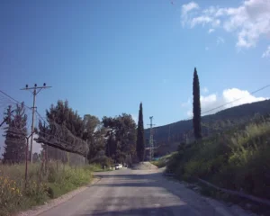
According to the field description published by Walid Khalidi in All That Remains, only scattered stone rubble remained at the village site amid thorny bushes, grass, and cactus. Part of the surrounding land was cultivated, while the remainder was used for grazing.
Khalidi's description derives from fieldwork conducted before the publication of All That Remains in 1992 and should not by itself be treated as direct verification of conditions in 2026.
Palestine Remembered now contains much more recent community documentation. A video item published on 27 August 2026 records a visit to Khubbayza dated 31 July 2026 and, according to its title, includes a tour through the village lands and encounters with people picking cactus fruit.
This provides unusually recent community documentation of the site, but it is not a comprehensive archaeological or professional field survey. The detailed physical description therefore remains grounded primarily in Khalidi's fieldwork, while noting that the site was documented in a community visit as recently as July 2026.
Sources
- PalQuestPalQuest – Interactive Encyclopedia of the Palestine Question: Khubbayza
- Palestine RememberedPalestine Remembered – Khubbayza, Haifa
- Palestine RememberedPalestine Remembered – Khubbayza entry from All That Remains
- Institute for Palestine StudiesInstitute for Palestine Studies – Walid Khalidi, All That Remains
- pcbs.gov.psPalestinian Central Bureau of Statistics – Historical Census Reports
- maktabatsabil.comGovernment of Palestine – Village Statistics 1945: Haifa Sub-District, Population and Land Ownership
- maktabatsabil.comGovernment of Palestine – Village Statistics 1945: Haifa Sub-District, Cultivable Land
- maktabatsabil.comGovernment of Palestine – Village Statistics 1945: Haifa Sub-District, Built-up and Non-Cultivable Land
- Palestine RememberedDr. Muhammad 'Aql – Khubbayza: Watan wa Judhur, local and oral-history documentation
- Palestine RememberedPalestine Remembered – Community visit to Khubbayza dated 31 July 2026
Photo gallery


Photos from the village's people
Photos sent in by visitors and published after review.
Add a photo of this village
Log in to add photos of this village.
Other villages from Haifa
More from the archive



 Download Our Palestine App
The whole archive in the palm of your hand: depopulated villages, the Nakba, the massacres and Al-Aqsa — free, with no ads to erase the story.
Download Our Palestine App
The whole archive in the palm of your hand: depopulated villages, the Nakba, the massacres and Al-Aqsa — free, with no ads to erase the story.



Comments
No comments yet — be the first to write one.
Add your comment
Name and email are optional. Comments appear after review.